Several Rounds of Severe Weather and Heavy Rainfall: June 22nd-27th, 2013

An active period of weather impacted the NWS Northern Indiana area during Saturday, June 22nd to Thursday, June 27th, 2013. During this period, several rounds of showers and thunderstorms moved across the local area. Some of these storms became severe, producing damaging winds, large hail, and torrential downpours. Short summaries of each day are below along with a map of storm reports and precipitation totals.
Saturday, June 22 and Sunday, June 23 - Scattered showers and thunderstorms fired both afternoons during the weekend of June 22nd-23rd. These storm were pulse-type in nature and non-severe for the most part. They were not able to sustain themselves due to weak shear and forcing. A few of the storms did become severe (in Huntington County, Indiana and Fulton County, Ohio) on June 22nd, producing damaging wind gusts as the storms collapsed.
Monday, June 24- Storms fired in eastern Iowa near a surface front and strengthened as they moved east into northern Illinois. As they propagated east across northern Illinois into the late afternoon hours, the line matured into a bow echo due to the presence of moderate instability and moisture inflow from the south. (See NWS Chicago's writeup here) The line progressed into the local area and produced wind damage as it moved east (mainly across La Porte and Starke counties). The bow echo began to weaken as it moved into central portions of the area (from Elkhart County south to Koscuisko County) as instability decreased and shear was relatively weak. The line also became outflow dominant with the strongest wind gusts occurring ahead of the actual storm. In some cases, the outflow produced 50-60 mph winds and sporadic tree damage.
 |
 |
| Radar - 8:30 pm EDT | Warnings and Storm Reports |
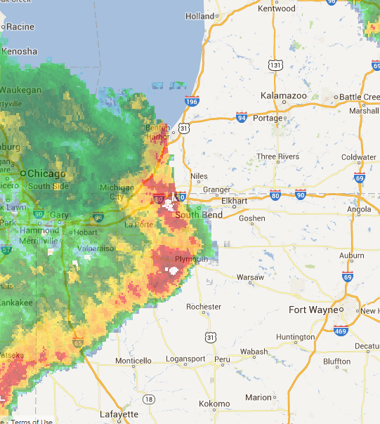
Tuesday, June 25- Storms fired along an existing outflow boundary (from previous day's storms) in southern lower Michigan and slowly moved southeast into northeast Indiana. Additional storms formed west and south of this line as an upper level disturbance moved into the area, providing better forcing. A majority of these storms became severe, producing large hail and wind damage. The storms were also slow-moving and trained over the same locations, producing heavy downpours and flash flooding in many locations across the area. As the night progressed, the storms fell below severe levels, but continued to produce heavy rainfall. This led to flooding, especially in northwest Indiana. La Porte was hardest hit as they received 4-6 inches of rain in northwest parts of the county. This caused devastating flooding and a few roadways to be washed out.
 |
 |
| Radar - 8:45 pm EDT | Warnings and Storm Reports |
Here are a few pictures of the flooding in La Porte County. Click on the thumbnails for a bigger image size.
 |
 |
|
Flooding in Michigan City - Courtesy La Porte County Skywarn |
Johnson Road Washed Out by Flood Waters |
Wednesday, June 26- Scattered thunderstorms fired during the afternoon hours on the 26th as another upper level disturbance rotated across the area. These storms were non-severe but did produce gusty winds less than 45 mph and heavy downpours. These storms were very slow-moving due to weak flow which led to rainfall rates greater than 2 inches per hour in some locations.
Thursday, June 27- The atmosphere became moderately unstable during the day as mostly clear skies allowed for a decent amount of surface heating. An upper level disturbance dropped southeast from Wisconsin into western Indiana which allowed for 30-50 knots of shear to nose east into the local area. This shear combined with the moderate instability and dewpoints in the low 70s allowed for storms to fire and maintain themselves long enough to become severe. The storms that became severe produced large hail (up to 2" diameter in some locations) and sporadic wind damage. Below is a radar image from approximately 8 pm EDT on the 27th which shows the storms firing on an axis generally from Berrien County, Michigan southeast toward Fort Wayne, IN.
 |
 |
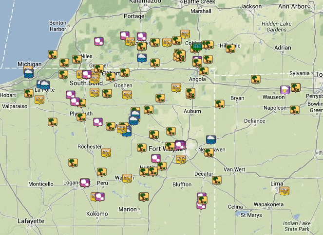
| Radar - 8:10 pm EDT | Warnings and Storm Reports |
Below is a map of storm reports received from June 22nd-June 27th. Click on the map to visit a website with an interactive version with a full listing of the reports.
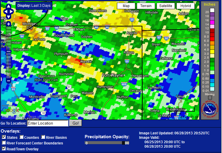
In addition to the severe weather, several rounds of heavy rainfall caused flash flooding in several locations across the area. The majority of this rain came with slow-moving storms that trained over the same areas. La Porte County, especially the Michigan City, was the hardest hit when 5 to 6 inches of rain fell on overnight on the 26th into the morning of the 27th. Below is a map with three day rainfall from the evening of June 25th through June 28th. To check out an interactive rainfall map, click on this link.
If you have pictures or videos from any of these events (especially of hail, wind damage, or flooding), we'd love to see them! You can post them to our Facebook page or tweet them to us on Twitter @NWSIWX
CEO

