JUNE 12-13, 2013
SEVERE WEATHER EVENT
Synoptic Overview
A stationary frontal boundary extended from a low pressure system in eastern Iowa across northern Illinois and Indiana on Wednesday afternoon. Surface based CAPE (Convective Available Potential Energy) was on the order of 3000 to 4000 J/kg along and south of the frontal boundary and mid-level lapse rates were between 8 and 9 degrees C/km, indicating that the atmosphere was very unstable. However, there was a large amount of slowly eroding CIN (Convective Inhibition) over the area that hindered storm development earlier in the day. 0-6km shear, a parameter that is used to determine how well an environment can sustain organized storms, was between 35 and 55 knots, which was ideal for supercell formation. By late afternoon, the CIN over the region was almost completely gone, allowing storms to initiate across northern Illinois and progress eastward with the advancing low pressure system.
SPC (Storm Prediction Center) placed much of northern Indiana, northern Illinois,southern lower Michigan and northwest Ohio under a high risk with the 1630 UTC Day One Convective Outlook with the concern for bow echo development across northern Illinois and a track across most of our forecast area.
A combination of supercell thunderstorms and bowing line segments, with many areas of rotation, moved through northern Indiana and northwest Ohio during the evening and overnight hours of Wednesday, June 12, 2013. Overnight and into the early hours of Thursday morning, June 13, the storms organized into a forward propapgating MCS (Mesoscale Convective System) as it progressed eastward to the coast. This is depicted in the radar loop below which goes from 6:30 pm EDT on the 12th until 12:16 am EDT on the 13th.

The SPC later categorized this severe bow echo as a, "low-end derecho". Below are images created by the SPC showing the progression of the system through time based on the radar and storm reports. Click on the images for a larger resolution.
 |
 |
The SPC also put out the following statement, describing the system:
- The event of Wednesday evening June 12th-Thursday morning June 13th can be considered a low-end derecho. While a few significant wind reports in excess of 70 mph occurred in Indiana, the lack of higher wind speeds/gusts along the entire track of the bow echo keep this event on the lower end.
- Widespread severe thunderstorms over the Midwest during the late evening, became organized into a squall line over Indiana before Midnight EDT. The line then accelerated east across Ohio, Pennsylvania and New Jersey through Thursday morning, June 13, 2013 with an average forward speed of 47 mph.
- The bow echo/derecho traveled over 400 miles in about 6 hours during its peak intensity resulting in over 100 damaging wind reports. The most significant damage appears to have occurred during the late evening across parts of Indiana.
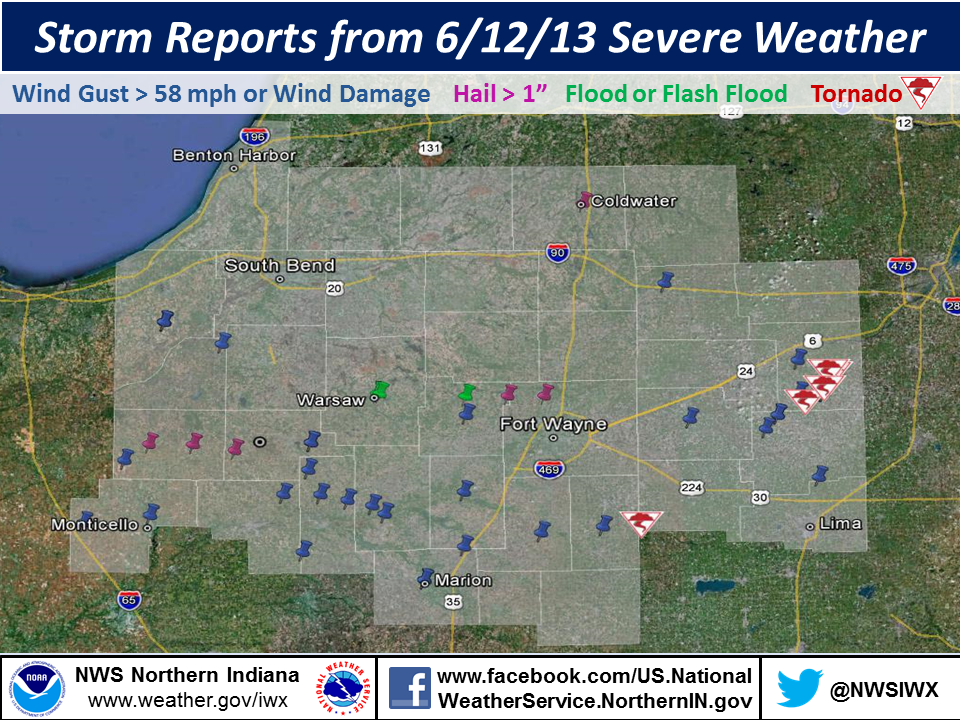
Storm Reports and Damage Survey Results
Below is an image of the storm reports gathered from this event.
The National Weather Service in Northern Indiana dispatched two damage survey crews to various parts of the county warning area to determine the nature and extent of these storms. Reports from these teams follow. Pictures from the event can be found on our Facebook page at this link.
Downburst in the town of Wabash
NATURE: STRAIGHT LINE WINDS
TIME: 1047 PM EDT (ESTIMATED BY RADAR)
LOCATION: NORTHWEST SIDE OF THE TOWN OF WABASH
WIND SPEED: ESTIMATED 90 TO 100 MPH WINDS
DESCRIPTION: A GRAIN SILO AND 2 POLE BARNS WERE COMPLETELY
DESTROYED WITH DEBRIS BLOWN SOUTHEAST. EXTENSIVE TREE DAMAGE WAS
FOUND ON THE NORTHWEST SIDE OF WABASH.

Tornado in Van Wert County
RATING: EF0
MAXIMUM ESTIMATED WIND SPEED: 85 MPH
PATH LENGTH: 0.7 MILES PATH
MAXIMUM WIDTH: 80 YARDS
TIME: 1127 PM EDT
LOCATION: WILLSHIRE OHIO /STATE ROAD 81 AT THE OHIO INDIANA BORDER
TO THE INTERSECTION OF GREEN STREET AND STATE ROAD 49/
DESCRIPTION: AN EF0 TORNADO TOUCHED DOWN ON THE WEST SIDE OF THE
TOWN OF WILLSHIRE ALONG STATE ROAD 81 NEAR THE INDIANA/OHIO BORDER
BEFORE TRAVELING DOWN GREEN STREET TO THE INTERSECTION OF GREEN
STREET AND SR 49. ONE WITNESS SAW TORNADO DESCEND IN HIS
YARD...SNAP OFF 2 LARGE TREES AND CONTINUE DOWN THE STREET. OTHER
TREE DAMAGE WAS NOTED. ANOTHER WITNESS SAW CONDENSATION VORTICIES
BEING INJECTED INTO THE FUNNEL AS HIS GARAGE WAS ROLLED OFF OF ITS
FOUNDATION. A PORTION OF THE HOUSE ROOF WAS REMOVED AND THROWN
OVER THE NEIGHBORS HOME. SEVERAL WINDOWS WERE ALSO BROKEN.
THIRTEEN TOTAL HOMES RECEIVED DAMAGE. TORNADO WAS ON THE GROUND
FOR LESS THAN 3 MINUTES. MAXIMUM WIND SPEEDS ESTIMATED AT 85 MPH.

4 Tornadoes in Henry County
DAMAGE SURVEY INDICATED SEVERAL BRIEF TORNADOES AMID DOWNBURST
CLUSTERS THROUGHOUT HENRY COUNTY.
TORNADO 1...
RATING: EF-1
MAXIMUM ESTIMATED WIND SPEED: 95 MPH
PATH LENGTH: 0.4 MILES PATH
WIDTH /MAXIMUM/: 50 YARDS
TIME: 1159 PM EDT JUNE 12...2013
LOCATION: 1 MILE NORTH OF HAMLER
DESCRIPTION: BARN DESTROYED WITH CONVERGENT PATTERN INDICATED IN
THE SOYBEAN FIELD TO THE NORTHEAST. WIND DAMAGE WAS NOTED ALL
ALONG PATH WITH SEVERAL TREE TRUNKS SNAPPED AND EVIDENCE OF
CYCLONIC CIRCULATION.
TORNADO 2...
RATING:EF-1
MAXIMUM ESTIMATED WIND SPEED: 95 MPH
PATH LENGTH: 0.2 MILES
PATH WIDTH: 30 YARDS
TIME: 1202 AM EDT JUNE 13...2013
LOCATION: 2.3 MILES SOUTHEAST OF MALINTA
DESCRIPTION: TORNADO TOUCHED DOWN ON SOUTH SIDE OF ROAD J BETWEEN
ROADS 7 AND 8 IN HENRY COUNTY WHERE A BARN WAS DESTROYED.
SIGNIFICANT DAMAGE OCCURRED TO A BARN AND HOUSE ON THE NORTH SIDE
OF THE ROAD INCLUDING A BEAM FROM THE BARN SOUTH OF THE ROAD STUCK
INTO THE NORTH SIDE OF THE HOME ON THE NORTH SIDE OF THE ROAD.
TORNADO 3...
RATING: EF-0
MAXIMUM ESTIMATED WIND SPEED: 80 MPH
PATH LENGTH: 0.36 MILES
PATH WIDTH: 15 YARDS
TIME: 1203 AM EDT JUNE 13...2013
LOCATION: 2.7 MILES SOUTHEAST OF MALINTA
DESCRIPTION: SMALL MULTI VORTEX TORNADO PATH WAS FOUND NEAR COUNTY
ROAD J BETWEEN COUNTY ROADS 6 AND 7. CONVERGENT SINGATURE WAS FOUND
THROUGH A WHEAT FIELD. SEVERAL TREES WERE UPROOTED. A POLE BARN
HAD DOORS COLLAPSED AND ONE WALL BLOWN DOWN.
TORNADO 4...
RATING: EF-0
MAXIMUM ESTIMATED WIND SPEED: 85 MPH
PATH LENGTH: 50 YARDS
PATH WIDTH: 25 YARDS
TIME: 1155 PM EDT JUNE 12...2013
LOCATION: 3 MILES EAST SOUTHEAST OF NEW BAVARIA
DESCRIPTION: BRIEF EF0 TORNADO TOUCHED DOWN AND DESTROYED A BARN
NEAR THE INTERSECTION OF COUNTY ROAD Y AND COUNTY ROAD 12A. THIS
DEBRIS WAS FOUND SCATTERED TO THE NORTH. THE TORNADO BECAME
OUTFLOW DOMINANT SHORTLY AFTER TOUCHDOWN. WIDESPREAD STRAIGHT
LINE WIND DAMAGE...INCLUDING EXTENSIVE TREE DAMAGE AND ROOF DAMAGE
TO HOUSES...WAS FOUND FOR OVER A MILE TO THE NORTHEAST OF THE
TORNADO PATH. THIS DAMAGE WAS ALL FOUND LAYING TO THE EAST AND
SHOWED NO EVIDENCE OF ROTATION FROM A CIRCULATION.
HAMLER DOWNBURST...
NATURE: STRAIGHT LINE WINDS
TIME: 1157 PM EDT JUNE 12...2013
LOCATION: THE TOWN OF HAMLER
WIND SPEED: ESTIMATED 90 MPH WINDS
DESCRIPTION: TWO AND A HALF MILE LONG AND 1 MILE WIDE DOWNBURST
SWATH WAS FOUND IN AND NEAR THE TOWN OF HAMLER. DAMAGE PATH BEGAN
NEAR TOWNSHIP ROAD D TO THE SOUTHEAST OF HAMLER AND CONTINUED NORTHEAST
TO THE NORTHERN AND EASTERN LIMITS OF THE TOWN OF HAMLER.
WIDESPREAD TREE AND POWER LINE DAMAGE WAS FOUND...ESPECIALLY IN
THE TOWN OF HAMLER. ALL DEBRIS WAS FOUND DEPOSITED TO THE EAST.

BENTLEY/OBERGFELL/GROSS

