Training thunderstorms formed along an outflow boundary Friday night and dropped an incredible amount of rainfall to portions of our forecast area. A swath through the central portion of our county warning area saw between 2 to 5 inches of rainfall with a few locations near 5.5 inches! This map shows how much rainfall bell between 9 am Friday and 9 am Saturday.

What we found most interesting about this event was regarding the storm total precipitation estimation done by our radar. The new dual pol precipitation estimation was virtually spot on! The old (legacy) method of precipitation estimation was underestimating totals by as much as half.
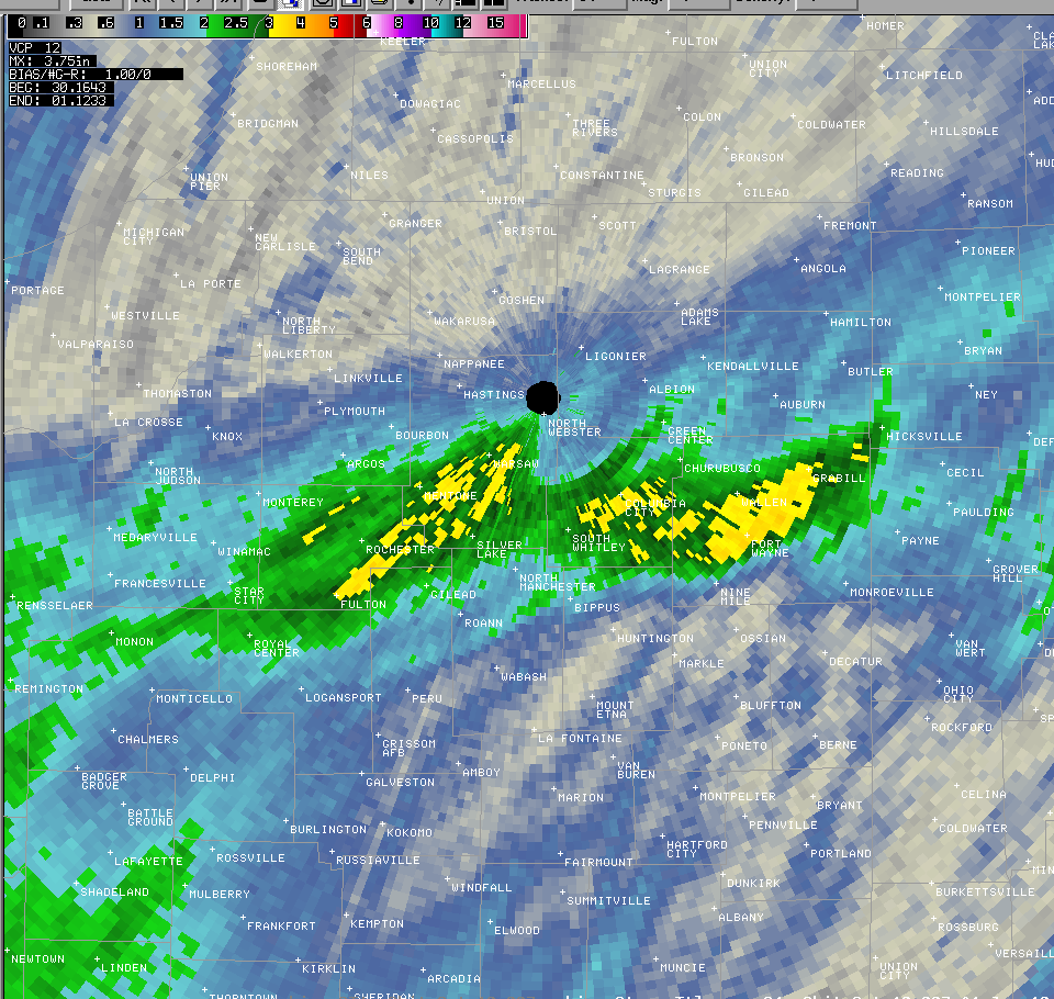
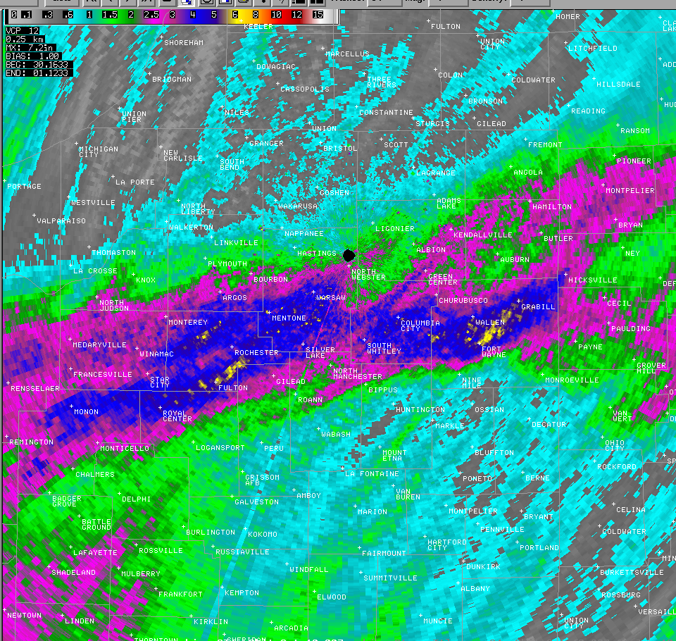
The legacy product estimated rainfall totals of 2 inches or greater anywhere the colors are green and 3 to 3.5 inches where the colors are yellow. The dual pol estimated rainfall was 4 inches or greater everywhere there is blue and 5 inches or greater everywhere the image is yellow. When comparing the dual pol estimation to the observed precipitation map, they show almost identical amounts!
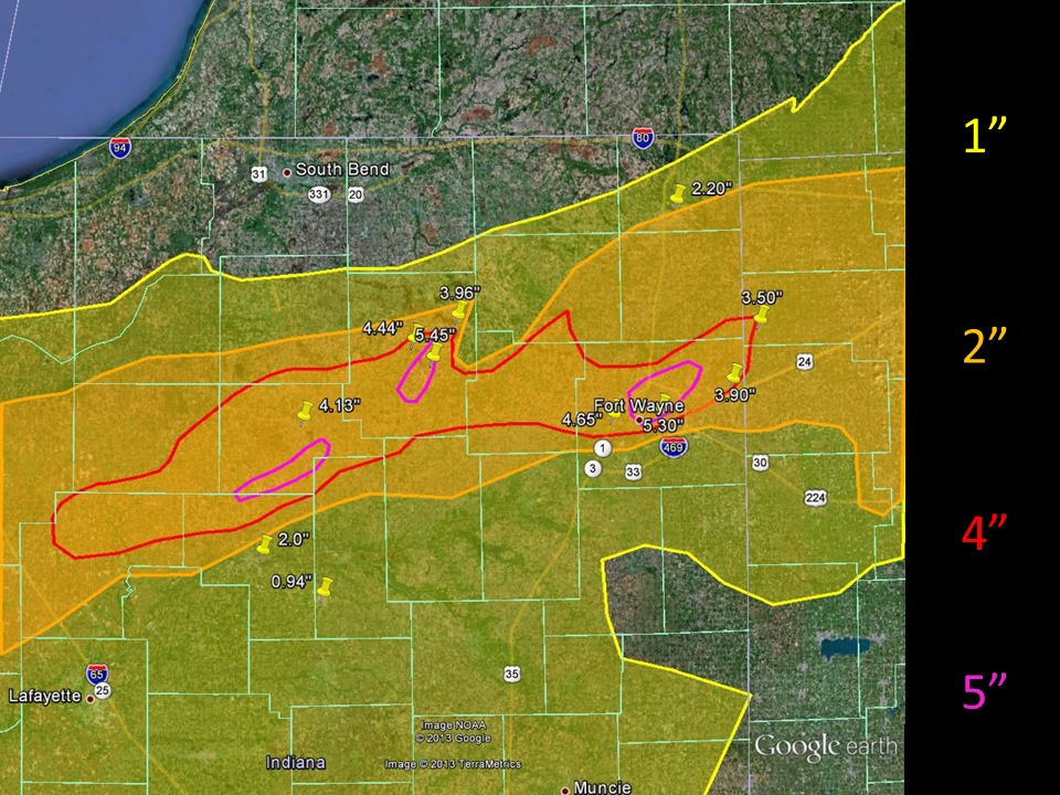
The map below shows contours of the dual-pol precipitation estimation with actual rainfall amounts overlaid as thumbtacks. The accuracy of the dual-pol estimation is astonishing!
| ...LOCATION... | TIME | Amount | ||
| 3 NE FORT WAYNE (ALLEN IN) (COCORAHS) | 700 | AM | 5.27 | IN |
| 1 ESE WALLEN (ALLEN IN) (COCORAHS) | 800 | AM | 4.84 | IN |
| 3 ENE WALLEN (ALLEN IN) (COCORAHS) | 1000 | AM | 4.77 | IN |
| WARSAW 5SW (KOSCIUSKO IN) (COOP) | 900 | AM | 4.75 | IN |
| 1 NNE COLUMBIA CITY (WHITLEY IN) | 700 | AM | 4.73 | IN |
| 1 E WINONA LAKE (KOSCIUSKO IN) | 800 | AM | 4.7 | IN |
| BRENTWOOD ELEMENTARY SCHOOL - CSO | 900 | AM | 4.65 | IN |
| 1 NNE WINONA LAKE (KOSCIUSKO IN) | 730 | AM | 4.64 | IN |
| MAUMEE RIVER AT ANTHONY BLVD (ALLEN IN) | 900 | AM | 4.58 | IN |
| 1 NNW WARSAW (KOSCIUSKO IN) (COCORAHS) | 700 | AM | 4.44 | IN |
| SPY RUN AT FRANKE PARK (ALLEN IN) | 900 | AM | 4.36 | IN |
| PRICE ELEMENTARY SCHOOL - CSO | 900 | AM | 4.25 | IN |
| 1 N ROLLING HILLS (ALLEN IN) (COCORAHS) | 800 | AM | 4.2 | IN |
| CITY/COUNTY BUILDING (ALLEN IN) (UCOOP) | 900 | AM | 4.15 | IN |
| GETZ ROAD FIRE STATION (WHITLEY IN) | 900 | AM | 4.14 | IN |
| ROCHESTER (FULTON IN) (770 FT)(COOP) | 700 | AM | 4.13 | IN |
| FAIRFIELD ELEMENTARY SCHOOL - CSO | 900 | AM | 4.07 | IN |
| STUDY ELEMENTARY SCHOOL - CSO | 900 | AM | 4.07 | IN |
| BUNCHE ELEMENTARY SCHOOL - CSO | 900 | AM | 3.95 | IN |
| 4 W LEO-CEDARVILLE (ALLEN IN) | 800 | AM | 3.74 | IN |
| 3 ESE HUNTERTOWN (ALLEN IN) (COCORAHS) | 700 | AM | 3.71 | IN |
| ADAMS ELEMENTARY SCHOOL - CSO | 900 | AM | 3.63 | IN |
| MAUMEE RIVER AT COLSEUM BLVD IN FORT WA | 900 | AM | 3.62 | IN |
| BELLE VISTA BRIDGE (ALLEN IN) (UCOOP) | 900 | AM | 3.37 | IN |
| HARRISON HILL ELEMENTARY SCHOOL - CSO | 900 | AM | 3.36 | IN |
| 1 SSW OSWEGO (KOSCIUSKO IN) (COCORAHS) | 700 | AM | 3.34 | IN |
| DUPONT LIBRARY - CSO (ALLEN IN) (UCOOP) | 900 | AM | 3.33 | IN |
| HOMESTEAD/LIBERTY MILLS FIRE STATION | 900 | AM | 3.23 | IN |
| IRWIN ELEMENTARY SCHOOL - CSO | 900 | AM | 3.21 | IN |
| AVILLA 3SW (NOBLE IN) (990 FT)(COOP) | 900 | AM | 3.18 | IN |
| NORTHERN INDIANA WFO (KOSCIUSKO IN) | 800 | AM | 2.97 | IN |
| 2 N NORTH WEBSTER (KOSCIUSKO IN) | 800 | AM | 2.9 | IN |
| WOODBURN 3N (ALLEN IN) (710 FT)(COOP) | 700 | AM | 2.9 | IN |
| 2 W AVILLA (NOBLE IN) (COCORAHS) | 700 | AM | 2.8 | IN |
| 1 E BIG LAKE (NOBLE IN) (COCORAHS) | 700 | AM | 2.79 | IN |
| GARRETT (DE KALB IN) (880 FT)(COOP) | 700 | AM | 2.54 | IN |
| HICKSVILLE (DEFIANCE OH) (790 FT)(COOP) | 645 | AM | 2.52 | IN |
| FISH CRK AT HAMILTON, IN. (STEUBEN IN) | 1045 | AM | 2.44 | IN |
| HUDSON (STEUBEN IN) (988 FT)(COCORAHS) | 900 | AM | 2.42 | IN |
| IRENE BYCON SANITARIUM (ALLEN IN) | 900 | AM | 2.39 | IN |
| TIPPECANOE RIVER AT NORWAY (WHITE IN) | 1045 | AM | 2.39 | IN |
| 2 E HAMILTON (STEUBEN IN) (COCORAHS) | 700 | AM | 2.37 | IN |
| STRYKER (WILLIAMS OH) (700 FT)(COOP) | 700 | AM | 2.11 | IN |
| 2 N AUBURN (DE KALB IN) (COCORAHS) | 800 | AM | 2.1 | IN |
| 1 NE LAKE WAWASEE (KOSCIUSKO IN) | 800 | AM | 2.01 | IN |
| 1 E LOGANSPORT (CASS IN) (COCORAHS) | 700 | AM | 2 | IN |
OBSERVATIONS ARE COLLECTED FROM A VARIETY OF SOURCES WITH VARYING
EQUIPMENT AND EXPOSURES. NOT ALL DATA LISTED IS CONSIDERED OFFICIAL. THE
NATIONAL WEATHER SERVICE THANKS ITS PRIVATE AND PUBLIC PARTNERS FOR
PROVIDING US WITH THIS DATA.
A few pictures of the flooding can be seen on our Facebook page and our Twitter @NWSIWX.

