An early spring snowstorm blanketed portions of the local area overnight on March 24th into the morning hours of March 25th. The local area was on the northern fringe of the heaviest snow across the region as a strong low pressure system moved northeast from the central Plains into the Ohio Valley.
 |
 |
 |
| Surface Analysis 18Z March 24, 2013 | Surface Analysis 00Z March 25, 2013 | Surface Analysis 12Z March 25, 2013 |
The image below shows 48 hour snowfall totals across the region ending around ~7am local time on March 26th. The highest amounts were found over central Illinois where many locations received over a foot of snow! There was a sharp cutoff between locations that received heavy snow (greater than 6 inches) where northern locations saw no snow at all.

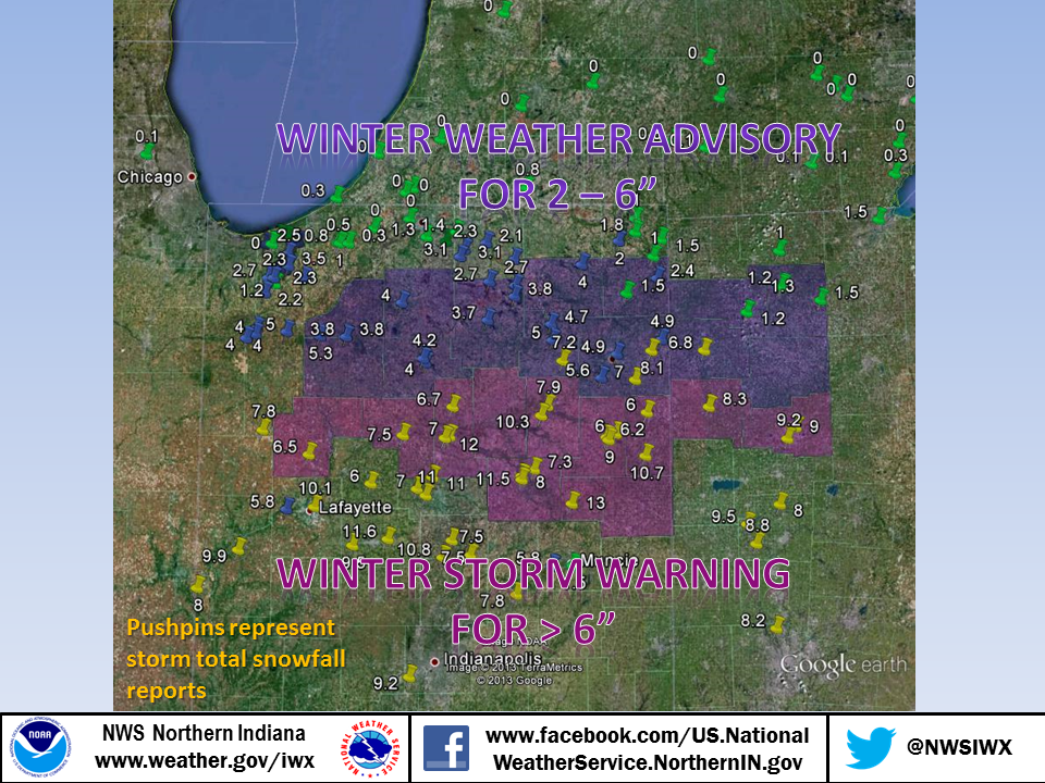
The map below shows local snowfall reports over laid on the winter weather advisory and winter storm warnings that were in effect during the event. Most locations within the warning area received 6-12" with the highest amounts across the southern portion of the local area. Amounts of generally 2-6" were found in the advisory area.
The maps and table below show snowfall totals for the local area through ~9am on the 26th.

 |
 |
| 24 Hour Snowfall Ending 9am 3/25/2013 | 24 Hour Snowfall Ending 9am 3/26/2013 |
| Location |
Snowfall (Inches) |
Location | Snowfall (Inches) |
| Hartford City 0.2 NNW | 13 | De Motte 0.8 NNW | 4 |
| Galveston 1.0 ESE | 12 | De Motte 1.2 SSW | 4 |
| 2 WSW Peru | 12 | De Motte 4.1 SW | 4 |
| Frankfort 4.9 ENE | 11.6 | Plymouth 2.5 WSW | 4 |
| Marion EOC | 11.5 | Kendallville 4.5 NW | 4 |
| Kokomo 4.0 WNW | 11 | ROCHESTER | 4 |
| 1 ESE Galveston | 11 | Chesterton 4.2 E | 3.9 |
| Atlanta 4.4 W | 10.8 | North Webster 2.3 N | 3.8 |
| Berne | 10.7 | North Judson 5.7 ESE | 3.8 |
| Andrews 3.2 ESE | 10.3 | North Judson 5.7 ESE | 3.8 |
| Lafayette 2.2 NE | 10.1 | Warsaw 1.1 NNW | 3.7 |
| Attica 3.4 SSW | 9.9 | Valparaiso 1.4 ENE | 3.5 |
| Mulberry 5.6 SSE | 9.5 | Valparaiso 0.6 SE | 3.4 |
| Fort Loramie 0.8 NNW | 9.5 | Westerville 0.2 WNW | 3.3 |
| INDIANAPOLIS | 9.2 | Wakarusa 0.3 WSW | 3.1 |
| LIMA WWTP | 9.2 | Millersburg 0.5 SW | 3.1 |
| Bluffton 0.9 SE | 9 | New Albany 2.8 SSE | 3 |
| Lima 2.7 NE | 9 | Bellevue 4.9 S | 3 |
| Houston 1.3 NNE | 8.8 | Columbus 9.3 NNE | 2.8 |
| VAN WERT 1 S | 8.3 | Milford 0.9 N | 2.7 |
| DAYTON OHIO | 8.2 | Syracuse 3.0 ESE | 2.7 |
| Woodburn 2.8 WSW | 8.1 | Valparaiso 5.7 WSW | 2.7 |
| MARION 2 N | 8 | Valparaiso 0.9 NNW | 2.6 |
| Anna 3.1 NNW | 8 | Valparaiso 4.6 NNE | 2.5 |
| PERRYSVILLE 4 WNW | 8 | Valparaiso 1.8 N | 2.5 |
| Huntington 0.3 W | 7.9 | Butler 0.5 NNE | 2.4 |
| Remington 0.3 N | 7.8 | Portage 0.9 ESE | 2.4 |
| Madison Co | 7.8 | Wakarusa 2.4 NNE | 2.3 |
| Logansport 0.9 E | 7.5 | Valparaiso 4.3 SW | 2.3 |
| Atlanta 4.1 ENE | 7.5 | Marble Cliff 1.1 WNW | 2.3 |
| Tipton 1.3 NW | 7.5 | WANATAH 2 WNW | 2.3 |
| Marion 5.6 NE | 7.3 | Hebron 3.7 NE | 2.2 |
| Columbia City 6.6 SSE | 7.2 | Goshen 1.9 NW | 2.1 |
| Fort Wayne 9.1 SE | 7 | BUFFALO | 2 |
| Kokomo 7.2 WNW | 7 | Valparaiso 1.8 NW | 2 |
| PERU | 7 | Hudson 4.6 N | 2 |
| PAULDING | 6.8 | MINNEAPOLIS | 2 |
| Denver 1.3 NE | 6.7 | ROANOKE | 2 |
| CHALMERS 5 W | 6.5 | ST LOUIS | 2 |
| BLUFFTON 1 N | 6.2 | Porter 0.6 S | 1.9 |
| DECATUR 1 N | 6 | Port Clinton 2.5 W | 1.9 |
| Flora 0.3 S | 6 | ANGOLA | 1.8 |
| Bluffton 3.0 ENE | 6 | Mishawaka 5.9 SE | 1.6 |
| Yorktown 1.1 NNW | 5.8 | Auburn 0.8 NE | 1.5 |
| West Lafayette 5.1 WSW | 5.8 | Muncie 1.2 SE | 1.5 |
| FORT WAYNE ASOS | 5.6 | Angola 8.7 ESE | 1.5 |
| Bluffton 4.1 N | 5.6 | McClure 3.4 SSE | 1.5 |
| North Judson 3.9 SW | 5.3 | Toledo 2.4 ENE | 1.5 |
| Wheatfield 1.4 ENE | 5 | Elkhart 4.8 SW | 1.4 |
| Columbia City 0.5 NNE | 5 | Chesterton 1.4 ENE | 1.3 |
| VAN WERT 1 S | 5 | South Bend 4.6 SE | 1.3 |
| Fort Wayne 2.6 NE | 4.9 | Napoleon 0.6 WSW | 1.3 |
| Woodburn 3 N | 4.9 | Valparaiso 5.5 SSW | 1.2 |
| Logansport 3.9 NNW | 4.8 | Defiance 0.9 E | 1.2 |
| Columbia City 5.4 N | 4.7 | Napoleon 0.3 NNW | 1.2 |
| Logansport 2.2 NNW | 4.2 | La Porte 1.6 SW | 1 |
| Rochester 2.4 NW | 4.2 | Hamilton 1.7 E | 1 |
Thanks to all the spotters, media, emergency managers, and public who sent in snowfall reports during the storm!
CEO

