A low pressure system moved across the Tennessee and Ohio Valleys during the evening of December 28th into the morning of the 29th. This system brought another round of snow to the area, especially locations across the southeast portion of the local area. Snowfall amounts ranged from less than half an inch in the northwest to 4-6 inches in the southeast. As with the December 26th event, the heaviest snowfall amounts remained south of the local area across central and southern Indiana.
The images below shows the progression of the system along with a U.S. radar composite. Click on the the thumbnail for higher resolution image.
 |
 |
 |
 ; ; |
| Dec 29th 00Z (Dec 28 7 pm EST) | Dec 29th 03Z (Dec 28 10 pm EST | December 29th 06Z (1 am EST) | December 29th 12Z (7 am EST) |
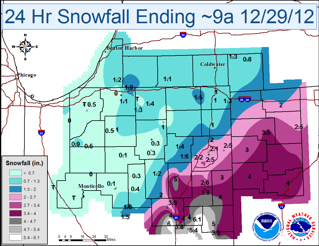
The image below shows snowfall totals from the storm across the region. This product is an objective analysis of NWS Cooperative Observer Program (COOP) and Community Collaborative Rain, Hail and Snow Network (CoCoRaHS) snowfall reports. CoCoRaHS data is from non-NWS sources and may have not been fully quality controlled. Daily snowfall analysis is available here.

The map and table below show 24 hour snowfall totals across the local area from the event. Snowfall in northwest portions of the area was due to a weak system that passed through during the morning of December 28th and produced trace - 2 inch amounts.
The table below shows some of the highest snowfall reports from southeast portions of the area.
| Location | Snowfall (Inches) | Time/Date of Measurement |
| INDIANA | ||
| ...ADAMS COUNTY... | ||
| 1 WSW BERNE | 4 | 700 AM 12/29 |
| ...ALLEN COUNTY... | ||
| 5 SW FORT WAYNE | 3.2 | 700 AM 12/29 |
| 3 NE FORT WAYNE | 2.5 | 700 AM 12/29 |
| 3 N WOODBURN | 2.5 | 700 AM 12/29 |
| ...BLACKFORD COUNTY... | ||
| NNW HARTFORD CITY | 5.1 | 700 AM 12/29 |
| HARTFORD CITY | 4 | 700 AM 12/29 |
| ...GRANT COUNTY... | ||
| 1 SW GAS CITY | 4 | 700 AM 12/29 |
| 3 NNW SHAMROCK LAKES | 4 | 700 AM 12/29 |
| N MATTHEWS | 3.8 | 700 AM 12/29 |
| 5 E MARION | 3 | 830 AM 12/29 |
| ...HUNTINGTON COUNTY... | ||
| HUNTINGTON WWTP | 2 | 700 AM 12/29 |
| ...JAY COUNTY... | ||
| 5 SW PORTLAND | 5 | 700 AM 12/29 |
| ...WELLS COUNTY... | ||
| 1 SE BLUFFTON | 3.8 | 700 AM 12/29 |
| 1 N BLUFFTON | 3.7 | 800 AM 12/29 |
| 4 N BLUFFTON | 2.6 | 700 AM 12/29 |
| OHIO | ||
| ...ALLEN COUNTY... | ||
| 3 NE LIMA | 4 | 700 AM 12/29 |
| ...DEFIANCE COUNTY... | ||
| DEFIANCE | 3 | 815 AM 12/29 |
| ...HENRY COUNTY... | ||
| 3 SSE MCCLURE | 2.5 | 700 AM 12/29 |
| ...PAULDING COUNTY... | ||
| PAULDING | 3 | 700 AM 12/29 |
| ...PUTNAM COUNTY... | ||
| OTTAWA | 4 | 650 AM 12/29 |
| ...VAN WERT COUNTY... | ||
| 1 S VAN WERT 1S | 4 | 1000 AM 12/29 |
| CONVOY | 3.5 | 942 AM 12/29 |
| OHIO CITY | 3.5 | 101 AM 12/29 |
Page compiled by CEO
12/30/2012

