A band of intense lake effect snow developed across far northwest Indiana during the evening hours on Friday, February 10th. This band produced very heavy snowfall rates on the order of 2 to 4 inches per hour across Porter county in northwest Indiana. This band began to shift eastward during the overnight hours into early Saturday morning, reaching western La Porte and western Starke counties shortly after midnight producing heavy snowfall across southwest Berrien, La Porte, and Starke counties. The band maintained a fairly steady west to east progression until reaching far eastern Lake Michigan where heavy lake effect snow became anchored over portions of Berrien, Starke, La Porte, and western St. Joseph Indiana counties Saturday morning.
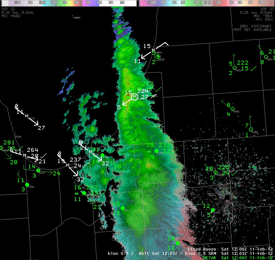
An arctic cold front tracking through the region brought very cold air over the relatively much warmer Lake Michigan waters. As this occurs, it is common for an axis of convergence to develop in the wind field over Lake Michigan that helps produces such strongly banded lake effect snow events. A reflection of this convergence can even be seen as this band shifted eastward into southwest lower Michigan during the morning. The following is radar imagery and surface/marine observations from approximately 7am EST Saturday morning. Note the northeast winds being reported along the southwest lower Michigan shoreline with stronger northwest winds across the northwest Indiana shoreline giving some sense as to the low level convergence helping to maintain the lake effect snow bands:
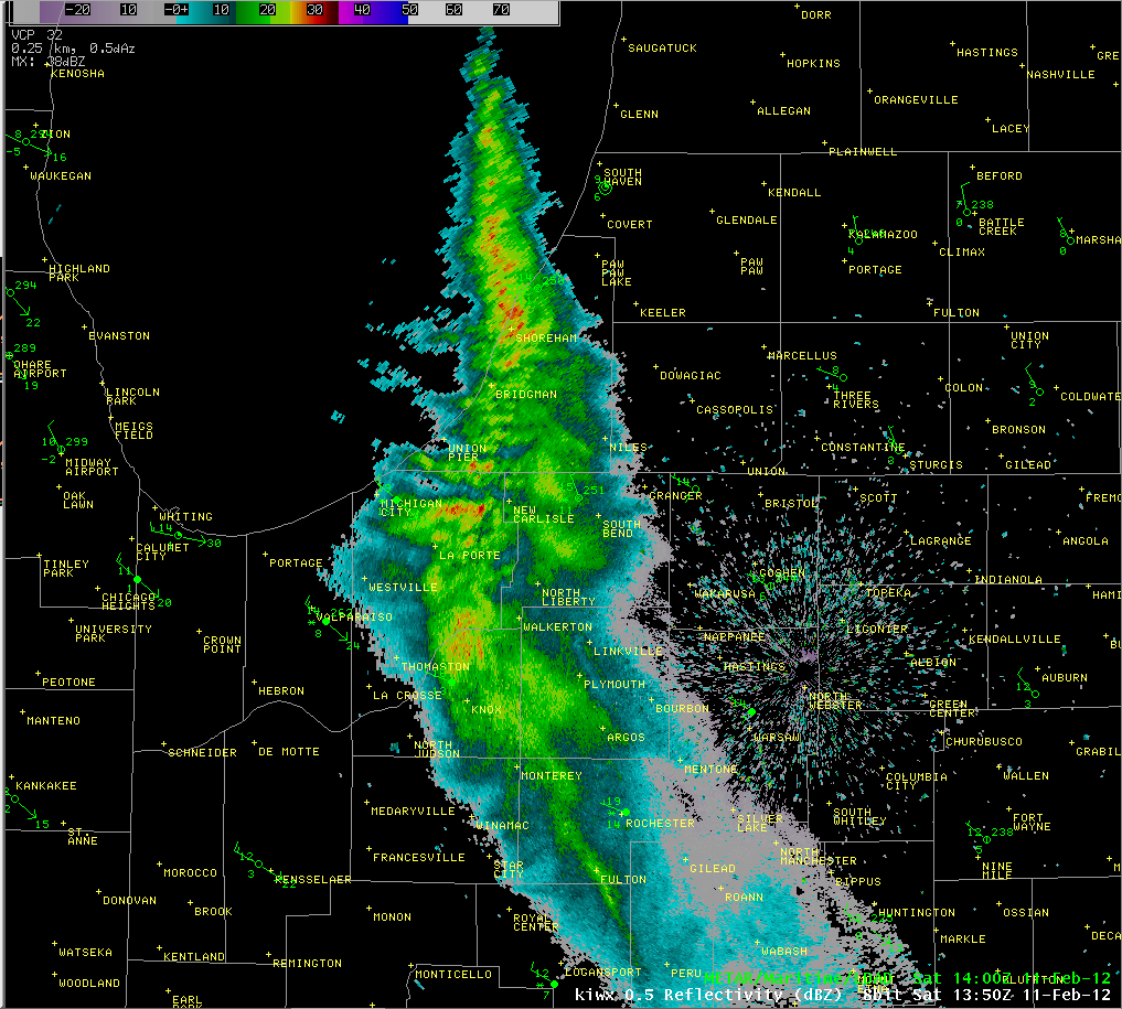
The following radar imagery is from approximately two hours later. Note how the band strengthened over this two hour period with very little change in its placement from the 7am imagery. Some of the heaviest snowfall rates were reported in the mid to late morning hours. Reports of 15 inches of snow in a 6 hour period were received across portions of Berrien county spanning 5am and 11am EST, which equates to an average snowfall rate of 2.5 inches per hour for a 6 hour period.
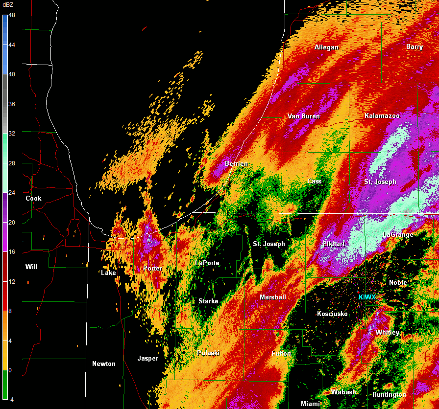
With the very localized nature of the heaviest snow in lake effect snow events, it can be difficult to produce an accurate map displaying all of in the intricate details in the distribution of snow that fell. Storm total snowfall accumulations usually vary significantly over short distances for some of the stronger lake effect snow events, as was the case with this event. The following map can at least provide a general sense as to the orientation of the heaviest snow amounts received during this storm from Friday afternoon through Saturday night. A text listing of some reports of storm total snowfall is also provided below the map:

PUBLIC INFORMATION STATEMENT
SPOTTER REPORTS
NATIONAL WEATHER SERVICE NORTHERN INDIANA
241 PM EST SAT FEB 11 2012
********************STORM TOTAL SNOWFALL********************
LOCATION STORM TOTAL TIME/DATE COMMENTS
SNOWFALL OF
/INCHES/ MEASUREMENT
INDIANA
...ADAMS COUNTY...
1 WSW BERNE 1.5 700 AM 2/11 0.06 WATER EQUIVALENT.
...ALLEN COUNTY...
5 SW FORT WAYNE 2.3 700 AM 2/11
5 WSW FORT WAYNE 2.0 1000 AM 2/11 0.26 WATER EQUIVALENT.
...LA PORTE COUNTY...
1 W HUDSON LAKE 11.0 100 PM 2/11
2 SW LA PORTE 8.2 1000 AM 2/11 0.41 WATER EQUIVALENT.
LA PORTE 7.6 1021 AM 2/11
5 ESE TRAIL CREEK 6.5 1000 AM 2/11 0.40 WATER EQUIVALENT.
3 NW LA PORTE 6.5 1000 AM 2/11 0.46 WATER EQUIVALENT.
1 SSW MICHIGAN CITY 6.5 800 AM 2/11 0.33 WATER EQUIVALENT
6 N LA PORTE 6.3 700 AM 2/11 0.32 WATER EQUIVALENT
1 SSW LA PORTE 6.0 700 AM 2/11 0.33 WATER EQUIVALENT
UNION MILLS 5.5 800 AM 2/11
1 E LA PORTE 5.2 800 AM 2/11 0.27 LIQUID EQUIVALENT
KINGSBURY 3.5 800 AM 2/11 0.16 WATER EQUIVALENT
...PULASKI COUNTY...
5 N MEDARYVILLE 6.0 800 AM 2/11
...ST. JOSEPH COUNTY...
WALKERTON 8.0 1231 PM 2/11
...STARKE COUNTY...
2 NNE KNOX 11.0 100 PM 2/11
GROVERTOWN 5.0 1030 AM 2/11
6 ESE NORTH JUDSON 4.0 1000 AM 2/11
4 SW NORTH JUDSON 4.0 1000 AM 2/11
...STEUBEN COUNTY...
5 NW ANGOLA 2.5 700 AM 2/11 0.12 WATER EQUIVALENT
5 N HUDSON 2.0 700 AM 2/11 0.11 WATER EQUIVALENT
4 NNW HUDSON 1.3 725 AM 2/11 STORM TOTAL.
...WELLS COUNTY...
1 SE BLUFFTON 1.0 800 AM 2/11 0.10 WATER EQUIVALENT.
...WHITLEY COUNTY...
7 SSE COLUMBIA CITY 1.3 700 AM 2/11 0.11 WATER EQUIVALENT.
MICHIGAN
...BERRIEN COUNTY...
SAINT JOSEPH 20.5 120 PM 2/11
STEVENSVILLE 18.0 200 PM 2/11
2 SSE STEVENSVILLE 15.5 1010 AM 2/11
1 S SAINT JOSEPH 15.0 139 PM 2/11
2 N STEVENSVILLE 15.0 1107 AM 2/11
BUCHANAN 6.0 949 AM 2/11
NEW BUFFALO 5.0 800 AM 2/11 0.35 WATER EQUIVALENT.
...HILLSDALE COUNTY...
6 ENE JONESVILLE 3.0 800 AM 2/11
LITCHFIELD 2.7 700 AM 2/11 0.23 WATER EQUIVALENT.
...ST. JOSEPH COUNTY...
COLON 2.8 904 AM 2/11
It is interesting to examine the larger scale evolution of this lake effect snow event. The following radar loop runs from approximately 7pm EST Friday evening to about 1pm EST Saturday afternoon. The primary band produced very heavy snow in Porter county Friday evening, with even some reports of lightning and thunder near Valparaiso University. The heaviest snow band began to shift eastward at a steadier pace during the overnight hours, before becoming anchored across eastern Lake Michigan into southwest lower Michigan. Thanks to everyone who submitted snowfall reports during the event!
Bentley/Greenawalt/Marsili

