Many locations across central portions of the NWS Northern Indiana's County Warning Area (CWA) saw accumulating snowfall on Saturday morning, 2/4/2012. The band of locally heavy snowfall was very narrow in width and hit portions of Kosciusko, Noble, Whitley, DeKalb, and Allen counties in Indiana and Paulding and Defiance counties in Ohio. This occurred due to the formation of a "banded precipitation structure" underneath a strong jet streak aloft which led to intense frontogenesis as shown in Fig 1. Figure 2 shows the actual water vapor satellite image from the event which matches the conceptual model in Figure 1 fairly well. This complex atmospheric process can easily be seen in the accompanying animation in Fig 3. In this case, a band of very heavy snow developed over a localized area for several hours as a low pressure system strengthened over northeast Kansas (Radar loop in Fig 4). Under this mesoscale snowband, temperatures cooled just enough due to strong, deep vertical ascent to allow the precipitation to fall in the form of snow. Locations just to the south and west of these areas saw mainly rain, as temperatures were just above freezing.
 |
| Fig 1 |
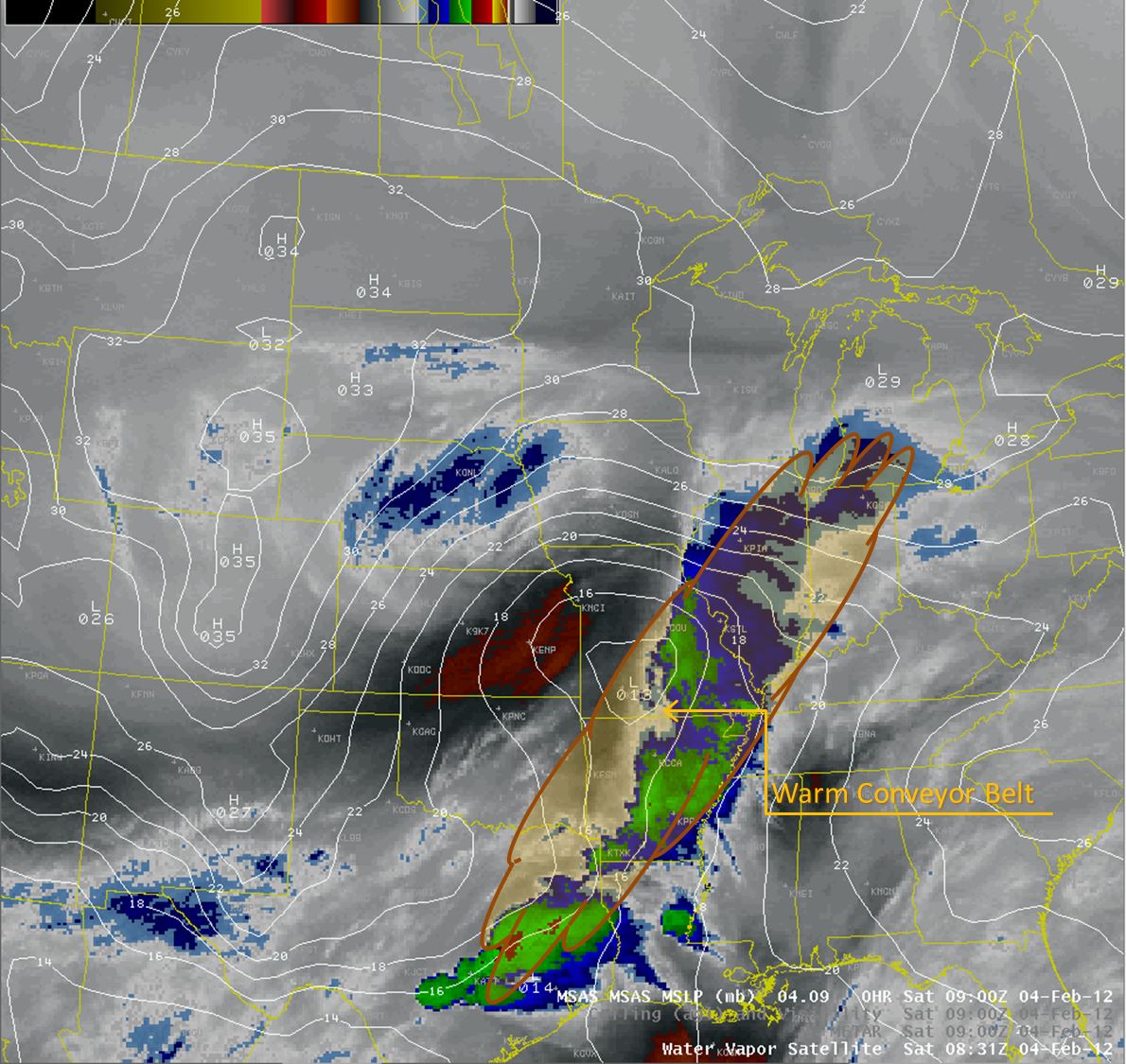 |
| Fig 2 |
| Fig 3 |
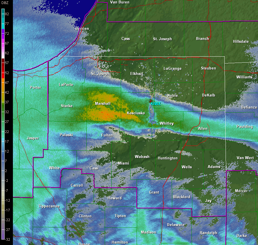 |
| Fig 4 |

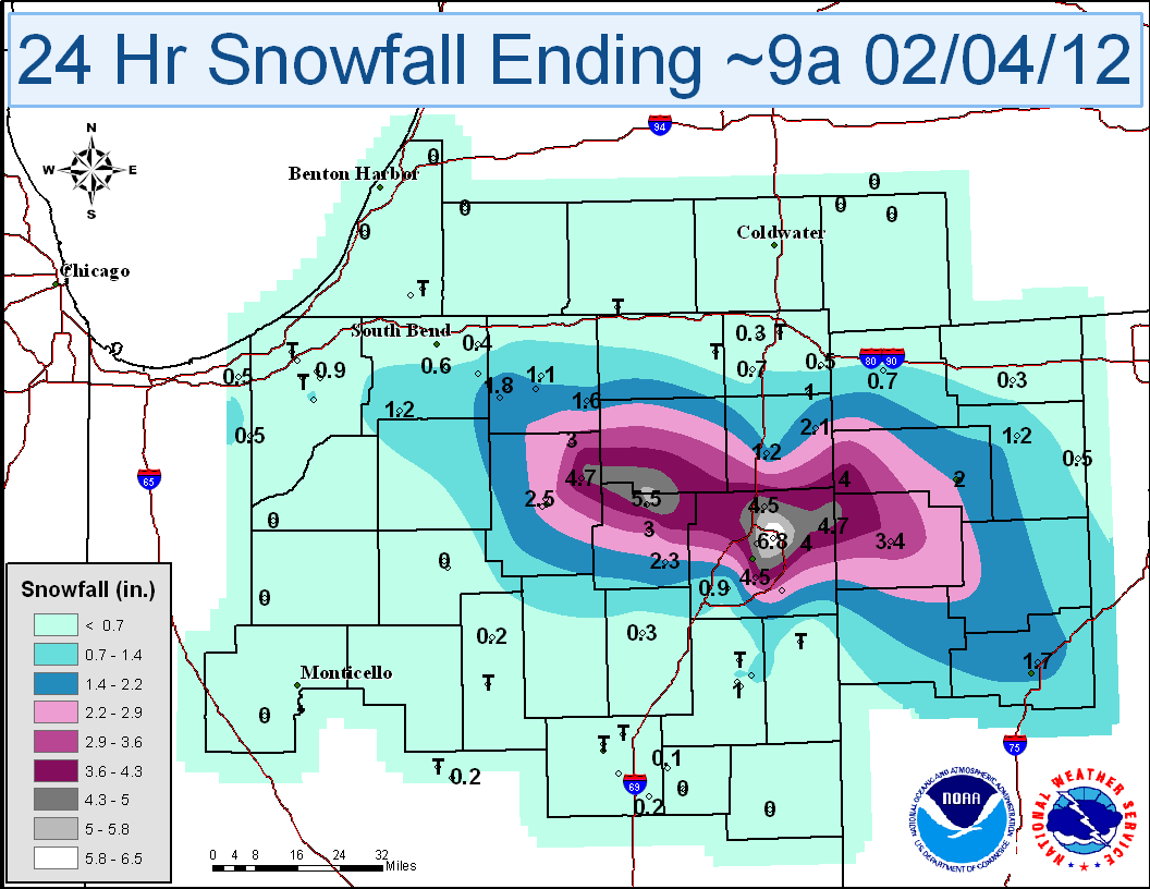
Liquid precipitation and snowfall totals can be see in the images below. (Click on the image to view full size)
 |
 |
PUBLIC INFORMATION STATEMENT SPOTTER REPORTS
NATIONAL WEATHER SERVICE NORTHERN INDIANA
1041 AM EST SAT FEB 4 2012

********************STORM TOTAL SNOWFALL********************
LOCATION          STORM TOTAL     TIME/DATE   COMMENTS
                    SNOWFALL           OF
                    /INCHES/     MEASUREMENT
INDIANA
...ALLEN COUNTY...
   7 NE FORT WAYNE        6.8   900 AM  2/04
   3 ESE WALLEN           6.8   857 AM  2/04  STORM TOTAL SO FAR.
   6 N FORT WAYNE         6.0   921 AM  2/04
   4 ENE WALLEN           6.0   750 AM  2/04
   4 NE FORT WAYNE        5.8   750 AM  2/04
   10 NNE FORT WAYNE      4.8   810 AM  2/04
   3 N WOODBURN           4.7   700 AM  2/04
   2 NW LEO-CEDARVILLE    4.5   800 AM  2/04
   3 WSW WOODBURN         4.0   700 AM  2/04
   7 N FORT WAYNE         4.0   530 AM  2/04
   3 ESE HUNTERTOWN       2.0   530 AM  2/04
...DEKALB COUNTY...
   BUTLER                 2.1   700 AM  2/04
...ELKHART COUNTY...
   WAKARUSA               2.1   700 AM  2/04
   1 SW MILLERSBURG       1.6   700 AM  2/04
   3 WSW GOSHEN           1.4   700 AM  2/04
...GRANT COUNTY...
   MARION                 0.2   841 AM  2/04
...KOSCIUSKO COUNTY...
   2 SW NORTH WEBSTER     4.7   700 AM  2/04
   2 N NORTH WEBSTER      4.4   700 AM  2/04

...NOBLE COUNTY...
   4 W ALBION             3.5   754 AM  2/04
   2 SW CROMWELL          3.2   545 AM  2/04
...ST. JOSEPH COUNTY...
   6 SE MISHAWAKA         0.9   600 AM  2/04
   5 SE SOUTH BEND        0.6   830 AM  2/04
...STEUBEN COUNTY...
   4 N HUDSON             0.8   747 AM  2/04  0.10 WATER EQUIVALENT
...WELLS COUNTY...
   3 ENE BLUFFTON         1.3   830 AM  2/04
...WHITLEY COUNTY...
   5 N COLUMBIA CITY      5.5   700 AM  2/04
   CHURUBUSCO             4.5   912 AM  2/04
   1 NNE COLUMBIA CITY    3.0   700 AM  2/04
   COLUMBIA CITY          2.3   710 AM  2/04
   4 S COLUMBIA CITY      2.0   815 AM  2/04

OHIO

...ALLEN COUNTY...
   3 NE LIMA              1.7   730 AM  2/04
...DEFIANCE COUNTY...
   HICKSVILLE             4.0   800 AM  2/04
   1 E DEFIANCE           2.0   800 AM  2/04
   DEFIANCE               2.0   655 AM  2/04
...HENRY COUNTY...
   NAPOLEON               1.5   852 AM  2/04  SNOW TOTAL SO FAR.
...PAULDING COUNTY...
   PAULDING               3.4   700 AM  2/04
...PUTNAM COUNTY...
   COLUMBUS GROVE         1.0   915 AM  2/04
Page created by Obergfell/Holsten
Updated 2/6/2012

