A fast moving storm system from the eastern Pacific brought accumulating snow to the region late Friday afternoon and Friday night. A band of moderate to heavy snow across northern Illinois shifted eastward into northwest and north central Indiana by late Friday afternoon. Snow continued through much of the evening hours before diminishing overnight. Storm total snowfall accumulations were generally in the 3 to 7 inch range with isolated higher amounts.
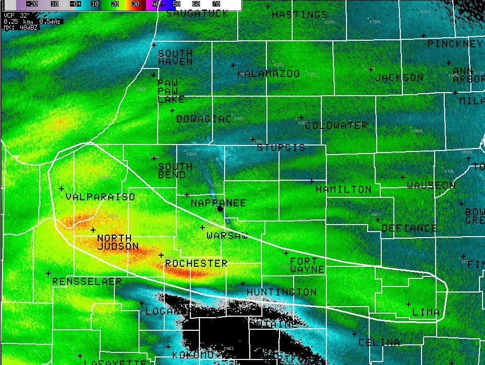
The following radar image from 7pm EST Friday indicates the most significant band of snow (encircled in white) to affect the area in the evening. Note the sharp cutoff in the radar returns to the south of this band. This banded nature of the snow is quite common when a strong low level frontal boundary is present, which was the case in this event.
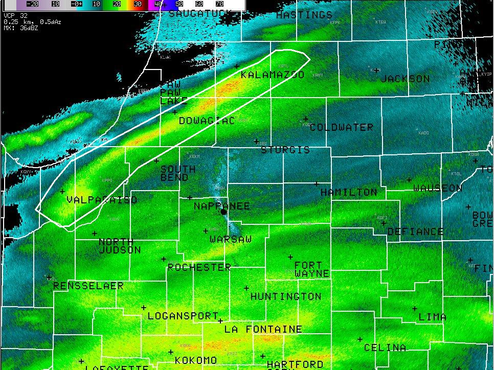
The next radar image is from approximately 3 hours later at 10pm EST. The original band weakened, but another area of enhanced snow developed to the south of the original band. Further to the north, another narrow band of moderate snow developed from northern Laporte county into southwest lower Michigan. Isolated locations across southwest lower Michigan reported storm total snowfall amounts near 6 inches.
Warm air surging northward in advance of this system resulted in a sharp north to south cutoff in snow accumulation. Freezing rain was reported further to the south across much of southern and central Indiana and southern Ohio. Visible satellite imagery from Saturday morning below indicates the southern extent of the snow accumulation across central Illinois. Low clouds are obscuring the view further east, but this border of snow and no snow extends eastward into central Indiana. Northeast winds behind this system also produced lake effect snow showers on Saturday across mainly northeast Illinois.

The map below includes an analysis of snowfall from the reports of cooperative and COCORAHS observers (some local storm reports not included in the analysis). A list of local storm reports including storm total snowfall reports is also provided:
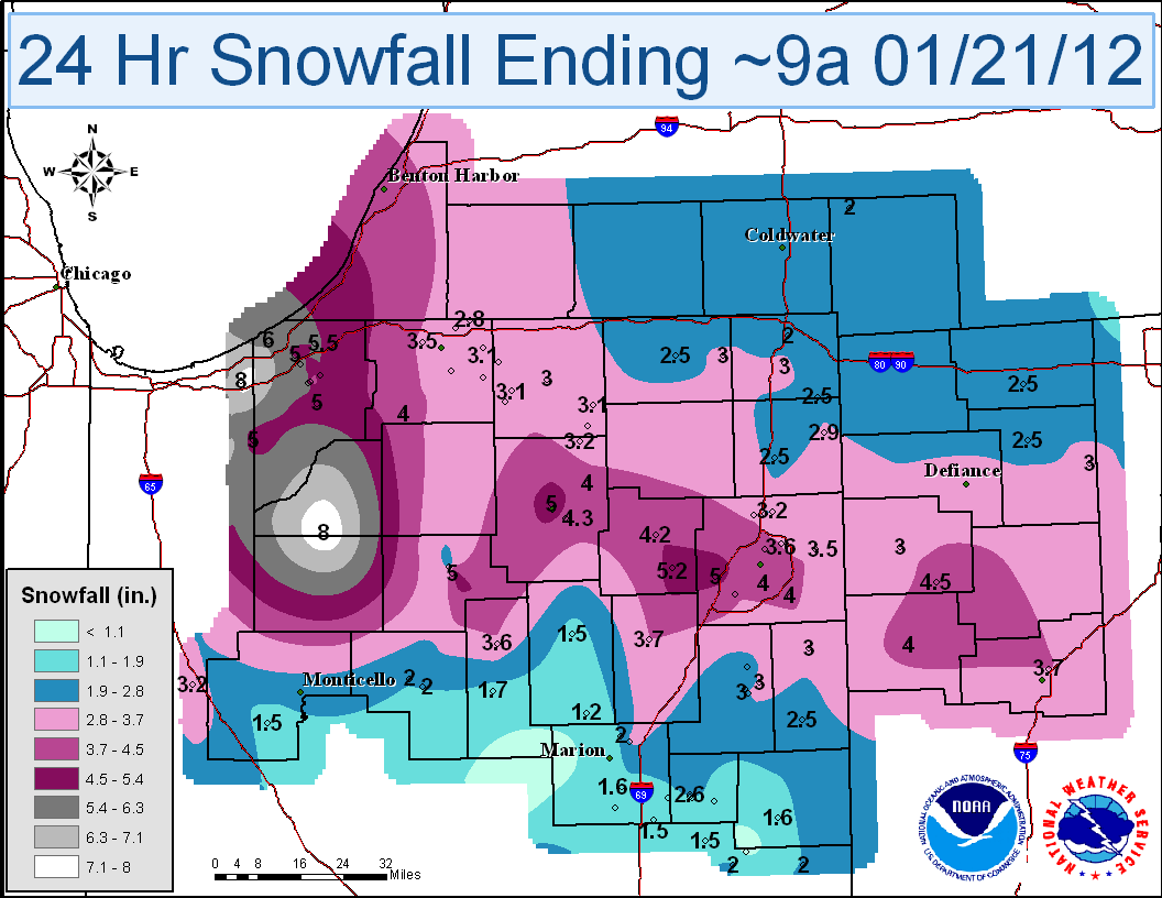
********************STORM TOTAL SNOWFALL********************
LOCATION STORM TOTAL TIME/DATE COMMENTS
SNOWFALL OF
/INCHES/ MEASUREMENT
INDIANA
...ADAMS COUNTY...
DECATUR 6.0 915 AM 1/21 STORM SNOW TOTAL
...ALLEN COUNTY...
7 WSW FORT WAYNE 5.0 800 AM 1/21 STORM SNOW TOTAL
MONROEVILLE 5.0 1021 AM 1/21 STORM SNOW TOTAL
3 NW HOAGLAND 4.0 1000 PM 1/20
3 E WALLEN 3.7 1040 PM 1/20
3 ESE HUNTERTOWN 3.5 700 AM 1/21 STORM SNOW TOTAL
7 N FORT WAYNE 3.3 1000 PM 1/20
5 SW FORT WAYNE 2.8 700 PM 1/20
FORT WAYNE 1.6 659 PM 1/20
...ELKHART COUNTY...
WSW WAKARUSA 3.2 700 AM 1/21 STORM SNOW TOTAL
5 SW ELKHART 3.2 700 AM 1/21 STORM SNOW TOTAL
1 SW MILLERSBURG 2.8 1145 PM 1/20
JIMTOWN 2.3 708 PM 1/20
...FULTON COUNTY...
AKRON 5.0 1103 AM 1/21 STORM SNOW TOTAL
...KOSCIUSKO COUNTY...
2 N NORTH WEBSTER 5.7 700 AM 1/21 STORM SNOW TOTAL
2 SSW WARSAW 5.0 500 AM 1/21 STORM SNOW TOTAL
PIERCETON 5.0 755 AM 1/21 STORM SNOW TOTAL
3 SE WARSAW 4.1 1039 PM 1/20
...LA PORTE COUNTY...
1 SSW MICHIGAN CITY 6.0 600 AM 1/21 STORM SNOW TOTAL
3 NW LAPORTE 5.5 700 AM 1/21 STORM SNOW TOTAL
1 E LAPORTE 5.4 700 AM 1/21 STORM SNOW TOTAL
...LAPORTE COUNTY...
LAPORTE 5.6 935 PM 1/20
KINGSFORD HEIGHTS 5.0 952 PM 1/20
...MARSHALL COUNTY...
PLYMOUTH 4.0 837 PM 1/20
...NOBLE COUNTY...
AVILLA 2.0 930 PM 1/20
...ST. JOSEPH COUNTY...
1 E SOUTH BEND 4.1 949 PM 1/20
6 ENE WALKERTON 4.0 800 AM 1/21 STORM SNOW TOTAL
6 SE MISHAWAKA 3.7 600 AM 1/21 STORM SNOW TOTAL
3 W GRANGER 3.4 800 AM 1/21 STORM SNOW TOTAL
5 SSW OSCEOLA 3.2 831 PM 1/20
2 SE GEORGETOWN 3.1 930 PM 1/20
GRANGER 2.7 935 PM 1/20
4 NNW WOODLAND 2.5 545 PM 1/20
4 NW SOUTH BEND 2.4 700 PM 1/20
...STARKE COUNTY...
6 ESE NORTH JUDSON 8.0 700 AM 1/21 STORM SNOW TOTAL
...STEUBEN COUNTY...
4 N ANGOLA 2.0 630 AM 1/21 STORM SNOW TOTAL
...WHITLEY COUNTY...
N SOUTH WHITLEY 6.5 700 AM 1/21 STORM SNOW TOTAL
COLUMBIA CITY 5.2 650 AM 1/21 STORM SNOW TOTAL
MICHIGAN
...BERRIEN COUNTY...
BUCHANAN 6.0 637 AM 1/21 STORM SNOW TOTAL
2 SSE STEVENSVILLE 3.0 1000 PM 1/20
SAINT JOSEPH 3.0 809 PM 1/20
BENTON HARBOR 2.5 1139 PM 1/20
...HILLSDALE COUNTY...
LITCHFIELD 1.4 905 PM 1/20
OHIO
...ALLEN COUNTY...
LIMA 3.5 1123 PM 1/20
...DEFIANCE COUNTY...
DEFIANCE 3.0 230 AM 1/21 STORM SNOW TOTAL
1 S DEFIANCE 2.0 1010 PM 1/20
...HENRY COUNTY...
MCCLURE 1.8 840 PM 1/20
...PUTNAM COUNTY...
PANDORA 5.1 119 AM 1/21 STORM SNOW TOTAL
COLUMBUS GROVE 3.7 1028 PM 1/20
...VAN WERT COUNTY...
VAN WERT 4.0 1001 PM 1/20
CONVOY 3.8 930 PM 1/20
...WILLIAMS COUNTY...
BRYAN 3.0 1047 PM 1/20
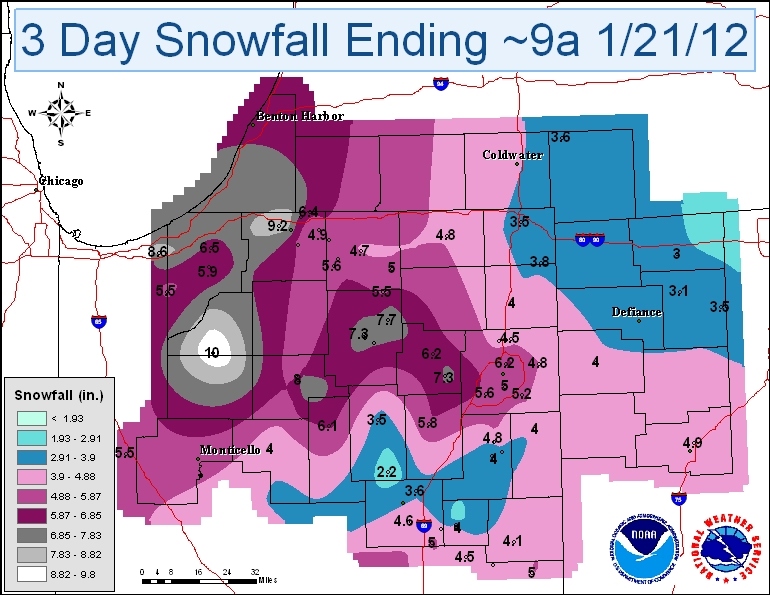
An additional map also depicts the 3-day snowfall totals (Wednesday through Friday) for the area. 3 day totals range from localized 10 inch amounts in northwest and portions of north central Indiana, to around 3 inches across extreme northwest Ohio.
Thanks to all cooperative observers, COCORAHS observers, media, trained spotters, emergency managers, and the public for snowfall reports over the past few days!

