Rain changed to snow after a brief period of sleet Tuesday afternoon. The snow become heavy during the afternoon before ending Tuesday night. The heaviest snow fell generally along and either side of a Logansport to Angola line, where 6 to as many as 10 inches of snow were reported. Numerous reports of accidents and slide-offs were recieved with numerous power outages from the wet heavy snow accumulating on power lines and trees.
Below is a visible image taken from the GOES-13 satellite at 1831Z on Wednesday 11/30/2011. The image shows a swath of snow cover from just northwest of Indianapolis northeastward into the thumb of Michigan, as well as another swath of snow and clouds from Shelbyville northeastward to Lima. This image shows the very sharp gradient of snowfall across northern Indiana, where little to no snow fell near South Bend, and up to 8 to 10 inches fell from Peru to Warsaw to Lagrange to Jonesville!

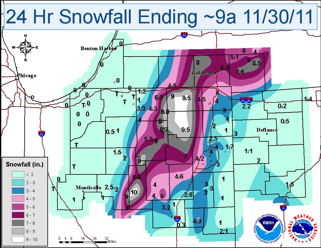
The map below shows snowfall totals from Tuesday. (Click on map for bigger image)
UPDATED SNOWFALL TOTALS FROM NOVEMBER 29 2011 SNOW STORM.

********************STORM TOTAL SNOWFALL********************

LOCATION          STORM TOTAL     TIME/DATE   COMMENTS
                     SNOWFALL           OF
                     /INCHES/   MEASUREMENT

INDIANA

...ALLEN COUNTY...
   5 SW FORT WAYNE        4.4   125 AM 11/30
   4 NE FORT WAYNE        4.0   700 AM 11/30  STORM TOTAL
   5 NE FORT WAYNE        3.2   913 PM 11/29
   MONROEVILLE            2.5   612 AM 11/30
   SSW HUNTERTOWN         1.5   605 PM 11/29

...BLACKFORD COUNTY...
   4 ESE HARTFORD CITY    4.3   800 AM 11/30  24 HOUR TOTAL

...CASS COUNTY...
   ONWARD                 9.0  1100 PM 11/29
   GALVESTON              7.0  1100 PM 11/29
   1 N LOGANSPORT         2.5  1100 PM 11/29

...DEKALB COUNTY...
   NNE BUTLER             4.0   700 AM 11/30  STORM TOTAL

...ELKHART COUNTY...
   MILLERSBURG            8.8   950 PM 11/29
   NEW PARIS              5.0   657 PM 11/29
   NAPPANEE               3.0   801 PM 11/29
   1 E NAPPANEE           3.0   632 PM 11/29

...FULTON COUNTY...
   AKRON                  9.0   307 AM 11/30

...GRANT COUNTY...
   MARION                 5.0   624 PM 11/29

...HUNTINGTON COUNTY...
   3 SW ANDREWS           6.0   545 PM 11/29
   HUNTINGTON             5.0   602 PM 11/29
   W HUNTINGTON           4.6   700 AM 11/30  STORM TOTAL

...KOSCIUSKO COUNTY...
   NORTH WEBSTER          9.0   920 PM 11/29
   2 N NORTH WEBSTER      8.7  1157 PM 11/29
   SYRACUSE               8.0  1217 AM 11/30  STORM TOTAL SNOWFALL.
   WARSAW                 7.5   937 PM 11/29
   2 NE WARSAW            7.2   815 PM 11/29
   2 NNE OSWEGO           7.2   920 PM 11/29
   1 N MILFORD            7.0   904 PM 11/29
   2 SW NORTH WEBSTER     6.6   700 AM 11/30  STORM TOTAL
   5 NE WARSAW            6.0   830 PM 11/29
   1 NNW WARSAW           5.5   930 PM 11/29

...LAGRANGE COUNTY...
   1 ENE LAGRANGE         9.5   700 AM 11/30  STORM TOTAL
   SHIPSHEWANA            9.0  1100 PM 11/29

...MIAMI COUNTY...
   2 SW PERU             10.0   857 PM 11/29  UPDATED STORM TOTAL
   1 NE DENVER            6.8   900 AM 11/30  STORM TOTAL

...STEUBEN COUNTY...
   4 NNW HUDSON           4.5   611 AM 11/30
   4 N ANGOLA             4.0   536 AM 11/30

...WABASH COUNTY...
   1 NW LA FONTAINE       6.0   900 AM 11/30  STORM TOTAL
   NNW WABASH             4.0   700 AM 11/30  STORM TOTAL

...WELLS COUNTY...
   3 ENE BLUFFTON         3.0   700 AM 11/30  STORM TOTAL

...WHITLEY COUNTY...
   7 SSE COLUMBIA CITY    7.0   700 AM 11/30  STORM TOTAL
   COLUMBIA CITY          6.3   954 PM 11/29  UPDATED TOTAL

MICHIGAN

...BRANCH COUNTY...
   SHERWOOD               8.0  1004 PM 11/29
   5 NNE SHERWOOD         4.0   851 PM 11/29

...HILLSDALE COUNTY...
   9 E JONESVILLE         8.5  1145 PM 11/29
   6 ENE JONESVILLE       6.0   700 AM 11/30  STORM TOTAL
   LITCHFIELD             2.1   800 PM 11/29
   JONESVILLE             2.0   845 PM 11/29  ROADS ARE SLUSHY.

...ST. JOSEPH COUNTY...
   3 S COLON              7.5   512 AM 11/30

OHIO

...ALLEN COUNTY...
   LIMA                   1.5   948 PM 11/29  RELAYED BY NWS ILN

...PUTNAM COUNTY...
   COLUMBUS GROVE         0.8   613 AM 11/30

...VAN WERT COUNTY...
   VAN WERT               2.3   900 AM 11/30  EVENT TOTAL SNOW

$$
In addition to the heavy snow, periods of heavy rain over the past several days caused many rivers to flood. The worst flooding conditions included northeast Indiana and northwest Ohio where widespread rainfall ranged from 3 to 5 inches with local amounts in excess of 6 inches.
The map below shows 2 day rainfall totals beginning at 9 am 11/28/2011 through 9 am 11/30/2011. (Click on map for bigger image)


