Northern Indiana
Weather Forecast Office
An outflow boundary from morning convection was the focus for thunderstorm development across the area. It moved from Illinois into the area by the early afternoon hours. Daytime heating allowed for moderate instability to develop across the County Warning Area (CWA). This combined with an area of convergence was enough to develop scattered thunderstorms, some of which became severe rather rapidly. These storms produced heavy rainfall and wind damage across the CWA.
Damage Survey of Warsaw/Winona Lake
A survey of damage was performed across the Warsaw/Winona Lake area. In addition, video footage and eyewitness accounts were reviewed. A funnel was observed on the leading edge of the storm. However, the damage across the area indicates a touchdown did not occur. Damage in the area started in the southwest parts of Warsaw and then spread out to affect much of the southern part of Warsaw into the town of Winona Lake. Other than some minor roof damage to a few businesses, structural damage was minimal. However, several "paths" of tree damage was found. This is consistent with a downburst. Winds were estimated at 85 to 90 mph.
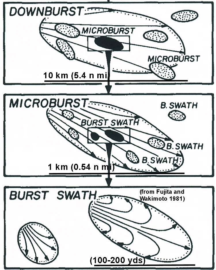
Fig. 1 Graphical Illustrations of a Downburst, a number of Microburst embedded within a Downburst, and a number of Burst Swaths embedded within a Microburst. Note the divergent characteristics with each of these wind phenomena (Courtesy Fujita and Wakimoto 1981).
Definition of a Downburst: A strong downdraft which induces an outburst of damaging winds on or near the surface. A family of downburst is called a "downburst cluster" or collection of downburst having overall lengths of over 50 to 60 n miles. The overall size of an individual downburst can vary from 4 to 6 n miles. The damage pattern at the surface is 'highly divergent.' Several microburst can be identified within an individual downburst. We have seen and documented this damging wind pattern in a number of cases. During his studies in the mid 1970s most downburst winds (47%) fell into the category of F0 (traditional Fujita scale) which means that estimated wind speeds varied from 40 to 72 mph. About (32%) of the downburst reached F1 category with wind speeds varying from 73 to 112 mph. About 20% of the downburst cases reached or exceeded F2 intensity.
Definition of a Microburst: A strong downdraft which induces an outburst of damaging winds over an area from 1/2 to 1 statue mile. The life time of a microburst is less than 20 minutes. Several microbursts can occur within a downburst as shown in the middle figure above.
Definition of Burst Swath: is defined as extreme wind occurring within a microburst. A long narrow burst swath can often resemble a path of a tornado, however the corn or tree pattern within a burst swath is highly divergent. Burst swaths can range to 50 to 150 yards long.
The following is a summary of local storm reports we received.
PRELIMINARY LOCAL STORM REPORT...SUMMARY
NATIONAL WEATHER SERVICE NORTHERN INDIANA
444 PM EDT FRI JUL 22 2011

..TIME...   ...EVENT...      ...CITY LOCATION...     ...LAT.LON...
..DATE...   ....MAG....      ..COUNTY LOCATION..ST.. ...SOURCE....
            ..REMARKS..

0100 PM     TSTM WND DMG     ANGOLA                  41.64N  85.00W
07/22/2011                   STEUBEN            IN   TRAINED SPOTTER

            NUMEROUS TREES AND BRANCHES REPORTED DOWN IN ANGOLA.
            TIME ESTIMATED FROM RADAR.

0110 PM     TSTM WND DMG     N WINAMAC               41.05N  86.60W
07/22/2011                   PULASKI            IN   TRAINED SPOTTER

            MULTIPLE TREES UPROOTED AND BRANCHES DOWN ON THE NORTH
            SIDE OF WINIMAC. ESTIMATED WIND GUSTS OF 60-70 MPH.

0115 PM     TSTM WND GST     METZ                    41.62N  84.84W
07/22/2011  M56 MPH          STEUBEN            IN   EMERGENCY MNGR

0118 PM     TSTM WND GST     2 S NAPOLEON            41.36N  84.13W
07/22/2011  E70 MPH          HENRY              OH   TRAINED SPOTTER

            ALSO LARGE LIMBS DOWN AND 1.33 INCHES OF RAIN IN 20
            MINUTES

0130 PM     TSTM WND DMG     ARGOS                   41.70N  86.25W
07/22/2011                   MARSHALL           IN   EMERGENCY MNGR

            TREE DOWN AT JUNIPER RD AND SR 10 AND TREE ON POWER
            LINE ON SYDNEY ROAD

0136 PM     TSTM WND DMG     BASS LAKE               41.21N  86.60W
07/22/2011                   STARKE             IN   EMERGENCY MNGR

            *** 1 INJ *** TREE FELL ONTO HOUSE AT STATE ROAD 10 AND
            COUNTY ROAD 600 IN BASS LAKE.

0137 PM     TSTM WND GST     2 NE MONTPELIER         41.60N  84.58W
07/22/2011  E50 MPH          WILLIAMS           OH   TRAINED SPOTTER

            SLIGHTLY LESS THAN HALF INCH HAIL AND HEAVY RAIN
            REPORTED AS WELL.

0200 PM     TSTM WND DMG     WARSAW                  41.24N  85.85W
07/22/2011                   KOSCIUSKO          IN   TRAINED SPOTTER

            TREES DOWN AND POWER OUT

0200 PM     TSTM WND DMG     1 NW WARSAW             41.25N  85.87W
07/22/2011                   KOSCIUSKO          IN   AMATEUR RADIO

            TREE DOWN ACROSS FOX FARM ROAD

0205 PM     TSTM WND DMG     WARSAW                  41.24N  85.85W
07/22/2011                   KOSCIUSKO          IN   LAW ENFORCEMENT

            POWER LINES DOWN ON CENTER AND MAIN ST

0208 PM     TSTM WND GST     2 N NORTH WEBSTER       41.36N  85.70W
07/22/2011  E60 MPH          KOSCIUSKO          IN   NWS OFFICE

0215 PM     TSTM WND GST     SOUTH WHITLEY           41.08N  85.63W
07/22/2011  E60 MPH          WHITLEY            IN   EMERGENCY MNGR

            SMALL TO MEDIUM BRANCHES FALLING AS WELL.

0215 PM     TSTM WND DMG     S SOUTH WHITLEY         41.08N  85.63W
07/22/2011                   WHITLEY            IN   EMERGENCY MNGR

            POWER LINE DOWN ACROSS SR 105 SOUTH OF SOUTH WHITLEY.
            TIME ESTIMATED FROM RADAR.

0227 PM     FLASH FLOOD      S ASHLEY                41.53N  85.07W
07/22/2011                   DEKALB             IN   STATE POLICE

            WATER PONDING ON I69

0227 PM     TSTM WND GST     4 S COLUMBIA CITY       41.10N  85.49W
07/22/2011  E60 MPH          WHITLEY            IN   TRAINED SPOTTER

            ESTIMATED 60 MPH GUST ASSOCIATED WITH OUTFLOW

0230 PM     TSTM WND DMG     1 NW ANDREWS            40.87N  85.62W
07/22/2011                   HUNTINGTON         IN   EMERGENCY MNGR

            TREE ACROSS ROAD ON SR 105 JUST NORTH OF US 24. TIME
            ESTIMATED FROM RADAR

0230 PM     TSTM WND DMG     AUBURN                  41.37N  85.06W
07/22/2011                   DEKALB             IN   LAW ENFORCEMENT

            TREES AND POWER LINES DOWN

0230 PM     TSTM WND DMG     ARCHBOLD                41.52N  84.31W
07/22/2011                   FULTON             OH   LAW ENFORCEMENT

            TREES...POWER POLES...AND POWER LINES DOWN IN ARCHBOLD
            AND SW PART OF COUNTY

0239 PM     TSTM WND DMG     1 W FORT WAYNE          41.07N  85.16W
07/22/2011                   ALLEN              IN   LAW ENFORCEMENT

            POWER LINES DOWN AT GARDEN ST AND WASHINGTON BLVD FROM
            OUTFLOW BOUNDARY

0245 PM     TSTM WND DMG     GRABILL                 41.21N  84.97W
07/22/2011                   ALLEN              IN   LAW ENFORCEMENT

            TREES AND POWER LINES DOWN IN NORTHERN PORTION OF ALLEN
            COUNTY

0300 PM     HEAVY RAIN       2 N NORTH WEBSTER       41.36N  85.70W
07/22/2011  M1.60 INCH       KOSCIUSKO          IN   NWS OFFICE

            1.60 INCHES OF RAINFALL IN THE PAST ONE HOUR AND
            FIFTEEN MINUTES.

0313 PM     TSTM WND DMG     1 N TIPTON              41.04N  84.67W
07/22/2011                   PAULDING           OH   EMERGENCY MNGR

            POWER LINES DOWN ON CR 71. TIME ESTIMATED FROM RADAR

0330 PM     TSTM WND DMG     PETTISVILLE             41.53N  84.23W
07/22/2011                   FULTON             OH   LAW ENFORCEMENT

            TREES DOWN

0404 PM     TSTM WND GST     1 NW YODER              40.70N  84.08W
07/22/2011  E60 MPH          ALLEN              OH   TRAINED SPOTTER

            BLOWING DUST REDUCED VISIBILITY TO NEAR ZERO AT TIMES.
            TRAFFIC STOPPED ON INTERSTATE 75. TIME ESTIMATED FROM
            RADAR

0407 PM     TSTM WND GST     3 NE YODER              40.71N  84.03W
07/22/2011  M69 MPH          ALLEN              OH   ASOS

            MEASURED 60 KT GUST AT KAOH ASOS
OBERGFELL/MURPHY/FISHER
Hazards
Heat Related
Winter Related
Watch/Warning
Outlook
Storm Reports
Storm Prediction Center
Submit a Report
Event Ready
Climate
FWA Daily
SBN Daily
FWA Monthly
SBN Monthly
CoCoRaHS
Spring Frost Climatology
Fall Frost Climatology
Severe Climatology
Local Information
Skywarn
COOP
Our Office
WSR-88D
Headline Criteria
NOAA Weather Radio
Weather History
Probabilistic Snowfall
Public Information Statement
Social Media Feeds
Weather Events Page
US Dept of Commerce
National Oceanic and Atmospheric Administration
National Weather Service
Northern Indiana
7506 E 850 N
Syracuse, IN 46567
574-834-1104
Comments? Questions? Please Contact Us.

