FEBRUARY 1st BLIZZARD
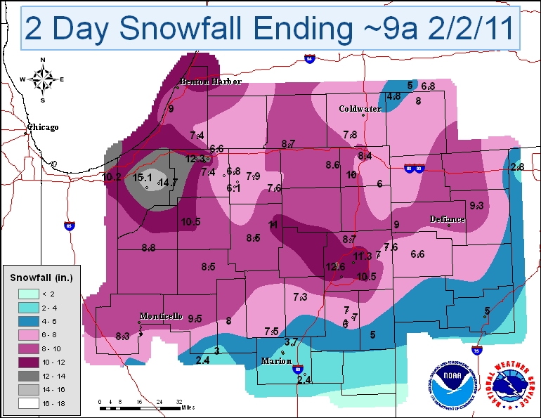
A quick-hitting blizzard affected much of northwest Ohio, northern Indiana, and southwest Lower Michigan during the late afternoon and evening hours of February 1st. This system began as a potent upper level disturbance across the Southern Plains that ejected northeastward towards the Middle Mississippi Valley and Southern Great Lakes. Impressive lift with this negatively tilted trough led to rapid cyclogenesis during the morning hours of February 1st across the Lower Mississippi River Valley, with continued deepening as the surface low tracked north-northeast into east-central Illinois by late in the evening. Moderate to heavy precipitation rapidly spread into the forecast area during the mid to late afternoon hours. Precipitation began as mainly snow north of Highway 24, with a mixture of snow and sleet along and south of Highway 24 due to a warm layer aloft. This warm layer filtered northward during the evening which allowed the heavy snow to change over to sleet north of Highway 24. A strong surface pressure gradient between the aforementioned surface low and a 1050 mb arctic high pressure system across the Plains created strong winds during the height of the storm. Sustained winds generally ranged between 30 and 40 mph in the evening, with gusts between 40 and 55 mph. This combined with the heavy snow and sleet created blizzard conditions, especially along and north of Highway 24, where visibilities were reduced to less than an eighth of a mile for several hours early in the evening. The mixed precipitation and strong winds abruptly came to an end during the overnight hours as low pressure tracked into northern Indiana and a dry slot moved into the area.
| LOCATION | SNOW TOTALS | LOCATION | SNOW TOTALS | |
| Portage 0.9 ESE | 15.7 | Jonesville 5.9 ENE | 8.0 | |
| La Porte 1.6 SW | 15.1 | Peru | 8.0 | |
| Kingsbury 5.0 ENE | 14.7 | Goshen 1.9 NW | 7.9 | |
| South Bend 2 NE | 14.5 | Bronson 5.9 SE | 7.8 | |
| Hebron 3.7 NE | 13.2 | Millersburg 0.5 SW | 7.6 | |
| Fort Wayne 5.4 WSW | 12.6 | Granger 2.9 W | 7.6 | |
| South Bend Airport | 12.3 | Woodburn 3 N | 7.6 | |
| Valparaiso 5.7 WSW | 12.1 | Wakarusa 2.4 NNE | 7.5 | |
| North Webster 2 SW | 11.0 | Niles 2.7 W | 7.4 | |
| Plymouth 2.5 WSW | 10.5 | Huntington 0.3 W | 7.3 | |
| Valparaiso 1.8 NW | 10.4 | Woodburn 2.8 WSW | 7.0 | |
| Fort Wayne Airport | 10.2 | Bluffton 0.9 SE | 7.0 | |
| Leesburg 6.7 ESE | 10.2 | Brooklyn 2 ENE | 6.8 | |
| Chesterton 4.2 E | 10.2 | Elkhart 3.1 SSE | 6.8 | |
| Hudson 4.1 NNW | 10.0 | Paulding | 6.6 | |
| Rensselar | 9.8 | Bluffton 1 N | 6.0 | |
| Logansport 1.7 ENE | 9.5 | Hamilton 1.7 E | 6.0 | |
| Napoleon | 9.3 | Attica 3.4 SSW | 5.5 | |
| Hicksville | 9.0 | Lafayette 2.2 S | 5.5 | |
| Stevensville 1.7 SSE | 9.0 | Berne 0.8 WSW | 5.0 | |
| North Judson 5.7 ESE | 8.8 | Lima 2.7 NE | 5.0 | |
| Huntertown 2.6 ESE | 8.7 | Litchfield 0.3 ENE | 4.8 | |
| White Pigeon 3.4 ESE | 8.7 | Atlanta 4.4 W | 4.5 | |
| LaGrange 9.9 E | 8.6 | Marion 5.4 NNE | 3.7 | |
| Warsaw Airport | 8.5 | Kokomo 6.8 W | 3.6 | |
| Rochester | 8.5 | Covington 0.4 WNW | 2.8 | |
| Angola 4.1 N | 8.4 | Upland 2.4 SSE | 2.4 | |
| Chalmers 5W | 8.3 |
*The values listed in this table were snowfall totals given at roughly ~9am on Wednesday, February 2nd.
Additional snow has fallen since 9am on Wednesday morning and is not accounted for in this table or the map.
Peak Wind Gusts Reported
PUBLIC INFORMATION STATEMENT
NATIONAL WEATHER SERVICE NORTHERN INDIANA
947 AM EST WED FEB 2 2011 /847 AM CST WED FEB 2 2011/

WIND INFORMATION FOR THE PAST 24 HOURS...

LOCATION             HIGHEST OB TIME WIND   PEAK WIND OR
                          AND OB TIME            PEAK OB TIME GUST

INDIANA...

AUBURN                    33 MPH / 1023 PM       47 MPH / 1103 PM
FORT WAYNE                40 MPH /  954 PM       54 MPH /  913 PM
GOSHEN                    26 MPH / 1040 PM       43 MPH / 1035 PM
GRISSOM AFB               40 MPH /  807 PM       52 MPH /  855 PM
KNOX                      33 MPH /  845 PM       47 MPH /  745 PM
ROCHESTER                 31 MPH /  845 PM       41 MPH /  845 PM
SOUTH BEND                24 MPH /  954 PM       41 MPH /  943 PM
WARSAW                    36 MPH / 1025 PM       46 MPH / 1045 PM


MICHIGAN...

BENTON HARBOR             22 MPH /  553 PM       36 MPH /  706 PM
COLDWATER                 30 MPH /  934 PM       41 MPH / 1034 PM
HILLSDALE                 37 MPH /  955 PM       48 MPH / 1134 PM
STURGIS                   35 MPH /  854 PM       44 MPH / 1115 PM
THREE RIVERS              26 MPH / 1015 PM       35 MPH / 1015 PM


OHIO...

DEFIANCE                  29 MPH / 1001 PM       43 MPH /  959 PM
LIMA                      35 MPH /  553 AM       52 MPH /  549 AM
Photos
Images from the North Webster and Leesburg areas in Indiana:
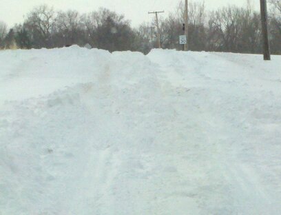
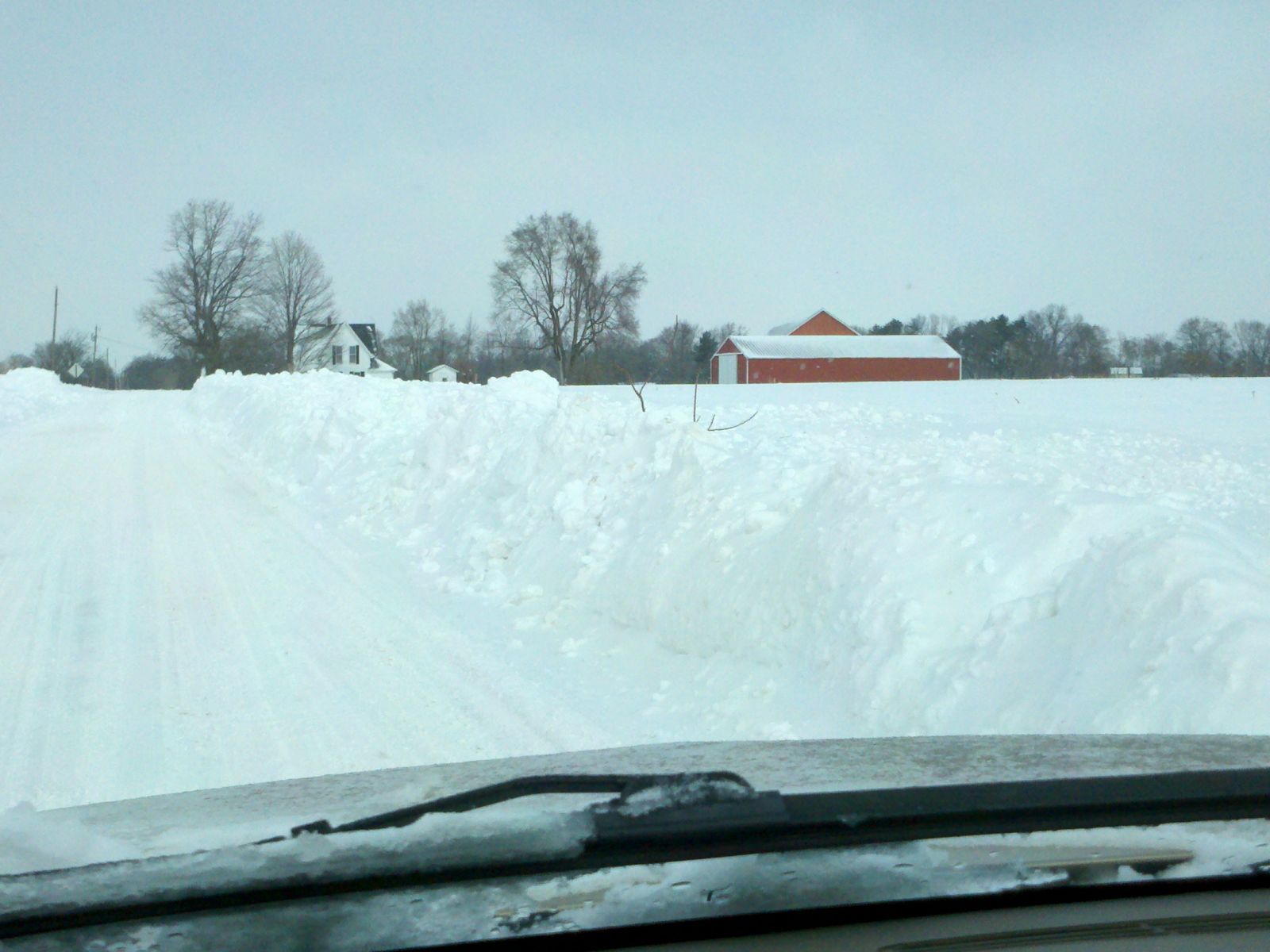
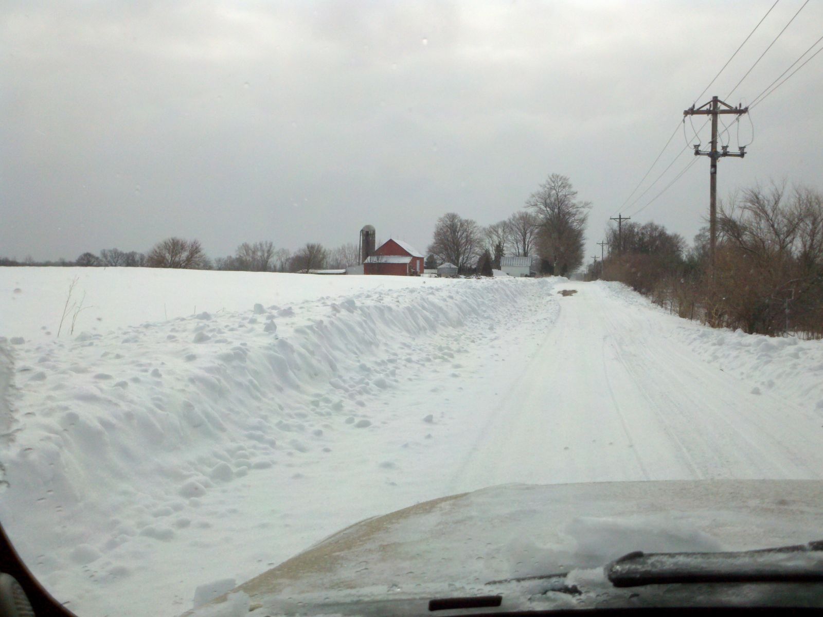
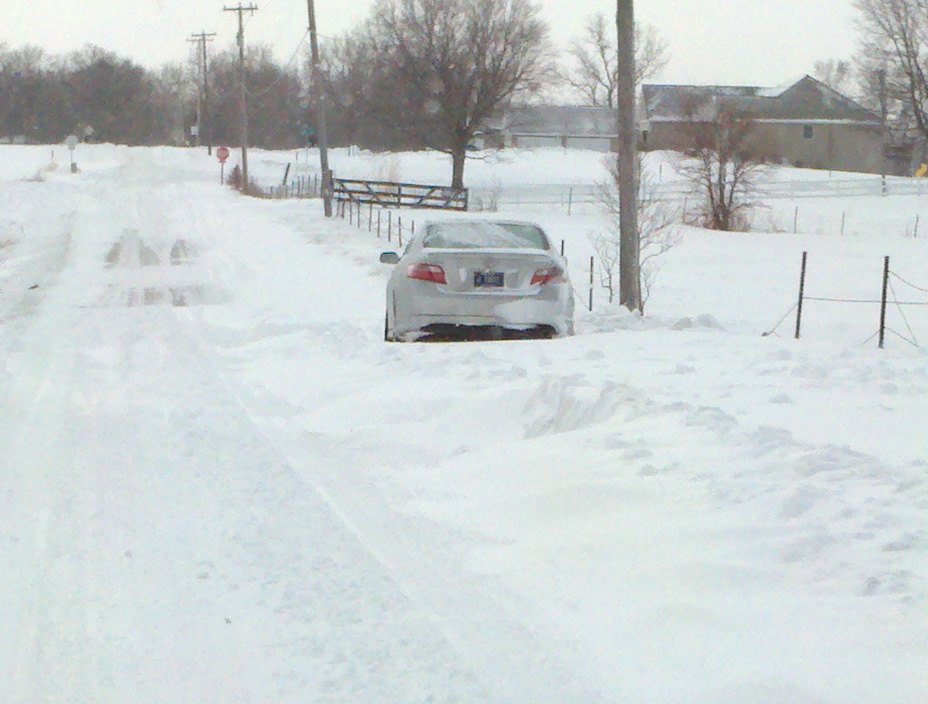
Image taken just west of Hoagland, IN
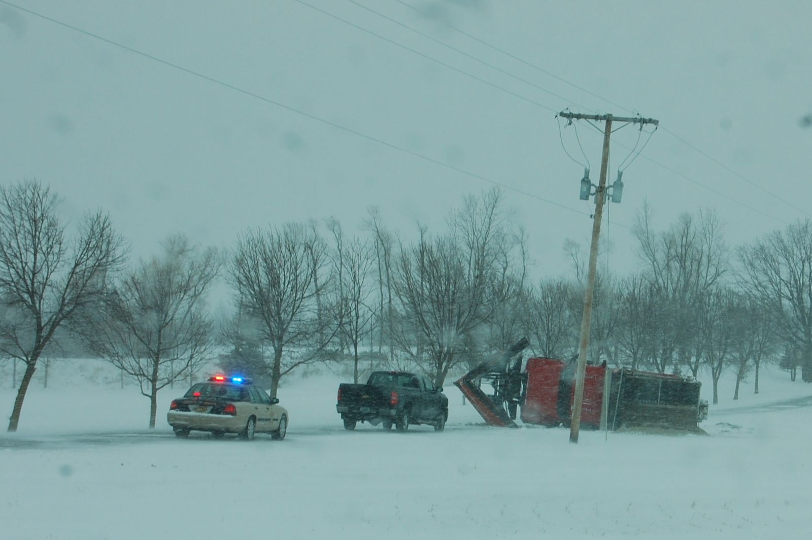
(Photo courtesy of Jim Koch)
WEISSER / STEINWEDEL

