Northern Indiana
Weather Forecast Office
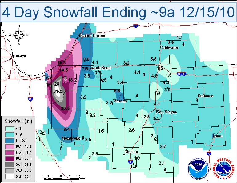
Below is a table highlighting the highest snowfall amounts for this event.
| LOCATION | SNOW AMT | LOCATION | SNOW AMT | |
| Wanatah 4.4 ESE | 31.5 | South Bend 4.6 SE | 8.2 | |
| Westville 4.7 ESE | 28.0 | Leesburg 6.7 ESE | 7.2 | |
| La Porte 1.6 SW | 24.7 | Porter 0.6 S | 7.1 | |
| North Judson 5.7 ESE | 20.5 | Valparaiso 5.7 WSW | 7.1 | |
| Valparaiso 3.9 ENE | 19.0 | Syracuse 0.9 SW | 6.8 | |
| Kingsbury 5.0 ENE | 18.2 | Crown Point 7.8 E | 6.7 | |
| Valparaiso 0.4 SSW | 17.1 | Hebron 3.7 NE | 6.2 | |
| Valparaiso 1.4 ENE | 15.9 | Valparaiso 1.8 NW | 6.2 | |
| Kingsbury 0.3 WNW | 15.1 | La Porte 2.3 ESE | 6.0 | |
| La Porte 6.2 N | 14.5 | Fort Wayne 7.0 NE | 5.8 | |
| Valparaiso 0.9 NNW | 13.6 | Woodburn 2.8 WSW | 5.6 | |
| La Porte 1.2 E | 13.2 | Munster 0.8 SSE | 5.5 | |
| Lakes Of The Four Seasons 1.5 NNE | 10.0 | Crown Point 1.1 N | 5.5 | |
| Valparaiso 1.4 WNW | 9.9 | Bedford 8.6 NNW | 5.5 | |
| Chesterton 4.2 E | 9.2 | Valparaiso 0.6 SE | 5.5 | |
| Burnettsville 9.9 NNW | 9.1 | Mishawaka 2.5 SE | 5.2 | |
| Valparaiso 4.6 NNE | 8.9 | Fort Wayne 9.1 SE | 5.1 | |
| Valparaiso 2.0 ESE | 8.6 | Carmel 0.9 ESE | 5.1 | |
| Chesterton 1.4 ENE | 8.3 | Logansport 2.2 NNW | 5.0 | |
| Portage 0.9 ESE | 8.2 | LaGrange 7.2 ESE | 5.0 |
| 24 Hour Totals Dec. 12: Mainly system snow amounts | 24 Hour Totals Dec. 13: Lake Effect Snow amounts | |
|---|---|---|
 |
 |
| 24 Hour Totals Dec. 14: Lake Effect Snow amounts | 24 Hour Totals Dec. 15: Lake Effect Snow amounts | |
|---|---|---|
 |
 |
| 3 Day Snowfall Totals as of Tuesday, December 14, 2010 |
|---|
 |
Click on any image to see a larger map.
Below is a picture of downtown La Porte at the height of the storm on December 12th. Notice the limited visibility and blowing snow!
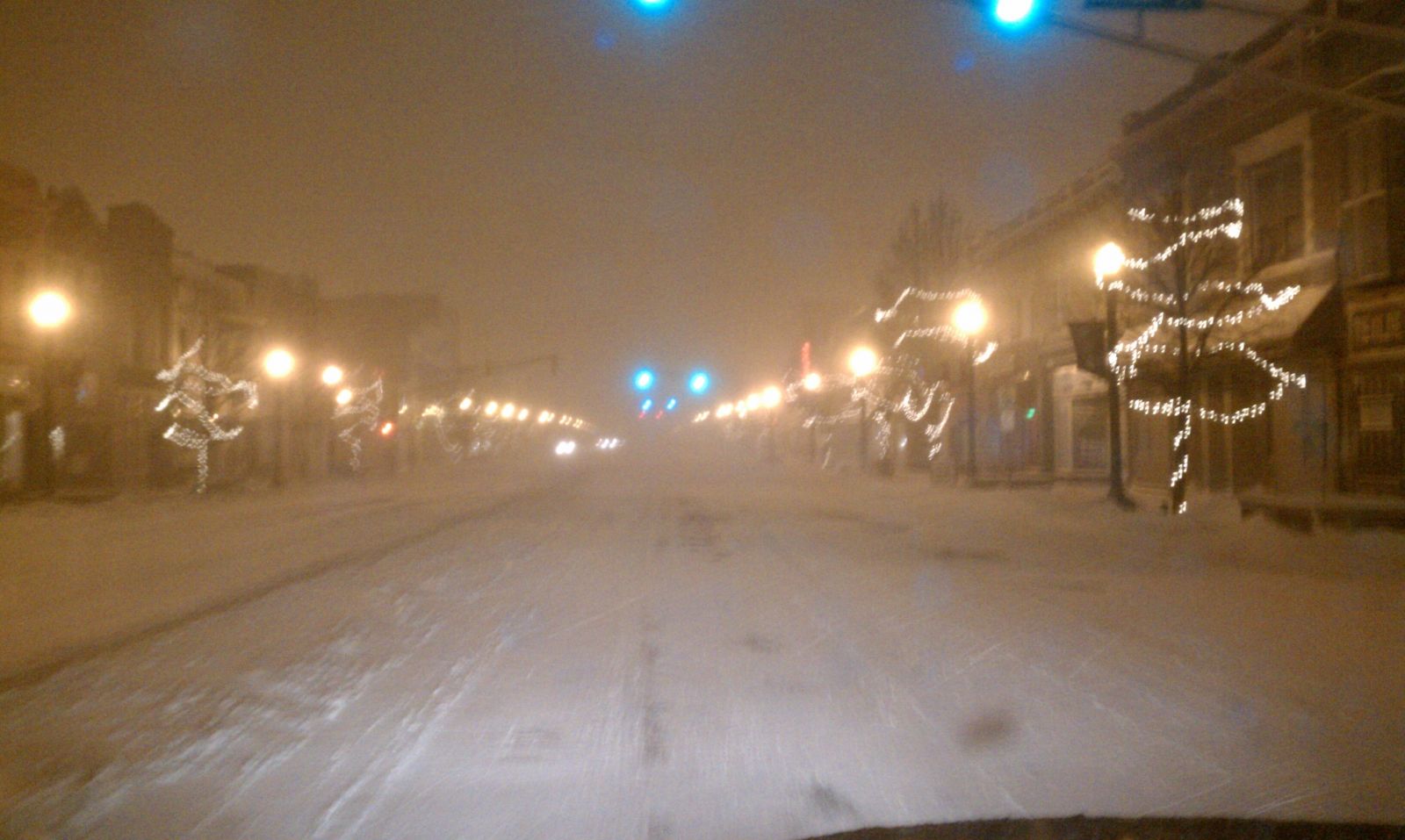 |
| Photo courtesy Joe Vorrier |
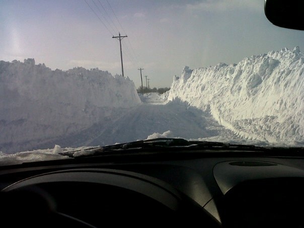
Below are a few photos showing the amount of snow La Porte County where over 30 inches fell in the 3 day period. (Photos courtesy Lori Barrett)
 |
 |
|
| Wanatah - December 13th | Wanatah - December 14th |
 |
| Union Mills - December 14th |
WEISSER/OBERGFELL
Hazards
Heat Related
Watch/Warning
Outlook
Storm Prediction Center
Storm Reports
Submit a Report
Outdoor Event Watcher
EM Briefing
Current Conditions
Hourly Weather
Surface Observations
Regional Temps/Precip
Precip Reports
Satellite
Climate
CoCoRaHS
FWA Daily
SBN Daily
FWA Monthly
SBN Monthly
Cliplot
Spring Frost Climatology
Fall Frost Climatology
Severe Climatology
Tornado Climatology
Local Information
Public Information Statement
Probabilistic Snowfall
Storm Data
Skywarn
COOP
Our Office
WSR-88D
Headline Criteria
NOAA Weather Radio
Weather History
Social Media Feeds
Weather Events Page
US Dept of Commerce
National Oceanic and Atmospheric Administration
National Weather Service
Northern Indiana
7506 E 850 N
Syracuse, IN 46567
574-834-1104
Comments? Questions? Please Contact Us.

