Northern Indiana
Weather Forecast Office
A record-breaking low pressure system over Minnesota pushed a strong cold front through the lower Midwest on October 26, 2010. The associated cold front aided in the development in a line of strong thunderstorms known as a squall line that stretched from northern Wisconsin through Illinois into Missouri during the early morning hours of the 26th. This line of thunderstorms pushed through the Northern Indiana office's county warning area during the morning and early afternoon hours.
The squall line produced widespread wind damage across the Midwest with wind gusts of 50 to 60 mph with some locations recording gusts up to 75 mph! In addition to the strong winds, some of the storms produced tornadoes in Wisconsin, Illinois, Indiana, and Ohio. The image below shows the storm reports as relayed to the Storm Prediction Center from the day. Click on the image below to link to the SPC storm report web page for 10-26.

NWS IWX has confirmed 13 tornadoes in their county warning area (CWA) in northern Indiana and northwestern Ohio.
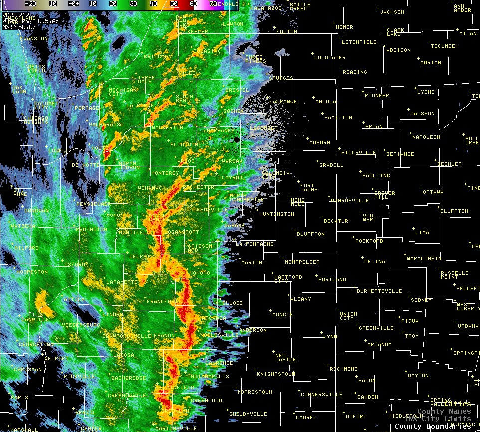
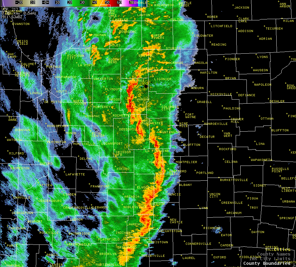
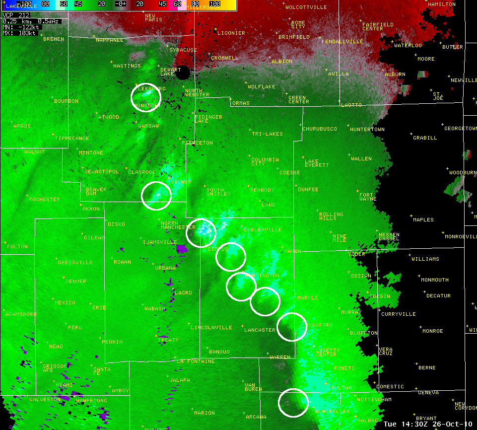
Below is the radar loop of the entire event as the storms moved across the forecast area. In the image below the radar loop, numerous couplets were seen at multiple times along this line. Every couplet circled was possible of producing a tornado and many of these couplets did produce tornadoes at one time or another in several different counties. At this instance or shortly after, both the Kosciusko County EF0 and extreme northwest Huntington County EF1 touched down.

(The loop will take a few moments to load.)
The Synoptic setting...A historically deep low pressure system supported a very sharp surface trough into the Midwest on the morning of the 26th. At 7 am EDT, an anomalously strong upper level jet of 140 knots with an associated 100+ knot mid level jet (approx. 500 mb) was in the process of advecting into the southwest Great Lakes with deep diffluent flow observed. The upper jet had began to curve cyclonically over the Midwest with the divergent left front exit region basically over the western Midwest and coincident with the sfc trough in place. 850 mb flow was observed at over 75 knots with sfc gusts in excess of 45 knots ahead of the sfc trough per warm air advection. The dryline/trough was supporting a line of severe thunderstorms with ongoing reports of damaging winds and a few tornadoes. This system was a perfect text book case of strong cyclogenesis spurred by a powerful upper level jet and associated strong cold air advection with forcing fields lined up perfectly to support mass upper level divergence with low level convergence, in the presence of a negatively tilted upper level trough.
|
|||||||
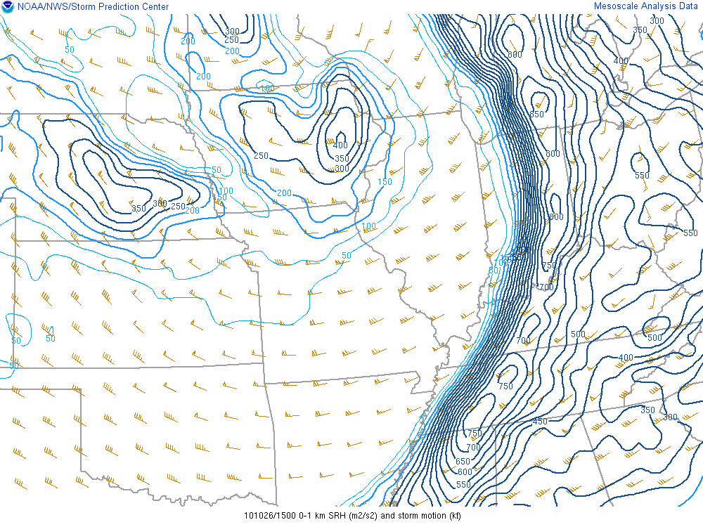
The Mesoscale and Stormscale environment...The mesoscale environment could not have been more dynamic to support severe thunderstorms. By 9 am EDT, a severe line echo wave pattern (LEWP) had developed across southern IN, with a broken line of weaker cells across northern IL into NW IN. One major component this system lacked early on was appreciable convective avaliable potential energy (CAPE), with typically 500 J/kg or less noted. However, backed sfc flow with nearly 50 knots at 1.5 kft, supported very impressive (nearly off the charts) 0-1 km storm relative helicity values with around 500 m2/s2 early on in the event to over 800 m2/s2 by the end of the event. Effective shear (cloud bearing) were more than ample to support strong rotating updrafts (meso/misocyclones) and given the confined low level shear values(0-1km) of over 50 knots with SR helicity of 500-800 m2/s2, it would certainly not take much to produce a tornado as was the case. Even though CAPE parameters were very marginal and pre-squall line lifting condensation level's /level's of free convection were also marginal, one very important thing to note is that much of the CAPE was located in the 0-3 km layer and most certainly the 0-1 km layer, meaning that any low level stretching of ambient vorticity would have been very strong at or around cloud base and very supportive for tornadoes (very similar to the 4-20-04 outbreak). In addition, strong flow just off the sfc per the synoptic fields would have easily mixed down to the ground given the PW fields (column loading) and the addition of any miso/meso-cyclones. Conditions became more supportive for severe damaging winds and tornadoes as the upper level jet neared the region (flow increased) and instability increased per diurnal heating.
|
|||||||
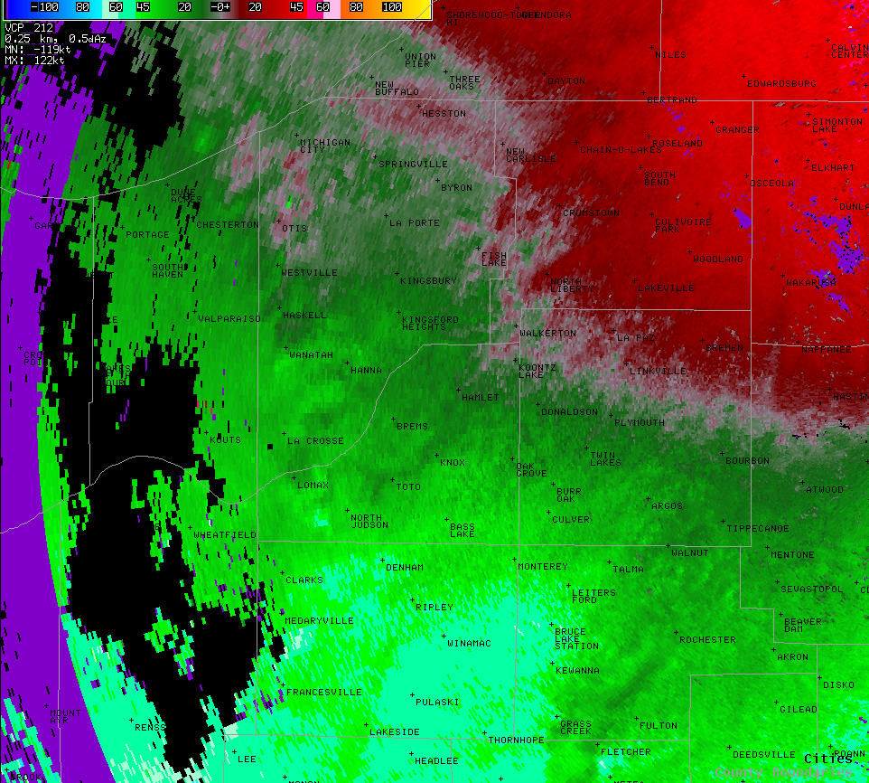
The radar trends and observations...Radar trends were certainly interesting nonetheless. The aforementioned broken line of cells that initially pushed into the forecast area (FA) over the NW, were full of moderate to strong misocylone couplets, most noticeable on the TMDW radar. The same signatures were not as impressive on KLOT leading one to believe that the couplets were based very low in the cells. (TMWD base level is 0.3 while KLOT is 0.5) The couplets developed quickly and were typically short-lived and at any given time 3-5 were observed. Given the dynamic nature and the environment with the above mentioned parameters in place, a tornado warning with squall line mention was used. The line weakened as it pushed NE into the FA, but concerns on whether this was a sampling issue given the proximity to the radar, supported an issuance of another warning given the environment in place. The LEWP advecting NE into the FA contained numerous strong circulation couplets and again given the environment and the parameters in place a TOR warning with squall line mention was issued. The TOR with the squall line mention was preferred given the environment, anomalously strong nature of the system, and numerous transient velocity couplets. Numerous reflectively tags were also observed which is typical given the strong upper jet and highly sheared flow, with likely geostrophic adjustment processes. Many of the LEWP inflow notches were coincident with these tags.
|
|||||||
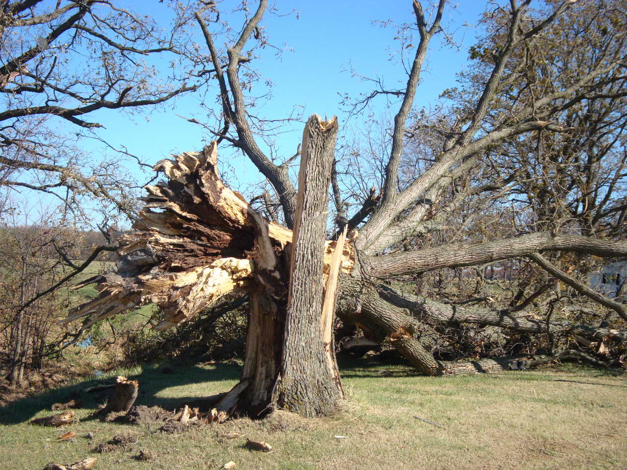
Significant damage reports including generalized narrative and known injuries/fatalities...Thirteen tornadoes were produced from 4 separate LEWP segments and 1 low topped supercell. Most damage was on the scale of an EF0 tornado with the most intense damage rated as EF1. Each misocylone produced widespread 60-80 mph wind around any tornado damage, likely a result of the pressure perturbation associated with the circulation. |
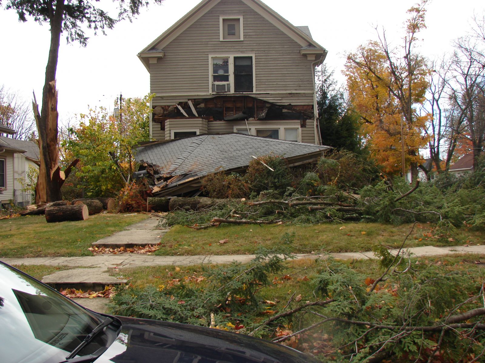
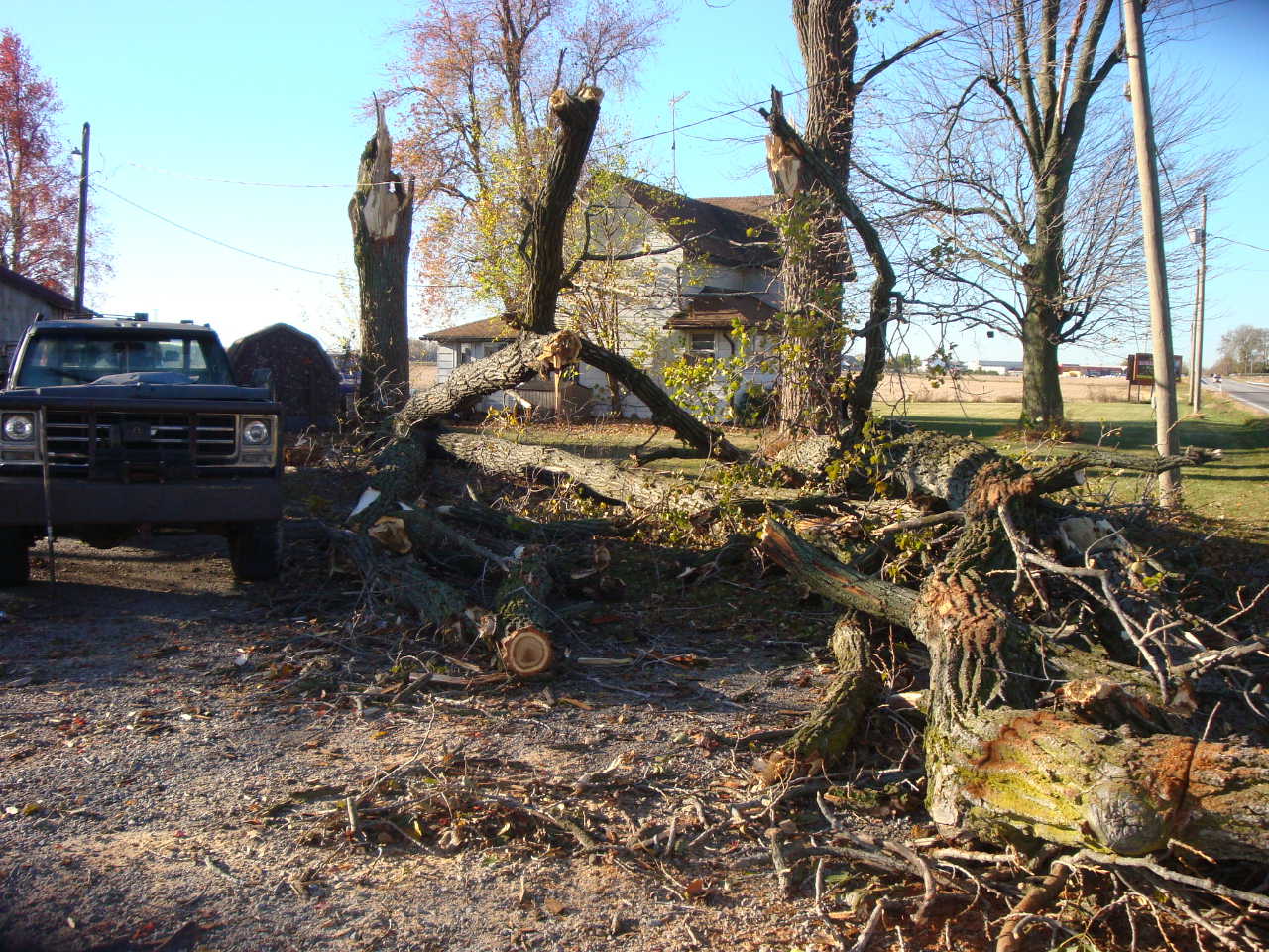
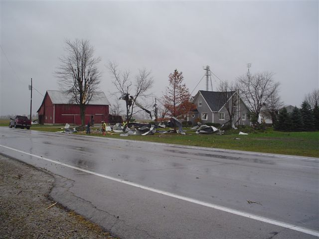
...PRELIMINARY EF1 TORNADO IN LAPORTE COUNTY

A NATIONAL WEATHER SERVICE STORM SURVEY TEAM HAS EXAMINED DAMAGE IN
WANATAH IN LAPORTE COUNTY INDIANA. A COMBINATION OF DAMAGE AND EYE
WITNESS REPORTS CONFIRMS THAT A TORNADO DID BRIEFLY TOUCHDOWN NEAR
THE INTERSECTION OF US 30 AND US 421 AT AROUND 842 AM CDT AND
RAPIDLY MOVED NORTHEAST.

THE TORNADO DESTROYED A 50 FOOT BY 200 FT OPEN SHELTER...RIPPED
THE ROOF OFF OF AN ATTACHED GARAGE OF A HOUSE AND SNAPPED A FEW
POWER POLES. THE DAMAGE IS CONSISTENT WITH A LOW-END EF1 WITH
MAXIMUM WINDS ESTIMATED IN THE 85 TO 90 MPH RANGE. THE TORNADO WAS
ON THE GROUND APPROXIMATELY ONE MILE WITH A MAXIMUM WIDTH OF 100
YARDS. THE EXACT TRACK LENGTH AND WIDTH MAY CHANGE AFTER FURTHER
EXAMINATION OF DATA.
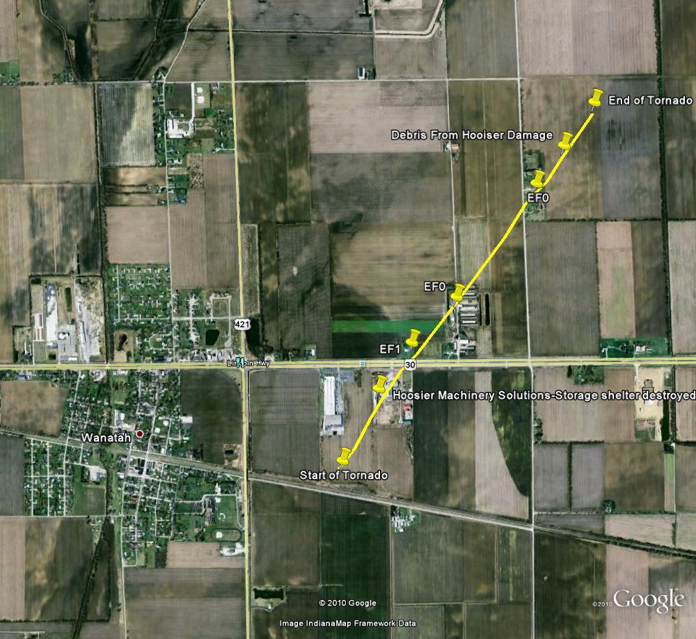
Here are a few pictures of the damage associated with this tornado. (Courtesy Laporte Co EMA)
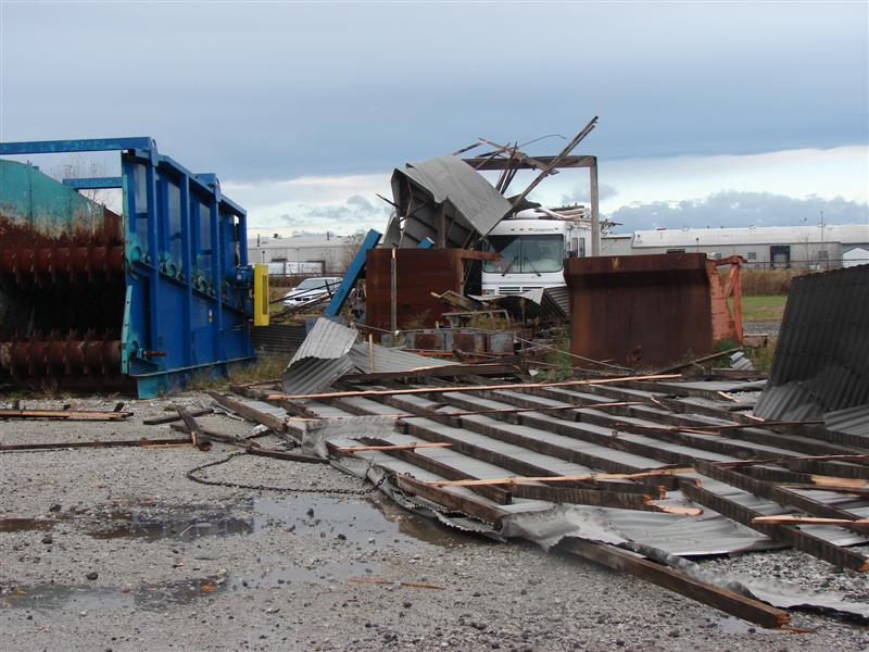

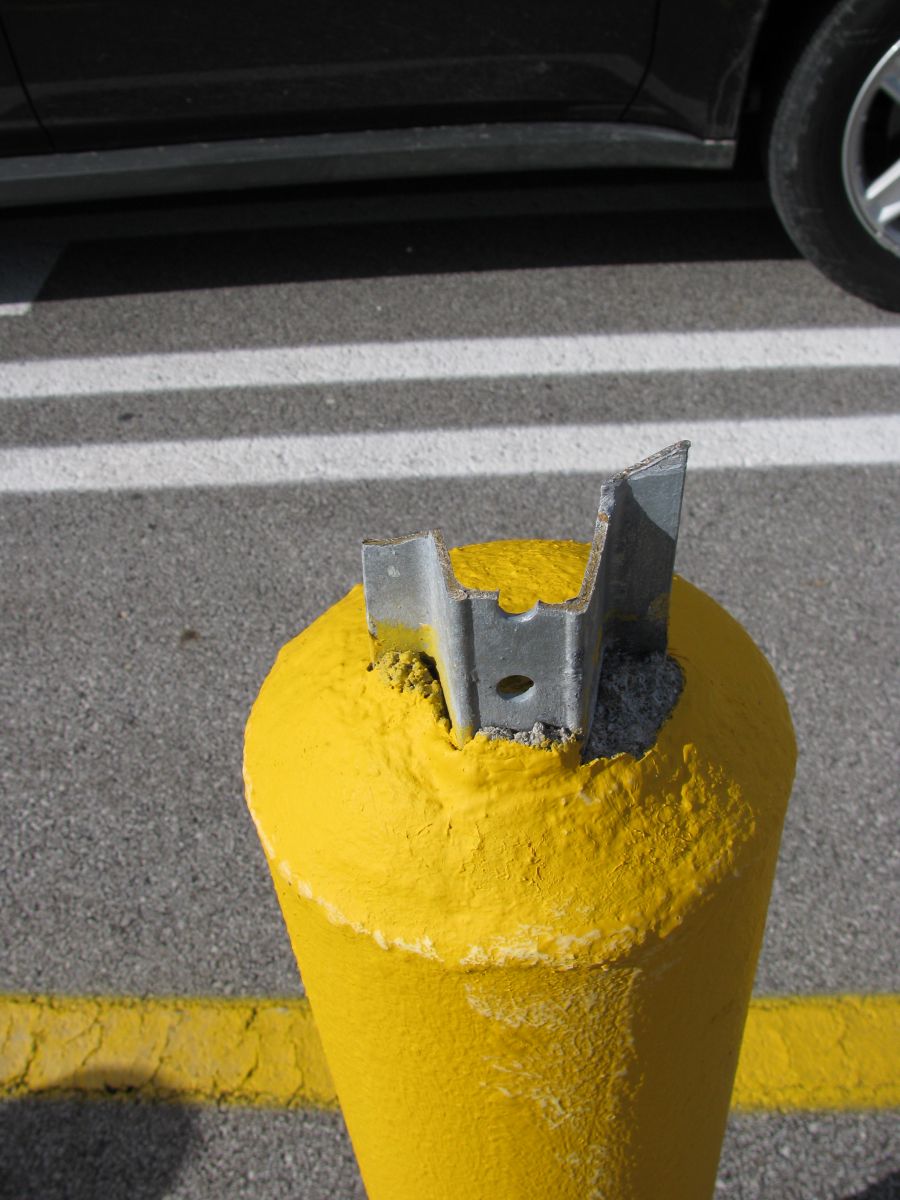
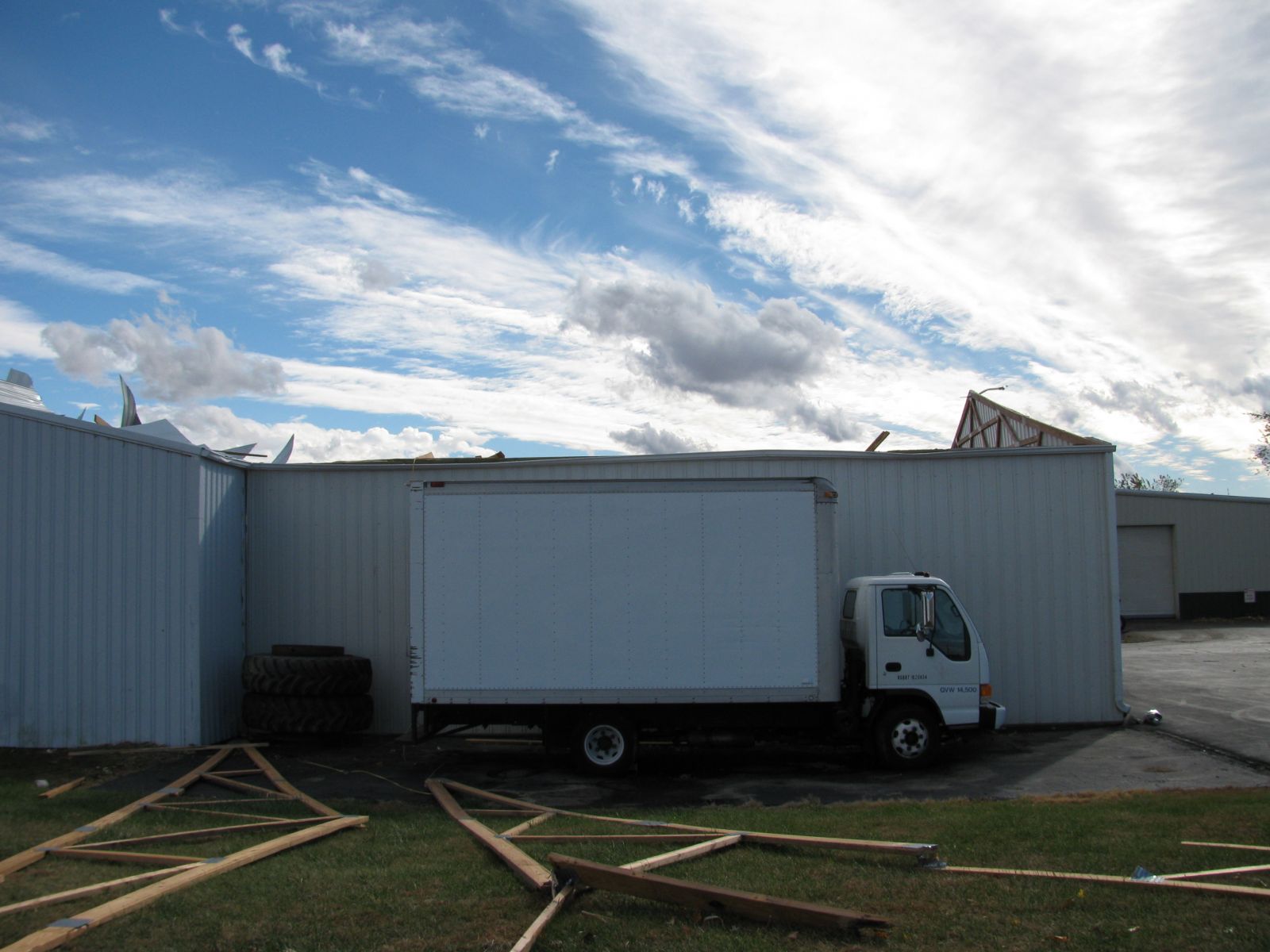
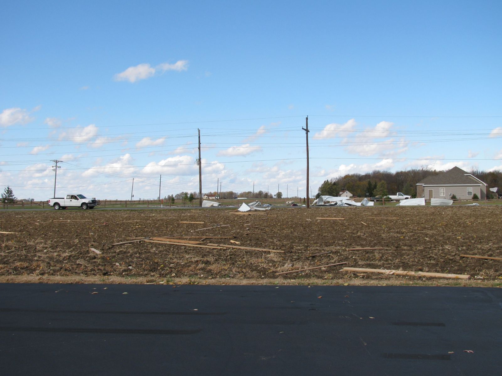
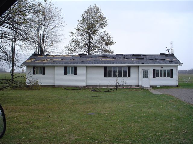
...PRELIMINARY EF0 TORNADO IN WABASH COUNTY...

A NATIONAL WEATHER SERVICE STORM SURVEY TEAM HAS EXAMINED DAMAGE IN
WABASH COUNTY INDIANA AND FOUND EVIDENCE OF A HIGH END EF0
TORNADO. THE TORNADO BEGAN AT THE INTERSECTION OF HIGHWAYS 24 AND
15 IN WABASH AROUND 1020 AM EDT. DAMAGE OCCURRED AT THE WALMART
SHOPPING COMPLEX WITH DAMAGE TO AIR CONDITIONER UNITS...WINDOWS
BLOWN OUT AND SOME EXTERIOR BUILDING DAMAGE. A ROOF WAS ALSO TORN
OFF A VOCATIONAL CENTER NEAR THIS LOCATION. THIS DAMAGE WAS RATED
AS HIGH END EF0 WITH ESTIMATED SPEEDS OF 80 TO 85 MPH.

THIS TORNADO CONTINUED NORTHEAST FOR ABOUT 4.8 MILES AND ENDED
NEAR THE INTERSECTION OF 300N AND 100E NEAR SPIKERVILLE WITH
DAMAGE INDICATIVE OF EF0 STRENGTH TORNADO.
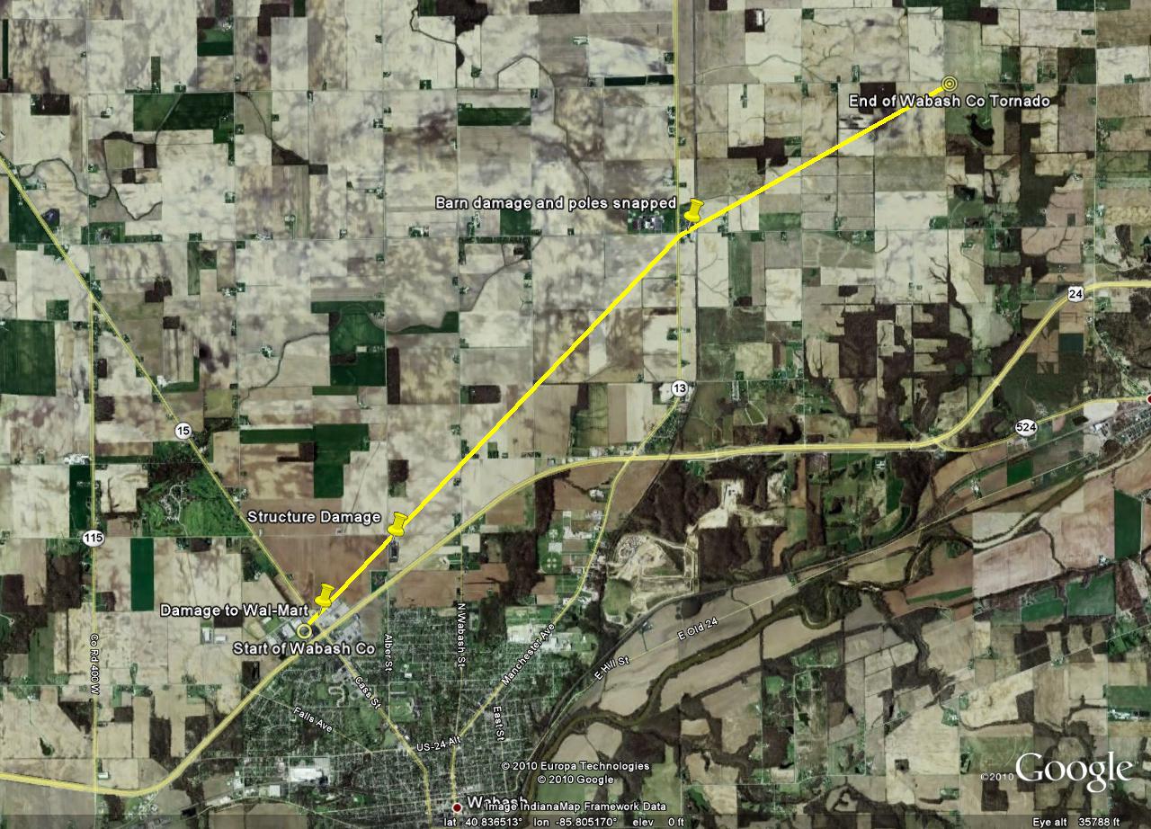
Here are a few pictures of the damage associated with this tornado.

A piece of debris was embedded into the side of Wal-Mart
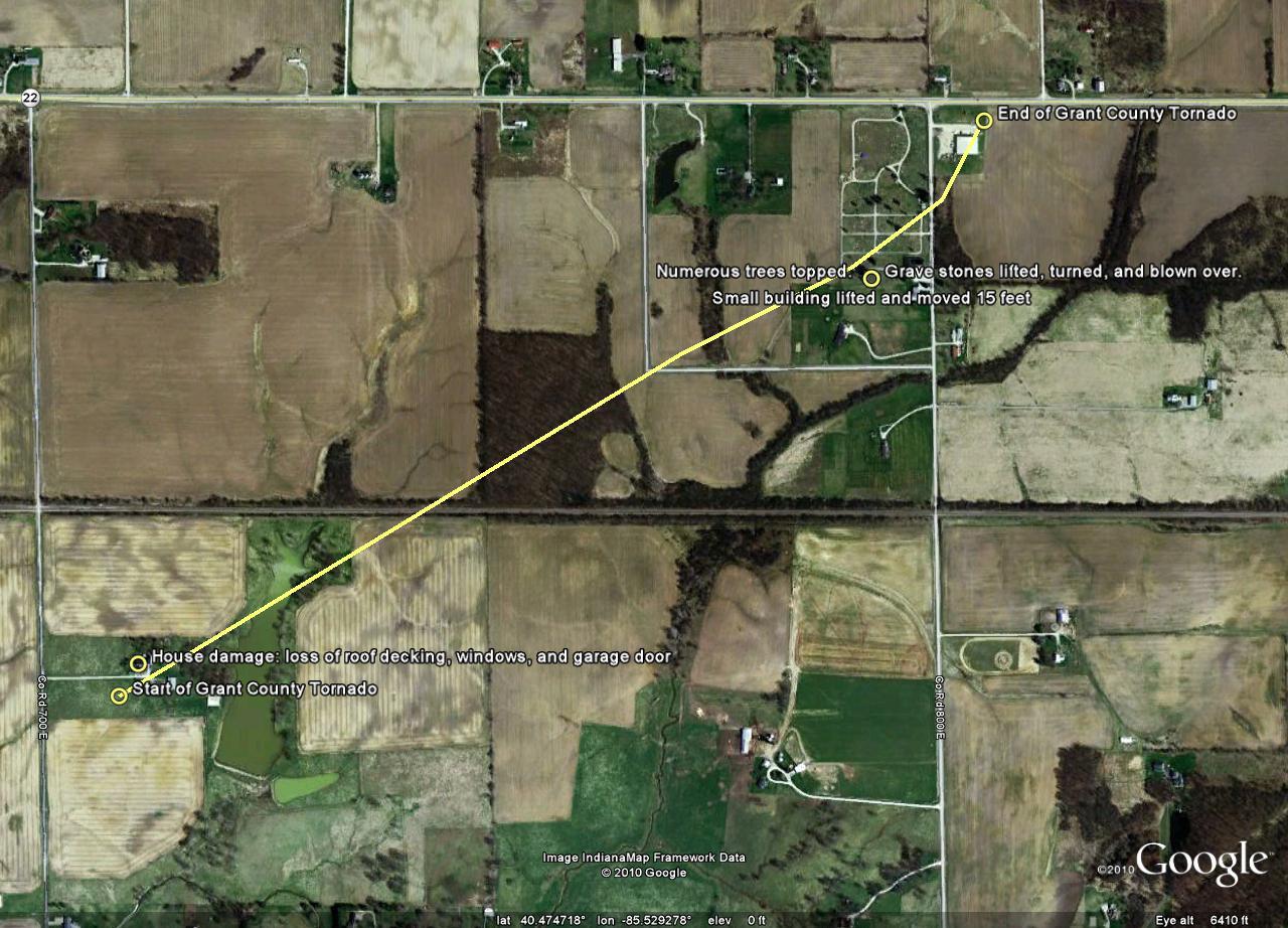
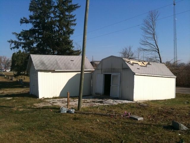
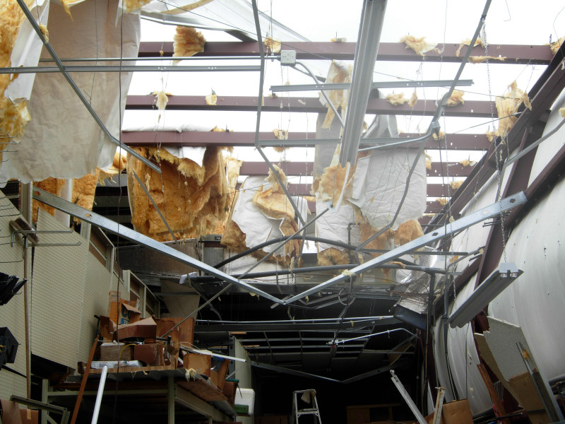
...PRELIMINARY EF1 TORNADO IN GRANT COUNTY INDIANA...

A NATIONAL WEATHER SERVICE STORM SURVEY TEAM HAS EXAMINED DAMAGE IN
SOUTHEAST GRANT COUNTY INDIANA AND FOUND EVIDENCE OF AN EF1 TORNADO.

THE TORNADO BEGAN APPROXIMATELY ONE QUARTER MILE NORTH OF THE
INTERSECTION OF 600 S AND 700 E AND MOVED NORTHEAST...ENDING NEAR
THE INTERSECTION OF 500 S AND 800 E. DAMAGE PATH LENGTH WAS ABOUT
ONE MILE AND MAXIMUM DAMAGE WIDTH WAS AROUND 100 YARDS WIDE. A HOUSE
WAS INITIALLY HIT SUSTAINING LOSS OF ROOF DECKING...BROKEN WINDOWS...
AND GARAGE DOOR DAMAGE. THE TORNADO THEN IMPACTED A CEMETERY LIFTING...
TURNING...AND BLOWING OVER GRAVESTONES. A SMALL BUILDING AT THE CEMETERY
WAS ALSO LIFTED AND MOVED 15 FEET. THE TORNADO THEN HIT A HARDWARE
STORE...BLOWING THE SOUTH SIDE WALL IN WITH THE NORTH SIDE DOORS ALSO
BEING BLOWN IN. SOME ROOF DAMAGE ALSO OCCURRED.

WIND SPEEDS ASSOCIATED WITH AN EF1 TORNADO RANGE FROM 86 TO 110 MPH.
MAXIMUM ESTIMATED WINDS ASSOCIATED WITH THIS TORNADO WERE AROUND 97
TO 100 MPH.
Here are a few pictures of the damage associated with this tornado.


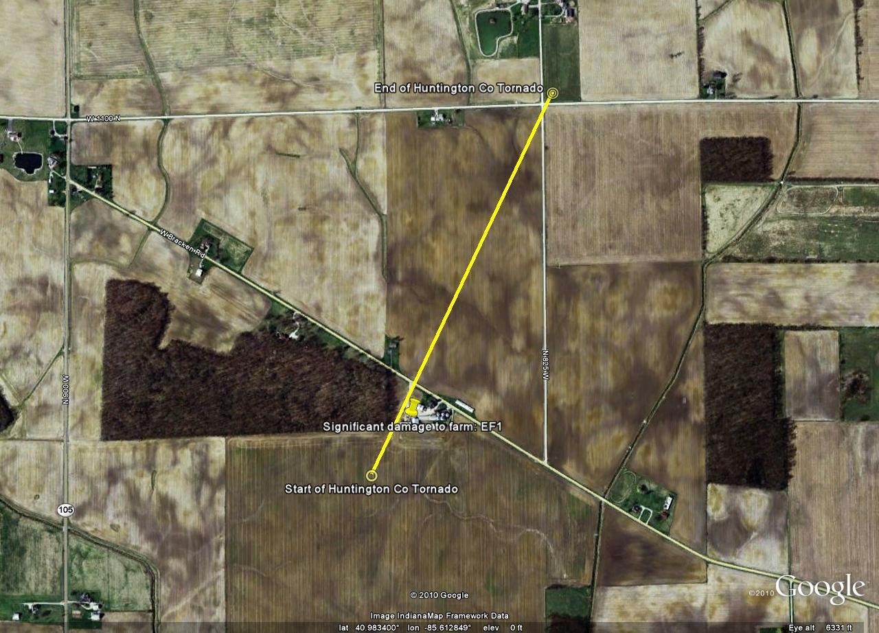
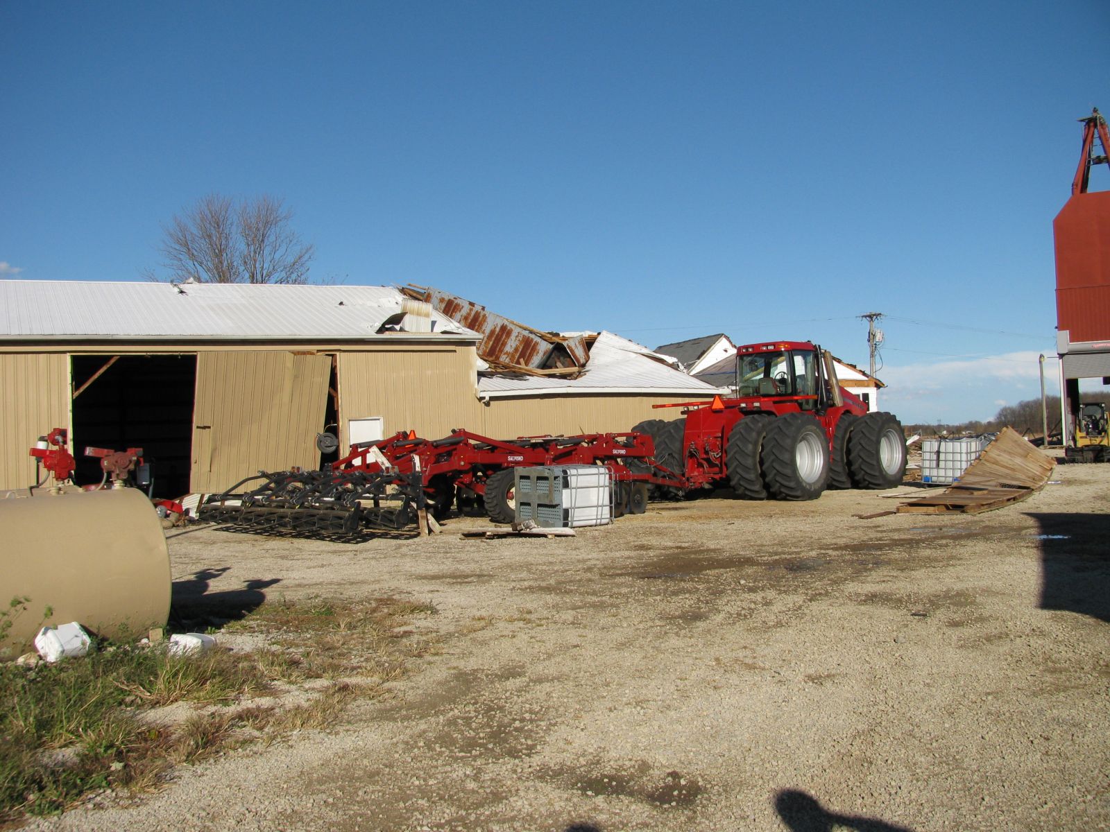
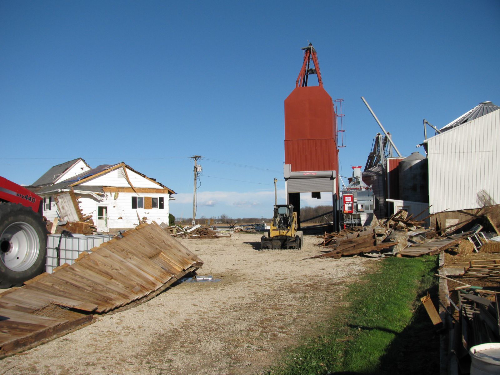
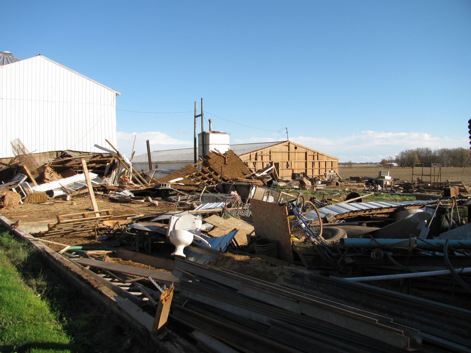
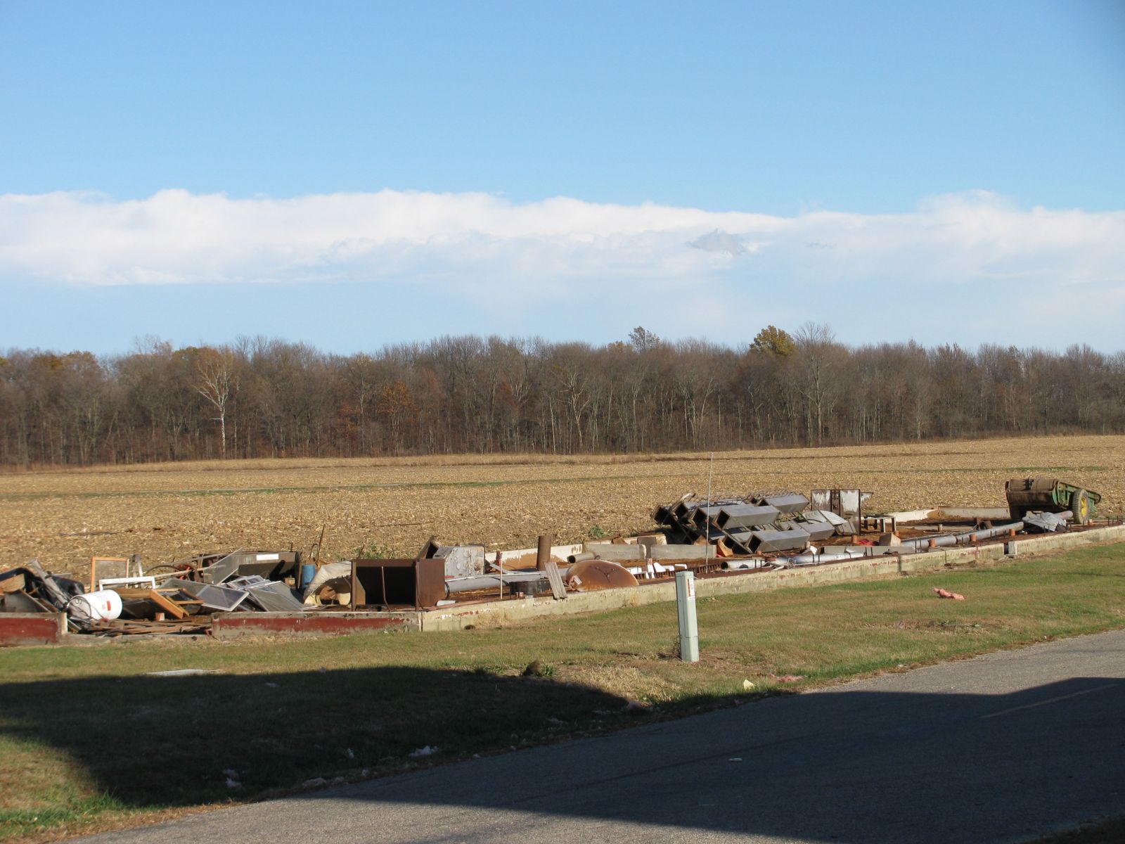
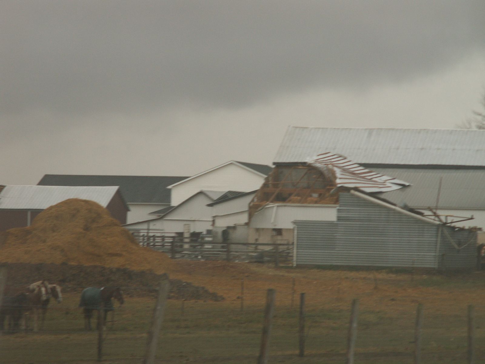
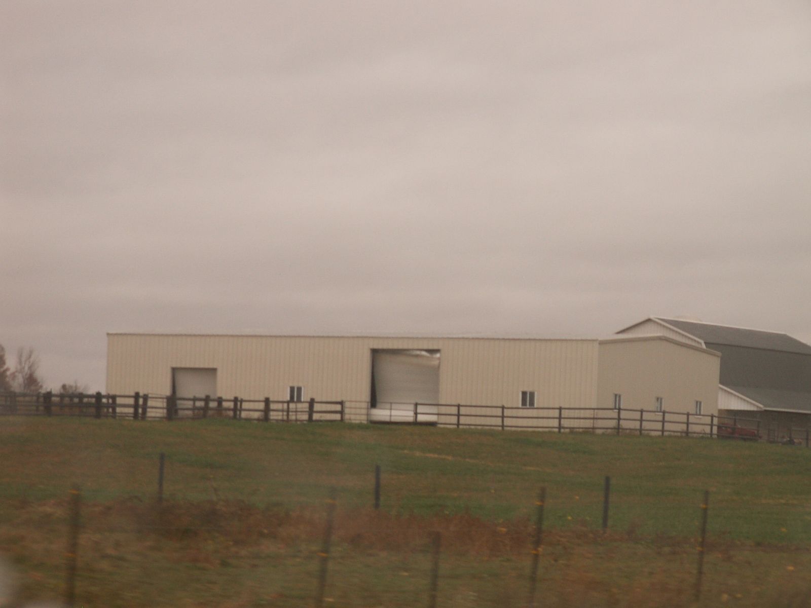
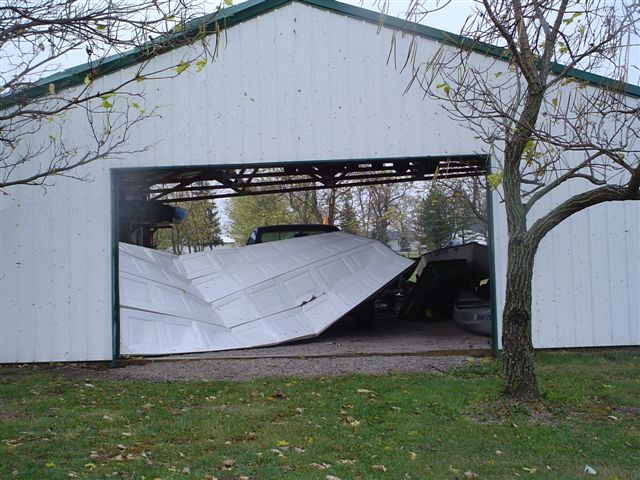
...PRELIMINARY EF1 TORNADO IN HUNTINGTON COUNTY...

A NATIONAL WEATHER SERVICE STORM SURVEY TEAM HAS EXAMINED DAMAGE IN
NORTHWEST HUNTINGTON COUNTY INDIANA AND FOUND EVIDENCE OF AN EF1
TORNADO.

THE TORNADO BEGAN AT THE INTERSECTION OF 825W AND BRACKEN ROAD AND
ENDED TO THE NORTHEAST NEAR THE INTERSECTION OF 1100N AND 825W.
DAMAGE PATH LENGTH WAS ABOUT SIX TENTHS OF A MILE AND DAMAGE WIDTH
WAS 50 TO 75 YARDS WIDE. SEVERAL OUTBUILDINGS WERE HEAVILY DAMAGED
AND A METAL GRAIN BIN WAS DESTROYED WITH THE DEBRIS TWISTED AND
BLOWN NORTHWEST. WOOD PROJECTILES WERE LODGED INTO THE ROOF OF A
HOUSE AND CONCRETE BLOCKS WERE LOFTED ONTO THE ROOF OF SMALL
BUILDING. THE DEBRIS FIELD WAS STREWN TO THE NORTHEAST OVER A
DISTANCE OF ABOUT ONE MILE.

WIND SPEEDS ASSOCIATED WITH AN EF1 TORNADO RANGE FROM 86 TO 110 MPH.
Here are a few pictures of the damage associated with this tornado.


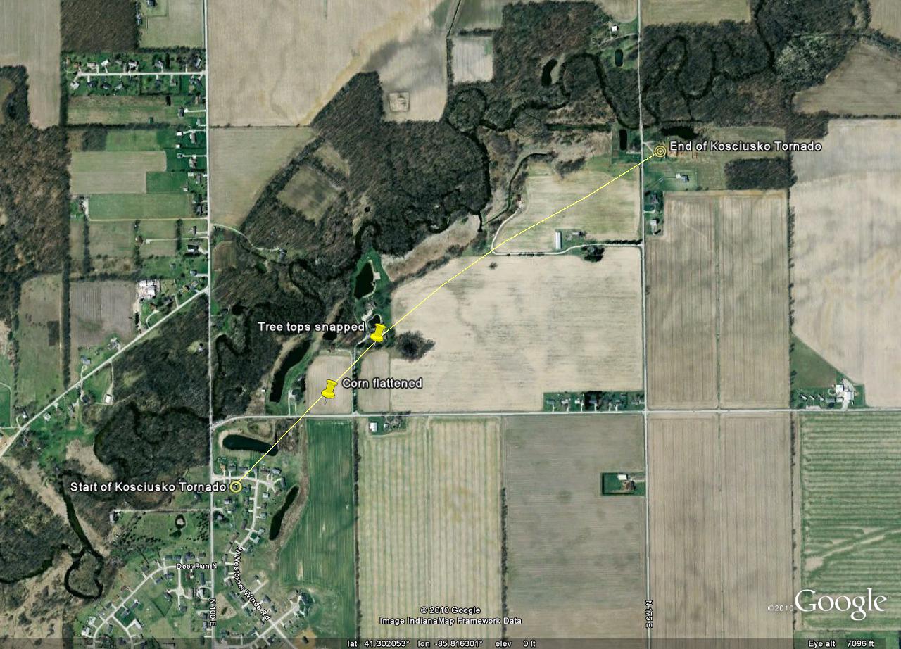
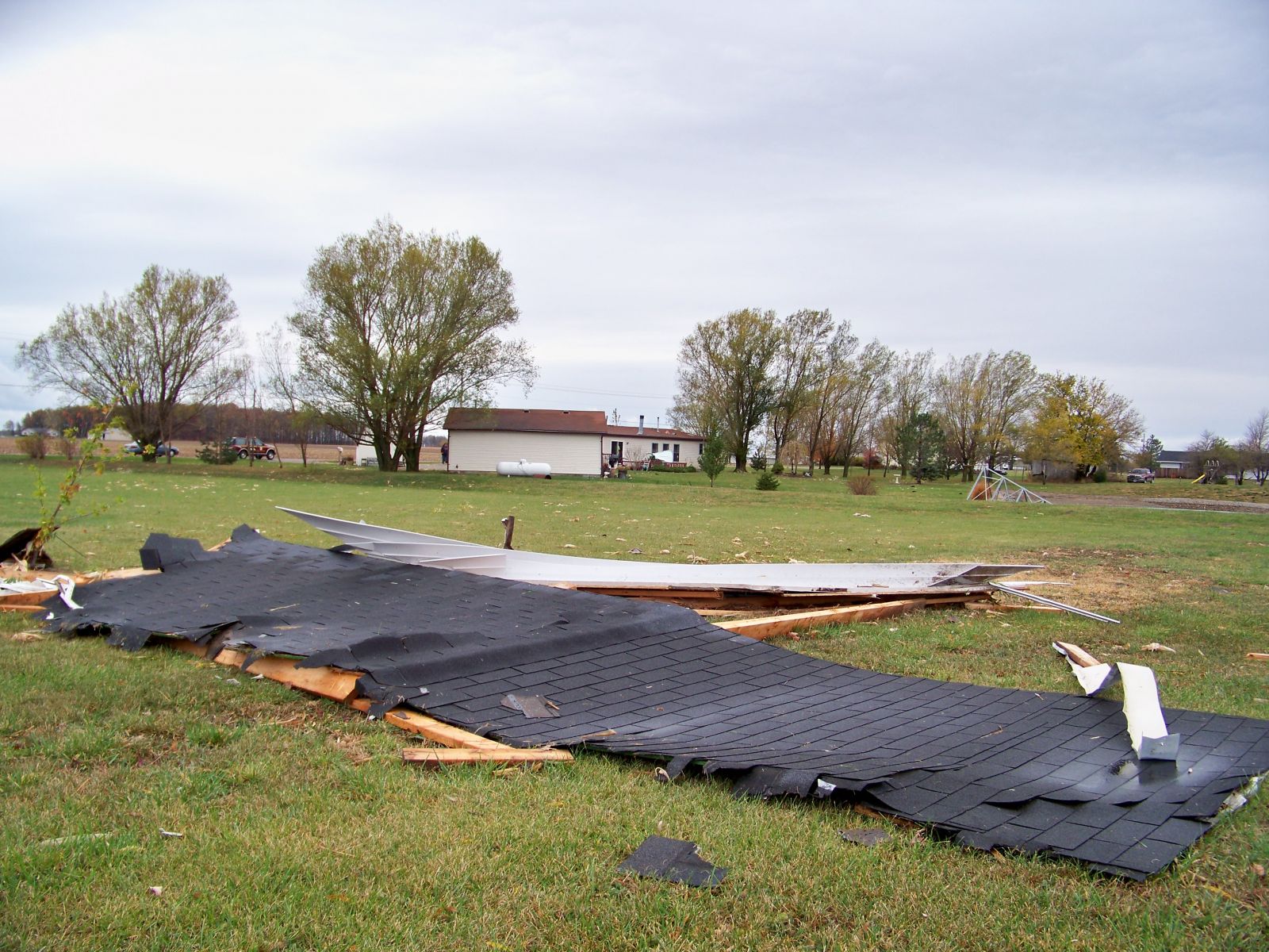
...PRELIMINARY EF0 TORNADO IN KOSCIUSKO COUNTY INDIANA...

A NATIONAL WEATHER SERVICE STORM SURVEY TEAM HAS EXAMINED DAMAGE IN CENTRAL
KOSCIUSKO COUNTY INDIANA AND FOUND EVIDENCE OF AN EF0 TORNADO.

THE TORNADO BEGAN JUST SOUTHEAST OF THE INTERSECTION OF 450N AND 100E
AND MOVED NORTHEAST...ENDING NEAR 175E JUST SOUTH OF THE TIPPECANOE RIVER.
DAMAGE PATH LENGTH WAS ABOUT ONE MILE AND DAMAGE WIDTH WAS AROUND 30 YARDS
WIDE. NEAR THE BEGINNING OF THE PATH...SHINGLE DAMAGE WAS FOUND IN A SUBDIVISION.
YARD ITEMS...INCLUDING A SWING...WERE THROWN INTO A POND. AS THE TORNADO MOVED
NORTHEAST AND CROSSED 450N...CORN WAS FOUND FLATTENED. SHEARED TREES WERE
FOUND ALONG THE DAMAGE PATH...AS WELL AS A SNAPPED POWER POLE. NEAR THE END
OF THE DAMAGE PATH...A RADIO TOWER WAS BENT OVER BY THE WINDS.

WIND SPEEDS ASSOCIATED WITH AN EF0 TORNADO RANGE FROM 65 TO 85 MPH. MAXIMUM
ESTIMATED WINDS ASSOCIATED WITH THIS TORNADO WERE AROUND 80 MPH.
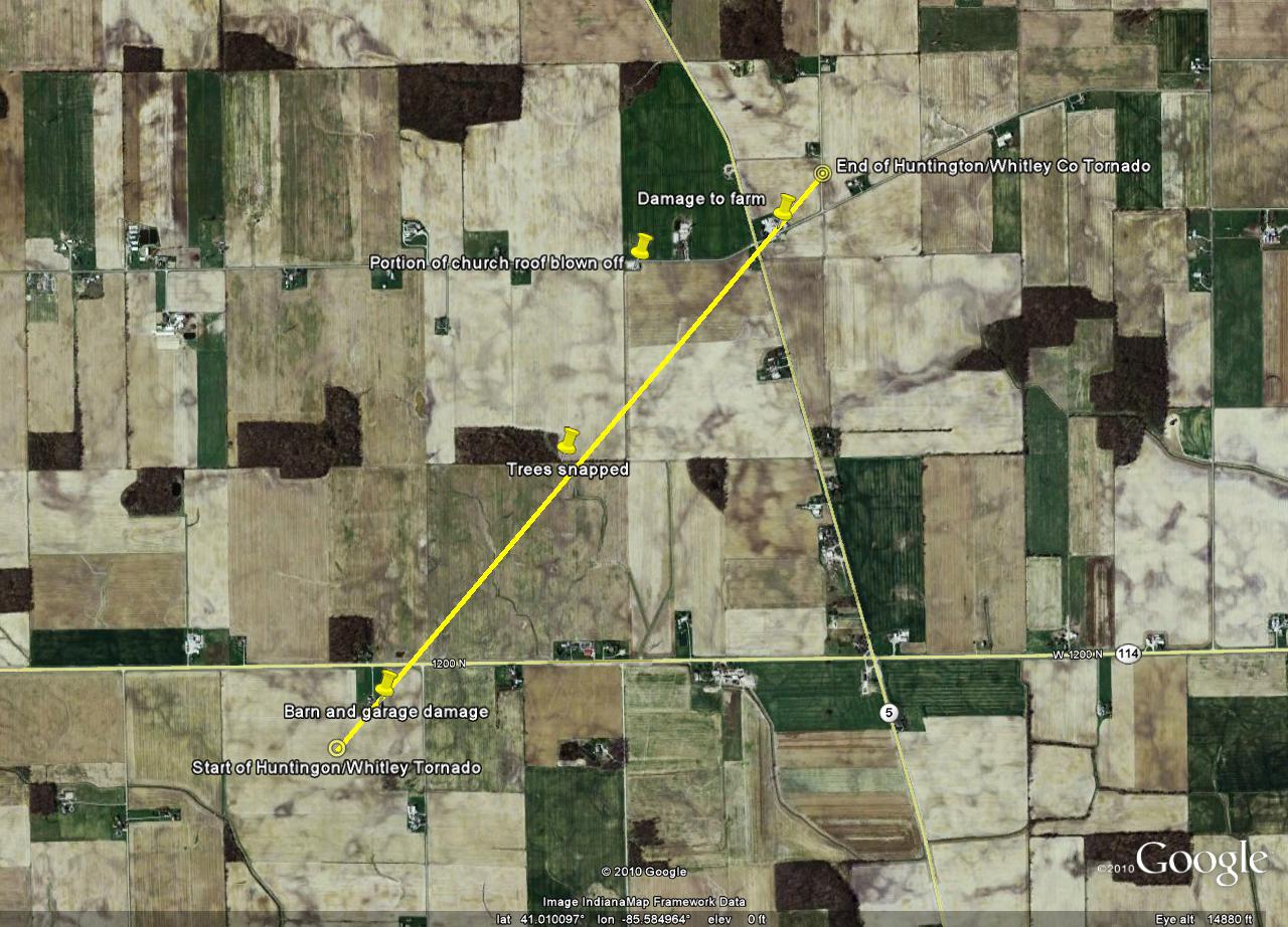
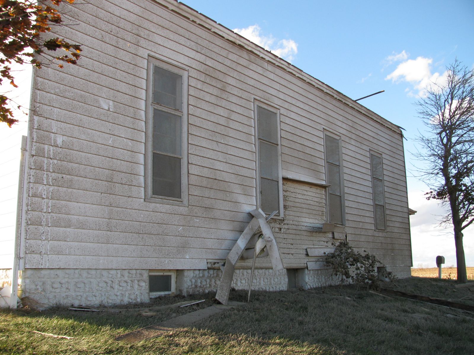
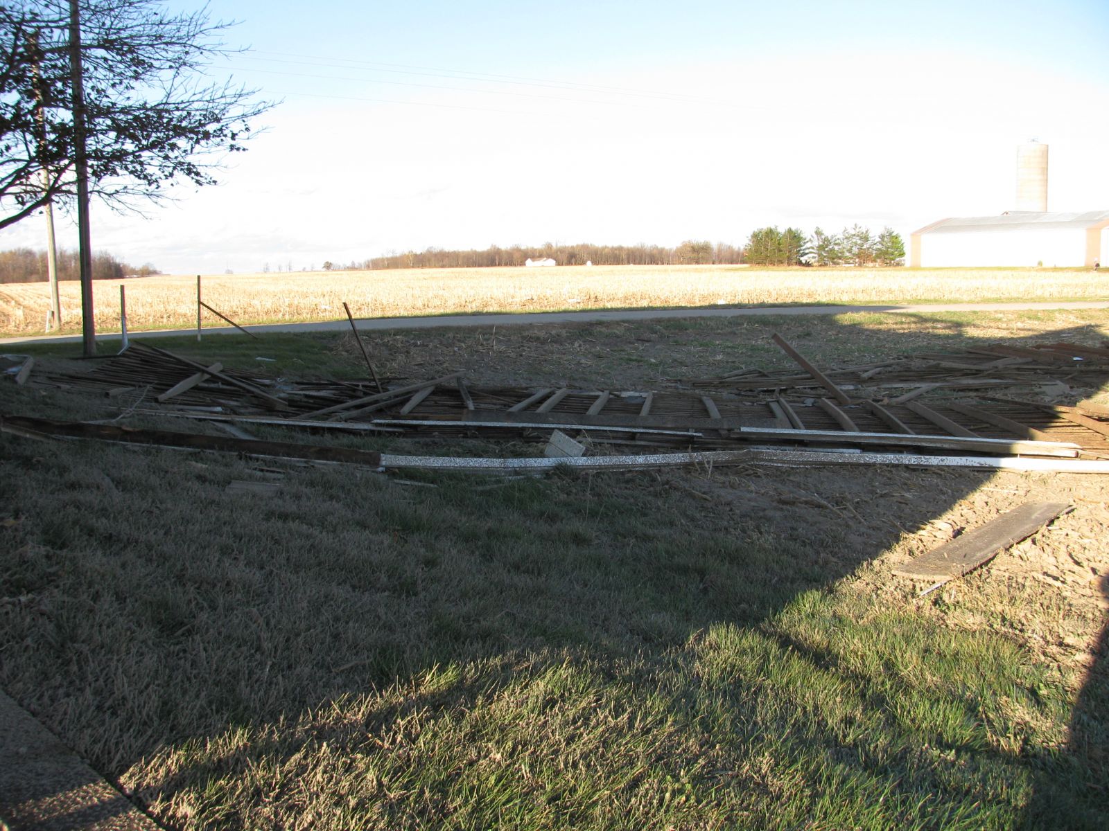
...PRELIMINARY EF0 TORNADO IN HUNTINGTON AND WHITLEY COUNTIES...

A NATIONAL WEATHER SERVICE STORM SURVEY TEAM HAS EXAMINED DAMAGE IN
EXTREME NORTHWEST HUNTINGTON COUNTY AND SOUTHWEST WHITLEY COUNTY
INDIANA...AND FOUND EVIDENCE OF AN EF0 TORNADO.

THE TORNADO BEGAN AT THE INTERSECTION OF 750W AND STATE ROAD 114 AND
AND ENDED TO THE NORTHEAST NEAR THE INTERSECTION OF HENRY RD AND
450W IN WHITLEY COUNTY. DAMAGE PATH LENGTH WAS ABOUT 2 MILES LONG.
DAMAGE WIDTH WAS 75 YARDS WIDE. FARM OUTBUILDINGS WERE DAMAGED AND
SMALL METAL GRAIN BINS WERE DESTROYED WITH THE DEBRIS TWISTED AND
BLOWN SEVERAL YARDS TO THE NORTHEAST. ONE HOUSE SUSTAINED MINOR
DAMAGE WITH BROKEN WINDOWS. MINOR TREE DAMAGE WAS ALSO OBSERVED.

WIND SPEEDS ASSOCIATED WITH AN EF0 TORNADO RANGE FROM 65 TO 85
MPH.
Here are a few pictures of the damage to a church associated with this tornado.
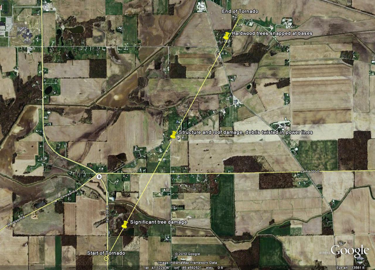
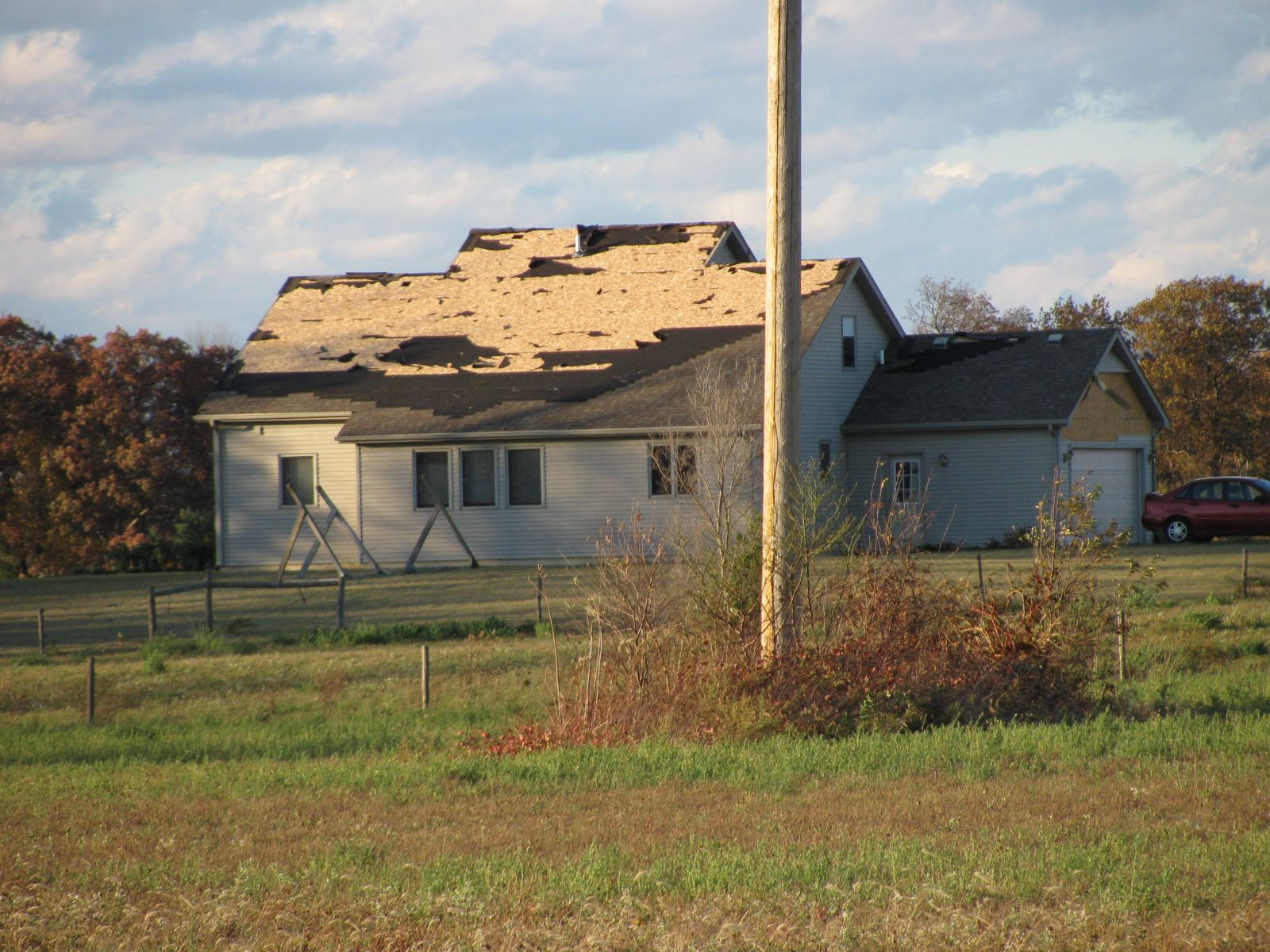
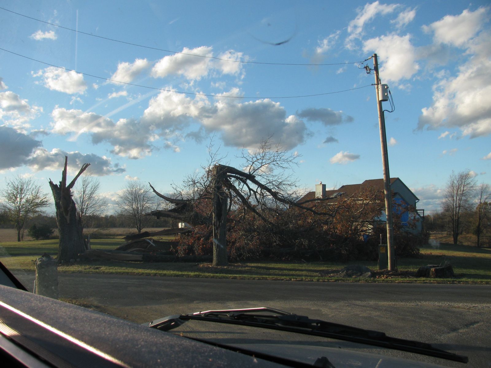
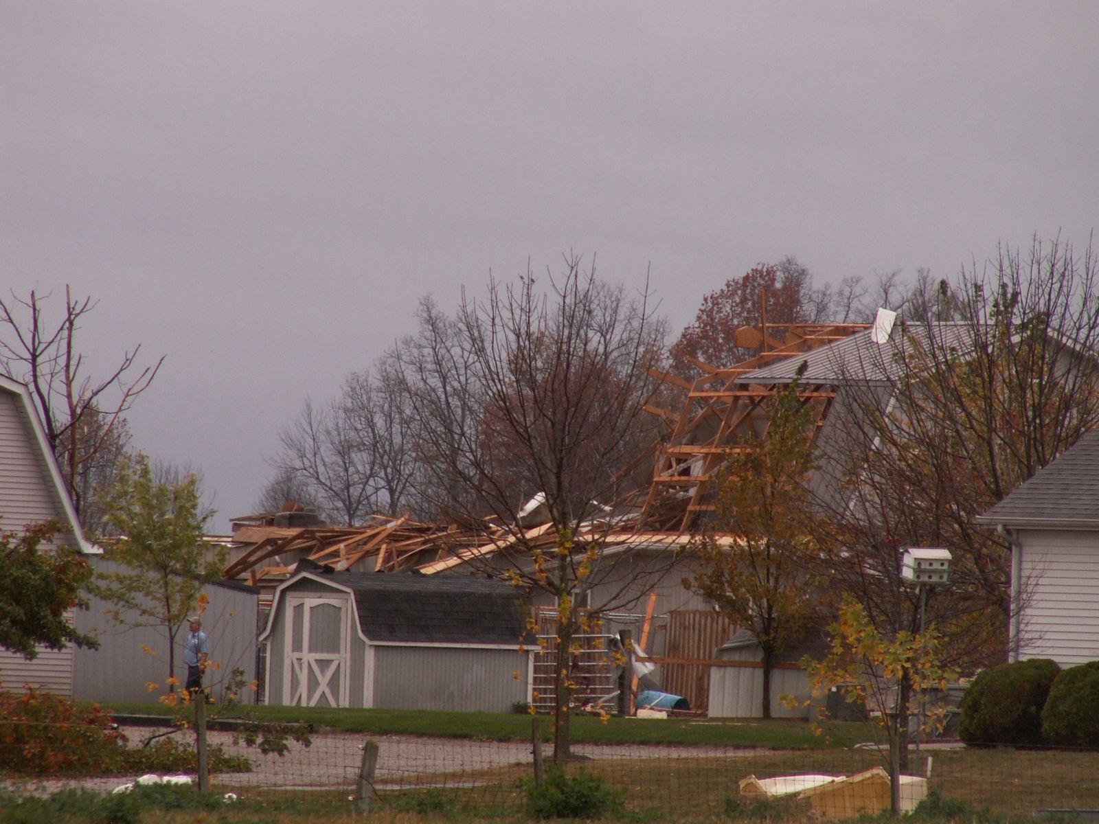
...PRELIMINARY EF1 TORNADO IN WHITLEY COUNTY...

A NATIONAL WEATHER SERVICE STORM SURVEY TEAM HAS EXAMINED DAMAGE IN
WHITLEY COUNTY INDIANA AND FOUND EVIDENCE OF AN EF1
TORNADO.

THE TORNADO BEGAN ONE HALF MILE NORTH OF THE INTERSECTION OF 400S
AND STATE ROAD 9 AND ENDED TO THE NORTHEAST...ONE HALF MILE TO THE
EAST OF THE INTERSECTION OF MOWERY RD AND RAEBER RD. DAMAGE PATH
LENGTH WAS ABOUT 2 MILES AND DAMAGE WIDTH WAS 50 TO 150 YARDS WIDE.
SEVERAL TREES WERE SNAPPED AND UPROOTED ALONG THE PATH. NUMEROUS
HOUSES RECEIVED MINOR TO MODERATE ROOF DAMAGE WITH SOME WINDOWS
DAMAGED. THERE WERE ALSO A FEW HEAVILY DAMAGED OUTBUILDINGS WITH
DEBRIS CARRIED UP TO 1 MILE TO THE NORTHEAST.

WIND SPEEDS ASSOCIATED WITH AN EF1 TORNADO RANGE FROM 86 TO 110
MPH.
Here are a few pictures of the damage associated with this tornado.


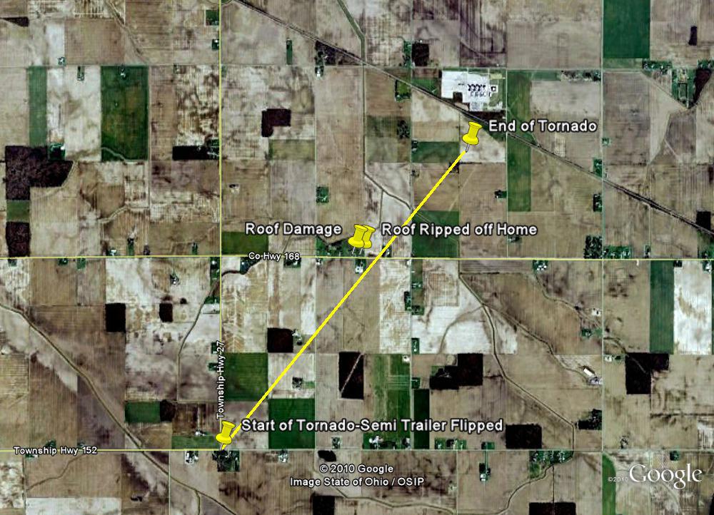
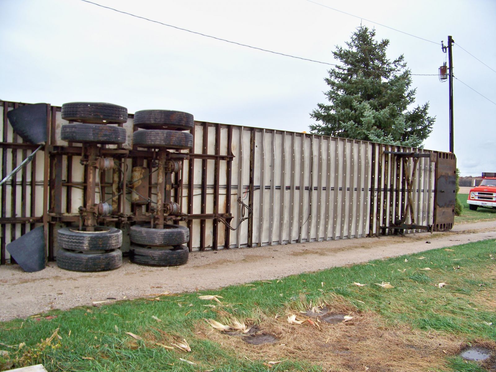
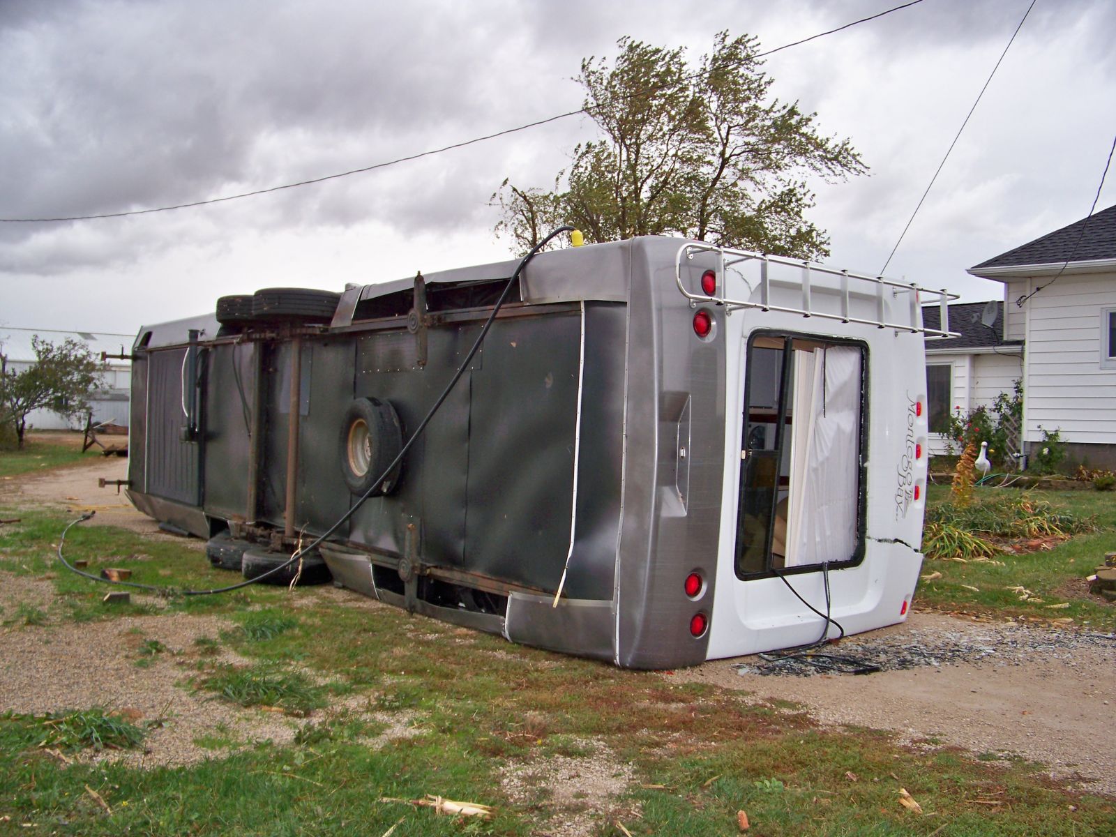
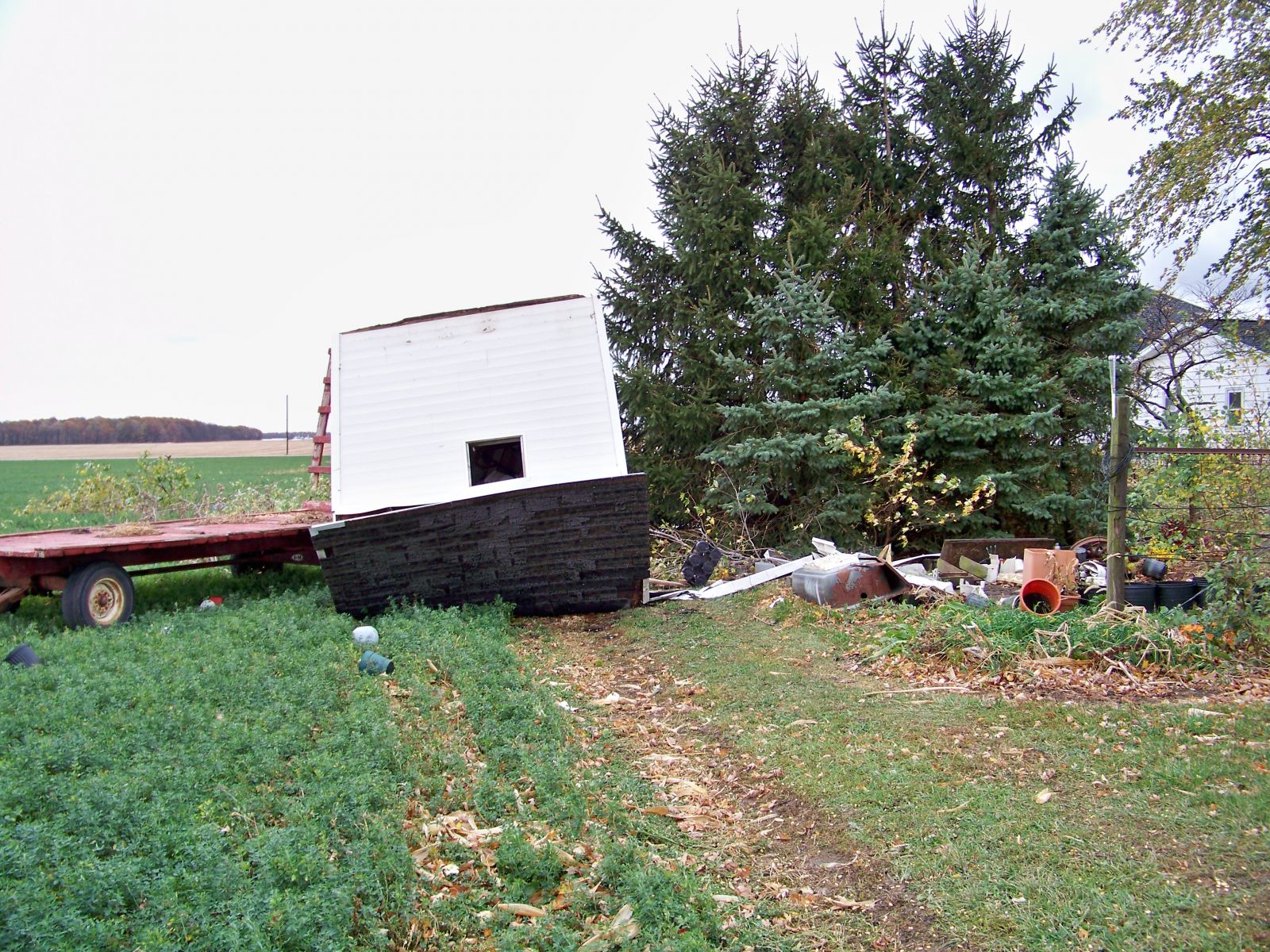
...PRELIMINARY EF0 TORNADO IN VAN WERT COUNTY OH...

THE NATIONAL WEATHER SERVICE IN NORTHERN INDIANA AND VAN WERT COUNTY
EMERGENCY MANAGEMENT HAVE DETERMINED AN EF0 TORNADO OCCURRED IN VAN WERT
COUNTY OHIO. THE TORNADO BEGAN 3.5 MILES SOUTHWEST OF CONVOY AT THE
INTERSECTION OF TULLEY HARRISON ROAD AND MENTZER CHURCH ROAD. AT
THIS LOCATION A LARGE SEMI TRAILER AND CAMPER WERE FLIPPED AND A
BARN ROOF WAS TORN OFF. THE TORNADO THEN CONTINUED NORTHEAST TO
CONVOY ROAD BETWEEN VAN HORN AND LARE ROADS. THE ROOF TO A HOUSE
WAS COMPLETELY TORN OFF AND THROWN 100 YARDS TO THE NORTHEAST AND A
LARGE WINDMILL WAS CARRIED 40 YARDS. A SHED ACROSS THE STREET WAS DESTROYED.
THE ROOF ON A HOUSE NEXT DOOR WAS SEVERELY DAMAGED. THIS DEBRIS WAS
CARRIED 2.5 MILES TO THE NORTHEAST. THE TORNADO THEN CROSSED LARE ROAD
WHERE IT DESTROYED A BARN BEFORE LIFTING. THIS BARN WAS FOUND 0.75 MILES
AWAY. PRELIMINARY TOTAL PATH LENGTH IS 3.5 MILES WITH A MAXIMUM WIDTH OF
80 YARDS. MAXIMUM WIND SPEEDS ARE ESTIMATED AT 80 MPH.
Here are some pictures of the damage sustained. All photos courtesy Rick McCoy, Van Wert County EM.


>
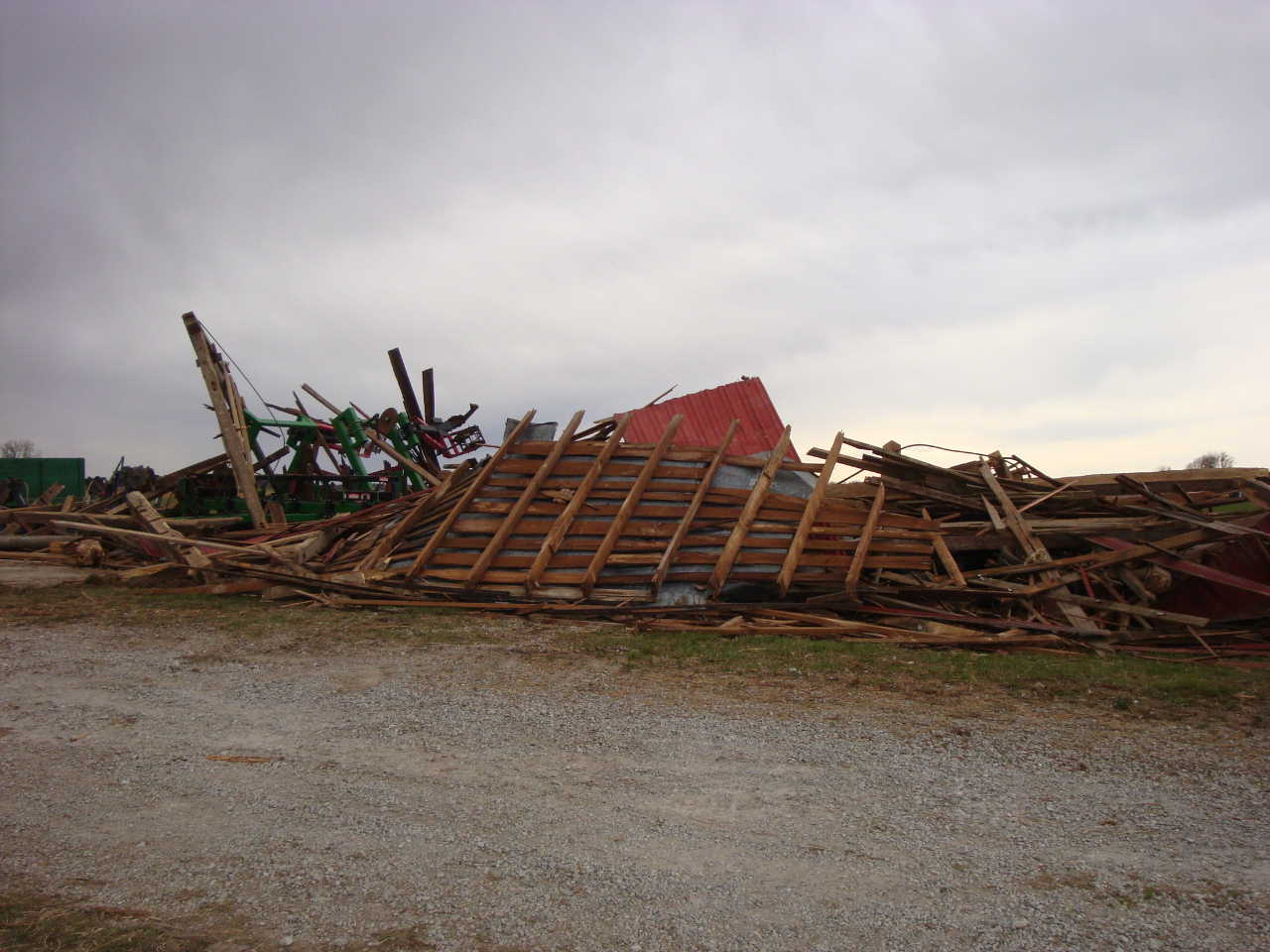
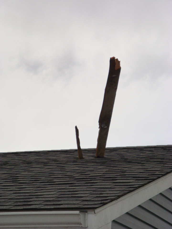
...PRELIMINARY EF1 TORNADO IN ALLEN COUNTY INDIANA...

A NATIONAL WEATHER SERVICE STORM SURVEY TEAM HAS EXAMINED DAMAGE IN
EASTERN ALLEN COUNTY INDIANA AND FOUND EVIDENCE OF AN EF1 TORNADO.

THE TORNADO BEGAN ON ROUSSEY ROAD BETWEEN RORICK ROAD AND HOWE
ROAD AND MOVED NORTHEAST...ENDING ON EDGERTON ROAD BETWEEN ROUSSEY
ROAD AND SAMPSON ROAD. DAMAGE PATH LENGTH WAS ABOUT ONE AND A HALF MILES
AND MAXIMUM DAMAGE WIDTH WAS AROUND 175 YARDS WIDE. A BARN DOOR WAS
RIPPED OFF A BARN AS THE TORNADO TOUCHED DOWN...AND A LARGE TREE WAS
BLOWN OVER. AS THE TORNADO MOVED NORTHEAST...A BARN WAS DESTROYED.
WINDOWS WERE BLOWN OUT OF A HOUSE NEAR THE BARN AND DEBRIS FROM THE
BARN WAS FOUND LODGED INTO THE ROOF OF THE HOUSE. FURTHER NORTHEAST...
FOUR OPEN AIR TRAIN CARS WERE BLOWN OFF OF THE TRAIN TRACKS ONTO THEIR
SIDES. DEBRIS FROM THE DESTROYED BARN WAS CARRIED NORTHEAST AND FOUND
WHERE THE TORNADO LIFTED.

WIND SPEEDS ASSOCIATED WITH AN EF1 TORNADO RANGE FROM 86 TO 110 MPH.

MAXIMUM ESTIMATED WINDS ASSOCIATED WITH THIS TORNADO WERE AROUND 105 MPH.
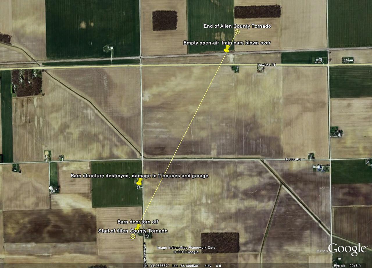
Here are a few pictures of the damage associated with this tornado.

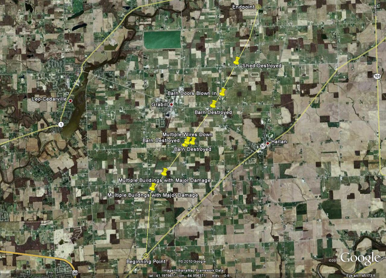
...PRELIMINARY EF1 TORNADO IN ALLEN COUNTY INDIANA...

A NATIONAL WEATHER SERVICE STORM SURVEY TEAM HAS EXAMINED DAMAGE IN
NORTHEAST ALLEN COUNTY INDIANA AND FOUND EVIDENCE OF AN EF1 TORNADO.

THE TORNADO BEGAN NEAR THE INTERSECTION OF GRABER ROAD AND MAYSVILLE
ROAD. THE TORNADO WAS ON THE GROUND FOR NEARLY 7 MILES BEFORE LIFTING
AT THE INTERSECTION OF MARKLE AND BOGER ROADS. AT THE WIDEST POINT...
TORNADO DAMAGE WAS ABOUT A HALF MILE WIDE SOUTHEAST OF GRABILL. MODERATE
DAMAGE WAS OBSERVED TO MANY STRUCTURES...INCLUDING NUMEROUS BARNS
DESTROYED...DOWNED POWER POLES AND TREE DAMAGE.

WIND SPEEDS ASSOCIATED WITH AN EF1 TORNADO RANGE FROM 86 TO 110 MPH
AND THE SURVEY TEAM ESTIMATES THE MAXIMUM WINDS WITH THIS EVENT TO
BE 95 MILES PER HOUR.
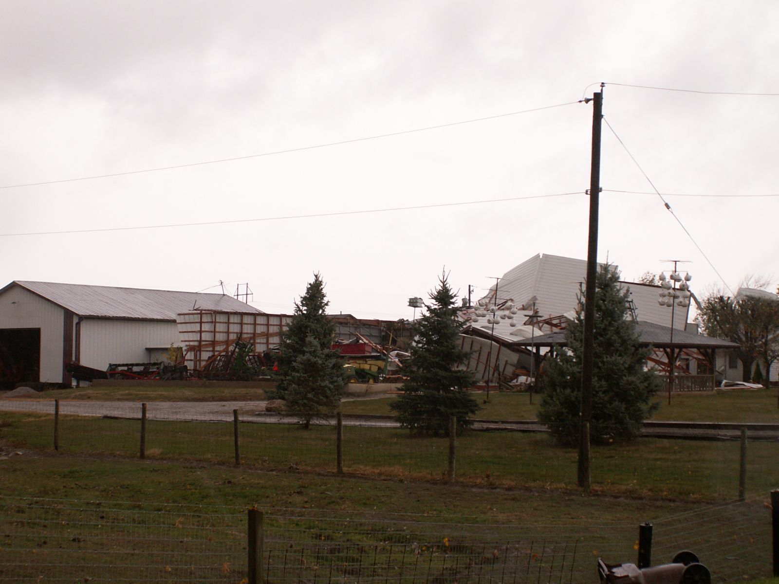
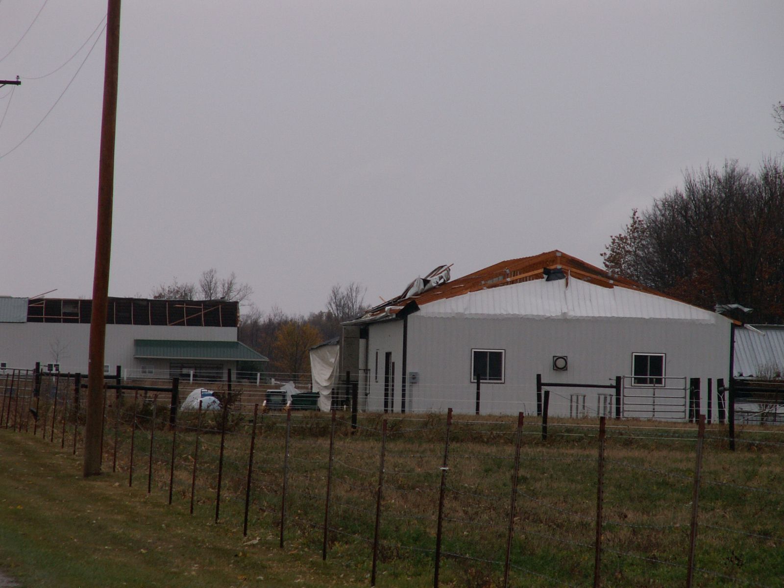
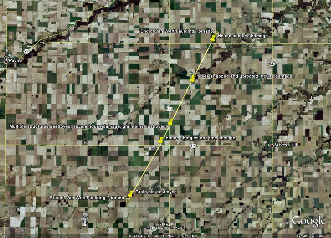
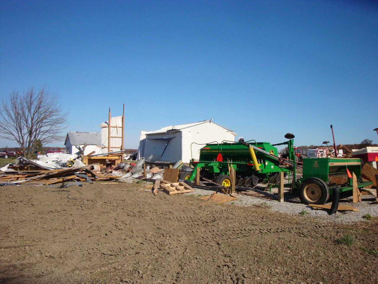
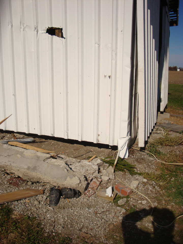
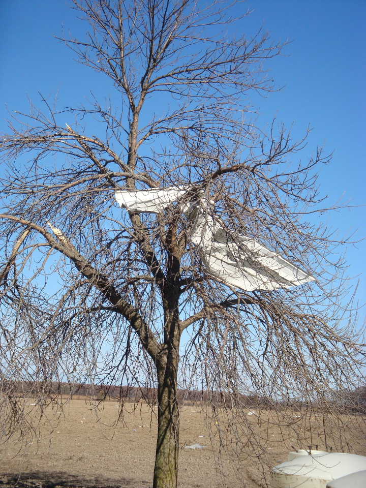
...PRELIMINARY EF1 TORNADO IN VAN WERT AND PAULDING COUNTIES...

A NATIONAL WEATHER SERVICE STORM SURVEY TEAM HAS EXAMINED DAMAGE IN NORTHERN
VAN WERT COUNTY OHIO INTO CENTRAL PAULDING COUNTY OHIO AND FOUND EVIDENCE OF AN
EF1 TORNADO.

THE TORNADO BEGAN ON JOHN BROWN ROAD ABOUT ONE HALF MILE SOUTH OF
THE VAN WERT-PAULDING COUNTY LINE...ENDING 0.2 MILES NORTH
OF BROUGHTON NEAR BETTS ROAD. DAMAGE PATH LENGTH WAS ABOUT NINE AND
ONE QUARTER MILES AND MAXIMUM DAMAGE WIDTH WAS AROUND 350 YARDS WIDE. AS THE
TORNADO TOUCHED DOWN...A GRAIN SILO WAS DESTROYED. THE TORNADO
TRAVELED NORTHEAST THROUGH THE TOWN OF HAVILAND...WERE A GARAGE DOOR WAS
BLOWN IN AND NUMEROUS HOUSES HAD SHINGLE AND TREE DAMAGE. FURTHER NORTHEAST...
TWO BARNS AND MULTIPLE GRAIN BINS WERE DESTROYED. A LARGE DOOR FROM A THIRD BARN
WAS RIPPED OFF...AND A HOUSE NEAR THIS BARN SUSTAINED DAMAGE. DEBRIS FROM THE
BARNS WAS FOUND ONE HALF MILE TO THE NORTHEAST. FURTHER NORTHEAST NEAR COUNTY
ROADS 117 AND 72...TWO LARGE TREES WERE UPROOTED AND A HOUSE SUSTAINED
WINDOW AND ROOF DAMAGE. THE TORNADO MOVED NORTHEAST INTO THE TOWN
OF BROUGHTON...WHERE A HOUSE SUSTAINED DAMAGE AND TREES WERE DAMAGED.
DEBRIS WAS FOUND IN A FIELD TO THE NORTHEAST WHERE THE TORNADO THEN LIFTED.

WIND SPEEDS ASSOCIATED WITH AN EF1 TORNADO RANGE FROM 85 TO 110 MPH. MAXIMUM
ESTIMATED WINDS ASSOCIATED WITH THIS TORNADO WERE AROUND 105 MPH.
Here are some pictures of the damage sustained in Paulding County.

(Photo courtesy of Randy Shaffer, Paulding Co. EM)
(Photo courtesy of Randy Shaffer, Paulding Co. EM)
(Photo courtesy of Randy Shaffer, Paulding Co. EM)
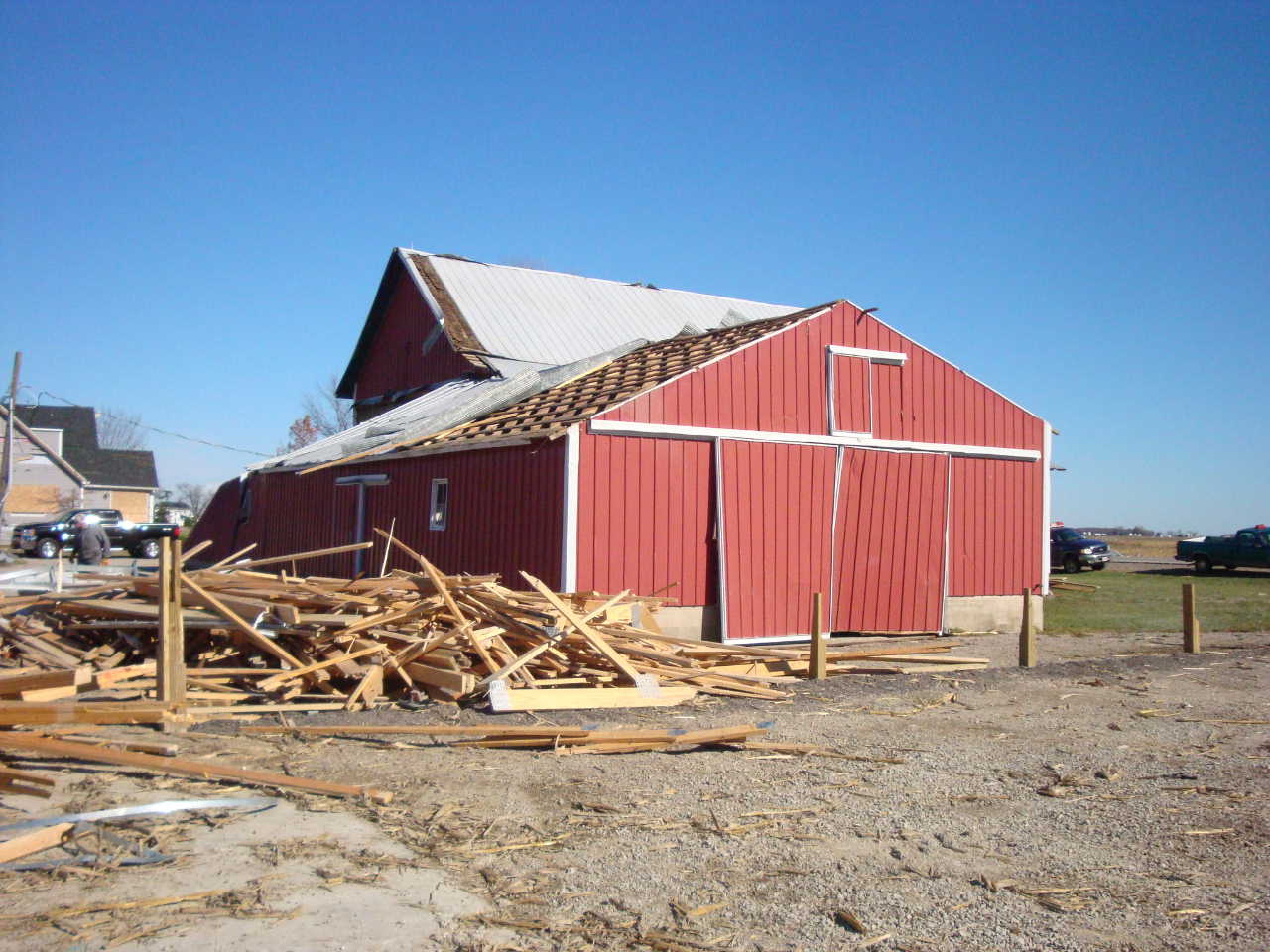
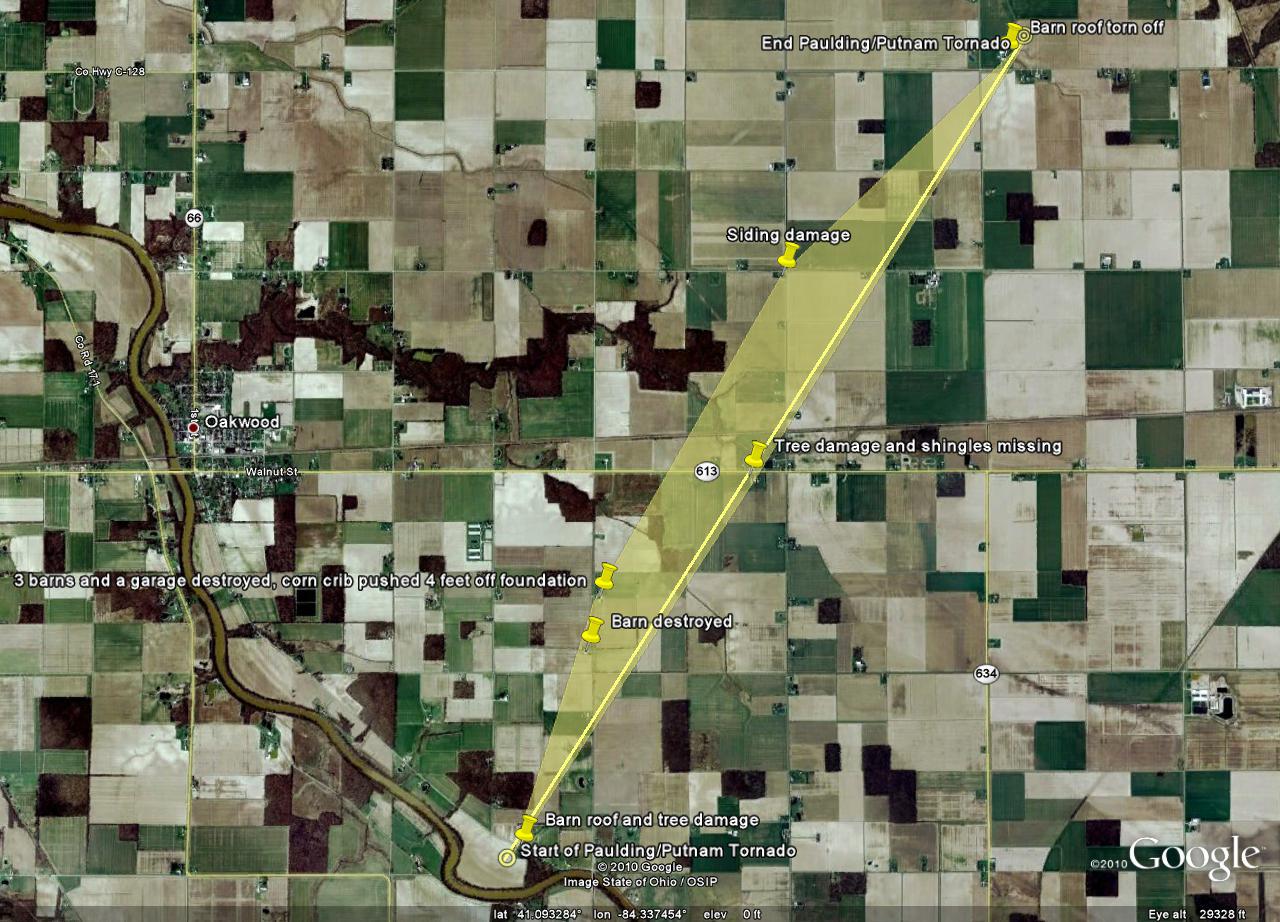
...PRELIMINARY EF1 TORNADO IN PAULDING AND PUTNAM COUNTIES...

A NATIONAL WEATHER SERVICE STORM SURVEY TEAM HAS EXAMINED DAMAGE IN
EASTERN PAULDING COUNTY OHIO INTO NORTHWEST PUTNAM COUNTY OHIO
AND FOUND EVIDENCE OF AN EF1 TORNADO.

THE TORNADO BEGAN ON COUNTY ROAD 205 BETWEEN COUNTY ROAD 263 AND
TOWNSHIP HIGHWAY T-211 IN PAULDING COUNTY...ENDING JUST NORTH OF
TOWNSHIP ROAD D BETWEEN TOWNSHIP HIGHWAY 23 AND 22 IN PUTNAM
COUNTY. DAMAGE PATH LENGTH WAS ABOUT FIVE MILES AND MAXIMUM
DAMAGE WIDTH WAS AROUND 175 YARDS. AS THE TORNADO TOUCHED
DOWN...A BARN ROOF WAS DAMAGED ALONG WITH A FEW TREES. THE TORNADO
MOVED NORTHEAST AND DESTROYED A BARN ON COUNTY ROAD 263 JUST NORTH
OF COUNTY ROAD 86 NEAR THE PAULDING-PUTNAM COUNTY LINE. FURTHER
NORTH...THREE BARNS AND A GARAGE WERE DESTROYED. A CORN CRIB WAS
PUSHED FOUR FEET OFF OF ITS FOUNDATION. DEBRIS FROM THE GARAGE AND
BARNS WAS FOUND UP TO A ONE HALF MILE TO THE NORTHEAST. FURTHER
NORTHEAST ON STATE ROUTE 613 IN HARTSBURG...MINOR TREE DAMAGE WAS
FOUND ALONG WITH A FEW HOUSES WITH SHINGLE DAMAGE. AT THE
INTERSECTION OF COUNTY ROAD 24 AND COUNTY HIGHWAY E...A HOUSE
RECEIVED SIDING DAMAGE. THE TORNADO MOVED NORTHEAST NEAR THE
INTERSECTION OF TOWNSHIP HIGHWAY 23 AND TOWNSHIP ROAD D...WHERE A
BARN ROOF WAS TORN OFF. DEBRIS WAS FOUND IN A FIELD TO THE
NORTHEAST WHERE THE TORNADO LIFTED.

WIND SPEEDS ASSOCIATED WITH AN EF1 TORNADO RANGE FROM 85 TO 110
MPH. MAXIMUM ESTIMATED WINDS ASSOCIATED WITH THIS TORNADO WERE
AROUND 100 MPH.
Here are a few pictures of the damage associated with this tornado.

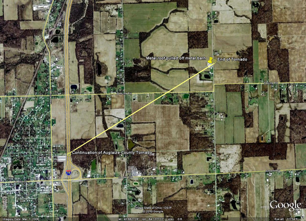
...PRELIMINARY EF0 TORNADO IN ALLEN COUNTY OHIO...

A NATIONAL WEATHER SERVICE STORM SURVEY TEAM HAS EXAMINED DAMAGE IN
SOUTHERN ALLEN COUNTY OHIO AND FOUND EVIDENCE OF AN EF0 TORNADO.

THIS IS A CONTINUATION OF THE AUGLAIZE COUNTY TORNADO. THE TORNADO
TOUCHED BACK DOWN 1.6 MILESTO THE NORTHEAST OF THE LAST DAMAGE IN
CRIDERSVILLE AT APPROXIMATELY 1159 AM EDT. THE LOCATION WAS ALONG
MCLEAN RD NORTH OF NATIONAL RD. ABOUT A QUARTER OF A METAL ROOF WAS
PULLED OFF THE EAST SIDE OF A METAL BARN. THE PATH LENGTH WAS ABOUT
130 FT WITH A MAXIMUM WIDTH OF 50 FEET. NO DEATHS OR INJURIES. THE
DAMAGE WAS RATED AS EF0.

WIND SPEEDS ASSOCIATED WITH AN EF0 TORNADO RANGE FROM 65 TO 85 MPH.
10/28/10 SLL/LF/SW/CEO
Hazards
Heat Related
Winter Related
Watch/Warning
Outlook
Storm Reports
Storm Prediction Center
Submit a Report
Event Ready
Climate
CoCoRaHS
FWA Daily
SBN Daily
FWA Monthly
SBN Monthly
Cliplot
Spring Frost Climatology
Fall Frost Climatology
Severe Climatology
Tornado Climatology
Local Information
Public Information Statement
Probabilistic Snowfall
Storm Data
Skywarn
COOP
Our Office
WSR-88D
Headline Criteria
NOAA Weather Radio
Weather History
Social Media Feeds
Weather Events Page
US Dept of Commerce
National Oceanic and Atmospheric Administration
National Weather Service
Northern Indiana
7506 E 850 N
Syracuse, IN 46567
574-834-1104
Comments? Questions? Please Contact Us.