An isolated supercell developed over Fulton County, Indiana around 4:00 PM EDT on Friday, June 19 and went on to produce grapefruit sized hail in the Rochester area around 4:50 PM EDT. This storm was a textbook classic supercell that interacted with and followed a northwest to southeast oriented outflow boundary during its roughly 2.5 hour lifecycle. This storm produced a brief funnel cloud but no tornado. Though intense supercells such as this one occur with somewhat less frequency than other types of severe weather in this area, these supercell storms are known to produce some of the most extreme severe weather events.
Mesoscale Environment
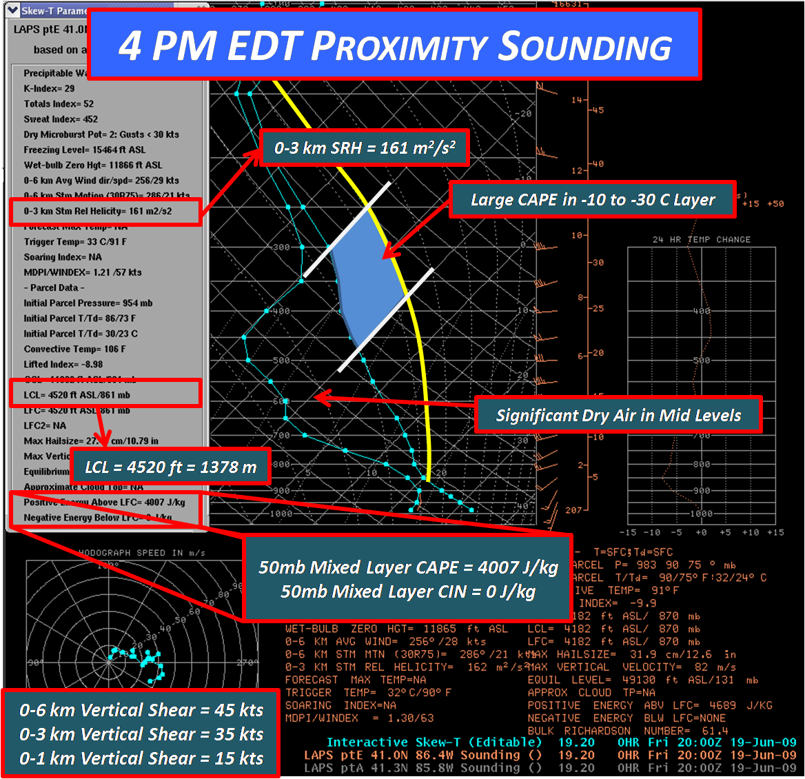
The sounding below is a model analysis for 4:00 PM EDT near the location of the developing supercell. The sounding was modified to adjust surface temperature and dewpoint to observed conditions in the near storm environment. Parameters and indices were then calculated by lifting a mixed layer parcel from the lowest 50 millibars. There are several things to note on this sounding. The large amount of CAPE (a measure of instability in the atmosphere) and lack of convective inhibition (CIN) in a moderately sheared environment would be very favorable for strong, rotating updrafts and supercells. Another feature of note on the sounding was the large CAPE in the -10 to -30 C layer, revealing an enhanced potential for large hail. Modest 0-3 km storm relative helicity exists in this sounding, but values above 250-300 m2/s2 would be more desirable for tornado formation. LCL heights of nearly 1400 meters mean the bases of storms would be fairly high, and possibly limit rotation in the lowest parts of the storm from reaching the ground.
.
Storm Initiation
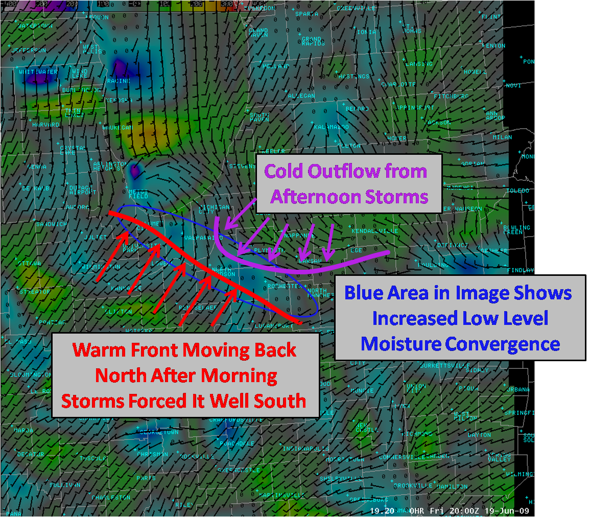
A lack of large scale forcing resulted in little afternoon storm development over the area in spite of favorable conditions. It took the convergence generated by two separate boundaries to finally sustain an isolated storm over western Fulton County. A strong line of storms that moved through early in the morning pushed a boundary all the way south of Lafayette, Indiana. This stable low level air prevented much in the way of severe weather for the first part of the afternoon. However, elevated convection was able to form around midday near the Indiana/Michigan line above this surface cold pool. This convection pushed a strong outflow boundary south through northern Indiana. At the same time, the early morning boundary was being mixed north as a warm front as afternoon heating overcame the stable low level air. As these boundaries approached each other, local mass and moisture convergence was maximized and hence enough forcing was present to initiate deep convection (a thunderstorm).
Why Did this Storm Become Severe While Others Failed?
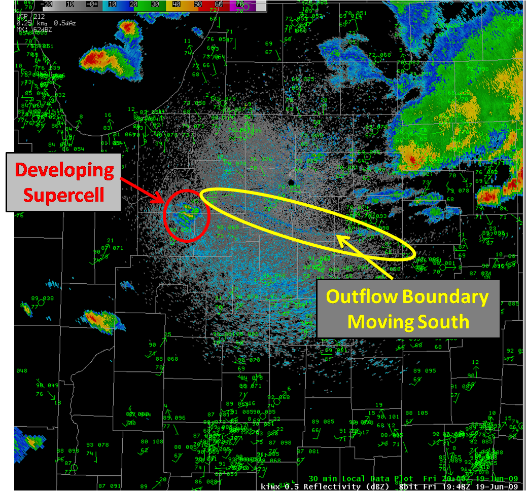
Several other storms tried to fire along the warm front in the afternoon. Conditions appeared quite favorable for any updraft that reached its level of free convection to develop rotation and become severe. However, none of these storms could sustain themselves long enough to reach severe limits. The outflow boundary sinking south from afternoon convection proved to be the difference maker on the Fulton County supercell. The strong low level forcing for ascent provided by the boundary kept surface parcels accelerating vertically. Another benefit of the boundary was that increased vorticity generated along the boundary allowed the updraft to immediately begin rotating, protecting it from any mid level dry air entrainment and a strong belt of mid level westerly winds that may have toppled a non-rotating updraft. The storm "latched" onto this boundary and followed it until the storm's death.
Radar Signatures
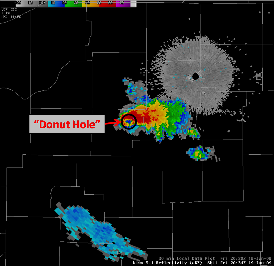
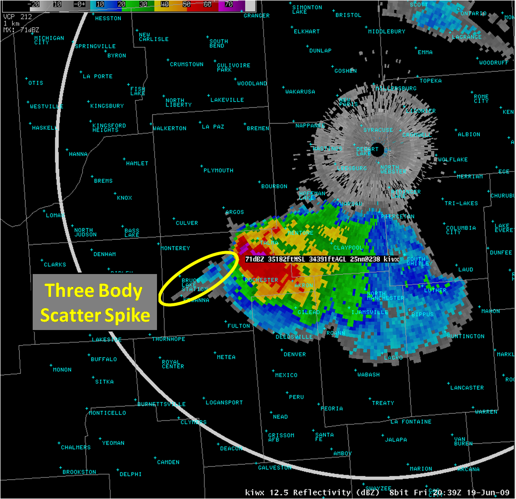
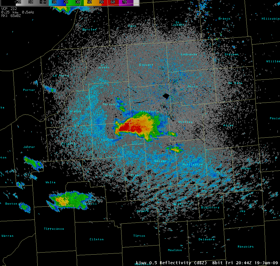
As this supercell slid southeast along the boundary, several classic radar features were observed including: a hook echo; a well defined rear flank downdraft (RFD); a bounded weak echo region (BWER); a three body scatter spike; a v notch; and a strong mid level velocity couplet of 87 knots gate to gate. The first image below shows what is refered to as a "donut hole." This indicates that very little precipitation is entering the rotating updraft. The second images shows a three body scatter spike, a near certain sign of large hail. This signature occurred immediately preceding the grapefruit sized hail report in the Rochester area. The third image shows the hook echo as the storm rides right along the outflow boundary.
Hail Photos
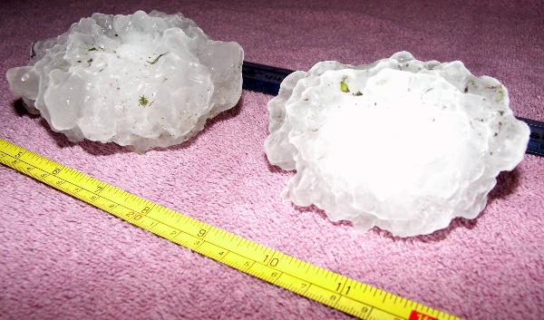
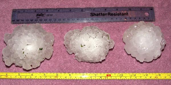
Thomas Hayden, a Rochester area resident, was able to capture some of the grapefruit sized hail stones. The photos below show the gigantic size of the stones that Hayden said were taking down small branches as they fell.
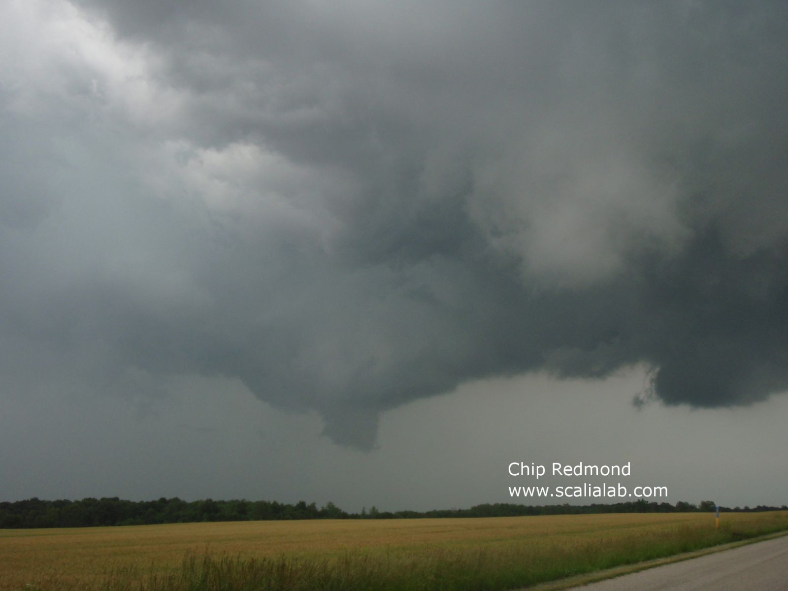
Storm Chaser Intercept
Christopher Redmond, an Ohio University meteorology student was storm chasing and took several impressive photographs of this supercell. The picture below shows a well developed funnel cloud that never was able to reach the ground. Several other pictures and his analysis of the supercell can be found by clicking on this link.
Why was there No Tornado?
A very intense supercell moving along an outflow boundary in a favorable environment would be an excellent candidate for tornado development. So why were there no tornadoes from this supercell? A few reasons are surmised. The reasons are different depending on which side of the boundary the storm existed on as about halfway through the supercell's lifecycle, it moved across a boundary, changing the near storm environment significantly. On the warmer south side of the boundary, some of the blame lies with relatively high LCL heights (cloud bases). Temperatures that soared to around 90 created a nearly 20 degree separation from the lower 70s dew points. This kept cloud bases slightly higher than desired for tornado formation. A funnel like the one seen above may have been on the ground if dew points were 5-8 degrees higher. Only modest values of environmental helicity due in part to weak low level winds and slow storm motion also were likely contributing factors to the lack of tornado production south of the boundary. When the storm moved north of the boundary, into the cooler air, the low level "spin" in the environment became much more favorable, however the near surface air was much cooler and more stable, precluding a circulation from developing in the lowest few hundred feet. Dry air in the mid levels may have also played a factor as the rear flank downdraft appeared to quickly swing around and occlude the low level circulation. As the storm crossed the boundary, it also appeared that a new storm fired on the tip of the hook echo, apparently disrupting the low level circulation for at least a period of time.
Simpson

