Severe thunderstorms brought damaging winds and large hail to much of the Northern Indiana forecast area. The hardest hit areas were South Bend and Mishawaka, where hail to the size of baseballs was observed. The extremely large hail did extensive damage to cars, buildings, and foliage. Numerous cars had windshields shattered along with severe body damage, especially in the Indian Lakes apartment complex. Gurley Leep Buick had a large inventory of cars with damage and expects a large dollar value with the loss.
 |
 |
|
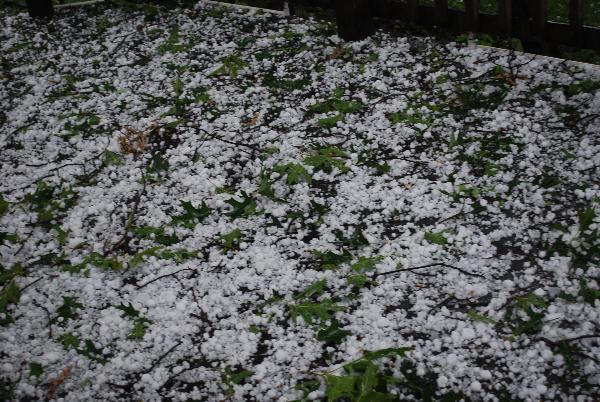 |
Photos Courtesy of WSBT TV South Bend |
|
 |
 |
|
 |
Photos Courtesy of WNDU TV South Bend |
|
 |
| Water vapory imagery helps forecasters identify upper level troughs. Troughs can be identified be areas of extremely dry air aloft, indicated by reddish brown. The arrows indicate speed maxima associated with two shortwave troughs. Strong lift and cooling are found on the nose of the jet, which helps support thunderstorm development. |
Radar data from the event confirms the classic three body scatter signature (images below) that is present with large hail (typically golf ball or larger). This signature was observed up to near the top of the thunderstorm at 29,000 ft. For more information on three body scatter spikes click here. Extremely dry air aloft combined with efficient ice production helped support damaging winds along with the large hail.
 |
 |
| Radar scan at approximately 29,000 ft. Large hail is evident by the strong returns aloft (66 dbz). The presence of a three body scatter spike (lobe of blue extending northwest from the red core) further confirms the presence of large hail. | Five minutes after the previous image, the intense core can be seen descending down toward Mishawaka. The three body scatter spike is even more pronounced, extending toward the northwest. Core returns are now at 71 dbz, indicating the presence of hail. |
This particular thunderstorm was one in a large complex that developed ahead of a cold front Sunday the 15th of June. A very strong upper level shortwave trough (see water vapor image below) was key to the intense nature of the thunderstorms Sunday afternoon. The trough forced lift and cooling aloft, further destabilizing the atmosphere. The strong winds associated with the upper level trough allowed for increased wind shear, supporting intense updrafts. This was a very interesting event, in that hail of this size is unusual in this area, as only 21% of all severe hail reports in the Northern Indiana forecast area are golf ball or larger (reports back to 1955)...and of that 21% only 19% are larger than golf ball.

