Three Tornadoes Confirmed from April 26th Severe Weather Event
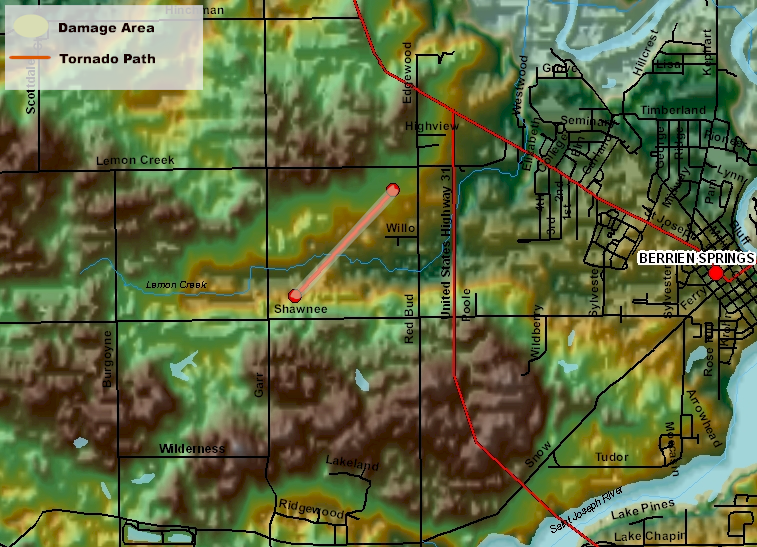
The Berrien county Michigan Emergency Management office and the Northern Indiana National Weather Service office have confirmed a tornado touchdown in Berrien Springs Michigan in central Berrien county. This touchdown occurred on the evening of April 26th. Tornado warnings were in effect for Berrien county at the time of the touchdown.
This tornado was on the ground for approximately 3/4 of a mile from near the intersection of Shawnee and Garr roads to near the intersection of Lemon Creek road and Redbud Trail. The path width was about 50 yards wide. Several softwood trees were snapped and some minor damage to buildings occurred. This damage is consistent with an EF1 rating on the Enhanced Fujita Scale with maximum winds estimated at 90 mph.
The National Weather Service would like to thank everyone involved in finding and reporting this damage...including local media and emergency management.
______________________________________________________________________________________________
A STORM SURVEY WAS CONDUCTED BY THE NATIONAL WEATHER SERVICE ACROSS
NORTHEAST LAPORTE COUNTY ON FRIDAY...APRIL 27TH. THE SURVEY CONCLUDED
THAT TWO SEPARATE TORNADO TOUCHDOWNS OCCURRED ACROSS NORTHEAST
LAPORTE COUNTY LATE THURSDAY AFTERNOON...APRIL 26TH.
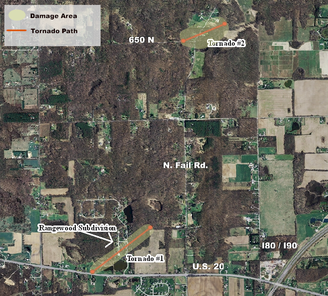
THE FIRST TORNADO TOUCHDOWN OCCURRED AT 408 PM CDT JUST EAST OF
RANGE ROAD AND NORTH OF U. S. 20...OR WITHIN THE RANGEWOOD
SUBDIVISION. THE TORNADO WAS ABOUT 100 YARDS WIDE...TRAVELED A
PATH LENGTH OF ABOUT THREE EIGHTHS OF A MILE...AND LASTED FOR ABOUT
2 TO 4 MINUTES. THE TORNADO COMPLETELY DESTROYED A BARN AND UPROOTED
AND SNAPPED OFF TREES. TWO HOMES SUSTAINED SOME DAMAGE...MAINLY DUE
TO THE FALLEN TREES. THE DAMAGED PRODUCED BY THIS TORNADO RATES IT
AS AN EF1 ON THE ENHANCED FUJITA SCALE WITH MAXIMUM WINDS ESTIMATED
AT 90 MPH.
THE SECOND TORNADO TOUCHDOWN OCCURRED AT 418 PM CDT NEAR THE CORNER
OF FAIL ROAD AND 650 NORTH. THIS TORNADO WAS ABOUT 450 YARDS
WIDE...TRAVELED A PATH LENGTH OF ABOUT THREE EIGHTHS OF A
MILE...AND LASTED FOR ABOUT 2 TO 4 MINUTES. THIS TORNADO ALSO
UPROOTED AND SNAPPED OFF TREES...AND CAUSED SOME DAMAGE TO TWO
HOMES. IN ADDITION...A SHERIFFS VEHICLE IN THE AREA AT THE TIME WAS
PICKED UP AND THROWN OVER A FENCE...TRAVELING A DISTANCE OF ABOUT
150 FEET. THE OCCUPANT OF THE VEHICLE SUSTAINED INJURIES. THE
DAMAGE PRODUCED BY THIS TORNADO RATES IT AS A HIGH END EF1 ON THE
ENHANCED FUJITA SCALE WITH MAXIMUM WINDS ESTIMATED AT 110 MPH.
AN EF1 TORNADO ON THE ENHANCED FUJITA SCALE PRODUCES WINDS OF 86 MPH
TO 110 MPH.
FURTHER DETAILED INFORMATION...INCLUDING MAPS AND IMAGES...WILL BE
PROVIDED LATER TODAY AT OUR WEB SITE. VISIT OUR WEB SITE AT
WEATHER.GOV/IWX.
&&
EDDY/HICKMAN/SIMPSON/LASHLEY

