Damage assessment teams from the National Weather Service Forecast Office in Northern Indiana have confirmed two tornado touchdowns occurred during the evening of Monday August 28th. An F1 tornado occurred in
Damage Survey Findings:
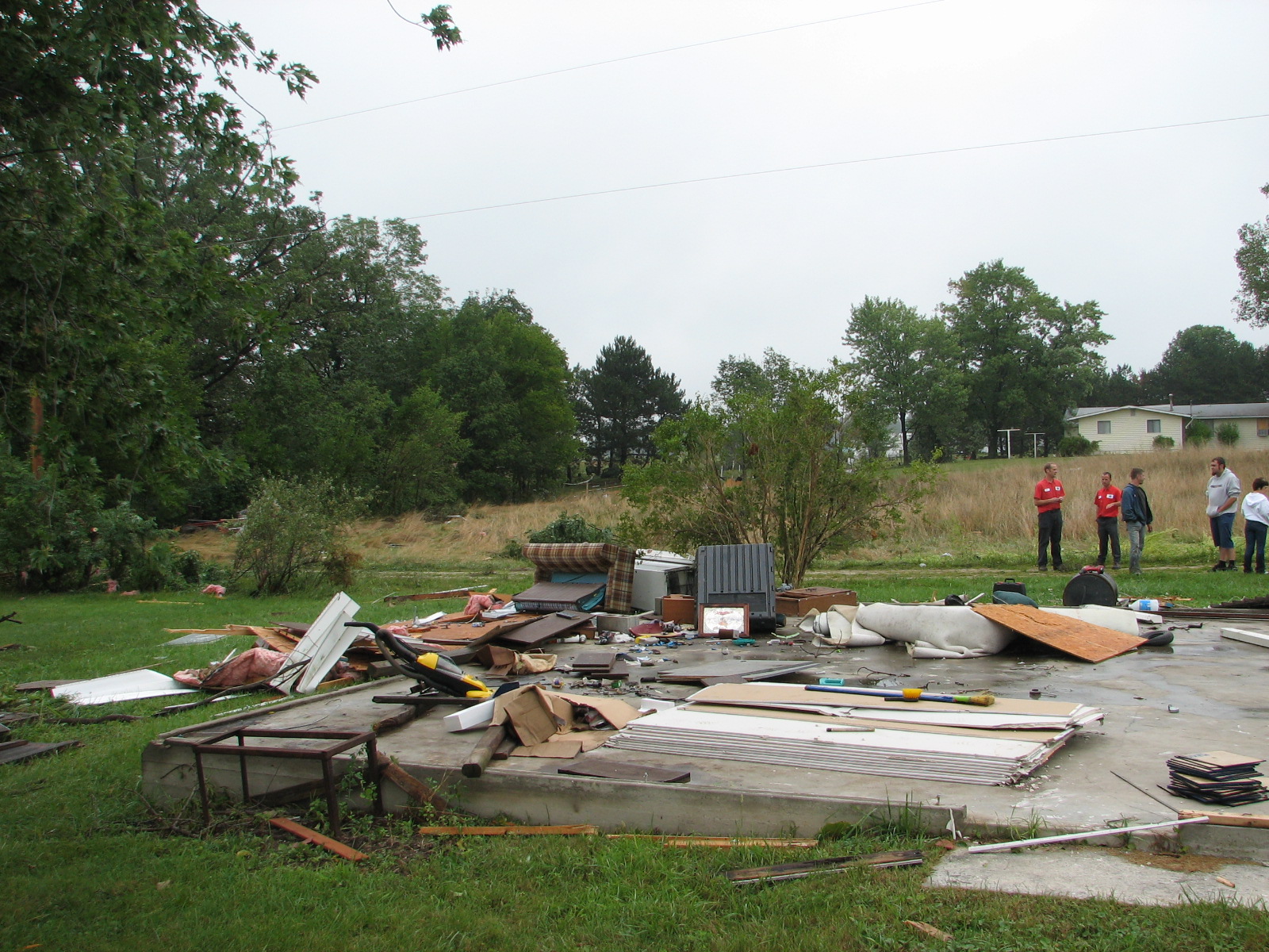
Adams County, Indiana, a tornado occurred about 2 miles east of Decatur . The tornado first touched down near the intersection of U.S. Route 224 and County Road 200 E, in the Briarwood subdivision. The estimated time of the first touchdown, based on eyewitness accounts and radar data, was about 755 pm EDT. The tornado was on the ground for about 2 miles, and was 50 yards wide at its broadest point. Damaged observed by the survey team along the path included uprooted trees, numerous power lines and poles down, several structures with roof and siding damage, one garage destroyed, and a car flipped over onto its top. The damage observed was consistent with an F1 tornado on the Fujita Intensity Scale, with winds estimated at 90 to 100 mph.
In Putnam County, Ohio, a brief tornado occurred about ¾ of a mile northwest of Fort Jennings at about 945 pm EDT. The tornado was on the ground for about 1 mile and traveled northeast, crossing County Road R and Ohio State Route 634. The tornado was about 75 yards wide at its broadest point. Damage observed by the survey team included roof and siding damage to several homes and garages. A pole barn received substantial damage and its metal doors were pushed inward, with a section of roof ripped off. Another barn was completely destroyed. Crop damage was noted with corn knocked down and soy bean fields scoured. The damage observed was consistent with an F1 tornado on the Fujita Intensity Scale, with winds estimated at around 90 mph.
No tornado damage was found in Wells or Allen Counties in Indiana, nor in Van Wert or Paulding Counties in Ohio.
Tornado Track Maps:
Adams County Putnam County


Damage Photos:
The following images are from the Adams County, Indiana tornado.


The following images are from the Putnam County, Ohio tornado.


Meteorological Analysis:
A nearly stationary frontal boundary was draped across northern Indiana and northwest Ohio for much of the day Wednesday. Meanwhile, a compact disturbance in the mid levels of the atmosphere forced a wave of low pressure to develop and move east-northeast along this frontal boundary. The developing warm sector ahead of the low pressure wave, while mostly cloudy, was rain free for much of the day, which allowed modest instability to develop across east central Indiana and west central Ohio.
During the evening near the time of the tornadoes, the wave of low pressure continued to develop eastward along the front into central
As the wave of low pressure approached, a broken line of low topped thunderstorms developed over eastern Indiana . The storms were very weak due to the limited instability, and produced no hail, and very little lightning. A few of the storms did however exhibit some supercell characteristics with weak rotation. Both storms that produced tornadoes developed within the warm sector, and moved northeast across the stationary frontal boundary, strengthening slightly as they did so. As they moved across the frontal boundary, the updraft of the storm was able to ingest the enhanced low level vorticity field along the front, tilt it into the vertical, and stretch it to produce brief, weak tornadoes.

