Northern Indiana
Weather Forecast Office
...F1 TORNADO CONFIRMED IN GRANT COUNTY INDIANA...
A NATIONAL WEATHER SERVICE STORM SURVEY TEAM HAS CONFIRMED AN F1
TORNADO IN GRANT COUNTY INDIANA JUST SOUTHWEST OF THE TOWN OF VAN
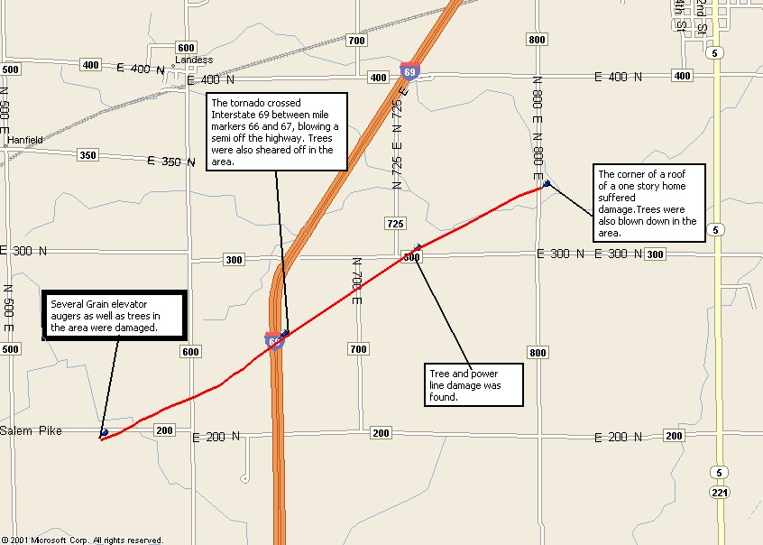
BUREN. THE DAMAGE PATH WAS ABOUT 3 MILES LONG AND 50 YARDS WIDE. THE
TORNADO TOUCHED DOWN JUST SOUTHWEST OF THE INTERSECTION OF COUNTY
ROADS 200N AND 600E AND LIFTED NEAR THE INTERSECTION OF COUNTY ROADS
400N AND 800E. DAMAGE WAS RELATIVELY MINOR WITH THE CORNER OF A ROOF
DAMAGED ON ONE HOME AND SEVERAL TREES AND POWERLINES DOWN. THERE WAS
ALSO DAMAGE TO SEVERAL GRAIN ELEVATOR AUGERS. THE TORNADO ALSO
CROSSED INTERSTATE 69 JUST NORTH OF MILE MARKER 66 WHICH RESULTED IN
A TRUCK BEING BLOWN OFF THE HIGHWAY.

Hazards
Heat Related
Watch/Warning
Outlook
Storm Prediction Center
Storm Reports
Submit a Report
Outdoor Event Watcher
EM Briefing
Current Conditions
Hourly Weather
Surface Observations
Regional Temps/Precip
Precip Reports
Satellite
Climate
CoCoRaHS
FWA Daily
SBN Daily
FWA Monthly
SBN Monthly
Cliplot
Spring Frost Climatology
Fall Frost Climatology
Severe Climatology
Tornado Climatology
Local Information
Public Information Statement
Probabilistic Snowfall
Storm Data
Skywarn
COOP
Our Office
WSR-88D
Headline Criteria
NOAA Weather Radio
Weather History
Social Media Feeds
Weather Events Page
US Dept of Commerce
National Oceanic and Atmospheric Administration
National Weather Service
Northern Indiana
7506 E 850 N
Syracuse, IN 46567
574-834-1104
Comments? Questions? Please Contact Us.

