Northern Indiana
Weather Forecast Office
Synoptic conditions on November 06, 2005...
An intense mid level shortwave rapidly sharpened and took on a negative tilt as it progressed through the Great Lakes. A strong mid level jet of 80 to 90 knots at 500mb developed along the southern periphery of the digging shortwave and contributed to strong deep layer shear. Meanwhile a surface low pressure in the central plains moved northeast along a stationary front and quickly deepened in response to the sharpening mid level shortwave. The rapidly deepening low passed by just to the northwest of the CWA. The rapid deepening aided in keeping the surface flow backed (S or SSE). Strong deep layer shear and impressive low level helicity values (0-1km Helicity 300-400) were able to compensate for minimal CAPE values of 100-500J/kg.
Mesoscale/Stormscale conditions...
A cluster of supercells formed during the evening over Missouri and evolved into a squall line and crossed Illinois as linear forcing strengthened. The line initially weakened due to minimal instability as it entered into the CWA. Some strengthening occured as the line was about 1/3 through the CWA as synoptic scale forcing peaked. The line moved rapidly east through the eastern half of the CWA. Very strong mid level flow contributed to damaging wind potential at the surface. Despite very high values of 0-1km Helicity, tornadoes did not occur this far north, most likely due to a lack of boundary layer instability.
Radar trends and observations...
The squall line was very low topped by the time it reached Indiana, with echo tops of only 10-15 thousand feet. The squall line was broken into small scale segments (which were more perpindicular to the mid level flow) which locally enhanced wind damage. Low level mesocyclones along the leading edge of the squall line also aided in enhancing wind damage in some locations. Forward motion of the line was exceedingly fast, estimated at 70 to 75 mph.
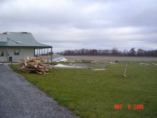
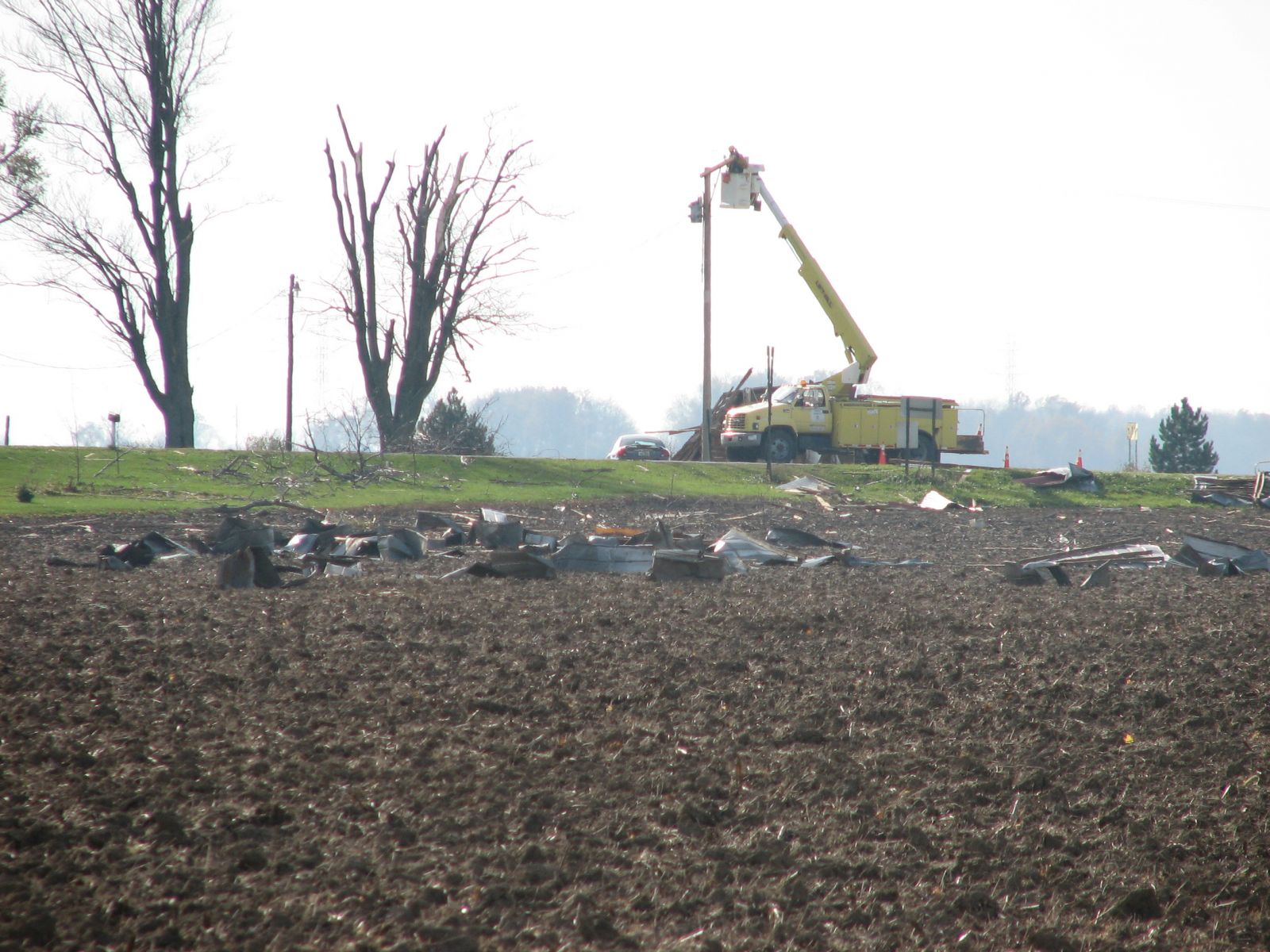
Significant damage...
Grant county - Marion and Upland townships. 10 barns and 3 mobile homes destroyed. Dekalb county - Auburn. 4 homes suffered extensive damage. Paulding county - near Paulding. Several large oak trees blown down with damage to several homes
Widespread reports of of trees and powerlines down were recieved throughout Indiana...mainly east of Indiana Route 25 and south of U.S. Route 30. There were also numerous reports of structural damage to many barns and some homes damaged in areas of east central Indiana south of Fort Wayne. Widspread damage of a similar nature was also reported in much of northwest Ohio. All of the damage reported was consistent with that of strong straight line winds, and no tornadoes were reported in this area.
Click for a summary of wind damage reports
NWUS53 KIWX 071026
LSRIWX

PRELIMINARY LOCAL STORM REPORT...SUMMARY
NATIONAL WEATHER SERVICE NORTHERN INDIANA
526 AM EST MON NOV 07 2005

..TIME...   ...EVENT...      ...CITY LOCATION...     ...LAT.LON...
..DATE...   ....MAG....      ..COUNTY LOCATION..ST.. ...SOURCE....
            ..REMARKS..

1200 AM     MARINE TSTM WIND MICHIGAN CITY           41.71N 86.88W
11/06/2005  47 MPH           LA PORTE           IN   MESONET

            MEASURED AT MICHIGAN CITY GLERL SITE

0235 AM     TSTM WND DMG     6 ENE ROCHESTER         41.09N 86.09W
11/06/2005                   FULTON             IN   LAW ENFORCEMENT

            SEVERAL TREE LIMBS DOWN NEAR 900E 500N.

0235 AM     HAIL             10 E LOGANSPORT         40.75N 86.17W
11/06/2005  0.75 INCH        CASS               IN   TRAINED SPOTTER

0240 AM     TSTM WND DMG     4 SSE SYRACUSE          41.37N 85.72W
11/06/2005                   KOSCIUSKO          IN   NWS EMPLOYEE

            LARGE TREE AND POWER LINES DOWN ON STATE ROAD 13.

0240 AM     TSTM WND DMG     9 N PERU                40.88N 86.07W
11/06/2005                   MIAMI              IN   LAW ENFORCEMENT

            TRAILER FLIPPED OVER ALONG US 31 JUST NORTH OF ROUTE 16.

0240 AM     TSTM WND DMG     PERU                    40.75N 86.07W
11/06/2005                   MIAMI              IN   LAW ENFORCEMENT

            TREES AND POWERLINES DOWN THROUGHOUT THE COUNTY.

0243 AM     TSTM WND DMG     1 S SILVER LAKE         41.06N 85.89W
11/06/2005                   KOSCIUSKO          IN   LAW ENFORCEMENT

            TREES DOWN ACROSS ROUTE 15.

0248 AM     HAIL             SWAYZEE                 40.51N 85.82W
11/06/2005  0.88 INCH        GRANT              IN   PUBLIC

0250 AM     TSTM WND DMG     MARION                  40.55N 85.67W
11/06/2005                   GRANT              IN   EMERGENCY MNGR

            8 TO 10 BARNS AND 3 MOBILE HOMES DESTROYED. HOUSE
            SUFFERED SEVERE WINDOW DAMAGE. THIS OCCURRED IN THE
            TOWNSHIPS OF MARION AND UPLAND.

0250 AM     TSTM WND DMG     LOGANSPORT              40.75N 86.36W
11/06/2005                   CASS               IN   TRAINED SPOTTER

            TREE REPORTED KNOCKED DOWN.

0250 AM     TSTM WND DMG     WABASH                  40.80N 85.83W
11/06/2005                   WABASH             IN   LAW ENFORCEMENT

            PORCH BLOWN OFF HOUSE...TREES AND POWERLINES DOWN.

0305 AM     TSTM WND DMG     HUNTINGTON              40.88N 85.51W
11/06/2005                   HUNTINGTON         IN   EMERGENCY MNGR

            TREES AND POWERLINES DOWN COUNTYWIDE.

0315 AM     TSTM WND DMG     HARTFORD CITY           40.45N 85.37W
11/06/2005                   BLACKFORD          IN   LAW ENFORCEMENT

            POWERLINES DOWN COUNTYWIDE

0315 AM     TSTM WND DMG     7 NE HARTFORD CITY      40.52N 85.28W
11/06/2005                   BLACKFORD          IN   LAW ENFORCEMENT

            LARGE TREE DOWN.

0319 AM     TSTM WND DMG     BLUFFTON                40.74N 85.17W
11/06/2005                   WELLS              IN   LAW ENFORCEMENT

            TREES AND POWERLINES DOWN COUNTYWIDE.

0320 AM     TSTM WND DMG     6 SW BLUFFTON           40.68N 85.25W
11/06/2005                   WELLS              IN   EMERGENCY MNGR

            ROOFS BLOWN OFF THREE HOUSES ALONG WITH FIVE LARGE TREES
            DOWN IN CHESTER TOWNSHIP.

0325 AM     TSTM WND DMG     COLUMBIA CITY           41.16N 85.48W
11/06/2005                   WHITLEY            IN   AMATEUR RADIO

            TREE KNOCKED DOWN OVER ST RD 9. TREES REPORTED KNOCKED
            DOWN DOWNTOWN.

0330 AM     TSTM WND DMG     2 W DECATUR             40.83N 84.97W
11/06/2005                   ADAMS              IN   EMERGENCY MNGR

            NUMEROUS TREES DOWN. BARN BLOWN OVER.

0330 AM     TSTM WND DMG     FORT WAYNE              41.07N 85.14W
11/06/2005                   ALLEN              IN   TRAINED SPOTTER

            3 FOOT DIAMETER OAK TREE FELL ON PICK-UP TRUCK CAUSING
            EXTENSIVE DAMAGE. LARGE TREE DOWN ON PORCH.

0332 AM     TSTM WND DMG     DUNKIRK                 40.37N 85.21W
11/06/2005                   JAY                IN   LAW ENFORCEMENT

            ROOF DAMAGE TO A BUILDING.

0335 AM     TSTM WND GST     NEW HAVEN               41.07N 85.03W
11/06/2005  60 MPH           ALLEN              IN   AMATEUR RADIO

0337 AM     TSTM WND DMG     ANGOLA                  41.64N 85.00W
11/06/2005                   STEUBEN            IN   LAW ENFORCEMENT

            TREES AND POWERLINES DOWN COUNTYWIDE.

0338 AM     TSTM WND DMG     AUBURN                  41.36N 85.06W
11/06/2005                   DE KALB            IN   LAW ENFORCEMENT

            TREES DOWN THROUGHOUT COUNTY. FOUR HOUSES SUFFERED
            EXTENSIVE DAMAGE IN THE CITY OF AUBURN.

0358 AM     TSTM WND DMG     HILLSDALE               41.93N 84.64W
11/06/2005                   HILLSDALE          MI   EMERGENCY MNGR

            REPORTS OF TREES DOWN THROUGHOUT THE COUNTY.

0400 AM     TSTM WND DMG     1 N ANTWERP             41.20N 84.74W
11/06/2005                   PAULDING           OH   EMERGENCY MNGR

            ROOF BLOWN OFF HOUSE TRAILER 100 BLOCK OF US 24.

0400 AM     TSTM WND DMG     ANTWERP                 41.18N 84.74W
11/06/2005                   PAULDING           OH   EMERGENCY MNGR

            25 FOOT PINE TREE DOWN ON HOUSE.

0400 AM     TSTM WND DMG     ANTWERP                 41.18N 84.74W
11/06/2005                   PAULDING           OH   EMERGENCY MNGR

            LARGE TREE KNOCKED DOWN AT INTERSECTION OF 192 AND 45.

0400 AM     TSTM WND DMG     4 NE DEFIANCE           41.32N 84.31W
11/06/2005                   DEFIANCE           OH   LAW ENFORCEMENT

            LARGE LIMBS AND POWERLINES DOWN AROUND THE CITY OF JEWEL.


0400 AM     TSTM WND DMG     3 N ANTWERP             41.22N 84.74W
11/06/2005                   PAULDING           OH   EMERGENCY MNGR

            POLE BARN DESTROYED NEAR THE INTERSECTION OF COUNTY ROADS
            220 AND 45.

0400 AM     TSTM WND DMG     5 NNE PAULDING          41.20N 84.55W
11/06/2005                   PAULDING           OH   EMERGENCY MNGR

            SEVERAL 2 FOOT DIAMETER OAK TREES DOWN AND DAMAGE TO
            SEVERAL HOMES NEAR THE INTERSECTION OF COUNTY ROAD 133
            AND STATE ROAD 111.

0405 AM     TSTM WND DMG     BRYAN                   41.47N 84.55W
11/06/2005                   WILLIAMS           OH   LAW ENFORCEMENT

            TREES AND POWERLINES DOWN COUNTYWIDE.

0410 AM     TSTM WND DMG     1 E VAN WERT            40.86N 84.56W
11/06/2005                   VAN WERT           OH   EMERGENCY MNGR

            ONE METAL BARN DESTROYED AND ONE KNOCKED OVER.

0410 AM     TSTM WND DMG     2 E CONVOY              40.92N 84.67W
11/06/2005                   VAN WERT           OH   EMERGENCY MNGR

            SEMI TRUCK BLOWN OVER ON US 30.

0410 AM     TSTM WND DMG     1 N CONVOY              40.93N 84.71W
11/06/2005                   VAN WERT           OH   EMERGENCY MNGR

            POWER LINES DOWN AND BARN DESTROYED.

0410 AM     TSTM WND DMG     CONVOY                  40.92N 84.71W
11/06/2005                   VAN WERT           OH   EMERGENCY MNGR

            NUMEROUS TREES DOWN ACROSS WESTERN HALF OF VAN WERT
            COUNTY INCLUDING THE CITY OF CONVOY.

0410 AM     TSTM WND DMG     2 E QUINCY              41.94N 84.84W
11/06/2005                   BRANCH             MI   LAW ENFORCEMENT

            TELEPHONE POLES DOWN.

0425 AM     TSTM WND DMG     OTTAWA                  41.02N 84.04W
11/06/2005                   PUTNAM             OH   LAW ENFORCEMENT

            TREES AND POWERLINES DOWN COUNTYWIDE.

0427 AM     TSTM WND DMG     WAUSEON                 41.55N 84.14W
11/06/2005                   FULTON             OH   LAW ENFORCEMENT

            TREES AND POWERLINES DOWN COUNTYWIDE.

0430 AM     TSTM WND DMG     NEW BAVARIA             41.20N 84.17W
11/06/2005                   HENRY              OH   LAW ENFORCEMENT

            TREE AND POWERLINES DOWN.


&&

$$

THOLSTEN
J.Hitchcock
Hazards
Heat Related
Winter Related
Watch/Warning
Outlook
Storm Reports
Storm Prediction Center
Submit a Report
Event Ready
Climate
CoCoRaHS
FWA Daily
SBN Daily
FWA Monthly
SBN Monthly
Cliplot
Spring Frost Climatology
Fall Frost Climatology
Severe Climatology
Tornado Climatology
Local Information
Public Information Statement
Probabilistic Snowfall
Storm Data
Skywarn
COOP
Our Office
WSR-88D
Headline Criteria
NOAA Weather Radio
Weather History
Social Media Feeds
Weather Events Page
US Dept of Commerce
National Oceanic and Atmospheric Administration
National Weather Service
Northern Indiana
7506 E 850 N
Syracuse, IN 46567
574-834-1104
Comments? Questions? Please Contact Us.

