Brief Tornado Touchdown in Kosciusko County July 6, 2005
PUBLIC INFORMATION STATEMENT
NATIONAL WEATHER SERVICE NORTHERN INDIANA
1044 AM EST THU JUL 7 2005
...BRIEF F0 TORNADO IN WESTERN KOSCIUSKO COUNTY ON WEDNESDAY JULY 6
2005...
A STORM SURVEY WAS COMPLETED THURSDAY MORNING BY NATIONAL WEATHER
SERVICE PERSONNEL IN WESTERN KOSCIUSKO COUNTY AFTER RECEIVING
REPORTS OF TREES DOWN...AS WELL AS FUNNEL CLOUDS AND A BRIEF
TOUCHDOWN OF A TORNADO FROM A THUNDERSTORM IN THE AREA BETWEEN
CLUNETTE AND ATWOOD.
A FEW TREES...AS WELL AS SOME CORN STALKS IN AN ADJACENT
FIELD...WERE DAMAGED AS A RESULT OF STRAIGHT LINE WINDS...ESTIMATED
IN THE 60 TO 65 MPH RANGE...ASSOCIATED WITH THE STORM. AT
APPROXIMATELY 545 PM EST...JUST PRIOR TO THE WIND DAMAGE...EYE
WITNESS REPORTS WERE RECEIVED FROM SEVERAL SOURCES OF FUNNEL CLOUDS
AND A BRIEF TORNADO TOUCHDOWN APPROXIMATELY 2 MILES NORTH OF ATWOOD.
THE TOUCHDOWN OCCURRED IN A OPEN FIELD...WITH NO DAMAGE FOUND DURING
THE SURVEY ASSOCIATED WITH IT. IT WAS RATED AN F0 ON THE FUJITA
SCALE...WITH WINDS APPROXIMATELY 40 TO 50 MPH.
$$
LASHLEY/LOGSDON/FISHER
Synopsis of Weather Conditions
A lake breeze boundary developed and moved southeast away from Lake Michigan during the afternoon hours of July 6th. This boundary interacted with an unstable atmosphere, resulting in a thunderstorm developing near South Bend, Indiana. As this storm weakened, an outflow boundary spread south of the storm and intersected the lake breeze boundary in northwestern Kosciusko county around 5 pm EST (Figure 1). The result was a thunderstorm that developed around 510 pm EST and drifted slowly south across the western part of the county. At this point, the storm briefly (less than 5 minutes) exhibited some weak mid level rotation, likely resulting from the boundary interaction (Figure 2). Another outflow boundary was generated from this new storm, moving slowly south, causing another shower to quickly develop (Figure 3). This shower merged with the thunderstorm around 540 pm EST. The combination of the merger and the noted boundaries in the area allowed for a brief period of weak rotation to occur sufficient for a tornado to develop. The tornado was observed to only be on the ground for less than 1 minute. As this storm progressed slowly south, a downburst occurred, with much of the effect being felt in the Hoffman lake area as 60-65 mph winds knocked down some trees and damaged a corn field.
A picture of a funnel that appears to be in contact with the ground (ie: a tornado), was submitted by a weather spotter. The funnel is rather fuzzy in the picture, centered between a group of trees to the left and a high voltage tower to the right (Figure 4).
7/7/05...LF/JAL
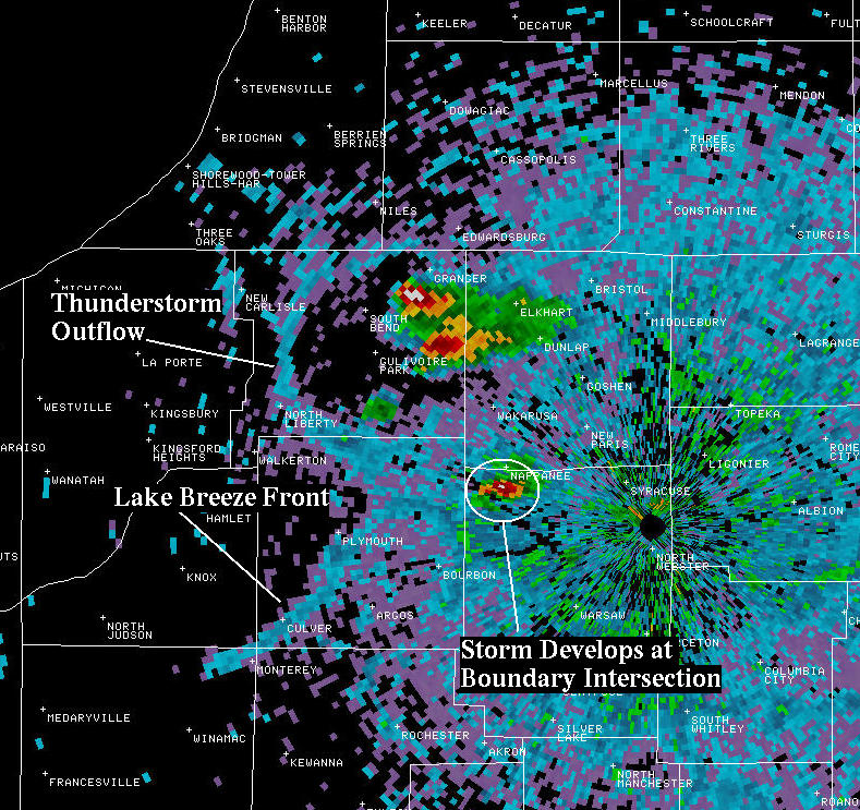 Figure 1: Collision of Lake Breeze and Outflow boundary in NW Kosciusko County |
 Figure 3: New cell development ahead of storm |
 Figure 2: Brief Mid Level Rotation noted about a half hour prior to the touchdown |
 Figure 4: Picture of Weak Tornado (Courtesy Robert Johnson) |

