Prolonged Snow Event Affects Much of the Area
A prolonged period of precipitation occurred across the forecast area beginning Monday Feb 28 with the significant part of the event ending early the morning of March 2, 2005. The precipitation started out as a mixture of rain, freezing rain, sleet and snow across the area. Amounts were generally light with many area roads becoming slippery, causing several accidents, some with injuries. As colder air arrived Monday afternoon, the precipitation changed to all snow as low pressure developed across central Indiana and intensified. The snow developed in response to a combination of the deepening low pressure system and enhancement off Lake Michigan as cold northwest winds strengthened. By 7 am EST Tuesday morning (Mar 1), amounts ranged from nearly 18 inches at Niles in southeast Berrien county to an inch in White county Indiana. The snow continued through much of Tuesday, with much of the snowfall being confined to two dominant bands of lake effect snowfall. As the afternoon progressed and shear increased in response to the passage of a secondary following upper level wave, the bands became more multiple in nature with a larger area seeing less intense snow showers.
Figure 3 below represents a hand contour analysis of coop observer and snow spotter reports for this event. Niles Michigan was the big winner with 17.8 inches reported. A big thank you to all of those who called in their reports!
|
The radar images below (Figures 1 and 2) show where the two predominant heavy lake effect snow bands setup and persisted. Areas of dark green on the radar images indicate where snow was falling at the rate of 1 to 2 inches per hour.
|

Figure 1 0.5° base reflectivity image from 559 am EST March 1st. This first band resulted in 6 to 10 inches of snowfall before it began lifting eastward later that morning. |
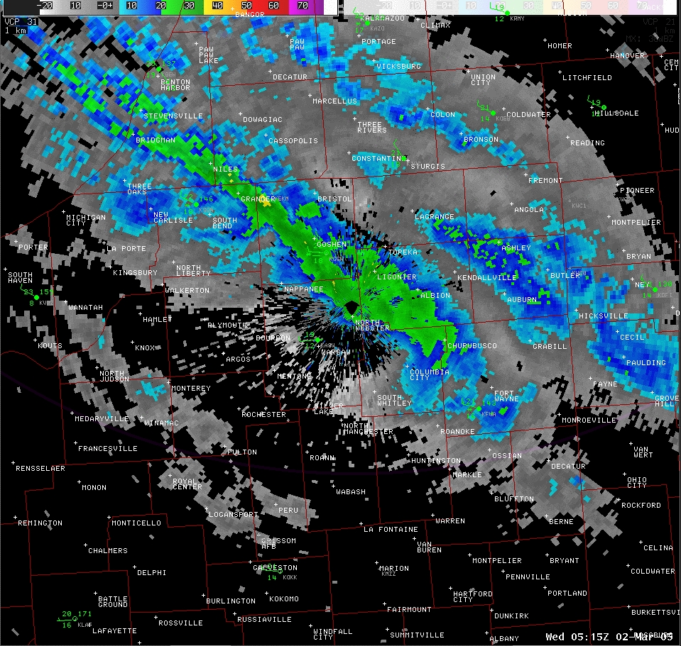
Figure 2 0.5° base reflectivity image from 1215 am EST March 2nd. This second band resulted in 3 to 6 inches of snowfall before it broke up toward 700 am that morning. |
PUBLIC INFORMATION STATEMENT...CORRECTION
NATIONAL WEATHER SERVICE NORTHERN INDIANA
245 AM EST THU MAR 3 2005

A POTENT UPPER LEVEL SYSTEM THAT DUG SOUTHEAST OUT OF CANADA
PRODUCED A GENERAL LIGHT SNOWFALL ACROSS THE REGION DURING MONDAY
AND MONDAY EVENING.  HOWEVER...DURING THE OVERNIGHT HOURS LAKE
ENHANCEMENT FROM THE RELATIVELY WARM WATERS OF LAKE MICHIGAN BEGAN
TO INCREASE SNOWFALL RATES ACROSS NORTHWEST INDIANA AND SOUTHWEST
MICHIGAN.  BY EARLY TUESDAY MORNING LAKE EFFECT SNOWS BECAME FIRMLY
ESTABLISHED AS A SINGLE DOMINANT BAND FORMED DOWN THE LONG AXIS OF
THE LAKE.  THIS BAND PRODUCED HEAVY SNOW ACROSS BERRIEN AND WESTERN
CASS COUNTIES IN MICHIGAN AS WELL AS ST. JOSEPH...WESTERN ELKHART
AND CENTRAL KOSCIUSKO COUNTIES IN INDIANA.  THIS BAND WEAKENED AS
THE DAY PROGRESSED...HOWEVER BY LATER TUESDAY NIGHT MULTIPLE LAKE
BANDS DEVELOPED ACROSS THE AREA.  THE STRONGEST OF THESE BANDS
STRETCHED FROM BERRIEN AND EXTREME SOUTHWESTERN CASS COUNTIES IN
MICHIGAN THROUGH NORTHWESTERN ST. JOSEPH...CENTRAL ELKHART...WESTERN
NOBLE AND NORTHERN KOSCIUSKO COUNTIES IN INDIANA. SNOWFALL RATES OF
1 TO 2 INCHES PER HOUR WHERE REPORTED WITHIN THIS BAND. WEAKER BANDS
WHERE NOTED ACROSS ST. JOSEPH COUNTY MICHIGAN AND LAGRANGE COUNTY
INDIANA AS WELL AS LA PORTE COUNTY INDIANA.

HERE ARE THE LATEST REPORTED SNOWFALL AMOUNTS...

LOCATION             COUNTY      TOTAL SNOWFALL

...SOUTHWEST LOWER MICHIGAN...

NILES                BERRIEN         17.8
BUCHANAN             BERRIEN         15.0
EAU CLAIRE           BERRIEN         14.0
STEVENSVILLE         BERRIEN         10.6
BENTON HARBOR        BERRIEN         10.0
BERRIEN SPRINGS      BERRIEN          8.2
W.CASS COUNTY        CASS            12.0
UNION                CASS             5.0
CASSOPOLIS           CASS             5.0
LITCHFIELD           HILLSDALE        5.8
COLDWATER            BRANCH           1.5
QUINCY               BRANCH           1.0
STURGIS              ST. JOSEPH       4.0
WHITE PIGEON         ST. JOSEPH       2.3
THREE RIVERS         ST. JOSEPH       1.0


...NORTHERN INDIANA...

GRANGER              ST. JOSEPH      13.0
SOUTH BEND AIRPORT   ST. JOSEPH       6.7
MISHAWAKA            ST. JOSEPH       6.0
GOSHEN               ELKHART          7.5-9.5
ELKHART              ELKHART          8.5
NAPPANEE             ELKHART          10.5
WAKARUSA             ELKHART          6.0
SIMONTON LAKE        ELKHART          4.5
MIDDLEBURY           ELKHART          5.0
ROLLING PRAIRIE      LA PORTE         9.2
LA PORTE             LA PORTE         6.5
MICHIGAN CITY        LA PORTE         4.5
FREMONT              STEUBEN          5.7
SALEM CENTER         STEUBEN          5.3
ANGOLA               STEUBEN          3.0
PLEASANT LAKE        STEUBEN          3.0
ASHLEY               DEKALB           6.0
WATERLOO             DEKALB           2.5
AUBURN               DEKALB           2.0
NORTH JUDSON         STARKE           2.0
BREMEN               MARSHALL         6.0
ATWOOD               KOSCIUSKO       10.0
SYRACUSE/NWS         KOSCIUSKO        6.4
WINONA LAKE          KOSCIUSKO        5.0
WARSAW               KOSCIUSKO        5.0
CROMWELL             NOBLE            6.0
LAOTTO               NOBLE            3.0
KENDALLVILLE         NOBLE            2.0
ROCHESTER            FULTON           2.0
AKRON                FULTON           1.5
COLUMBIA CITY        WHITLEY          5.8
SOUTH WHITLEY        WHITLEY          5.0
PEABODY              WHITLEY          3.0
FORT WAYNE           ALLEN            2.5-3.0
FORT WAYNE AIRPORT   ALLEN            2.0
HEADLEE              WHITE            1.8
LOGANSPORT           CASS             2.1
NORTH MANCHESTER     WABASH           2.0
HUNTINGTON           HUNTINGTON       4.8
OSSIAN               WELLS            2.4
BLUFFTON             WELLS            1.0
DECATUR              ADAMS            2.0
MARION               GRANT            2.0
PORTLAND             JAY              1.0


...NORTHWEST OHIO...

DESHLER              HENRY            5.0
PANDORA              PUTNAM           4.0
COLUMBUS GROVE       PUTNAM           1.8
HICKSVILLE           DEFIANCE         3.1
DEFIANCE             DEFIANCE         2.0
VAN WERT             VAN WERT         1.6
GROVER HILL          PAULDING         4.0
WAUSEON              FULTON           2.0


THE NATIONAL WEATHER SERVICE IN NORTHERN INDIANA THANKS OUR
VOLUNTEER SNOW SPOTTERS FOR THEIR REPORTS. WE ENCOURAGE YOU TO
REPORT YOUR SNOWFALL THROUGHOUT THE WINTER SEASON.

$$
|

Figure 3 Hand contour analysis of storm total snowfall |
|
TH/LF...3/3/05

