Snowstorm on January 22nd, 2005
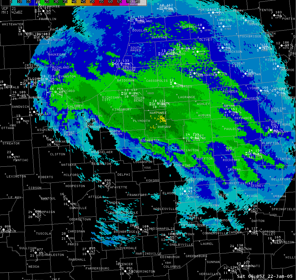
| A major snowstorm developed Friday evening in response to the last in a series of potent "Clippers" dropping out of Canada into the Great Lakes. The heaviest snowbands developed by late evening and continued well into Saturday morning as surface low pressure moving east-southeast out of Illinois intensified. Two dominant mesoscale snowbands (Figures 1 & 2) developed in response and were responsible for the majority of the snow accumulation. |
|
 Figure 2 National Weather Service Composite Reflectivity image from 331 am EST |
These bands resulted in the higher observed accumulations (Figure 3)...especially the first band (Figure 1) late Friday evening which produced 1 to 2 inch per hour snowfall rates...and resulted in a general 4 to 8 inch snowfall with 8 to 12 inches generally along and north of the toll road. Areas south of highway 30 received considerably less due to a pronounced dry slot which developed Friday night in response to rapid intensification of the upper level system and further northward track. The brown colors in Figure 4 show the dry mid level air wrapping around the southern periphery of the intense surface circulation denoted by the light blue L in Figure 4. |
|
|
|
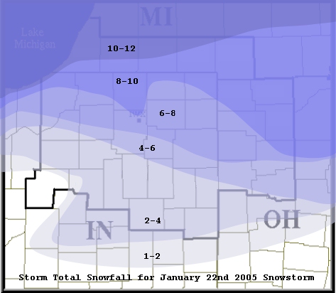 Figure 3 Contour analysis of storm total snowfall |
| Figure 4 is a water vapor satellite image on the morning of January 22nd showing the dry slot moving into western Indiana. Note the developing dry slot (red) on the nose of a 150 mph jet streak (white arrow). Snowband #1 (Figure 1) had pushed into Michigan and northwest Ohio while snowband #2 (Figure 2) was rapidly developing over northwest Indiana. |
|
Figure 4 Water Vapor Satellite Image on January 22nd at 301 am EST |
The following are some specific snow reports from around the area
LOCATION               COUNTY          SNOWFALL

...SOUTHERN MICHIGAN...

BENTON HARBOR          BERRIEN            8.1
NILES                  BERRIEN            8.9
EAU CLAIRE             BERRIEN            7.6
BARODA                 BERRIEN            7.7
SISTER LAKES           CASS              11.3
CASSOPOLIS             CASS               9.5
CENTERVILLE            ST. JOSEPH        10.0
COLDWATER              BRANCH             8.0
QUINCY                 BRANCH             8.0
GIRARD                 BRANCH             8.0
LITCHFIELD             HILLSDALE          8.1


...NORTHWESTERN OHIO...

BRYAN                  WILLIAMS           9.0
DEFIANCE               DEFIANCE           9.0
PAULDING               PAULDING           7.0
VAN WERT               VAN WERT           4.0
WAUSEON                FULTON             8.0
NAPOLEON               HENRY              9.0
DESHLER                HENRY              6.3
OTTAWA                 PUTNAM             8.0
COLUMBUS GROVE         PUTNAM             5.1
PANDORA                PUTNAM             5.0
OTTOVILLE              PUTNAM             4.5
LIMA                   ALLEN              4.0


...NORTHERN INDIANA...

ROLLING PRAIRE         LA PORTE           9.5
LA PORTE               LA PORTE           6.0
MICHIGAN CITY          LA PORTE           6.0
KINGSBURY              LA PORTE           4.5
NORTH JUDSON           STARKE             2.5
WINIMAC                PULASKI            2.0
HEADLEE                WHITE              0.5
SOUTH BEND             ST. JOSEPH         8.5
SOUTH BEND ARPT        ST. JOSEPH         8.6
PLYMOUTH               MARSHALL           7.0
ROCHESTER              FULTON             2.0
LOGANSPORT             CASS               2.7
YOUNG AMERICA          CASS               1.6
SIMONTON LAKE          ELKHART            9.5
ELKHART                ELKHART            8.5
ELKHART 1E             ELKHART            8.0
MILLERSBURG            ELKHART            6.0
SYRACUSE 4S            KOSCIUSKO          7.8
SYRACUSE - NWS         KOSCIUSKO          7.4
NORTH WEBSTER          KOSCIUSKO          7.8
WARSAW 1E              KOSCIUSKO          4.5
WABASH                 WABASH             3.0
BRIGHTON 4NE           LA GRANGE          7.0
LAOTTO                 NOBLE              7.0
KENDALLVILLE           NOBLE              6.8
COLUMBIA CITY          WHITLEY            5.0
HUNTINGTON             HUNTINGTON         3.1
GAS CITY               GRANT              3.0
MARION                 GRANT              2.5
FREMONT                STEUBEN           12.0
ANGOLA                 STEUBEN            8.0
PLEASANT LAKE          STEUBEN            6.0
AUBURN                 DE KALB            7.0
FT. WAYNE ARPT         ALLEN              5.5
HOAGLAND               ALLEN              4.0
MONROEVILLE            ALLEN              3.8
BLUFFTON               WELLS              3.0
HARTFORD CITY          BLACKFORD          1.7
MONROE                 ADAMS              4.0
PORTLAND               JAY                2.0

THE NATIONAL WEATHER SERVICE IN NORTHERN INDIANA THANKS OUR
VOLUNTEER SNOW SPOTTERS FOR THEIR REPORTS. WE ENCOURAGE YOU TO
REPORT YOUR SNOWFALL THROUGHOUT THE WINTER SEASON.

$$
TEH/LWF...01/23/05