Severe Storms on April 9th, 2001
A stalled frontal boundary extended from northern Ohio back west into northeast Missouri with a developing low pressure wave near Quincy, Illinois Monday afternoon. This wave intensified late in the afternoon as a shortwave trough embedded within the southern periphery of a significant upper jet maxima of 120 knots over Minnesota pulled out into the upper Midwest. Wind profilers at both Wolcott Indiana and Winchester Illinois indicated rapid backing low level winds and increasing speed convergence around 2500 feet coincident with rapid convective initiation along the frontal boundary from Logansport to Rensselaer.
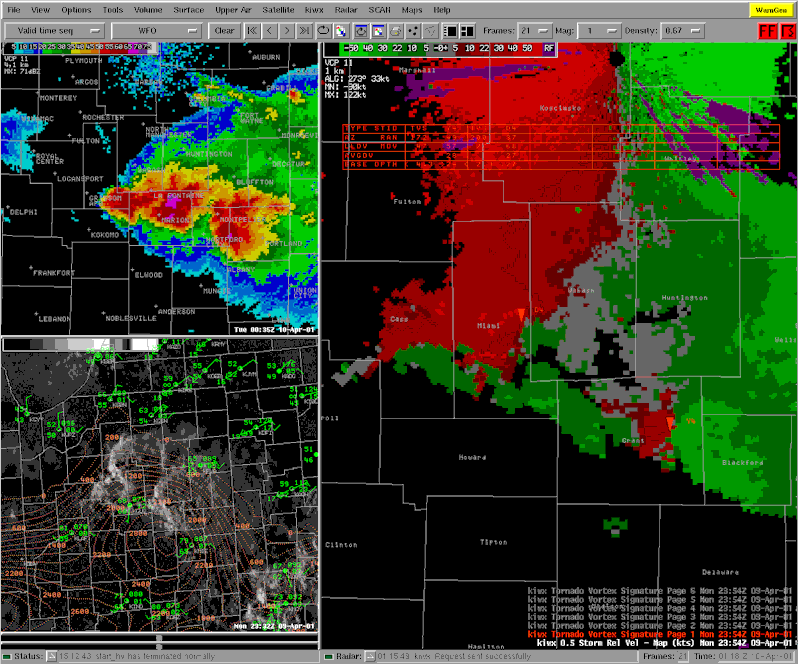
Storms rapidly intensified with capes (convective available potential energy, a measure of parcel buoyancy) south of the frontal boundary up to 3000 J/kg. In addition...several storm scale mergers were observed with a left over outflow boundary from prior convection. Thunderstorm intensification was very rapid owing to the large amount of instability in place along and south of a Monticello to Muncie line. Deep layer shear of 50 knots was more than sufficient for supercell development. Indeed most storms along the outflow boundary exhibited strong rotation...mainly at mid-levels but two storms in particular that moved across Cass, Miami, Grant, Blackford and Jay exhibited several tornado vortex signatures, Fig. 1 - inverted red triangles, that were persistent and quite deep. In addition...bounded weak echo region, (BWER) was associated with the supercell storm that moved through Miami, Grant and Blackford counties and is often seen with tornadic storms. Note the upside down V shape, Fig. 2 - left. In addition, grid based vertically integrated liquid, (VIL), did indicate very large hail with this storm which was indeed correct as the storm dropped 4.5 inch diameter hail just north of Hartford City. However...during post event analysis...it appears surface winds from 230-250 degrees at 15 knots did not provide enough low-level shear to get the tornadic circulation aloft down to the ground even though storm motions were highly right deviant. The following reports of large hail and funnel/wall clouds were received:
 |
|
Fig. 1 - Awips 3-panel display showing composite reflectivity (top left), CAPE/VIS satellite (bottom left), and 0.5° Storm Relative Motion/Tornado Vortex Signature(right)
|
 |
| Fig. 2 - Awips 2D cross-section (left) and grid based VIL (right) |
This story written by TH

