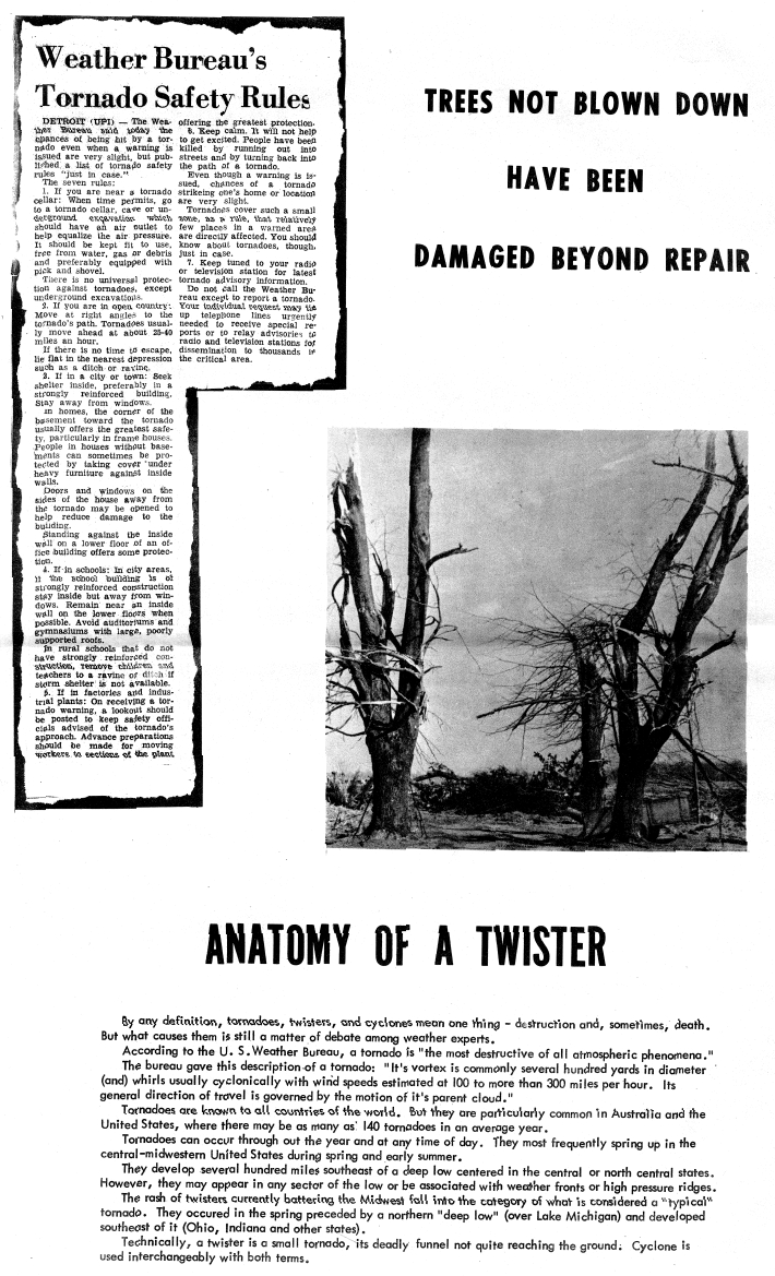
The Palm Sunday Tornado outbreak occurred on April 11-12, 1965, across the states of Illinois, Indiana, Iowa, Ohio, Michigan and Wisconsin. 47 Tornadoes (15 significant, 17 violent, and 21 killers), wrecked havoc upon the land. It is the third deadliest tornado outbreak on record with 261 deaths, trailing the Super Outbreak which killed 315, and the March 18, 1925 outbreak which spawned the infamous Tri-State Tornado which killed 747.
The April 11-12th 1965 Tornado outbreak across the upper Midwest and Great Lakes marked a watershed moment in weather history. Due to the tragic loss of life and catastrophic damage that was observed in a following National Weather Service Storm Survey, a list of recommendations was formulated and eventually instituted. Many of these were ground breaking and well ahead of there time yet easily adapted based on the emergence of the telecommunications and computing age.
| F0 | F1 | F2 | F3 | F4 | F5 | Total |
|---|---|---|---|---|---|---|
| 0 | 15 | 10 | 5 | 17 | 0 | 47 |
| List of reported tornadoes - Sunday, April 11, 1965 | ||||||
|---|---|---|---|---|---|---|
| F# | Location | County | Time (UTC) | Path length | Damage | |
| Iowa | ||||||
| F4 | NE of Tipton | Cedar, Clinton, Jackson | 1855 | 91.5 miles (147.3 km) | 1 death - One person died one month later from their injuries. 25 farms were affected, one of which had every building leveled. Pieces of a farm house were carried for over a mile. | |
| F1 | SE of New Hampton | Chickasaw, Fayette, Allamakee | 1915 | 49.9 miles (80.3 km) | ||
| Wisconsin | ||||||
| F1 | SE of Monroe | Green, Rock, Dane | 2000 | 27.1 miles (43.6 km) | 50 homes and 65 businesses destroyed or damaged and 40 were injured. Over 400 cars were damaged or destroyed. | |
| F2 | S of Watertown | Jefferson | 2030 | 14.5 miles (23.3 km) | 3 deaths - Deaths were from occupants of a car that was thrown. 28 others were injured. Structures were destroyed on 20 farms. | |
| F1 | S of Soldiers Grove | Crawford | 2045 | 13.3 miles (21.4 km) | One barn was destroyed. | |
| F1 | W of Lake Geneva | Walworth | 2150 | 1.9 miles (3.1 km) | Homes and structures were damaged near Williams Bay. | |
| F1 | NW of Elkhorn | Walworth | 2155 | 1 mile (1.6 km) | One barn was destroyed. | |
| F1 | W of Tomah | Monroe | 2214 | 2 miles (3.2 km) | Several farm buildings were destroyed. | |
| Illinois | ||||||
| F4 | Crystal Lake | McHenry, Lake | 2120 | 9.1 miles (14.6 km) | 6 deaths - Destroyed large sections of the town including a shopping mall. 45 homes were destroyed and 110 were damaged in a single subdivision. A few of the homes were completely swept away. Damage estimates were at about $1.5 million. | |
| F2 | N of Gurnee | Lake | 2150 | 4.5 miles (7.2 km) | Several homes were damaged and two planes flipped at Waukegan Memorial Airport. Falling trees damaged some homes and two others lost their roofs. | |
| F1 | Geneva | Kane | 2200 | 0.3 miles (0.5 km) | About a dozen homes were heavily damaged | |
| F1 | Zion | Lake | 2204 | 0.5 miles (0.8 km) | ||
| Indiana | ||||||
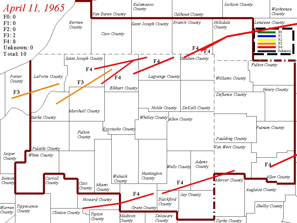
| F3 | NE of Knox to S of South Bend | Starke, Marshall, St. Joseph, Elkhart | 2245 | 35.6 miles (57.3 km) | 10 deaths - 30 cottages were destroyed and 70 others were damaged along Koontz Lake. 26 homes, one church and one high school were also destroyed. There were 82 people injured. Severe damage took place near La Paz and in the town of Wyatt. | |
| F3 | S of Crown Point to SE of Laporte | Porter, Laporte | 2310 | 33.1 miles (53.3 km) | Several homes and barns were destroyed and 4 people were injured. | |
| F4 | W of Wakarusa to NW of Middlebury | Elkhart | 2315 | 21.2 miles (34.1 km) | 14 deaths - Tornado first touched down and caused severe damage in the Wakarusa area. Destroyed the Midway Trailer Park in Dunlap and numerous other homes in the Middlebury area. Some homes were completely swept away. Was photographed as a double tornado. A Goshen airplane wing was found 35 miles away in Centerville, Michigan. 1st of 2 tornadoes to hit the town of Dunlap. May have been an F5. | |
| F4 | NE of Goshen to W of Orland | Elkhart, LaGrange | 2340 | 21.6 miles (34.8 km) | 5 deaths - Dozens of homes were demolished in the Rainbow Lake and Shore areas south of Shipshewana, several of which were completely swept away. Some sources list 17 fatalities. May have been an F5. | |
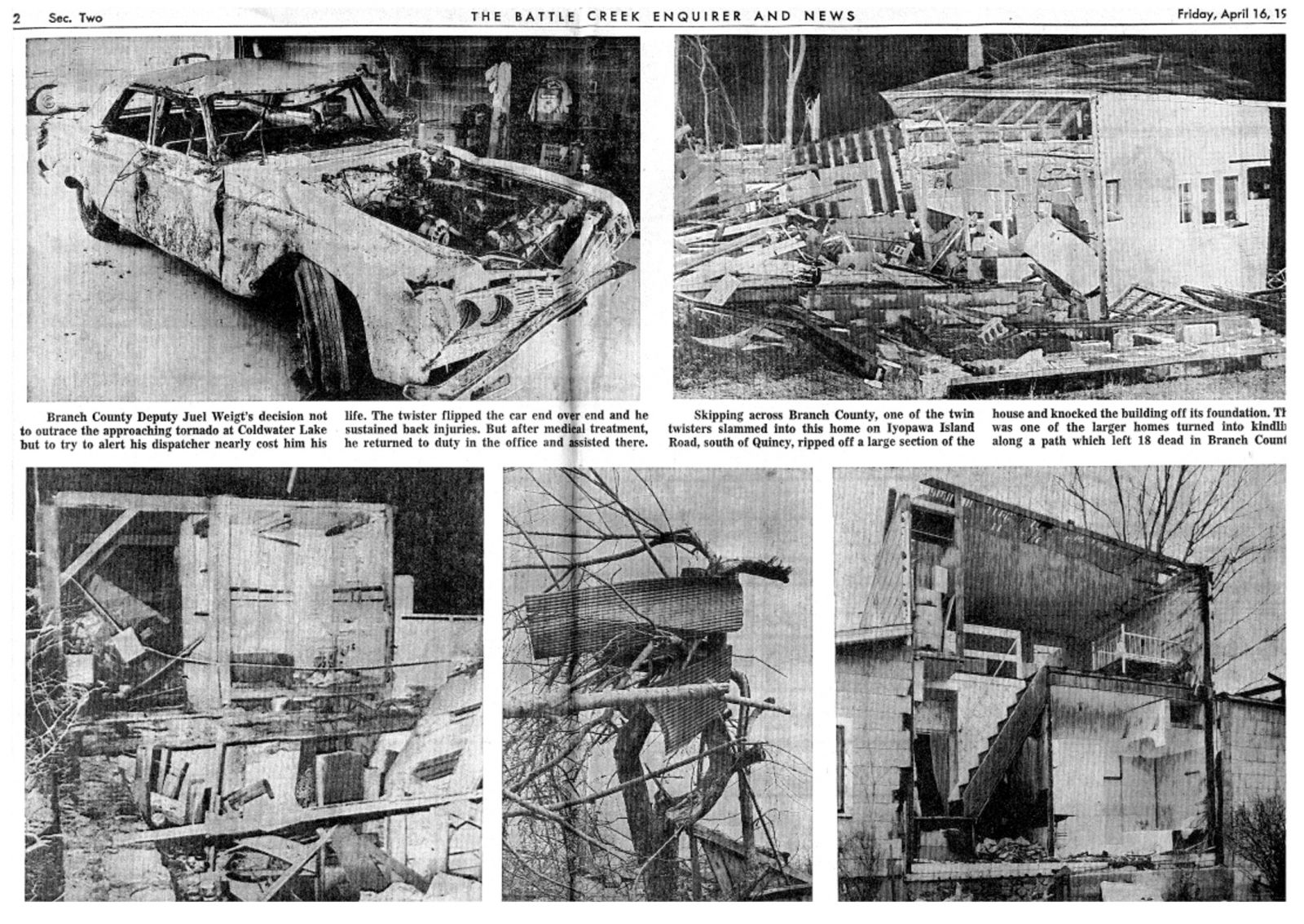
| F4 | Manitou Beach-Devils Lake, Michigan (1st tornado) | Steuben, Branch, Hillsdale, Lenawee, Monroe, Washtenaw | 0000 | 90.3 miles (145.3 km) | 23 deaths - Starting just south of the Indiana-Michigan state line, this massive tornado caused extensive damage to the Manitou Beach region and areas southwest of Detroit. Many structures were destroyed, including a row of homes that were completely swept away and thrown into Coldwater Lake. First of two violent tornadoes to affect the same portion of Lower Michigan. Damage from the two tornadoes was difficult to separate. Damage path in Lenawee county extended up to 4 miles wide. | |
| F4 | SE of Lafayette to W of Russiaville | Tippecanoe, Clinton | 0007 | 21.8 miles (35.1 km) | Several homes and other buildings were destroyed or damaged. Homes were completely leveled in Mulberry and Moran. | |
| F4 | SE of South Bend to NE of Shipshewana | St. Joseph, Elkhart, LaGrange | 0010 | 37 miles (59.5 km) | 36 deaths - 2nd violent tornado to strike the town of Dunlap in just over an hour. The Sunnyside subdivision was completely destroyed, with many homes swept away. The Kingston Heights subdivision was also devastated. 6 of the victims were killed when the tornado demolished a truck stop. Affected rescue efforts after the first tornado. Also was witnessed as a double tornado. Was initially rated an F5 but downgraded to an F4. | |
| F4 | Russiaville to SE of Marion and Greentown | Clinton, Howard, Grant | 0020 | 48 miles (77.2 km) | 25 deaths - Large sections of Russiaville, Greentown, southern Kokomo and Alto were destroyed. 90% of the structures in Russiaville were damaged or destroyed. The tornado was up to a mile wide when it struck Alto and Kokomo, where hundreds of homes were destroyed. Many homes were destroyed and swept away as the tornado struck Greentown, and multiple fatalities occurred in vehicles in that area. A hospital had its roof torn off south of Marion, and a shopping center was destroyed. Several homes were destroyed in Marion as well. Over 800 people were injured. | |
| F4 | SE of Crawfordsville to Arcadia | Montgomery, Boone, Hamilton | 0050 | 45.7 miles (73.5 km) | 28 deaths - 80 homes were destroyed and over 100 people were injured between Crawfordsville and Arcadia. Some of the most severe damage occurred near the towns of Lebanon and Sheridan. Tornado was up to a mile wide and threw cars over 100 yards. May have been an F5. | |
| F4 | W of Montpellier to N of Spencerville, OH | Blackford, Wells, Adams, Mercer, Van Wert | 0110 | 52.5 miles (84.5 km) | 4 deaths - F4 damage was observed in Keystone in Wells County. Severe damage also occurred in the Berne area, where a bowling alley, a lumber yard, and a grocery store were destroyed. Tornado crossed into Ohio where it destroyed five homes and damaged five others. | |
| Michigan | ||||||
| F4 | N of Grand Rapids | Ottawa, Kent | 2254 | 20.6 miles (33.2 km) | 5 deaths - 34 homes were destroyed and nearly 200 others damaged near the northern suburbs of Comstock Park and Alpine. Nearly 150 were injured and damage amounts were estimated at almost $15 million. | |
| F1 | N of Middleville | Allegan, Barry | 0005 | 19.5 miles (31.4 km) | 1 death - A trailer and 5 homes were destroyed while 25 others were damaged. | |
| F3 | NE of Kalamazoo | Kalamazoo | 0030 | 14.2 miles (22.9 km) | 4 homes were destroyed and 22 others damaged. 17 people were injured. | |
| F3 | Hastings | Barry | 0040 | 14.1 miles (22.7 km) | 15 homes were damaged and barns and garages were leveled. | |
| F4 | Manitou Beach-Devils Lake, Michigan (2nd tornado) | Branch, Hillsdale, Lenawee, Monroe, Washtenaw | 0040 | 80.5 miles (129.6 km) | 21 deaths - Second tornado to hit the same areas 30 minutes after being affected by the first tornado. Tornado leveled what was left standing from the first tornado. Total damage estimates from the two tornadoes were $32 million. Over 550 homes, 2 churches, a dance hall, and 100 cottages were destroyed in total. The two tornadoes also caused major damage in and around the towns of Onsted and Milan. | |
| F4 | N of Lansing | Clinton, Shiawassee | 0115 | 21 miles (33.8 km) | 1 death - Several homes were severely damaged or destroyed, one of which was swept away. | |
| F2 | W of Ithaca | Montcalm, Gratiot | 0125 | 15.1 miles (24.3 km) | Several farm buildings and livestocks were destroyed. One home was nearly leveled. | |
| F2 | Alma (1st tornado) | Gratiot | 0130 | 0.1 miles (0.16 km) | One of three tornadoes to strike the area where it caused damage to several buildings including the library, which had its roof torn off. A telephone repair facility was destroyed as well. | |
| F2 | Alma (2nd tornado) | Gratiot | 0130 | 0.5 miles (0.8 km) | ||
| F2 | E of Alma | Gratiot | 0130 | 1 mile (1.6 km) | ||
| F2 | SE of Bay City | Bay | 0150 | 9.9 miles (15.9 km) | Tornado tore the roof off homes and an auto dealership. Trailers and barns were destroyed as well. | |
| F2 | SW of Unionville | Tuscola | 0200 | 9 miles (14.5 km) | Damage to a firehall and lumberyard. Barns were also destroyed. | |
| Ohio | ||||||
| F4 | Northern Toledo | Lucas, Monroe | 0230 | 5.6 miles (9.0 km) | 18 deaths - Numerous homes in the northern suburbs of Toledo were completely destroyed, several of which were completely swept away. 5 people were killed when the tornado picked up a bus and slammed it upside down onto the pavement. Boats and cars were thrown onto and into buildings. A paint factory and department store were destroyed as well. Two people were killed on the Lost Peninsula in Michigan. There were reports of twin tornadoes during the event. Damage amounts were estimated at $25 million. | |
| F4 | N of Lima | Allen, Hancock | 0230 | 32.5 miles (52.3 km) | 13 deaths - Numerous homes and farms were destroyed along the track, some of which were completely obliterated. | |
| F4 | N of Sidney | Shelby | 0300 | 18.4 miles (29.6 km) | 3 deaths - Affected Anna, Swanders and Maplewood where 25 homes were destroyed and 20 others heavily damaged. Several train cars were derailed, and an automobile was carried for 200 yards. | |
| F3 | SE of Tiffin | Seneca | 0315 | 15 miles (24.1 km) | 4 deaths - Struck Rockaway, where 4 homes were leveled and three others were damaged. | |
| F4 | S of Oberlin to Strongsville | Lorain, Cuyahoga | 0405 | 22 miles (35.4 km) | 18 deaths - Extensive damage to Pittsfield and Strongsville. Pittsfield was nearly entirely destroyed and 6 homes were completely swept away there. Vehicles were thrown hundreds of feet and mangled. The tornado then struck Grafton at F2 strength, damaging homes and a car dealership before re-intensifying and striking the north side of Strongsville. In Strongsville 18 homes were leveled, some of which were cleanly swept from their foundations. 50 others were badly damaged in town. Damage amounts were estimated at $5 million. Was listed as an F5 according to meteorologist and tornado historian Thomas Grazulis. Also witnessed as a double tornado. | |
| F1 | S of Eaton | Preble | 0415 | 0.1 miles (0.16 km) | ||
| F1 | Brunswick | Medina | 0430 | 8.2 miles (13.2 km) | One home was destroyed and several others were damaged in Brunswick. | |
| F2 | N of Delaware | Union, Delaware, Morrow | 0430 | 22.2 miles (35.7 km) | 4 deaths - Tornado struck the towns of Radnor and Westfield. 4 were killed in Radnor and 22 were injured in Westfield. 25 homes were destroyed. | |
| F1 | S of Cedarville | Greene | 0450 | 0.1 miles (0.16 km) | ||
| F1 | Ashville to Somerset | Pickaway, Fairfield,Perry | 0530 | 38.4 miles (61.8 km) | Several farm buildings were destroyed along the path. A dozen trailers were destroyed at a sales lot in Dumontville. | |
| Sources:
Tornado History Project Tornado Data for April 11, 1965, Tornado History Project Tornado Data for April 12, 1965, NCDC 22508 NWS Detroit Storm Data |
||||||
| List of reported tornadoes - Monday, April 12, 1965 | ||||||
|---|---|---|---|---|---|---|
|
|
|
|
|
|
|
|
| Georgia | ||||||
| F1 | SW of Grassdale | Bartow | 0950 | 2 miles (3.2 km) | ||
| West Virginia | ||||||
| F2 | N ofPrinceton | Mercer | 1130 | 0.1 miles (0.16 km) | ||
| Sources: | ||||||
A special thanks goes to the following: Blake Naftel for providing digitized photos and excerpts from this event, Jon Chamberlain for constructing and providing reanalysis weather maps of the event, construction of the Google kml file and excerpts from his ongoing research paper, Larry Camp (WB8R) for providing damage pictures and newspaper clippings from Branch county, Becky Monroe for her damage pictures from Marion, Ed Lacey Jr. for providing damage pictures from Grant county, Dick Loney for providing damage pictures from Elkhart county, Kevin Barker for providing damage pictures from the Coldwater Lake area in Branch county, Elkhart Truth, Goshen News, Mishawaka Times, Kokomo Morning Times, South Bend Tribune, Indianapolis Star, Cold Water Daily Reporter, Quincy Herald and Battle Creek Enquirer.
Tetsuya T. Fujita, Dorothy L. Bradbury, and C. F. Van Thullenar, 1970: Palm sunday tornadoes of april 11,1965. Mon. Wea. Rev., 98, 29-69.
Edwin J. Adlerman and Kelvin K. Droegemeier, 2005: The dependence of numerically simulated cyclic mesocyclogenesis upon environmental vertical wind shear. Mon. Wea. Rev., 133, 3595-3623.
Matthew J. Bunkers, Jeffrey S. Johnson, Lee J. Czepyha, Jason M. Grzywacz, Brian A. Klimowski, and Mark R. Hjelmfelt, 2006: An observational examination of long-lived supercells. part ii: environmental conditions and forecasting. Wea. Forecasting, 21, 689-714.
Stephen F. Corfidi, Steven J. Weiss, John S. Kain, Sarah J. Corfidi, Robert M. Rabin, and Jason J. Levit, 2010: Revisiting the 3-4 april 1974 super outbreak of tornadoes. Wea. Forecasting, 25, 465-510.
Maddox, R. A., M. S. Gilmore, C. A. Doswell, R. H. Johns, C. A. Crisp, D. W. Burgess, J. A. Hart, and S. F. Piltz, 2013: Meteorological analysis of the Tri-State tornado event of March 1925. Electronic J. Severe Storms Meteor., 8(1), 1-27.
Grazulis TP. 1993. Significant Tornadoes, 1680-1991. Environmental Films: St. Johnsbury, Vermont, Canada.
Peter C. Banacos and Michael L. Ekster, 2010: The association of the elevated mixed layer with significant severe weather events in the northeastern united states*. Wea. Forecasting, 25, 1082-1102.
E. M. Agee, J. T. Snow, and P. R. Clare, 1976: Multiple vortex features in the tornado cyclone and the occurrence of tornado families. Mon. Wea. Rev., 104, 552-563.
Joshua Wurman and Karen Kosiba, 2013: Finescale Radar Observations of Tornado and Mesocyclone Structures. Wea. Forecasting, 28, 115-1174.
The day was going to be busy, it was apparent right from the start. A strong springtime storm system was developing over the Central Plains, and all the ingredients for severe weather were present. Warm, very moist air was flowing northward from the Gulf of America with cool air rushing down from Canada to meet it. A jet stream streaked across the country from southern California to northern New England, passing right over the developing surface system.
Analysis of the 7 am surface chart showed a large red "L" drawn just about on the center of the map. Low pressure was deepening over western Iowa. From this low center a warm front reached east across central Illinois to central Indiana, and then snaked its way to South Carolina. In the other direction, a cold front dropped south to the Ozarks and then southwestward to the Big Bend region of Texas.
At 1045am, the Severe Local Storms Unit, SELS, in Kansas City issued a statement concerning the possibility of tornadoes that afternoon from northeast Missouri across central Illinois to north central Indiana.
Around 1pm, the SELS forecaster issued a tornado forecast (analogous to today's tornado watch). It covered central and northern Illinois and southernmost Wisconsin. Unbeknownst to him, the first two tornadoes of the day had touched down fifteen minutes earlier.
The cumulus had risen into thunderheads by the dinner hour, and at 12:45pm a funnel snaked its way out of one of those clouds, and hit the ground near the community of Tipton in Cedar County Iowa. It quickly grew and produced F4 damage to two dozen farms. A man near Lowden was battered by the swirling debris as he ran for his storm cellar. He died the next month.
Though it was apparent to most meteorologists that the weather on that eleventh day of April was going to be much more dangerous than usual, nobody imagined that the Lowden tornado would be the first of thirty-nine twisters to tear up the Midwestern landscape over the course of the afternoon and evening. Nobody dreamt that those tornadoes would carry death to 260 people.
At 2pm, the storm experts at SELS noticed that the jet stream was splitting into two branches, like a river flowing around an island. That island was located above and along the Illinois/Wisconsin border.
Personal Stories
John Curran: I was a GS-5 Observer/Briefer at the Fort Wayne Weather Bureau Airport Station on April 11, 1965, at the time of the infamous Palm Sunday tornado outbreak. I worked the day shift, 8 AM to 4 PM. Friends and I had attended Saturday night a dance in one of the northwest Ohio towns that regularly held public dances. I had gotten much less than a full night's sleep. When my relief showed up just before 4 Pm I was urged to go home as I was due back in at midnight for a quick turnaround. At the end of my shift no severe weather was in the Ft. Wayne County warning Area. The severe weather was still a distance to the west, as I recall.
I went home and crashed into bed. My roommate came back around d 10:30 PM woke me up and exclaimed, "John, what the hell is going on?" "What do you mean, what is going on, I've been asleep!" He said, "All the TV stations are off the air most places are without power." I turned on the radio and found one local station with a very weak signal operating on emergency power. Fort Wayne's power was provided by two utility companies. City Power and Light generated their electricity locallyâ?¦those customers did not lose power. The other utility, Indiana and Michigan, lost their high voltage transmission lines due to the tornadoes. At the time it was said there were 13 high voltage transmission lines that were the source for I & M's Fort Wayne customers, but they had all been severed. I don't know if that number is correct, but none of the I & M customers in Ft. Wayne had power. It was a crazy quilt patternâ?¦some neighborhoods had power, some didn'tâ?¦even houses within the same block may or may not have dad powerâ?¦depending on which utility served the house. It created a very bad public relations period for the I & M customers, and there was pressure to convert the whole city to City power and light as it took months for the city to fully recover its power. I digress.
When I got to the office for the midnight shift, I found the electronics technician Arnie Koch had strung an extension cord down the hall from the FAA Flight Service Station, which had power. There were no lights in the officeâ?¦the only lights were from a couple of teletype machine that Arnie had powered up. Somehow I got through the night improvising as I went along to transmit the observations. I don't remember if the office had an emergency generator, if it did, it didn't work, or was woefully underpowered. As I got off work, there was a general appeal being made for blood donations. I went to the donation center on my way home, but was told I could not donate, due to my lack of sleep.
The following day, Tuesday, April 13, 1965, I had a scheduled day off, but accompanied the office's Meteorologist in Charge, Clyde Downs, and his wife on a day long storm survey. We drove to the southern part of the county warning area and picked the storm track in southern Grant County. The Palm Sunday tornadoes were long tracked tornadoes and this track had originated to the west of Russiaville. Memories that stand out are a mobile home court in the south part of Marion. The mobile homes looked like they had been tossed into a child's playboxâ?¦lying every which way, splintered beyond recognition, some on top of one another, some upside down and some with only the steel frame remaining. Horrible. For the rest of my Weather Service career I worried about people living in mobile homes in the path of a tornado.
From south Marion and Gas city we followed the path east northeast through the farmland and small communities. We interviewed farmers and town residents, asking about the time of occurrence and what they saw and did. One young man told me he was trying to outrace the tornado, I believe he may have been on highway 18 east of Marion. He saw debris, like small stones passing him from behind; he looked at his speedometer and it was 90 mph! He realized he was not going to outrun the tornado and made a wise decision to turn to the right or to the south and thus lived to tell the tale. While the forward movement of the deadly Palm Sunday tornadoes was approaching 60 mph, it is my belief that the debris the young man saw was being ejected from the tornado at the speed of the rotating tornadic winds, like shot from a cannonâ?¦at speeds of 200 mph or more.
It was in Bern, Indiana that the Palm Sunday tornado made the most impressionable memory. We approached the town from the south on Highway 27. It was here that the immensity of the storm was most visible, as in rural areas the width is not easily marked. The damage kept getting more and more severe as we drove north. The memory, well actually, two memories were seared into my mind. On the west side of Highway 27 there was a stretch of three or four homes that were totally destroyedâ?¦the only thing left was the concrete slab, with perhaps a bathtub or toilet bolted to the floor. But, most remarkable for me, was there was no debrisâ?¦the storm had made a clean sweep! I always remembered this and often commented in spotter talks that if you are going to be hit by and EF4, pray it is an EF5 and you won't have the cleanup costs. The second memory about Berne was how the Amish community pulled together. Here it was Tuesday afternoon, less than 48 hours after the Palm Sunday outbreak, and Amish carpenters were already busy reframing the homes that had been badly damaged. I've since learned, "That's what they do!" They drop everything and help their neighbors. I saw enough tornado damage this day to last me a lifetime. I had seen damage before growing up in Nebraska, but never on the scale of EF5s, a half mile wide or more, racing through the countryside at speeds up to 60 mph. The old WSR-3 radar displayed a prominent hook as the tornado approached Berne, IN. Clyde Downs, the Meteorologist in Charge, immediately issued a tornado warning for Berne based on the radar echo, but I believe the tornado had already crossed into Ohio by the time the warning was transmitted on the Weatherwire. In addition, the receipt of a phone call of a tornado in Marion resulted in a tornado warning being issued for a tornado that had passed through an hour earlier.
The personnel at the FT. Wayne Weather Bureau Office did as well as well as could be expected with its warnings with the tools provided at the time. There were some serious lapses and it may be seen as bordering on incompetence. But one has to remember that the radar at the time was the WSR-3, built in WWII for the purpose of detecting aircraft. The small scope had a rapid decay rate with no map background, which made for a time consuming process of outlining the echoes on onion skin paper. The storm intensity displayed was purely a relative analog display. In short, the radar was primitive, with poor resolution and low powered. The Weather Wire, which fed forecasts, warnings, etc, to the news media, operated at 60 wpm, or was it 75? Input to the Weather Wire was either raw through a keyboard, or through five level Baudot paper tape, which had to be cut "in the blind." The Warning Preparedness program that we have today was nearly nonexistent. The trained spotter network was primitive, mostly nonexistent.
The Palm Sunday tornado outbreak is an example of how good can come from something bad. The Weather Bureau, now the National Weather Service, has, with strong taxpayer support, done a magnificent job of upgrading the entire warning process, from equipment, to manpower, to training and strengthening relationships with the media, law enforcement, and the general public.
John Curran
Retired Meteorologist in Charge,
Indianapolis National Weather Service
Ron Przybylinski: I experienced this terrible severe weather event day in the South Bend Indiana area. I was age 11 and remembered this day quite well. My family went to Palm Sunday services that morning. I remembered scattered showers and thunderstorms that morning after church services. Surface winds were from the south and southwest approximately 15 to 25 mph maybe with gusts as high as 30 mph. After the storms - full sunshine and windy conditions continued.
That afternoon after dinner we visited a famous ice cream restaurant called "Bonnie Doones" then we went home. We then watched television and at that time the local television stations were show in bold letters "Tornado Watch" or Tornado Warning." No radar data shown at that time on TV. Basic white background with black large letters.
I remembered this first of three lines of scattered convective storms. It was scattered storms and not a continuous line of storms. I believe a few of these storms - at that time we never heard of the word supercells. But a few of these storms were producing tornadoes. What was really interesting is that the skies were clear blue after the passage of each of the three convective line. Not much in the way of cirrus anvils. The 4th line of storms were nearly a solid line of supercells. I believe I observed about 8 to 10 of them as the line passed. We were watching the show "Lassie" on the local CBS station. I know a few of you may not know this show. Just as the fourth line of supercellls passed we experienced "golf ball size hail." at our home and went down to the basement. We were lucky that we just experienced hail damage. My family's house was located on the southwest side of South Bend. Just before we hit the basement we heard of a tornado at Koontz Lake Indiana (far northwest Marshall county Indiana). And then on the local CBS station the local NWS weather office stated that in words - "there were so many tornado reports that it was hard to keep track of them." We went down the basement after this.
Once the line of supercells passed on through we heard of the damage to farmsteads - and damage in Lapaz and Wyatt Indiana in southeast St. Joseph County Indiana then we heard of damage to a nursing home in Elkhart County Indiana where I believe there were several fatalities. I remembered the local CBS station (Channel 22) was showing taped video of the damage and interviewing folks who were affected by the destructive tornadoes.
The following weekend my Dad and Mom took us down to Koontz Lake Indiana and we observed approximate 150 yard wide of trees completely snapped and uprooted east of Indiana highway 23. There was also damage to a number of structures in the town of Koontz Lake as well. What was interesting is that someone reported a funnel cloud the following Sunday when my parents took us down to observe the damage. We left immediately. One addition, I remembered that President Johnson maybe a week later toured the damage area south of South Bend and over in Elkhart county Indiana.
This major severe weather event sparked my interest in meteorology from this time on. I have a picture of the twin tornadoes near U.S Highway 33 by Paul Huffman from the Elkhart Truth took south of the twin tornadoes. This was given to me by a friend over 20 years ago where this person knew Paul.
Just wanted to share with everyone my experiences on this day which I will always remember.
Ron Przybylinski
NWS St. Louis SOO - 04/11/2014
Sharon Barhydt: My husband was a kid in Goshen watching this happen. He told me how they could see the mobile homes going up in the air and exploding at a park that I believe he said was Midway Mobile Home Park.
Robert Owen: This took the chicken coop off of the foundation on the farm house I grew up in and my mother was pregnant with me and has told me amazing stories about the destruction the day this happened and her and dad lived through and drove through the devastaion and dad helped clear roads and check to see if people survived. Pretty wild.
Linda Kay Klinedinst: Me and my younger brother was standing on our front porch along with our parents and it got really black out. After the Tornado went through Koontz Lake and tore all of the houses up, my Parents, my younger brother and I went for a drive through Koontz Lake to see all of the damage from the Tornado. A Police Officer asked my Dad if he had a Flash Light because he loaned a driver his flashlight. My Dad gave this Police officer a Flashlight and he thank my Dad. I can still see the damage that the Tornado did to Koontz Lake to this day. I will never going to forget it. I wish I had pictures but I don't.
Julie Gaspar: My mom was pregnant for my brother I was 2. I remember my dad carrying me and running while big hail balls where everywhere. My great Uncle was a volunteer for concord fire department.
Wanda Sue Cole Landrum: My Dad took us to see the Devastation at K Koontz Lake..houses sitting in the middle of the lake, ripped apart in two..it looked like a doll house-- you could see every room, every floor.
Cris Dunlap Ramsey: Two sets of great grandparents who lived around the country corner from each other near Cairo, Ohio were significantly affected. One set got into the basement just in time but lost everything. Someone near Cleveland found their wedding postcard and mailed it back to them somehow.The other set died (grandma that day, rolled in the corn stubble and grandpa died about 6 days later). They had just had a wedding anniversary party and their kids had left not long before the storm. Grandpa had just gotten out of the hospital sometime that week before the storm.
Kathy Selzer Miller: I was in Fort Wayne when the tornadoes were going on. We were watching the Ed Sullivan Show with the Herman's Hermits performing and the tv signal was lost and then the power went out for 3 days. But because Fort Wayne had their own City Utilities at that time, the schools still had power. We went to school Monday and Tuesday and came home to houses with no power since that was provided by I&M. Fort Wayne long ago sold City Utilities to I&M and if this ever happened again all the city would be without power. No destruction in Fort Wayne, but I know there was damage south of Fort Wayne.
Larry Haag: I remember devastation like I've never seen before. Riding around with parents and seeing our friends house totally blown away from the ground up. It was like a bomb had went off.
Jim Beck: We got chased on Kern Rd coming from South Bend, Dad couldn't go any faster so we pulled into a house and i remember Dad running in the front door. We all made the basement with seconds to spare. Dad used to own 1 of the mobile home parks around Goshen and was afraid it was ours that was destroyed. Dad went to Goshen on a farm tractor to get around downed trees , we slept in the basement. I hate tornadoes to this day !
Scott Taylor: My dad and mom lived in house just west of Hillsdale said very warm day and storm moved in late afternoon got pretty scary wind, dark, hail, lots of lightning. Dad was taking my sister after first storm to her moms near pittsford. On way back to hillsdale was near Osseo, Mi second storn moved in. Had to pull over because 75+ mph winds rocking his car and told me lighting bolts hitting ground so intense hurt his eyes put sun glasses on. This was when we estimated f4 about 2-3 miles north of his location. He was just a few miles se of Baw Beese Lake as F4 tore houses apart. Learned also 2 major tornado followed each from one end of hillsdale county to the other ne section of county. One tornado just before it was about to enter the city of Hillsdale made a slight right turn and just missed city ended up hitting Baw Beese Lake and summer cottage. These sane tornadoes decimated Devils Lake, Michigan and in a movie, book called Night of the Twisters. Clip on you tube. I have since bought a small cottage near devils lake which survived but business just east of house destroyed (possible satillite tornado) and church just west of my house destroyed. A picture in night of the twisters can see my house with all windows broke out and all the trees around it uprooted. As well as a car in same photo wrapped around tree base (two teenage boys tragically died in this car).
LuAnn Mouton: I was only 6 years old then, and I remember standing in our yard with my stepdad watching the tornado across the field from us, and my mom was in the basement yelling at us to come inside!
Sandra Emerick: I was only 2yrs old when Palm Sunday hit. I don't remember anything. But my late father during that time worked for General Telephone, he went to help those in need. He helped with rescue efforts. My late mother helped with the Red cross. She served water and food to those in need.
Victoria Dynes-Beer: I was 5 and we lived in Geneva IN south of Berne IN. We were coming home from church in my grandfather's Chevy Impala convertible. We were listening to WOWO when the warning sounded. We were watching the sky and saw the twister coming us at. Grandpa stopped at the Trees Drive In (root beer stand) as we had nowhere else to go. I remember the car rocking in the wind. We were fortunate that the tornado stayed north of us but the devastation afterward was immense. Whole factories gone. I get very anxious when I hear the sirens or the watches and warnings issued.
Lynn Stair-Harshaw: I remember being wrapped up in a blanket like a burrito, mom watching out the door from our mobile home, we lived near Van Buren at my grandmas property. Mom said if we didn't have time to make it up to grandmas basement we'd dive into the ditch and she wanted me covered up...we could see it from a distance. Then we went to my other grandparents farm on 400E just outside of Marion. Driving up the lane we could see there was a 2x4 sticking out of a huge rock on their property and several farm equipment machines turned upside down like toys, windmill twisted and bent in half and the barn was missing three sides and the roof, dad mentioned at the time he couldn't figure out how it had left 1 wall standing. The house wasn't damaged but all the other buildings were...still amazing looking at pictures and the damage that occurred on that day.
Darlene Rowe Howard: That looks like the twin tornadoes that ran down highway 20, next day my husband and I drove there and the tornadoes wiped out several chicken farms. There were feathers for miles. There were houses hit near Wolcottville with one wall gone and stuff in the rooms looking like they were never touched. I still don't like storms to this day.
Bruce Hamrick: I was 7 years old and lived near Chattanooga, Ohio. My grandparents from Mendon were visiting. We were watching Ed Sullivan and we lost the signal on TV. Then we got a grainy signal and the announcer on Channel 15 told us there were tornadoes in Elkhart and other areas and moving east. My Grandparents decided to head home. My parents and us 3 kids then went 1/4 mile down the road to my other grandparents home because they had a basement. My Dad and Grandpa stood out in the yard keeping watch. My Mom and Grandma told us to stay in the bedroom and be ready to go to the basement. They listened on the radio. The multiple tornadoes skipped over us after devastating Linn Grove and the Berne Ind Area. The next day we drove around the Indiana and Ohio State Line area and saw the devastation. Furniture and appliances strewn all over the fields and trees and power lines down everywhere. A few days later when I returned to school, I learned that my classmate Gwen Wolfe's home had been hit and exploded. She lost her Mother and baby sister. Gwen's Father and 2 brothers and she survived. I was sad to here about everyone that had lost their lives. My cousin's Grandparents lived north of Berne Ind and their house was hit. They made it to their bathroom and stood in the bathtub. They saw the house literally blow away around them and they lost the 2nd floor. The house was later remodeled into a single story house. I have never forgotten that night.
Jamie Smith Taylor: I was only 3, but remember the panic from my Grandmother and Mom. We we're in Cedar crest at my Grandparents home. That's when the Markland Mall was still a field. I remembering being covered up with pillows and blankets while my Dad and Grandad watch it and brought in huge hailstones. I don't remember seeing the destruction, only from the papers. I never take any warnings or watches for granite today!
Diane Ladd Whitlock: Lived south of Swayzee. I was 17. Didn't know there was a tornado coming. The lights went out, and then we heard this awful sound. It really did sound like a freight train. We were OK. Drove toward Swayzee. Looked like a war zone. Friends lost their homes. One man died in his car trying to outrun it. Lost water and electricity for many days. Things were so different then. Have never understood the fascination with running to go see a tornado. It is terrible.
Bunnie Ryan Sullivan: I was 5 years old and we were on US 30, trying to get home to Hammond from Plymouth. My mom saw a funnel cloud about a half mile away and my dad pulled the car over. They argued about whether to turn the car around and go back to Plymouth. I watched the funnel spin slowly down and when it touched the ground, it immediately turned black. When my dad saw that, he turned the car around and sped back to Plymouth. I have been fascinated by tornados ever since and frequently dream about them.
Justin Wilson: My Ma & Pa(who's still alive) were at the McDonald's in Elkhart and got caught in it coming back. He said some man brought a fence post or poll in town that a piece of wheat through it that was on broken. Said it was incredible.
Rita Dean: I was 9 years old, my uncle and his family was living at midway trailer park when the tornadoes hit . They were very lucky they all made it out with just minor cuts and bruises. My father and other uncle were volunteers helping the emergency rescuers. I remember the look my father had when he was telling my mother of what all he had seen.
Trudy Nelson Boone: I was driving in the hailstorm and everyone in the car was screaming as it sounded like rifle shots hitting the car.
Curt Parsons: My mom and dad huddled my sisters and I like a group of little chicks in the basement of our farm hose as a twister roared past just 1/4 mile south . The sound was almost deafening, and then it was absolutely silent. Our neighbors barns were completely destroyed and my dad's work shed and corn crib layer over like falling domino's . I was twelve years old at the time and I still remember every detail vividly like it was yesterday.
Pat Howell: I was 11 years old & lived 2 blocks north of Main St. on the east end of Greentown. My dad rushed us to an east bedroom. We laid on the floor and listened to the roar come & go. After it passed we went outside and watched the tornado go east of town. Also picked up tennis ball size hail and put it in the freezer. One of my classmates & good friend, Debbie Sprague, was killed. I'll never forget that day.
Tom Tucker: I Remember that. We got out of school to volunteer to help.clean up. Area east of tracks by what is now Concord Mall, all houses, cars, clothes, mail etc spend for miles. Midway trailer park on 33 used to be where Sam's Club is, I think, trailer metal balled up like tinfoil. Any wood framing just kindling. Lost many people there.
Debbie Bailey: My parents told me the luckiest part of the whole thing was that it was a Sunday. Had it been a school day, it would've been far more devastating. The gym was where students went during tornado drills. It was the first part of the school to collapse when the tornado hit.
Sharon Richbar: My husband was a kid living in Goshen when that happened. He was at a church up by Bashor Road and Hwy 33. He said they could see the tornadoes coming down the tracks like the picture. He told me how they could see mobile homes going up in the air and exploding at what I seem to remember him calling the Midway Mobile Home Park. He said they looked like match boxes in the air.
Also, he cousin lived in Dunlap and her house was hit. One child was injured but I don't know how badly. They found him with the bathroom sink. Also, later someone up around Detroit sent them their checkbook as they had found it up there.
Debbie Forsythe Watters: I am a survivor of the Palm Sunday tornadoes, my brother Steve was one of the 271 killed that day. My family and I have a memorial which is on the very spot where we lived at the time of the tornadoes. I have teamed up with the Elkhart County Historical Society this year, and we have big plans for the 50th anniversary service. Our service will include Brian Wilkes from Fox 59 in Indianapolis as the mian speaker. He used to be at Fox 28 years ago and did a wonderful job on a TV special for the30th anniversary. We have 1, maybe 2 survivors who will be telling their stories, along with other special things for this event. I have been told by several people to contact you about this. And I saw your post on Facebook about wanting stories. So I thought I would write you, and give you information about it. It will be held on April 11, at 1:00 at the memorial. Its located on the corner of Cole street, and C.R. 45.
William Lower: I was 7 and interested in weather even at this time in my life me and mom stated out for evening church at the corner of New York street and Main in Goshen or SR15 a tree fell in front of us mom verily hit it. we went back home and told dad what happened dad had a stomach acke and I did to this told us that the weather was going to get really bad so dad took us to church. Church was at the corner of Oakridge and 3rd in Goshen at the time came the my dad and uncle came up stairs and told the Pastor to get everyone in the basement dad and uncle went outside to spot they saw the double tornado and so did I standing behind them I said holy shit and then they knew I was there they dragged me in side to the basement. the tornado missed us but went for another uncle Frankie in the I can't remember at this time what the name of the sub division was called; but he built the whole thing him self it was destroyed my dad went out to help him rebuild and came hoe missing 3 fingers he had to go to the hospital when he got out he went right back to help his brother.
third party my sister was married to Wayne Hartman he had a brother on Oslo fire who was hit by a bail of hay when he died they still found hay in his body I am 57 now my sister died last year dad died 2010, both uncles died no one told me I'm all alone now on this 50 anniversary you should get the hams to do a special event station there at NWS or on US33 where that picture was taken oh my second wife was the baby in the trailer park that got lifted taken out of the trailer and set down on the other side of the street she live in Elkhart now Star Tyson is her name have the FBI find her. haha wx9rub William D. Lower
MJK: This is a picture of myself in front of our barn, wife & 2 young boys were in basement of house which floor and all was taken, I was in the barn seen in picture, I also have a book with over 100 pictures of the Devils Lake Mi area in it
Snady Cooper: I was 9 years old when the tornados hit that Sunday. We lived in Greentown and I especially remember playing outside that day in the afternoon. The wind was blowing so hard I felt like I could just lean back and it would hold me up. Sometime in the late afternoon we went to visit my uncle and aunt who lived on Alto Road just a mile or so west of Kokomo. It got really dark and the wind, rain and lightning turned into something more fierce than I had ever seen. My aunt, my mother, my brother and I went to their basement but my dad and uncle were watching the storm from the garage door (which didn't make their wives very happy.) I remember coming upstairs because I wanted to see too and when there was a huge flash of lightning I saw the shape of a tornado high in the air in the direction of Kokomo to the east and I took off back to the basement. I don't remember how long the storms lasted but my parents were desperate to get back to Greentown. We made it back to our house on the north side of town and we didn't have much damage, but my grandmother's farm (Nellie Hiatt) was a couple miles east of town on IN 22. Her farm took a direct hit and not one structure was left standing. Hers was among many homes in the path of the storms on the highway. Her 2 story house, barn and outbuildings were all flattened. Thank God before my dad could go to look for her he found out someone had found her in the house and she was taken to the hospital. She was found under a large kitchen utility sink and ended up with cuts and bruises and a badly broken arm. We were so thankful she was spared and we had her for another 10 years. There wasn't much that could be salvaged from her home when her family sifted through the rubble. Something interesting happened a few weeks later when some kind of papers with her name and address were found by people in Ohio and they mailed them back to her.
At that age I couldn't really comprehend how many people died or were injured and how extensive and wide spread the damage was. I just knew from then on when the weatherman said the word "tornado" on TV, I was scared and I listened. I also realized much later that tornadoes had touched down all around where we were and God had chosen to keep us safe.

"I remember watching the storm arrive - a yellow ochre mustard, slimy green mass - coming across the lake."
Quote from Robert Burch - Survivor of the Coldwater Lake, MI F4 Tornado.
This page is a tribute to the victims and survivors on the deadliest tornado outbreak in history to strike the Great Lakes region.
| Storm Damage Photos: | ||||
|---|---|---|---|---|
| Branch County | Branch Newspaper | Elkhart County | Elkhart Newspaper | |
| Grant County | Howard County | Other County | Tornado Photos | |
Meteorological Analysis
A powerful mid-latitude cyclone coupled with an intense upper level shortwave trough were responsible for the development of the historic Palm Sunday Tornado Outbreak. Very strong heat and moisture advection were ongoing into the midwest and southern Great Lakes prior to the development of supercells and tornadoes. A good parameter to view when examining this process is equivalent potential temperature (theta-e). Theta-e is a parameter that helps forecasters assess the thermodynamical environment of the atmosphere. Since it includes both moisture and heat, examining theta-e can help forecasters determine favored areas for convection in the presence of instability.
| The sequence of surface maps shown in Fig. 1 show how the atmosphere quickly destabilized downstream of the surface cyclone over Iowa from mid morning through mid afternoon on April 11th. Note how rapidly the warm front mixed northward by afternoon. Fig. 2 represents a synthesized sounding for KSBN. 23Z surface data was combined with merged sounding data from Peoria, IL (KPIA) and Flint, MI (KFNT) and then blended with NCEP-NCAR reanalysis data (50% each) at available levels to further improve the sounding data. |
 |
|
| Fig. 1 15Z SFC Observations/Theta-e Analysis (shaded) Click for loop | Fig. 2 23Z KSBN Synthesized Sounding |
An unseasonable strong low pressure system was located over western Iowa the morning of April 11, 1965 with a central pressure anomaly of ~25 mb (as compared to 1981-2010 climatology, not shown). A broad upper-level trough was located over the western United States, with a strong short-wave trough and accompanying strong mid-level jet streak in excess of 50 m s-1 (100 kt) situated from the southern Rockies northeastward into the southern Plains, Fig. 3. This strong jet streak facilitated the northeastward advection of an elevated mixed layer (EML) with steep mid-level lapse rates (Fig. 2) and a low-level moisture plume emanating from the Gulf of America, (Fig. 4). The combination of this drier and warmer air aloft advecting out overtop the warming and moistening surface based air led to rapid destabilization by afternoon with explosive storm development noted in satellite imagery just after noon CST. In fact the first reported tornado occurred in northeast Iowa at 1255 pm CST (Fig. 5).
 |
 |
 |
| Fig. 3 April 11, 1965 12Z 500 mb Height/Theta/Isotachs (shaded) | Fig. 4 April 11, 1965 12Z 850 mb Height/Theta/RH | Fig. 5 April 11, 1965 1848Z Nephanalysis (Fujita et al., 1970) |
| The upper trough and associated surface low moved east into the western Great Lakes by 00 UTC April 12, 1965. By then the most intense portion of the mid-level jet 69 m s-1 (135 kt) had shifted northeast to near Peoria, IL, (Fig. 6). The nose of this feature was located over southern Michigan and northern Indiana, which is a highly favored location for severe convective storms and tornadoes (Clark et al. 2009). This location further coincided with the triple point or mesolow along the warm front at the surface, (Fig. 7). |  |
 |
| Fig. 6 April 12, 1965 00Z 500 mb Height/Theta/Isotachs (shaded) | Fig. 7 April 11, 1965 23Z Surface map with radar data overlaid |
The warm sector airmass immediately to the southeast of the surface cyclone became very unstable especially along and near the warm front and ahead of the cold front where forcing for ascent was maximized. 50 mb mean mixed layer parcels exhibited convective available potential enery (CAPE) in excess of 1000 J kg-1 (Fig. 8), with 0-6 km bulk wind shear in excess of 45 m s-1 (Fig. 9), both of which were exceptional values for anytime of the year. Furthermore the presence of the EML as denoted in 50 mb mean mixed layer convective inhibition (CIN), (Fig. 10), led to strong suppression of surface based convection and prevented more upscale growth of initial supercell storms into an organized squall line (Banacos et al. 2010). Thus without much competition, supercell storms that developed in this environment exhibited considerable longevity (individual storms persisted for up to 4.5 hours).
 |
 |
 |
| Fig. 8 April 11, 1965 23Z 50 mb Mixed Layer CAPE | Fig. 9 April 11, 1965 23Z 0-6 km Shear | Fig. 10 April 11, 1965 23Z 50 mb Mixed Layer CIN |
One of the most interesting and unique aspects of this storm system was the prevalence of dual mesocyclones and multiple-tornadoes from a single tornado cyclone, the most famous of which was the Dunlap, IN twin funnel, (Fig. 11). Single tornado cyclones were reported with thunderstorms in Indiana and Ohio, and damage suggests possibly over Illinois too (Fujita et al. 1970). The presence of these and multiple mesocyclones points to the possible presence of upscale vortex growth or vortex breakdown (Agee et al. 1976; Wurman and Kosiba 2013). Track evidence across Indiana confirms that supercells were cyclic and contained long occlusion cycles (OCM) to near steady-state non-cycling phases based on some of the very long tornado path lengths that were observed (145.3 km), (Alderman et al. 2005). Alderman et al. found that when lower tropospheric shear is increased for given hodographs that support OCM, a slowing or a cease in mesocyclone cycling typically can result, especially in environments that contain high values of shear. Hence, the incredibly strong ambient shear (Fig. 9) during the Palm Sunday event may in fact explain the multitude of long tornado cycles observed that day (1-3 hours), perhaps similar to the Tri-State tornado of March 18, 1925 (Maddox et al. 2013). In some instances, as with storms J and K (Fujita et al. 1970), seen in Google map below, separate tornadoes from separate parent low-level mesocyclones (tornado cyclones) were evidenced to be occurring simultaneously as inferred in double hook structures seen in radar and track data (Fig. 12). One hypothesis for the prevalence of single tornado cyclones and multiple low-level mesocyclones during the Palm Sunday event could be related to the speed of storm motions and hinted at in Alderman et al. (2005). Storm motions in the KSBN synthesized sounding were very fast. Using the Bunkers et al. (2000) right-moving motion method, supercell speeds were around 30 m s-1 (60 kt). Perusal of Weather Bureau statements from April 11, 1965 indicate storm motion estimates of 18-22 m s-1 (40-50 mph). However, using tornado start/end times from NCDC's storm report data puts some storm motions near 27 m s-1 (60 mph). Perhaps Weather Bureau meteorologists were hesitant to use faster storm speeds given their uncommon occurrence. Regardless, the fast storm motions could have allowed supercell tornado cyclones to remain in a steady-state phase, with low-level mesocyclones and associated tornadoes able to "grow upscale" given the lack of rear flank downdraft or other environmental interference (mesocylone cycling), similar to Burgess 1982.
 |
 |
| Fig. 11 Dunlap, Indiana Twin Tornadoes - Paul Huffman (Elkhart Truth) | Fig. 12 1852 CST KDTX WSR-57 Radar Image |
The April 11, 1965 tornado outbreak had several key tornado producing ingredients in place, which worked synergistically to produce multiple violent and destructive tornadoes. A strongly sheared environment to the degree seen in the Palm Sunday outbreak is rare. Perhaps the most uncommon aspect of this event was the extremely strong shear and deep low level moisture that were coincident under the EML this far north for mid April. Although rare, these types of environments have been observed before and led to other significant tornado outbreaks in the Great Lakes region (March 28 1920, April 2 1956, April 3 1974). Typically Gulf of America moisture gets diluted by cold frontal intrusions in early spring. However, a composite analysis (not shown) of the upper level flow and moisture pattern the previous month leading up to the outbreak illustrate that flow over the southern United States was generally zonal with a positive height anomaly noted over the southeastern United States, similar to what Corfidi et al. (2010) found in the April 3-4, 1974 Super Outbreak.
The science of forecasting has progressed considerably since 1965. Forecasters now can correctly anticipate outbreaks like this days in advance thanks to advances in computer modelling. In addition, advances in radar technology combined with the expansion of surface observations and spotter networks relaying near realtime storm report information, has leveled the playing field with mother nature and will certainly save lives in future outbreaks.
Storm reports were gathered from NCDC. However, owing to the limitation of storm report gathering in the 1960's, coupled with the lack of tornado track details from NCDC, additional tornado track information was gleaned from Fujita et al. (1970) and Grazulis (1993), both of which provided exceptionally detailed track information. This information was combined to create a Google Earth keyhole markup language (KML) file of tornado tracks.


