Overview
|
The remnants of Hurricane Beryl moved through northern Indiana, northwest Ohio, and southwest Lower Michigan from the afternoon of July 9th to the afternoon of July 10th. The center of post-tropical cyclone Beryl tracked from southwest to northeast directly through our forecast area; this was the first direct impact from tropical remnants in our area since the remnants of Tropical Storm Alberto came through in 2018!
An astounding swath of 3-9" of rain fell across northwest/north-central Indiana and up into southern Lower Michigan. The remnants of Beryl brought over a month's worth of rain to some locations! All of this rain fell in 12-18 hours, which caused flooding on area rivers, creeks, lakes, and on roadways. Sporadic tree damage was also noted due to a tight pressure gradient that brought wind gusts of 35-45 mph over areas with very saturated soils. |
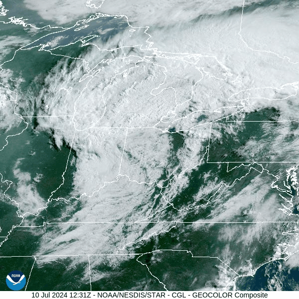 GOES EAST visible satellite loop from about 8 AM to 2 PM EDT on July 10th, 2024 showing post-tropical cyclone Beryl moving across the Great Lakes region |
Flooding
The highest rain amounts fell in the Tippecanoe River Basin and Saint Joseph River Basin in northwest and north-central Indiana. Minor to moderate flooding was observed on July 10th and July 11th on area rivers.
The Norway Dam north of Monticello, IN had a peak flow of 17,000 cfs (cubic feet per second) around 12 AM on July 10th, with flow of 13,000 to 16,000 cfs observed throughout the day. The dam operator also observed some debris in the dam that had to be cleared. A Flood Warning is issued for the Norway Dam whenever the flow is at or above 13,000 cfs. The river gauge there on the Tippecanoe River peaked in Moderate flood stage near 15 ft.
Hydrographs
.jpeg) |
.jpeg) |
.jpeg) |
%20at%20South%20Bend%20(1).jpeg) |
| Tippecanoe River at Norway Dam | Elkhart River at Goshen, IN | Dowagiac River at Sumnerville, MI | St Joseph River at South Bend, IN |
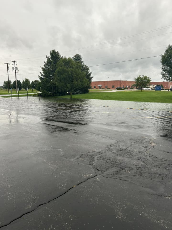
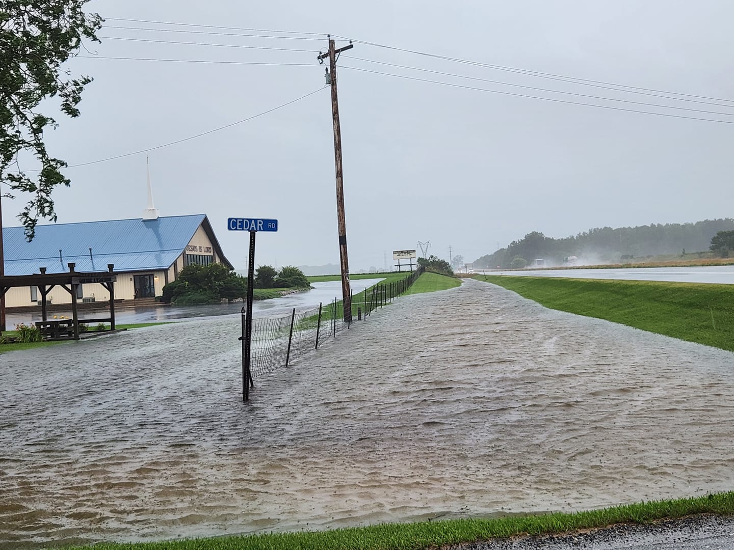
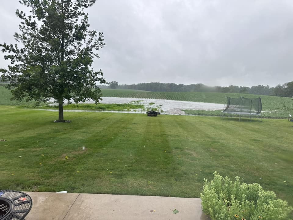
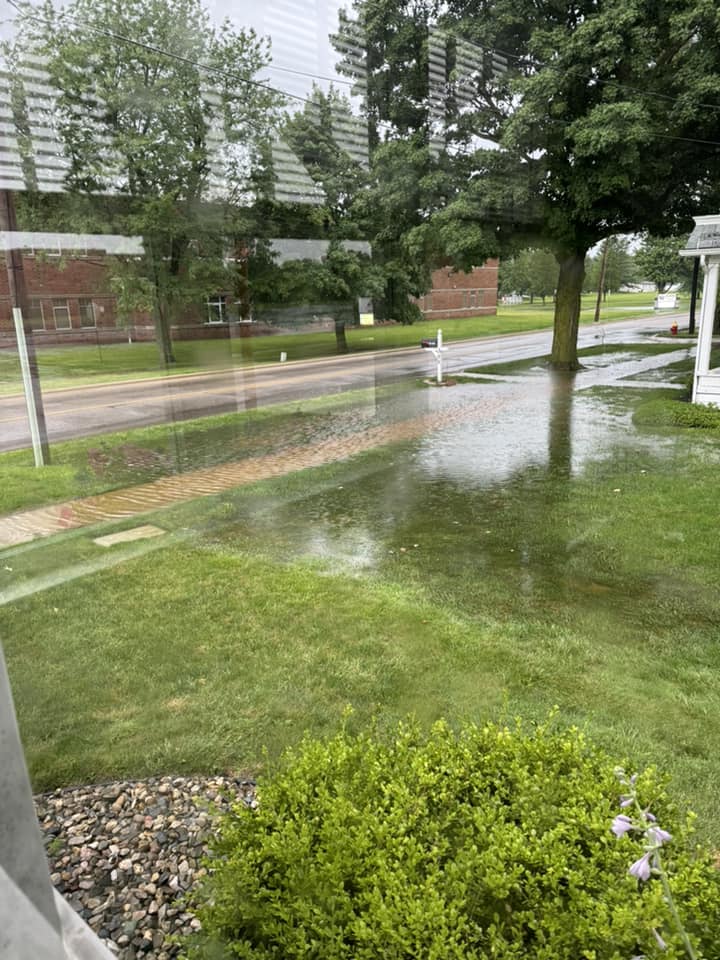
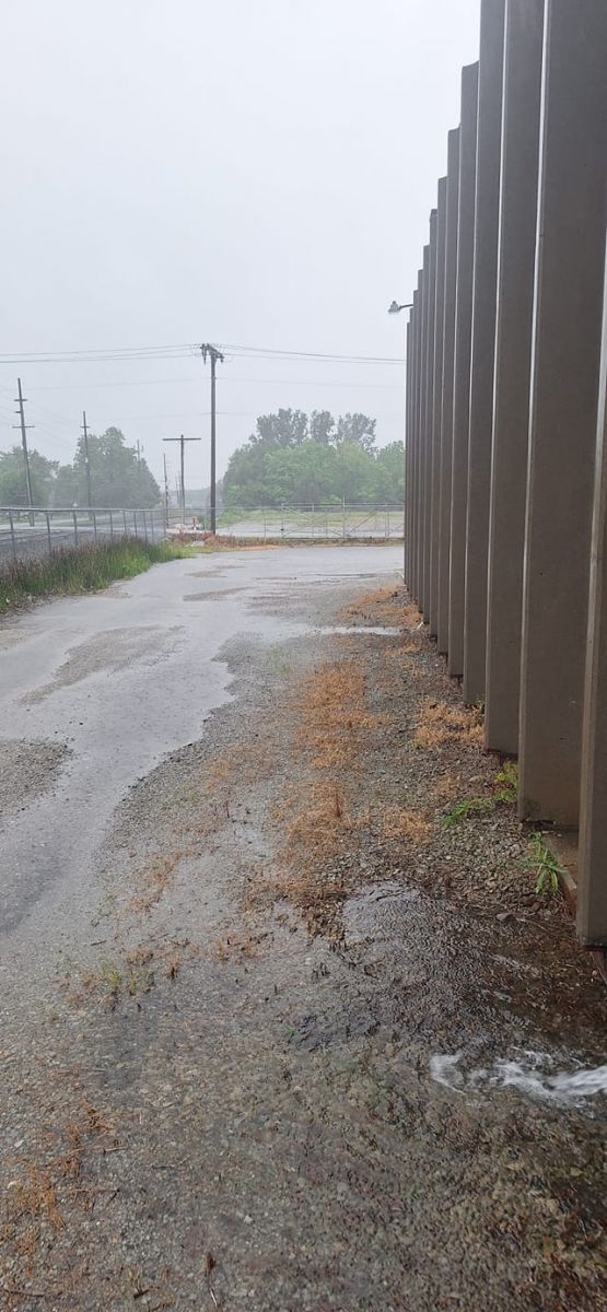
Photos
 |
 |
 |
 |
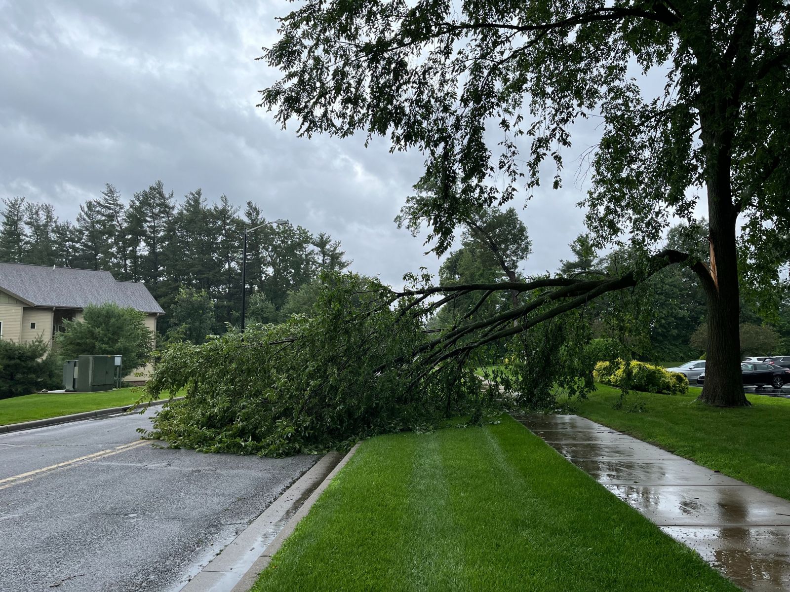
| A large tree limb snapped at ABC 57 on Generations Drive. (ABC 57) |
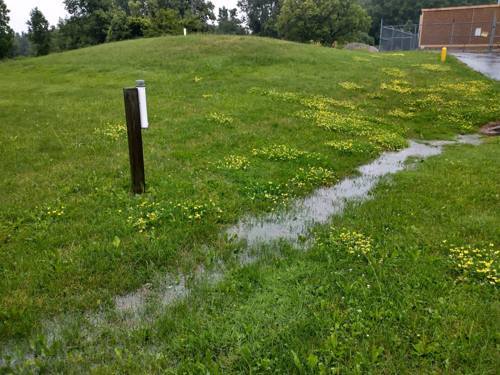
Ponding of water in the grass at NWS Northern Indiana. (NWS IWX Maddi Johnson) |
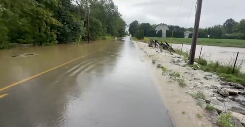
Water covering CR 28 in Elkhart, IN (ABC 57) |
Flooding along CR 17 in Elkhart, IN (Cassie Koziol) |
%20CR%2043%20and%20CR%2013.jpg) |
.jpg) |
 |
 |
| A car in floodwaters near the intersection of CR 43 and CR 13 (DeMarco Brown ABC 57) |
Flooding in Osceola, IN (relayed by Cari Peugeot WSBT) |
Extensive flooding at US 30 and 12th Street near Bourbon, IN (Kris Berger) |
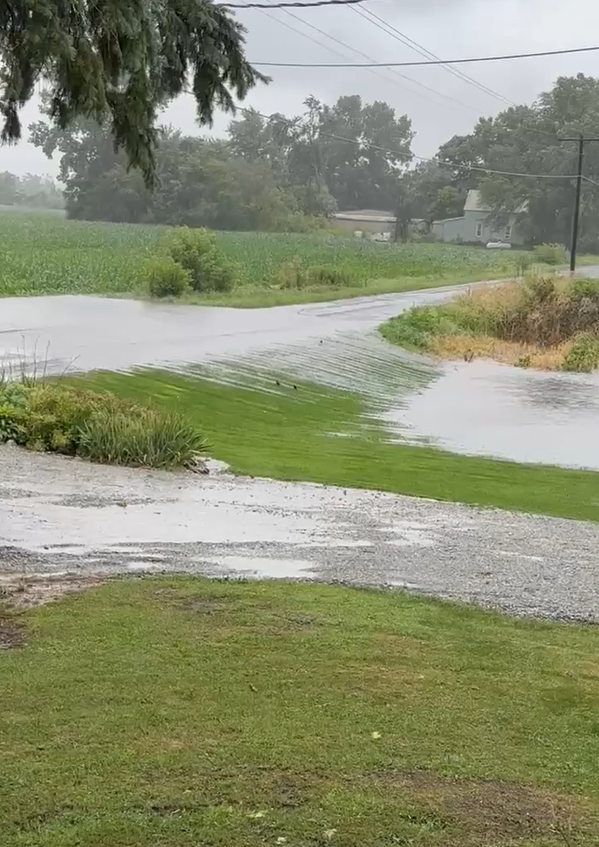
Field flooding in Kosciusko County (Melody Rockhill) |
 |
 |
%20Lake%20Maxinkuckee(1).jpg) |
 |
| Standing water in a yard and into the roadway in Wakarusa, IN where 7"+ of rain fell in 24 hours! (Whitney Kay) |
Flooding in Argos, IN in Marshall County (Courtney Schaefer) |
Flooding at Lake Maxinkuckee in Marshall County, IN (Angela Bern, relayed by Abby Weppler WSBT) |
Flooding in Plymouth, IN (Zachary Edington) |
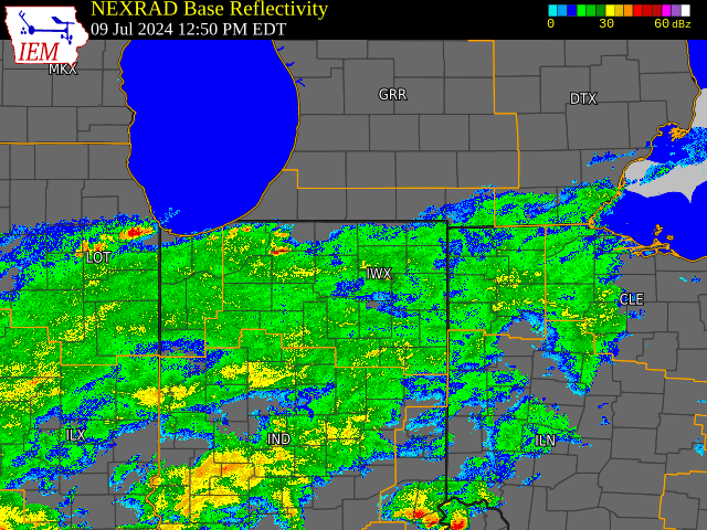
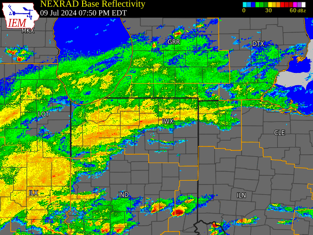
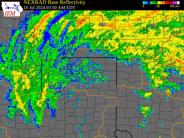
Radar
It took 24 hours for post-tropical cyclone Beryl to move through, with several rounds of rain and multiple stationary/training rain bands that pivoted through the area. The heaviest, most widespread rain fell from about 10 PM EDT July 9th to 2 AM EDT July 10th.
 |
 |
 |
| Radar loop from 1 PM to 9 PM EDT July 9th (courtesy of IEM) | Radar loop from 9 PM EDT July 9th to 4 AM EDT July 10th (courtesy of IEM) | Radar loop from 4 AM to 12 PM EDT July 10th (courtesy of IEM) |
Storm Reports
Public Information Statement National Weather Service Northern Indiana 1020 PM EDT Wed Jul 10 2024 ...PRECIPITATION REPORTS... Location Amount Time/Date Lat/Lon ...Indiana... ...Adams County... 0.8 N Linn Grove 1.07 in 0445 PM 07/10 40.66N/85.03W ...Allen County... 2 SW Wallen 2.50 in 0900 PM 07/10 41.15N/85.19W SPENCERVILLE 2.05 in 1000 AM 07/10 41.25N/84.89W Woodburn 2.8 WSW 1.92 in 0700 AM 07/10 41.12N/84.91W Leo-Cedarville 1.90 in 0955 PM 07/10 41.21N/85.02W Harlan 2.2 ENE 1.86 in 0700 AM 07/10 41.20N/84.88W Woodburn 2.6 NNW 1.74 in 0900 AM 07/10 41.16N/84.88W 2 W Woodburn 1.70 in 0730 AM 07/10 41.13N/84.89W Harlan 3.4 NE 1.69 in 0604 AM 07/10 41.23N/84.87W Fort Wayne 7.6 SE 1.64 in 0700 AM 07/10 41.01N/85.02W 4 S Tuckers Corner 1.54 in 1005 AM 07/10 40.99N/84.94W Fort Wayne 6.8 NE 1.50 in 0700 AM 07/10 41.13N/85.03W Fort Wayne 10.1 WSW 1.49 in 0700 AM 07/10 41.03N/85.32W 2 S Fort Wayne 1.48 in 0405 PM 07/10 41.04N/85.14W Fort Wayne 8.0 N 1.46 in 0700 AM 07/10 41.19N/85.11W Hoagland 1.5 SSW 1.43 in 0700 AM 07/10 40.93N/85.00W Fort Wayne 1.6 S 1.42 in 0700 AM 07/10 41.05N/85.14W Monroeville 0.2 ESE 1.41 in 0700 AM 07/10 40.97N/84.86W Fort Wayne 9.3 W 1.40 in 0700 AM 07/10 41.05N/85.31W New Haven 4.4 NE 1.39 in 0700 AM 07/10 41.12N/84.98W Fort Wayne 1.9 SSW 1.33 in 0622 AM 07/10 41.05N/85.15W Fort Wayne 6.0 N 1.31 in 0700 AM 07/10 41.16N/85.13W 2 E Wallen 1.30 in 0652 AM 07/10 41.16N/85.12W Ellisville 0.3 W 1.25 in 0730 AM 07/10 41.02N/85.29W Fort Wayne 9.1 SE 1.24 in 0700 AM 07/10 40.99N/85.00W Fort Wayne 7.1 WSW 1.20 in 0800 AM 07/10 41.05N/85.27W Fort Wayne 2.6 NW 1.19 in 0700 AM 07/10 41.10N/85.18W Fort Wayne 4.1 NE 1.18 in 0700 AM 07/10 41.12N/85.09W Fort Wayne 1.9 S 1.17 in 0445 AM 07/10 41.05N/85.14W Fort Wayne International Ap 1.06 in 0954 AM 07/10 40.98N/85.18W ...Blackford County... (KA9VIS) Hartford City 0.7 N 0.86 in 0700 AM 07/10 40.46N/85.37W Hartford City 4 ESE 0.53 in 0800 AM 07/10 40.44N/85.29W ...Cass County... 1 ESE Royal Center 2.96 in 0502 AM 07/10 40.86N/86.48W 4 N Dunkirk 2.22 in 0500 AM 07/10 40.81N/86.39W Galveston 2.00 in 1000 AM 07/10 40.56N/86.19W Young America 1.76 in 0800 AM 07/10 40.57N/86.33W Walton 1.55 in 1000 AM 07/10 40.66N/86.22W ...De Kalb County... Ashley 2.93 in 1100 AM 07/10 41.51N/85.13W 2 N Fairfield Center 2.93 in 1206 PM 07/10 41.51N/85.13W 1.7 SE Butler 2.55 in 0810 AM 07/10 41.41N/84.85W Hamilton 3.0 ESE 2.35 in 0730 AM 07/10 41.52N/84.86W Waterloo 2.30 in 0745 AM 07/10 41.43N/85.03W Auburn 0.4 NNW 2.15 in 0816 AM 07/10 41.37N/85.06W Corunna 1.1 S 2.02 in 0700 AM 07/10 41.42N/85.15W Auburn 1.1 NNE 2.00 in 0700 AM 07/10 41.38N/85.05W Auburn 0.2 SE 1.98 in 0800 PM 07/10 41.36N/85.05W 0.6 S Garrett 1.77 in 0700 AM 07/10 41.34N/85.13W ...Elkhart County... Wakarusa 7.50 in 0930 AM 07/10 41.54N/86.01W Goshen 7.00 in 0840 AM 07/10 41.58N/85.83W 2 W Goshen 6.50 in 0910 AM 07/10 41.58N/85.87W Nappanee 6.20 in 0720 AM 07/10 41.45N/85.98W Jimtown 5.63 in 0715 AM 07/10 41.64N/86.02W 2 NW Goshen 5.45 in 0700 AM 07/10 41.60N/85.86W Dunlap 4.80 in 0328 PM 07/10 41.64N/85.92W 3 WSW Dunlap 4.75 in 0550 AM 07/10 41.62N/85.97W Elkhart 4.75 in 0635 AM 07/10 41.69N/85.98W Goshen 3.5 NNW 4.75 in 0724 AM 07/10 41.62N/85.87W Elkhart 3.0 SSE 4.70 in 0800 AM 07/10 41.65N/85.94W Bristol 4.50 in 0430 AM 07/10 41.72N/85.82W New Paris 4.50 in 0930 AM 07/10 41.51N/85.83W Goshen 2.3 WNW 4.42 in 0700 AM 07/10 41.59N/85.88W Middlebury 4.35 in 0800 AM 07/10 41.67N/85.71W Wakarusa 2.4 NNE 4.23 in 0700 AM 07/10 41.57N/85.99W Nappanee 4.8 NE 4.17 in 0700 AM 07/10 41.50N/85.92W Goshen 4.6 N 4.10 in 0700 AM 07/10 41.64N/85.83W 5 N Goshen 4.10 in 0700 AM 07/10 41.65N/85.83W Goshen 1.8 SE 4.04 in 0700 AM 07/10 41.56N/85.81W Goshen 0.3 NE 4.03 in 0800 AM 07/10 41.58N/85.83W 3 W Middlebury 3.99 in 0950 PM 07/10 41.67N/85.77W 2 SSE Benton 3.96 in 0210 PM 07/10 41.48N/85.75W Goshen 1.2 SW 3.94 in 0700 AM 07/10 41.57N/85.85W Elkhart 3.5 ENE 3.77 in 0800 AM 07/10 41.70N/85.90W Goshen 3.0 WSW 3.76 in 0700 AM 07/10 41.56N/85.88W Jamestown 3.73 in 0538 PM 07/10 41.64N/86.04W Goshen 1.4 SSE 3.69 in 0700 AM 07/10 41.56N/85.83W Goshen 3 SW 3.68 in 0700 PM 07/10 41.56N/85.88W Goshen 6.8 NE 3.64 in 0700 AM 07/10 41.65N/85.75W New Paris 1.0 SW 3.60 in 0700 AM 07/10 41.49N/85.84W 2 NNW Dunlap 3.56 in 0535 AM 07/10 41.66N/85.94W Ligonier 4.3 WNW 3.41 in 0800 AM 07/10 41.48N/85.67W Elkhart 4.8 SW 3.32 in 0600 AM 07/10 41.64N/86.04W Syracuse 4.4 NNW 3.17 in 0700 AM 07/10 41.48N/85.77W ...Fulton County... 3 SE Leiters Ford 5.60 in 0830 AM 07/10 41.09N/86.35W Rochester 5.50 in 0900 AM 07/10 41.06N/86.20W Leiters Ford 5.00 in 0830 AM 07/10 41.12N/86.39W Talma 4.90 in 0910 AM 07/10 41.15N/86.31W Kewanna 4.9 S 3.79 in 0700 AM 07/10 40.95N/86.41W Akron 3.40 in 0743 AM 07/10 41.04N/86.03W Rochester 2.4 NW 3.34 in 0700 AM 07/10 41.09N/86.23W Rochester 3.04 in 0700 AM 07/10 41.07N/86.21W Rochester 0.34 in 0915 PM 07/10 41.07N/86.18W ...Grant County... 2.2 N Marion 1.88 in 0700 AM 07/10 40.58N/85.66W MARION 1.85 in 1005 AM 07/10 40.62N/85.71W Grant County Municipal Apt 1.76 in 0955 AM 07/10 40.48N/85.68W Marion 5.6 NE 1.67 in 0600 AM 07/10 40.60N/85.59W (KB9CRA)Gas City 0.3 N 1.63 in 0700 AM 07/10 40.49N/85.61W Marion 6.5 N 1.60 in 0700 AM 07/10 40.64N/85.69W Gas City 1.50 in 0845 AM 07/10 40.49N/85.61W Marion 1.8 NW 1.10 in 0712 AM 07/10 40.57N/85.69W (KD9CQQ)Upland 0.7 ENE 0.77 in 0700 AM 07/10 40.47N/85.50W (KC9QCJ) Shamrock Lakes 3.0 0.66 in 0700 AM 07/10 40.45N/85.45W ...Huntington County... Huntington 2.50 in 0346 PM 07/10 40.88N/85.51W 3 S Goblesville 2.00 in 1112 AM 07/10 40.95N/85.51W Huntington 0.3 W 1.76 in 0700 AM 07/10 40.88N/85.51W Warren 4.9 NNE 1.58 in 0600 AM 07/10 40.75N/85.38W 1.7 E Bowerstown 1.46 in 1000 AM 07/10 40.90N/85.41W 2.4 NW Warren 1.09 in 0945 AM 07/10 40.71N/85.45W Huntington 1.04 in 0955 AM 07/10 40.85N/85.45W Huntington 0.79 in 1008 AM 07/10 40.83N/85.53W ...Jay County... (KB9PPK) Redkey 0.5 SE 1.38 in 0700 AM 07/10 40.34N/85.15W Redkey 0.6 SE 1.10 in 0625 AM 07/10 40.34N/85.14W (W9JKL) Portland 0.6 SSW 1.02 in 0700 AM 07/10 40.42N/84.99W Portland 2.3 S 0.98 in 0700 AM 07/10 40.40N/84.98W ...Kosciusko County... 3 S Oswego 6.00 in 0940 PM 07/10 41.28N/85.79W 2 S Oswego 5.31 in 1224 PM 07/10 41.29N/85.78W Mentone 5.20 in 0700 AM 07/10 41.18N/86.04W 1 SSE James Lake 5.04 in 0441 PM 07/10 41.31N/85.72W 2 NW Tippecanoe Lake 5.01 in 0440 PM 07/10 41.34N/85.78W 2 N Pierceton 5.00 in 0330 PM 07/10 41.23N/85.71W North Webster 2.3 N 4.02 in 0800 PM 07/10 41.36N/85.70W 1 N Lake Wawasee 3.92 in 0200 PM 07/10 41.42N/85.70W North Webster 0.5 SE 3.90 in 1025 AM 07/10 41.32N/85.69W Claypool 3.80 in 0519 PM 07/10 41.13N/85.88W Leesburg 6.7 ESE 3.70 in 0700 AM 07/10 41.31N/85.72W Pierceton 3.67 in 0345 PM 07/10 41.20N/85.71W Warsaw 3.60 in 0800 AM 07/10 41.24N/85.85W 1 SSE Clunette 3.53 in 0540 PM 07/10 41.31N/85.92W North Webster 3.50 in 0730 AM 07/10 41.33N/85.70W Leesburg 3.50 in 0730 AM 07/10 41.33N/85.85W Milford 0.9 N 3.46 in 0700 AM 07/10 41.42N/85.85W Milford 2.7 SSW 3.38 in 0600 AM 07/10 41.38N/85.87W Milford 3.0 E 3.33 in 0800 AM 07/10 41.41N/85.79W Warsaw 2.2 E 3.26 in 1100 AM 07/10 41.24N/85.80W Warsaw Municipal AP 3.25 in 0535 PM 07/10 41.27N/85.83W Warsaw 1.4 N 3.24 in 0746 AM 07/10 41.26N/85.85W Syracuse 3.0 ESE 3.18 in 0800 AM 07/10 41.41N/85.70W Lake Wawasee 3.18 in 0800 AM 07/10 41.40N/85.70W 1 SW Sevastopol 3.17 in 1009 AM 07/10 41.11N/86.04W Warsaw 1.2 NNE 3.03 in 0700 AM 07/10 41.25N/85.84W Warsaw 3.7 E 3.02 in 0730 AM 07/10 41.23N/85.78W Syracuse 3.00 in 0515 AM 07/10 41.43N/85.75W Winona Lake 0.9 SW 2.98 in 0730 AM 07/10 41.21N/85.83W Warsaw 3.0 SE 2.89 in 0700 AM 07/10 41.21N/85.80W Cromwell 2.9 W 2.89 in 0700 AM 07/10 41.40N/85.67W Leesburg 0.1 WNW 2.84 in 0600 AM 07/10 41.33N/85.85W Claypool 1.2 E 2.45 in 0655 AM 07/10 41.13N/85.86W Warsaw 4.6 NNE 2.28 in 0535 AM 07/10 41.30N/85.81W North Webster 0.6 ESE 2.28 in 0800 AM 07/10 41.32N/85.69W ...La Porte County... Michigan City 3.60 in 0300 PM 07/10 41.71N/86.88W Trail Creek 3.50 in 0800 AM 07/10 41.70N/86.86W Wanatah 4.4 ESE 2.95 in 0900 AM 07/10 41.41N/86.81W La Crosse 1.2 W 2.76 in 0800 AM 07/10 41.32N/86.91W Hanna 1.1 E 2.57 in 0800 AM 07/10 41.41N/86.76W La Crosse 3.2 NW 2.41 in 0800 AM 07/10 41.35N/86.93W 1 ENE Michiana Shores 2.38 in 0949 PM 07/10 41.76N/86.80W Rolling Prarie 2.31 in 0100 PM 07/10 41.67N/86.62W La Porte 5.8 SSE 2.25 in 0700 PM 07/10 41.53N/86.66W Kingsbury 1.7 E 2.00 in 0744 AM 07/10 41.53N/86.66W 2 WSW La Porte 1.96 in 0148 PM 07/10 41.59N/86.75W New Carlisle 3.0 WNW 1.85 in 0900 AM 07/10 41.72N/86.57W La Porte 9.2 N 1.78 in 0300 PM 07/10 41.74N/86.70W Mill Creek 1.9 NNE 1.76 in 0620 AM 07/10 41.61N/86.52W La Porte 2.3 ESE 1.76 in 0930 AM 07/10 41.59N/86.68W La Porte 10.9 NNE 1.63 in 0900 AM 07/10 41.76N/86.66W La Porte 1.6 SW 1.62 in 0945 AM 07/10 41.59N/86.73W La Porte 6.8 SW 1.50 in 0800 AM 07/10 41.55N/86.82W La Porte 0.9 SSE 1.42 in 0800 AM 07/10 41.60N/86.71W Michigan City 5.4 S 1.15 in 0800 AM 07/10 41.63N/86.88W La Porte 5.9 NW 1.14 in 0800 AM 07/10 41.66N/86.80W Trail Creek 3.0 SE 1.12 in 0800 AM 07/10 41.67N/86.81W La Porte 1.09 in 0535 PM 07/10 41.57N/86.73W 0.8 W La Porte 0.71 in 1258 AM 07/10 41.61N/86.73W ...Lagrange County... 2 N Shipshewana 5.30 in 0645 AM 07/10 41.71N/85.58W Shipshewana 4.20 in 0900 AM 07/10 41.68N/85.58W Lagrange 4.6 ESE 3.52 in 0915 AM 07/10 41.62N/85.34W Lagrange 3.50 in 0430 PM 07/10 41.64N/85.42W Wolcottville 1.1 WNW 3.21 in 1003 AM 07/10 41.53N/85.39W Howe 3.20 in 0643 AM 07/10 41.72N/85.42W 3 W Shipshewana 3.10 in 0945 AM 07/10 41.67N/85.63W 2 NW Brighton 3.00 in 1230 PM 07/10 41.74N/85.34W LaGrange 1.3 ENE 2.92 in 0655 AM 07/10 41.65N/85.40W Mongo 2.75 in 0937 AM 07/10 41.69N/85.23W Wolcottville 2.70 in 0445 AM 07/10 41.53N/85.37W LaGrange 9.9 E 2.46 in 0800 AM 07/10 41.65N/85.23W Lagrange 9.6 ESE 2.06 in 0700 AM 07/10 41.59N/85.24W ...Marshall County... Bremen 3.9 WSW 5.97 in 0247 PM 07/10 41.43N/86.23W 1.2 W Plymouth 4.76 in 0445 PM 07/10 41.34N/86.34W 2 E Bremen 4.50 in 0737 AM 07/10 41.45N/86.12W Bourbon 4.21 in 0838 AM 07/10 41.30N/86.12W Tippecanoe 0.8 S 4.00 in 0700 AM 07/10 41.20N/86.11W Plymouth 2.5 WSW 3.77 in 0700 AM 07/10 41.33N/86.36W Culver 3.74 in 0935 AM 07/10 41.22N/86.42W 2 E Plymouth 3.55 in 0528 AM 07/10 41.34N/86.27W Culver 1.0 NNW 2.40 in 0700 AM 07/10 41.23N/86.43W ...Miami County... Denver 3.10 in 0133 PM 07/10 40.86N/86.08W Denver 1.3 NE 3.04 in 0700 AM 07/10 40.88N/86.06W Denver 0.5 SSE 2.84 in 0700 AM 07/10 40.86N/86.07W Peru 4.6 SSE 2.39 in 0600 AM 07/10 40.70N/86.02W Macy 2.7 SSE 2.39 in 0700 AM 07/10 40.92N/86.12W Peru 0.2 NNE 2.39 in 0715 AM 07/10 40.76N/86.07W 0.8 NW Peru 2.20 in 0750 AM 07/10 40.76N/86.07W Amboy 1.29 in 1001 AM 07/10 40.59N/85.98W Peru 1.17 in 0930 AM 07/10 40.75N/86.07W Grissom AFB Peru 1.11 in 0630 AM 07/10 40.63N/86.15W Macy 3.6 SSE 1.07 in 0516 AM 07/10 40.91N/86.10W ...Noble County... Kendallville 3.60 in 0248 PM 07/10 41.44N/85.26W Albion 2.8 ENE 3.52 in 0830 AM 07/10 41.40N/85.37W Ligonier 5.3 ENE 3.45 in 0845 AM 07/10 41.49N/85.50W Albion 9.5 SSW 3.26 in 0700 AM 07/10 41.28N/85.51W Albion 2.9 S 3.19 in 0900 AM 07/10 41.35N/85.42W Albion 3.7 S 3.02 in 0930 AM 07/10 41.34N/85.42W Kendallville 4.5 NW 2.80 in 0700 AM 07/10 41.50N/85.31W Cosperville 2.61 in 0530 PM 07/10 41.48N/85.48W Albion 0.5 N 1.98 in 0600 AM 07/10 41.40N/85.42W ...Pulaski County... 5 NW Pulaski 6.90 in 0930 AM 07/10 41.02N/86.73W 2 E Winamac 6.00 in 0504 PM 07/10 41.05N/86.56W 7 NW Pulaski 5.92 in 0522 AM 07/10 41.03N/86.76W 1 ENE Vanmeter Park 5.85 in 0747 AM 07/10 41.09N/86.55W Winamac 9.1 SW 5.80 in 0900 AM 07/10 40.96N/86.73W Pulaski 5.50 in 0545 AM 07/10 40.97N/86.66W Winamac 5.50 in 0630 AM 07/10 41.05N/86.61W Monterey 2.2 WNW 5.21 in 0800 AM 07/10 41.17N/86.52W Monterey 5.21 in 0805 AM 07/10 41.16N/86.48W Winamac 9.9 NW 5.15 in 0800 AM 07/10 41.15N/86.75W Francesville 5.00 in 0700 AM 07/10 40.98N/86.89W Monterey 1.3 WNW 4.85 in 0800 AM 07/10 41.16N/86.51W 3 NE Vanmeter Park 4.65 in 0525 AM 07/10 41.11N/86.52W 1.3 SW Ora 1.12 in 0845 PM 07/10 41.16N/86.56W ...St. Joseph County... 1 ESE Georgetown 5.50 in 0740 AM 07/10 41.73N/86.22W 1 WNW Roseland 4.80 in 0700 AM 07/10 41.72N/86.27W 1 NE Granger 4.50 in 0815 AM 07/10 41.75N/86.12W Walkerton 5.7 ENE 3.97 in 0700 AM 07/10 41.50N/86.39W Walkerton 4.1 ENE 3.96 in 0700 AM 07/10 41.49N/86.41W South Bend 2.2 NW 3.35 in 0630 AM 07/10 41.69N/86.30W 1 N South Bend 3.25 in 0230 PM 07/10 41.69N/86.27W Lakeville 1.5 SSW 3.11 in 0723 AM 07/10 41.51N/86.28W Granger 1.8 ENE 2.98 in 0700 AM 07/10 41.75N/86.11W 1 NNE Indian Village 2.96 in 0230 PM 07/10 41.72N/86.23W South Bend 4.6 SSE 2.94 in 0832 AM 07/10 41.61N/86.24W Granger 2.85 in 0745 AM 07/10 41.74N/86.14W South Bend 4.0 NNE 2.75 in 0825 AM 07/10 41.72N/86.23W South Bend 4.6 SE 2.65 in 0700 AM 07/10 41.62N/86.22W South Bend 3.3 SE 2.62 in 0700 AM 07/10 41.64N/86.23W South Bend International Ap 2.58 in 0954 AM 07/10 41.70N/86.32W South Bend 4.0 SSW 2.42 in 0800 AM 07/10 41.63N/86.31W Mishawaka 2.0 E 2.40 in 0700 AM 07/10 41.66N/86.13W 2 WNW South Bend 2.36 in 0820 AM 07/10 41.68N/86.30W 0.9 W Roseland 2.28 in 0915 AM 07/10 41.72N/86.27W South Bend 1.1 N 2.11 in 0815 AM 07/10 41.69N/86.26W New Carlisle 1.53 in 0730 AM 07/10 41.71N/86.50W ...Starke County... Bass Lake 8.50 in 0143 PM 07/10 41.21N/86.60W Knox 6.00 in 0952 AM 07/10 41.29N/86.62W Winona 4.90 in 0800 AM 07/10 41.24N/86.57W 3.5 N Brems 3.78 in 1000 AM 07/10 41.39N/86.71W Walkerton 4.4 SSW 3.52 in 0900 AM 07/10 41.40N/86.51W ...Steuben County... 2 ENE Crooked Lake 5.25 in 0848 AM 07/10 41.69N/85.00W 3 ENE Lake James 4.40 in 0200 PM 07/10 41.72N/85.01W 1 NNW Lake James 4.00 in 0434 PM 07/10 41.71N/85.05W Angola 4.00 in 0600 PM 07/10 41.64N/85.00W 1 W Clear Lake 3.75 in 0958 PM 07/10 41.74N/84.85W 2 SE Pleasant Lake 3.47 in 0126 PM 07/10 41.55N/84.99W Angola 4.5 NW 3.27 in 0730 AM 07/10 41.68N/85.07W Angola 6.2 NW 3.20 in 0700 AM 07/10 41.71N/85.07W Orland 3.06 in 0937 AM 07/10 41.73N/85.17W 2 E Salem Center 3.00 in 0947 PM 07/10 41.59N/85.11W Hudson 6.4 WNW 2.86 in 0800 AM 07/10 41.58N/85.19W Hudson 4.6 N 2.77 in 0715 AM 07/10 41.60N/85.09W Angola 8.8 ESE 2.73 in 0800 AM 07/10 41.62N/84.83W Hudson 4.1 NNW 2.65 in 0700 AM 07/10 41.59N/85.10W 1 E Salem Center 2.65 in 0730 AM 07/10 41.59N/85.11W 1 WNW Berlien 2.50 in 0716 AM 07/10 41.64N/84.90W 2 SSW Flint 2.50 in 0730 AM 07/10 41.66N/85.14W Angola 4.1 N 2.42 in 0545 AM 07/10 41.70N/84.99W Angola 8.7 ESE 2.40 in 0700 AM 07/10 41.61N/84.84W Hamilton 1.7 E 2.36 in 0700 AM 07/10 41.53N/84.89W Angola 1.2 S 2.22 in 0600 AM 07/10 41.62N/85.00W Pigeon Creek 2.19 in 0815 AM 07/10 41.63N/85.11W Hudson 0.3 SE 1.97 in 0516 AM 07/10 41.53N/85.08W ...Wabash County... Lagro 3.5 ESE 2.20 in 0630 AM 07/10 40.81N/85.67W Wabash 1.5 SW 1.90 in 0700 AM 07/10 40.78N/85.84W Wabash 0.3 NNW 1.89 in 0600 AM 07/10 40.80N/85.83W La Fontaine 0.3 SE 1.56 in 0700 AM 07/10 40.67N/85.72W 3.0 SE Lagro 1.03 in 0915 AM 07/10 40.81N/85.68W 0.7 SE Wabash 0.91 in 0930 AM 07/10 40.79N/85.82W ...Wells County... Ossian 1.30 in 0934 AM 07/10 40.88N/85.17W Markle 5.1 NE 1.05 in 0700 AM 07/10 40.89N/85.28W Ossian 2.4 W 0.94 in 0730 AM 07/10 40.87N/85.21W Craigville 2.7 NW 0.93 in 0800 AM 07/10 40.80N/85.13W Bluffton 0.9 SE 0.83 in 0700 AM 07/10 40.73N/85.16W Bluffton 3.6 N 0.78 in 0700 AM 07/10 40.79N/85.17W ...White County... Monticello 5.5 NNW 5.15 in 0800 AM 07/10 40.82N/86.79W 1 NNW Indiana Beach 4.95 in 0509 AM 07/10 40.81N/86.78W Burnettsville 9.9 NNW 4.74 in 0839 AM 07/10 40.90N/86.65W 1 SSE Wolcott 4.59 in 0506 AM 07/10 40.74N/87.03W 3 WNW Indiana Beach 4.47 in 0511 AM 07/10 40.81N/86.81W 1 SSW Buffalo 4.44 in 0504 AM 07/10 40.87N/86.75W Norway 3.25 in 0945 AM 07/10 40.78N/86.76W Brookston 0.3 SE 3.06 in 0700 AM 07/10 40.60N/86.86W 5.6 N Badger Grove 3.00 in 0700 AM 07/10 40.67N/86.95W 1 WNW Brookston 1.98 in 0452 AM 07/10 40.61N/86.89W Monticello 0.9 E 1.03 in 0700 AM 07/10 40.75N/86.75W ...Whitley County... Columbia City 7.4 N 3.33 in 0703 AM 07/10 41.26N/85.50W Columbia City 0.5 WSW 2.83 in 0905 AM 07/10 41.16N/85.49W South Whitley 2.6 SE 2.80 in 0940 AM 07/10 41.06N/85.59W Columbia City 5.4 N 2.62 in 0700 AM 07/10 41.24N/85.49W Columbia City 6.8 NNE 2.61 in 0700 AM 07/10 41.25N/85.42W 1 SSW Tunker 2.60 in 0930 AM 07/10 41.04N/85.56W Tri-Lakes 3.0 N 2.48 in 0610 AM 07/10 41.26N/85.49W Columbia City 0.2 NE 1.95 in 0640 AM 07/10 41.16N/85.48W Columbia City 4.6 S 1.83 in 0600 AM 07/10 41.09N/85.47W ...Michigan... ...Berrien County... Berrien Springs 5.80 in 0920 AM 07/10 41.95N/86.34W Niles 2.53 in 1007 AM 07/10 41.83N/86.25W Buchanan 1.4 ESE 2.36 in 0700 AM 07/10 41.82N/86.34W Niles 2.7 W 2.10 in 0800 AM 07/10 41.84N/86.30W 1 NE Sawyer 1.75 in 0246 PM 07/10 41.90N/86.57W Stevensville 1.7 SSE 1.26 in 0515 AM 07/10 41.99N/86.51W Stevensville 1.25 in 0810 AM 07/10 42.01N/86.52W 3.7 S Watervliet 1.10 in 0900 AM 07/10 42.13N/86.25W 1 N Benton Harbor 1.00 in 0600 PM 07/10 42.13N/86.45W St. Joseph 2.8 SSE 0.89 in 0700 AM 07/10 42.06N/86.47W Benton Harbor 0.85 in 0453 PM 07/10 42.13N/86.42W St. Joseph 1.5 SSE 0.60 in 0700 AM 07/10 42.08N/86.48W ...Branch County... 4 W Lake of the Woods 5.25 in 0525 PM 07/10 41.85N/85.12W Bronson 4.00 in 1230 PM 07/10 41.87N/85.19W QUINCY 3.32 in 0540 PM 07/10 41.94N/84.90W ...Cass County... 3 NW Mottville 3.40 in 0729 AM 07/10 41.83N/85.80W 2 NNW Edwardsburg 2.55 in 0700 AM 07/10 41.84N/86.10W Niles 3.5 E 2.30 in 0900 AM 07/10 41.84N/86.18W Cassopolis 9.0 SSE 2.07 in 0700 AM 07/10 41.79N/85.95W Barron Lake 2.00 in 0900 AM 07/10 41.85N/86.18W ...Hillsdale County... Reading 4.00 in 0600 PM 07/10 41.84N/84.75W Moscow 1.0 NE 2.94 in 0800 AM 07/10 42.06N/84.50W Osseo 2.7 NE 2.42 in 0830 AM 07/10 41.90N/84.49W Jerome 2.34 in 0214 PM 07/10 42.03N/84.47W Hillsdale 2.5 ESE 2.18 in 0800 AM 07/10 41.91N/84.59W Hillsdale 2.15 in 0535 PM 07/10 41.92N/84.58W Jonesville 5.9 ENE 1.84 in 0615 AM 07/10 42.01N/84.56W ...St. Joseph County... Mendon 5.27 in 0625 AM 07/10 42.01N/85.45W Constantine 4.59 in 0950 AM 07/10 41.84N/85.67W Three Rivers 3.75 in 0800 AM 07/10 41.95N/85.63W Fishers Lake 3.50 in 0332 AM 07/10 41.99N/85.57W Three Rivers 2.4 NE 3.22 in 0700 AM 07/10 41.97N/85.60W 3 ESE Fawn River 3.00 in 0730 AM 07/10 41.77N/85.29W 2.0 SE Mendon 2.71 in 0800 AM 07/10 41.98N/85.43W Mottville 1.95 in 0600 AM 07/10 41.80N/85.76W ...Ohio... ...Allen County... Lima 7.3 SE 3.71 in 0700 AM 07/10 40.66N/84.03W Lima 3.0 SSE 2.47 in 0600 AM 07/10 40.70N/84.10W Lima 2.7 NE 2.38 in 0700 AM 07/10 40.77N/84.08W Bluffton 1.94 in 0925 PM 07/10 40.89N/83.89W Elida 1.4 WNW 1.93 in 0705 AM 07/10 40.80N/84.22W Spencerville 0.3 SSE 1.88 in 0830 AM 07/10 40.70N/84.35W Lima 1 N 1.64 in 0927 PM 07/10 40.78N/84.12W Delphos 2.3 ESE 1.43 in 0600 AM 07/10 40.83N/84.30W ...Defiance County... Defiance 1.14 in 0453 PM 07/10 41.33N/84.43W ...Fulton County... Swanton 4.0 S 2.00 in 0800 AM 07/10 41.53N/83.91W Archbold 4.7 NW 1.19 in 0530 AM 07/10 41.57N/84.36W Archbold 2.4 NW 1.06 in 0700 AM 07/10 41.54N/84.34W Wauseon 1.8 S 1.02 in 0700 AM 07/10 41.53N/84.14W Fayette 4.3 ESE 0.96 in 0700 AM 07/10 41.65N/84.25W 4.6 SW Morenci 0.64 in 0500 PM 07/10 41.66N/84.25W ...Henry County... New Bavaria 2.3 WSW 1.67 in 0746 AM 07/10 41.19N/84.21W DESHLER 1.60 in 0530 PM 07/10 41.20N/83.89W Napoleon 1.2 SSE 1.46 in 0700 AM 07/10 41.38N/84.12W Napoleon 0.6 WSW 1.32 in 0800 AM 07/10 41.39N/84.14W Liberty Center 0.3 NE 1.30 in 0700 AM 07/10 41.45N/84.00W Napoleon 1 SW 1.22 in 0700 AM 07/10 41.38N/84.15W Napoleon 4.5 NNW 1.13 in 0700 AM 07/10 41.46N/84.15W ...Paulding County... Paulding 5.6 ESE 1.02 in 0700 AM 07/10 41.09N/84.49W Paulding 1.4 NNE 0.79 in 0700 AM 07/10 41.15N/84.57W ...Putnam County... 1 N Ottawa 2.10 in 0708 PM 07/10 41.04N/84.04W Vaughnsville 1.62 in 0925 PM 07/10 40.88N/84.15W Ottawa 1.60 in 0532 PM 07/10 41.02N/84.04W Ottawa 2.3 SE 1.55 in 0700 AM 07/10 40.99N/84.02W Ottawa 1.2 ENE 1.52 in 0958 AM 07/10 41.03N/84.02W Leipsic 5.4 W 1.49 in 0700 AM 07/10 41.11N/84.09W Cloverdale 1.05 in 0329 PM 07/10 41.02N/84.31W ...Van Wert County... 2 W Delphos 1.49 in 0934 AM 07/10 40.85N/84.38W Van Wert 1.25 in 0540 PM 07/10 40.85N/84.48W 2 N Wetsel 1.13 in 0540 PM 07/10 40.98N/84.44W 1 WNW Convoy 1.13 in 0540 PM 07/10 40.93N/84.74W Van Wert 0.79 in 0536 PM 07/10 40.87N/84.59W ...Williams County... 3 S Nettle Lake 2.75 in 0540 PM 07/10 41.63N/84.73W Edon 4 S 2.11 in 0400 PM 07/10 41.50N/84.77W Pioneer 2.3 S 2.10 in 0700 AM 07/10 41.65N/84.55W Alvordton 0.5 E 1.87 in 0700 AM 07/10 41.67N/84.42W Bryan 2.1 NW 1.86 in 0630 AM 07/10 41.49N/84.58W 1.2 E Bryan 1.86 in 0800 AM 07/10 41.46N/84.53W &&
Public Information Statement
National Weather Service Northern Indiana
731 PM EDT Wed Jul 10 2024

...HIGHEST WIND REPORTS...

Location                     Speed     Time/Date       Lat/Lon

...Indiana...

...Adams County...
Decatur                      35 MPH    1245 PM 07/10   40.76N/85.06W

...Allen County...
Fort Wayne International Ap  44 MPH    1104 AM 07/10   40.98N/85.18W
1 SE Wallen                  38 MPH    1215 PM 07/10   41.15N/85.15W
Hoagland                     31 MPH    1205 PM 07/10   40.97N/84.96W

...Cass County...
Walton                       57 MPH    0830 AM 07/10   40.66N/86.22W
Logansport                   41 MPH    0735 AM 07/10   40.72N/86.37W

...De Kalb County...
Auburn Dekalb C              36 MPH    1215 PM 07/10   41.30N/85.07W
Garrett                      30 MPH    1130 AM 07/10   41.33N/85.13W

...Elkhart County...
Goshen                       40 MPH    0745 AM 07/10   41.53N/85.78W

...Fulton County...
Rochester                    43 MPH    0915 AM 07/10   41.07N/86.18W

...Grant County...
Grant County Municipal Apt   36 MPH    0935 AM 07/10   40.48N/85.68W

...Huntington County...
Huntington                   35 MPH    1148 AM 07/10   40.83N/85.53W
Huntington                   30 MPH    0115 PM 07/10   40.85N/85.45W

...Jay County...
1 N Portland                 33 MPH    0135 PM 07/10   40.45N/84.98W

...Kosciusko County...
Warsaw Muni                  31 MPH    0855 AM 07/10   41.27N/85.83W

...La Porte County...
La Porte                     33 MPH    0547 AM 07/10   41.57N/86.73W

...Marshall County...
Plymouth Site KC65           39 MPH    0835 AM 07/10   41.37N/86.30W

...Miami County...
Grissom AFB Peru             46 MPH    0851 AM 07/10   40.63N/86.15W
Amboy                        33 MPH    0845 AM 07/10   40.59N/85.98W

...Noble County...
Kendallville                 33 MPH    1215 PM 07/10   41.47N/85.25W

...St. Joseph County...
South Bend International Ap  43 MPH    0824 AM 07/10   41.70N/86.32W

...Starke County...
Knox - Starke Co. Airport    38 MPH    0635 AM 07/10   41.33N/86.67W

...Steuben County...
Angola                       31 MPH    1155 AM 07/10   41.63N/85.08W

...White County...
Monticello - White County Ar 37 MPH    0555 AM 07/10   40.72N/86.77W

...Whitley County...
Northeast Purdue Agricultura 31 MPH    1105 AM 07/10   41.11N/85.40W

...Michigan...

...Berrien County...
1 E Paw Paw Lake             35 MPH    1100 AM 07/10   42.21N/86.25W

...Branch County...
Coldwater                    35 MPH    0955 AM 07/10   41.92N/85.03W

...Hillsdale County...
Hillsdale                    36 MPH    0215 PM 07/10   41.92N/84.58W

...St. Joseph County...
Three Rivers                 30 MPH    0935 AM 07/10   41.97N/85.60W

...Ohio...

...Allen County...
2 WNW Westminster            43 MPH    0255 PM 07/10   40.71N/84.02W

...Defiance County...
Defiance                     39 MPH    0243 PM 07/10   41.33N/84.43W

...Fulton County...
Wauseon                      33 MPH    0435 PM 07/10   41.62N/84.13W

...Putnam County...
Ottawa                       37 MPH    0435 PM 07/10   41.03N/83.98W
Kalida                       31 MPH    0230 PM 07/10   40.98N/84.20W

...Van Wert County...
Scott                        38 MPH    1245 PM 07/10   40.99N/84.58W
Middle Point                 33 MPH    0217 PM 07/10   40.86N/84.45W
Van Wert                     30 MPH    0235 PM 07/10   40.85N/84.48W

...Williams County...
Bryan                        31 MPH    1240 PM 07/10   41.50N/84.56W

...Michigan...

...Maritime Stations...
4 NW Bridgman                34 MPH    0830 AM 07/10   41.98N/86.62W
&&
Preliminary Local Storm Report...Summary
National Weather Service Northern Indiana
1028 PM EDT Wed Jul 10 2024

..TIME...   ...EVENT...      ...CITY LOCATION...     ...LAT.LON...
..DATE...   ....MAG....      ..COUNTY LOCATION..ST.. ...SOURCE....
            ..REMARKS..

1005 PM     Flood            1 W Jimtown             41.64N 86.04W
07/10/2024                   Elkhart            IN   Public

            Report from mPING: Street/road flooding;
            Street/road closed.

0343 PM     Flood            Plymouth                41.35N 86.31W
07/10/2024                   Marshall           IN   Emergency Mngr

            Numerous roads with high water in Marshall
            County. A few roads closed per the emergency
            manager. Estimated 3 to 6+ inches of rain
            fell within the past 24 hours in the county.

0324 PM     Flood            2 E Winona              41.23N 86.53W
07/10/2024                   Starke             IN   Dept of Highways

            Per INDOT, State Road 23 in Starke County
            closed due to high water overtopping a large
            culvert located 0.1 miles north of State
            Road 10.

1230 PM     Non-Tstm Wnd Dmg 1 E Indian Village      41.72N 86.21W
07/10/2024                   St. Joseph         IN   Broadcast Media

            Corrects previous non-tstm wnd dmg report
            from 1 E Indian Village. Large tree limb
            down at ABC 57 on Generations Drive.

1211 PM     Flood            1 W Sandy Beach         42.05N 86.20W
07/10/2024                   Cass               MI   Public

            Reported by Trained Spotter.

1204 PM     Flood            2 E Rousculp            40.66N 84.05W
07/10/2024                   Allen              OH   Public

            Report from mPING: River/Creek overflowing;
            Cropland/Yard Flooding.

1203 PM     Flood            2 SE Yoder              40.67N 84.05W
07/10/2024                   Allen              OH   Public

            Report from mPING: River/Creek overflowing;
            Cropland/Yard Flooding.

1200 PM     Flood            1 NE Yoder              40.70N 84.05W
07/10/2024                   Allen              OH   Public

            Report from mPING: River/Creek overflowing;
            Cropland/Yard flooding.

1046 AM     Flood            1 W Bell Center         40.87N 86.66W
07/10/2024                   White              IN   Public

            Report from mPING: Street/road flooding;
            Street/road closed.

1044 AM     Flood            1 S Foraker             41.49N 85.93W
07/10/2024                   Elkhart            IN   Broadcast Media

            Car in the water (unknown if there were
            rescues) at CR 43 and CR 13 near New Paris.
            Photo relayed by broadcast media.

0956 AM     Flood            2 ENE Woodland          41.58N 86.14W
07/10/2024                   St. Joseph         IN   Law Enforcement

            Elm Rd between Madison Rd and New Rd closed
            due to flooding.

0930 AM     Non-Tstm Wnd Dmg 2 S Bunker Hill         40.64N 86.10W
07/10/2024                   Miami              IN   Public

            limb down, blocking the road near Bunker
            Hill Dragstrip. Report from MPING.

0925 AM     Flood            3 W Niles               41.84N 86.30W
07/10/2024                   Berrien            MI   Public

            Report from mPING: River/Creek overflowing;
            Cropland/Yard Flooding.

0857 AM     Tstm Wnd Dmg     1 SE Logansport         40.74N 86.33W
07/10/2024                   Cass               IN   Public

            Report from mPING: 1-inch tree limbs broken.

0851 AM     Flood            3 WNW Old Tip Town      41.24N 86.16W
07/10/2024                   Marshall           IN   Dept of Highways

            INDOT reports Sr 10 is closed (both
            westbound and eastbound lanes) due to
            flooding near Filbert Rd and Deer Creek.

0830 AM     Non-Tstm Wnd Dmg Rochester               41.06N 86.19W
07/10/2024                   Fulton             IN   Public

            Tree snapped in Rochester. Time estimated
            via radar.

0830 AM     Flood            Plymouth                41.35N 86.31W
07/10/2024                   Marshall           IN   Public

            Ponding of water in yards and in roadways
            after 3 to 6 inches of rain has fallen in
            Plymouth. Multiple reports and photos on
            social media.

0710 AM     Tstm Wnd Dmg     1 WNW Adamsboro         40.79N 86.29W
07/10/2024                   Cass               IN   Emergency Mngr

            Time estimated via radar. Tree down at CR
            450 E and CR 200 N.

0710 AM     Non-Tstm Wnd Dmg 1 WNW Adamsboro         40.79N 86.29W
07/10/2024                   Cass               IN   Emergency Mngr

            Time estimated via radar. Tree down at CR
            450 E and CR 200 N.

0700 AM     Non-Tstm Wnd Dmg 1 NE Tiosa              41.16N 86.20W
07/10/2024                   Fulton             IN   Public

            Tree snapped 7 miles north of Rochester.
            Time estimated via radar.

0654 AM     Tstm Wnd Dmg     1 E Dunkirk             40.75N 86.38W
07/10/2024                   Cass               IN   Emergency Mngr

            Tree down on US 24. Time estimated via
            radar.

0654 AM     Non-Tstm Wnd Dmg 1 E Dunkirk             40.75N 86.38W
07/10/2024                   Cass               IN   Emergency Mngr

            Tree down on US 24. Time estimated via
            radar.

0649 AM     Tstm Wnd Dmg     2 NW Dunkirk            40.78N 86.41W
07/10/2024                   Cass               IN   Emergency Mngr

            Report of a tree down at US 35 and CR 100 N.
            Time estimated via radar.

0649 AM     Non-Tstm Wnd Dmg 2 NW Dunkirk            40.78N 86.41W
07/10/2024                   Cass               IN   Emergency Mngr

            Report of a tree down at US 35 and CR 100 N.
            Time estimated via radar.

0647 AM     Non-Tstm Wnd Dmg 3 NW Idaville           40.79N 86.70W
07/10/2024                   White              IN   Public

            Report from mPING: River/Creek overflowing;
            Cropland/Yard flooding.

0500 AM     Non-Tstm Wnd Dmg 1 SW Georgetown         40.73N 86.52W
07/10/2024                   Cass               IN   Emergency Mngr

            Tree down across the roadway. Time estimated
            by radar.


&&

$$
Environment
 |
 |
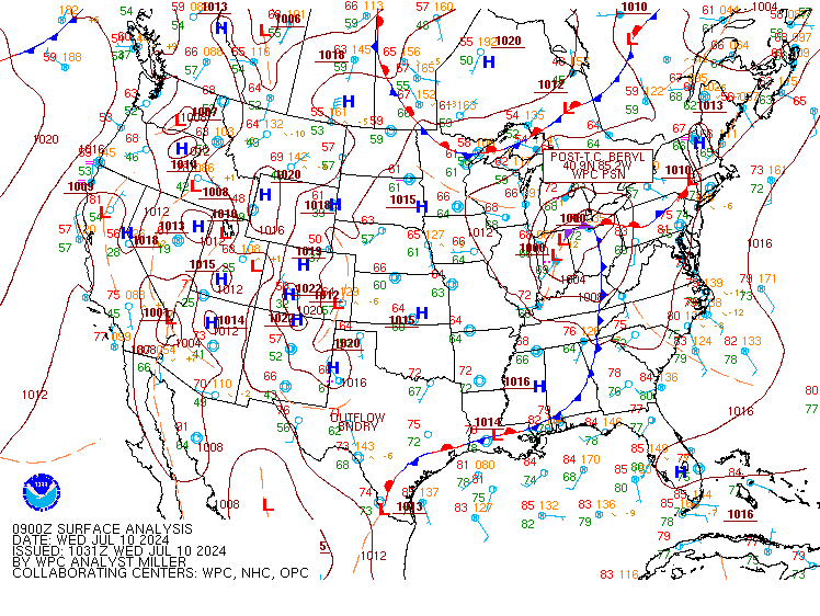 |
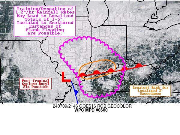
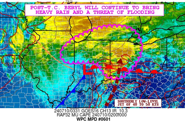
| Figure 1: WPC Mesoscale Precipitation Discussion: #0600 issued at 555 PM EDT July 9th depicting the heavy rain potential and flooding threat | Figure 2: WPC Mesoscale Precipitation Discussion: #0601 issued at 1135 PM EDT July 9th depicting the ongoing heavy rain and flooding threats | Figure 3: The 12Z July 10th surface analysis from NWS WPC showing the center of post-tropical cyclone Beryl centered directly over Fort Wayne, IN |
 |
 |
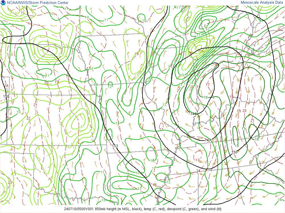
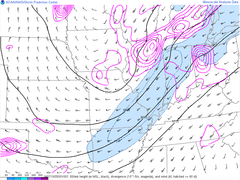 |
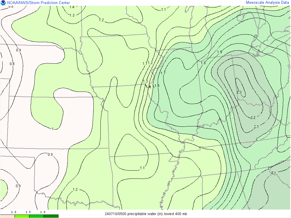
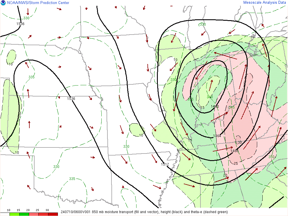
| Figure 4: 5Z July 10th Precipitable Water Values | Figure 5: 6Z July 10th 850mb Heights and Moisture Transport | Figure 6: 5Z July 10th 300mb Heights and Winds |
 |
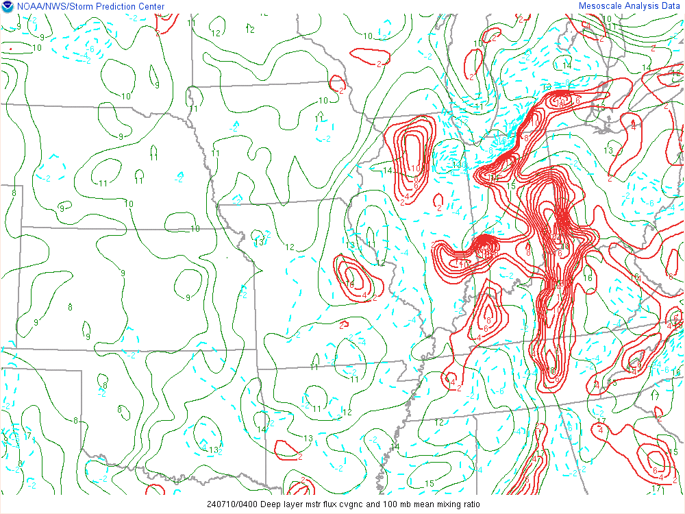 |
 |
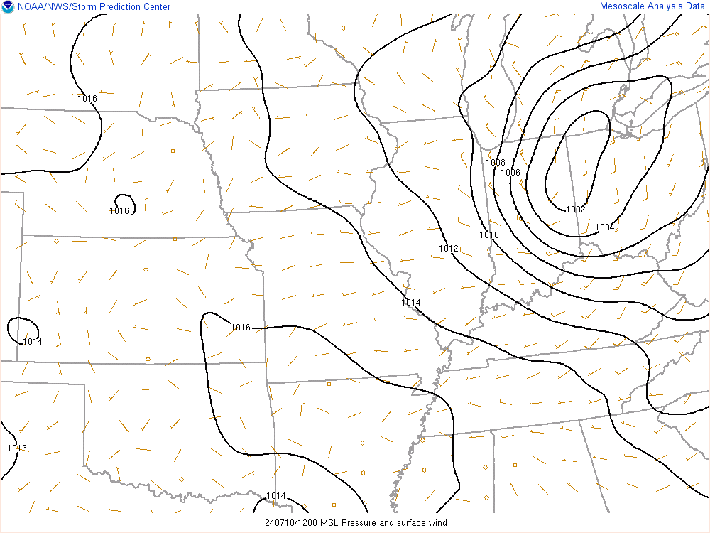
| Figure 7: 12Z July 10th Surface MSL Pressure and Winds | Figure 8: 4Z July 10th Deep Moist Convergence | Figure 9: 5Z July 10th 850mb Dewpoints |
 |
Media use of NWS Web News Stories is encouraged! Please acknowledge the NWS as the source of any news information accessed from this site. |
|

