Overview
A warm front worked slowly north across the area starting late May 23rd into the early morning hours of the 24th. Isolated supercells developed across portions of N and NE Illinois and tracked towards mainly NW Indiana. The storms quickly encountered less unstable conditions east of US-31, which caused rapid weakening. Damage was confined to portions of LaPorte, St Joseph, Starke and Marshall counties in Indiana. While reports of wall clouds were received, no tornadoes were confirmed with damage being in the form of straight line winds, which in spots likely approached between 60 and 70 mph.Damage Pictures
 |
 |
 |
 |
| Tree Damage in South Bend (From WSBT) |
Tree Damage in South Bend (From WSBT) |
Tree Damage in South Bend (From ABC57) |
Tree Damage in South Bend (From ABC57) |
 |
 |
 |
 |
| Tree Damage in Fish Lake, IN (From Melissa Jaenicke) |
Tree Damage in Fish Lake, IN (From Melissa Jaenicke) |
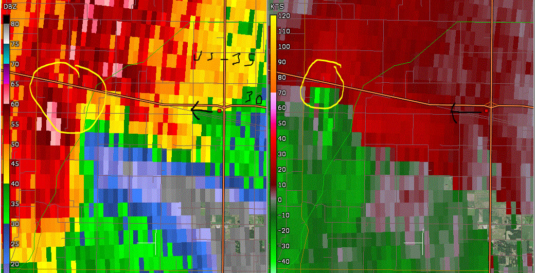
Wall Cloud US30/35 near Hamlet (From Tony Ransbottom) |
Tree Damage and Flooding in South Bend (From Heather Smith) |
 |
|||
| Tree Damage and Flooding in South Bend (From Heather Smith) | Caption (source) |
Caption (source) |
Caption (source) |
Radar
The still radar images show the reflectivity and velocity data at times when most damage or noteable features were reported.
 |
 |
||
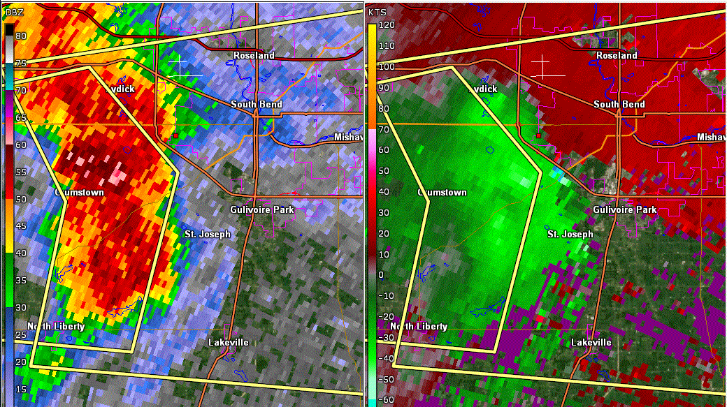
| X marks where the spotter was that took picture of wall cloud near Hamlet. Circled area is approximate location of wall cloud | Lighter green pixels on right indicate strongest winds moving into SW side of South Bend | Caption | Caption |
Storm Reports
PRELIMINARY LOCAL STORM REPORT...SUMMARY
NATIONAL WEATHER SERVICE NORTHERN INDIANA
134 AM EDT SUN MAY 24 2020

.TIME...   ...EVENT...      ...CITY LOCATION...     ...LAT.LON

.DATE...   ....MAG....      ..COUNTY LOCATION..ST.. ...SOURCE.

            ..REMARKS..

0646 PM     MARINE TSTM WIND 2 WNW MICHIGAN CITY     41.73N 86.91W
05/23/2020  M47 MPH          LMZ046             IN   C-MAN STATION

            WIND GUST OF 41 KNOTS RECORDED AT THE
            MICHIGAN CITY LIGHTHOUSE.

1015 PM     TSTM WND DMG     3 N OAK GROVE           41.32N 86.49W
05/23/2020                   STARKE             IN   911 CALL CENTER

            TREE DOWN ON ROAD.

1005 PM     TSTM WND DMG     1 WNW HAMLET            41.38N 86.60W
05/23/2020                   STARKE             IN   911 CALL CENTER

            TREES AND POWERLINES DOWNED.

0800 PM     TSTM WND GST     2 SW MISHAWAKA          41.65N 86.20W
05/23/2020  E60 MPH          ST. JOSEPH         IN   TRAINED SPOTTER


0755 PM     TSTM WND DMG     1 W MISHAWAKA           41.67N 86.19W
05/23/2020                   ST. JOSEPH         IN   PUBLIC

            TREE DOWN ACROSS THE ROAD AT GROVE STREET
            AND W. BENTON STREET. REPORTED VIA TWITTER.
            TIME ESTIMATED FROM RADAR.

0754 PM     TSTM WND DMG     1 SSW SOUTH BEND        41.66N 86.27W
05/23/2020                   ST. JOSEPH         IN   TRAINED SPOTTER

            3 FOOT DIAMETER TREES DOWN.

0748 PM     TSTM WND DMG     3 WSW SOUTH BEND        41.66N 86.32W
05/23/2020                   ST. JOSEPH         IN   EMERGENCY MNGR

            SEVERAL LARGE TREES UPROOTED AND TRAILER
            OVERTURNED NEAR INTERSECTION OF MAYFLOWER
            ROAD AND SAMPLE STREET. TIME ESTIMATED FROM
            RADAR.

0748 PM     TSTM WND GST     3 E CHAIN-O-LAKES       41.71N 86.32W
05/23/2020  M56 MPH          ST. JOSEPH         IN   ASOS


1035 PM     TSTM WND DMG     2 S PLYMOUTH            41.32N 86.32W
05/23/2020                   MARSHALL           IN   911 CALL CENTER

            TWO TREES DOWNED.

1031 PM     HAIL             3 NW TWIN LAKES         41.33N 86.40W
05/23/2020  E0.75 INCH       MARSHALL           IN   PUBLIC

            REPORT FROM MPING: DIME (0.75 IN.).

0921 PM     HAIL             1 W WANATAH             41.44N 86.90W
05/23/2020  E1.25 INCH       LA PORTE           IN   PUBLIC

            REPORT FROM MPING: HALF DOLLAR (1.25 IN.).

0720 PM     TSTM WND DMG     2 NNE FISH LAKE         41.59N 86.53W
05/23/2020                   LA PORTE           IN   TRAINED SPOTTER

            TREES BLOCKING THE ROAD ON 875E. TIME
            ESTIMATED FROM RADAR.

0720 PM     TSTM WND DMG     1 SE FISH LAKE          41.56N 86.54W
05/23/2020                   LA PORTE           IN   PUBLIC

            NUMEROUS TREES DOWN. REPORTED VIA FACEBOOK.
            TIME ESTIMATED FROM RADAR.

0707 PM     TSTM WND DMG     LA PORTE                41.61N 86.72W
05/23/2020                   LA PORTE           IN   LAW ENFORCEMENT

            TREES DOWN.
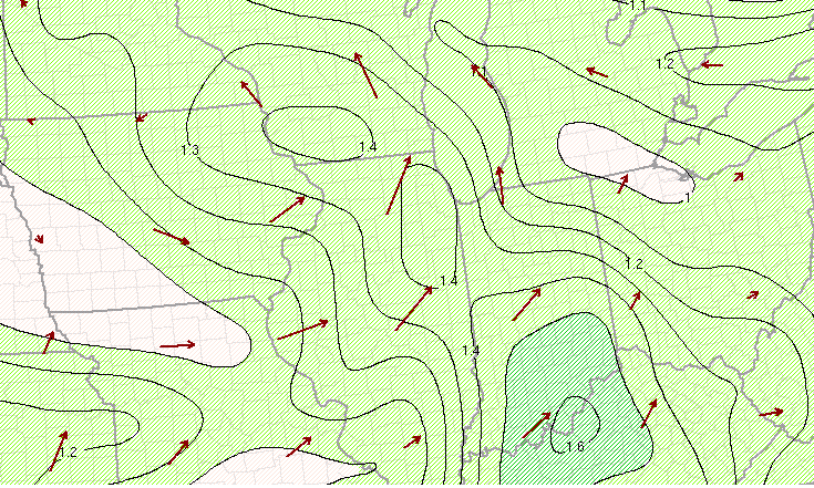
Environment
Coming Soon
 |
 |
 |
| Figure 1: RAP 700 mb heights analysis 5/23/20 21Z | Figure 2: RAP 850 mb heights (black) and dew points (green) 5/23/20 21Z | Figure 3: RAP 850 mb heights and moisture transport (green color-filled) 5/23/20 21Z |
Near-storm environment summary.
 |
 |
 |
| Figure 4: RAP 850 mb moisture transport and PWAT 5/23/20 21Z | Figure 5: RAP Effective Shear 5/23/20 21Z | Figure 6: RAP Effective Helicity 5/23/20 21Z |
Additional environmental data.
| Figure 7: Caption | Figure 8: Caption | Figure 9: Caption |
 |
Media use of NWS Web News Stories is encouraged! Please acknowledge the NWS as the source of any news information accessed from this site. |
|

