Another Round of Thunderstorms Late Wednesday into Early Thursday
20-21 April 2016 |
 |
| Regional radar animation valid from 12:08 am to 1:18 am on Thursday, 21 April 2016. |
| |
| An upper level storm system that originally approached the region late last week, lingered over the Rockies through the weekend and early this week, before finally shifting into the central plains mid-week. This storm system kept the weather unsettled through much of the period, with one final show as it was departing late Wednesday (20 April). Initially, during the afternoon hours of the 20th, isolated storms developed just off the Caprock, including one storm that briefly became severe and dropped hail to 1.5 inches in diameter east of Post (see the picture below). |
| |
 |
| Looking east from Post on Wednesday evening, 20 April 2016. The picture is courtesy of KCBD. |
| |
| The storm east of Post quickly faded by mid-evening, but more widespread thunderstorms then developed across the Texas Panhandle and spread and formed southward through the late evening hours of the 20th into the early morning hours of the 21st. These storms produced swaths of hail that occasionally exceeded quarter size as they plunged southeastward. Additionally, brief heavy rain fell from the strongest storms. The West Texas Mesonet site near Aspermont recorded 1.01 inches in just 10 minutes! To view a preliminary summary of the storm reports for this evening CLICK HERE. |
| |
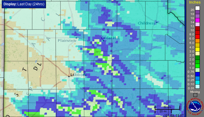 |
| Twenty-four hour radar-estimated and bias-correction rainfall total ending at 5 am on 21 April 2016. |
| |
| As the above map illustrates, most locations across the southern and eastern South Plains into the Rolling Plains picked up a little rain, with localized amounts in excess of an inch. The rain fell on top of several earlier rounds that visited the region since the weekend. This included Tuesday, April 19th, when many locations over northwest Texas saw showers and thunderstorms. Several spots, including Levelland (pictured below), recorded copious amounts of small hail. |
|
|
| Copious amounts of small hail that fell in Levelland on Tuesday, 19 April 2016. The images are courtesy of KCBD and the left image was taken by Jim Wisian. |
| |
| The precipitation was not confined to the South Plains, but stretched over a vast part of the central Rockies into the central and southern plains. Parts of Colorado recorded feet of snow, while near and west of Houston a foot of rain fell over one night. Aside from Far West Texas, which only saw spotty light rainfall, much of the remainder of the state recorded significant, and in spots flooding, rains. Closer to home, much of the eastern South Plains into the Rolling Plains recorded 1 to 3+ inches over the course of the five days of active weather from 16-21 April. |
| |
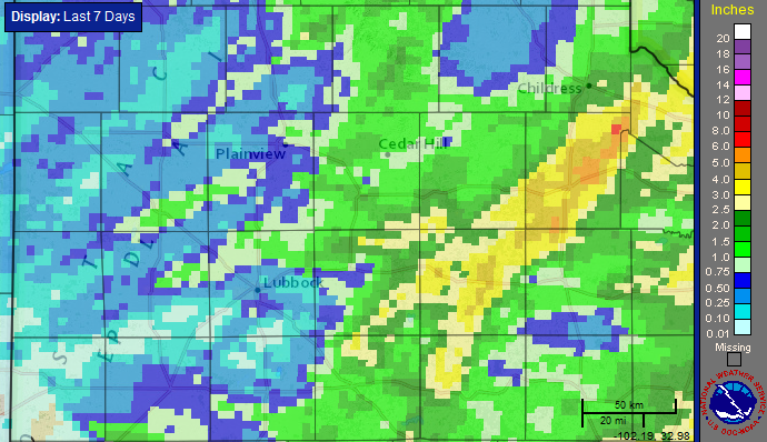
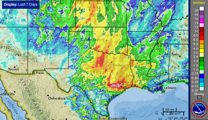 |
| Seven day radar-estimated and bias-correction rainfall total ending at 5 am on 21 April 2016. A zoomed in view centered on West Texas can be VIEWED HERE. |


