Thunderstorms, Sleet and a Little Snow
22-23 February 2016 |
 |
| Regional radar animation from 5:58 to 7:08 pm on Monday, 22 February 2016. An additional radar animation valid from 10:18 to 11:28 pm can be VIEWED HERE. |
| |
| A strong upper level jet stream carved out a storm system across the southern plains to kick off the work week starting Monday, February 22nd. This system managed to tap enough moisture and instability to bring the first widespread precipitation to the South Plains region in over month. After a dry second half of January and first half of February, precipitation finally blossomed again over the region during the late afternoon and evening hours of the 22nd. In fact, there was just enough instability to support scattered thunderstorms Monday evening. In addition, with temperatures on the cool side, in the 30s and 40s, the showers occasionally mixed with sleet in places. |
| |
 |
 |
 |
| Series of visible satellite images captured at 4:45 pm (left), 5:15 pm (center) and 5:45 pm (right) on Monday, 22 February 2016. |
|
| |
| The above series of satellite images show the growing clouds over West Texas shortly before sunset on Monday the 22nd. The tallest clouds, which produced moderate rain and lightning, can be seen casting shadows toward the east as the sun sank low in the western sky. The precipitation continued through the overnight hours, favoring spots off the Caprock. |
| |
 |
| Regional radar animation from 8:38 to 9:48 am on Tuesday, 23 February 2016. |
| |
| By Tuesday, the storm system began to move off to the east, where it encountered greater moisture and instability and went on to produce many severe thunderstorms and tornadoes from the Deep South through the Mid-Atlantic on the 23rd and 24th. Back in West Texas we did see some showery activity, sometimes even in the form of sleet and snow, sweep southward over the region through much of the day Tuesday before diminishing. However, with temperatures on the mild side, no significant travel issues were reported as the sleet and snow generally melted on contact with road surfaces, though light accumulations were observed in grassy areas. |
| |
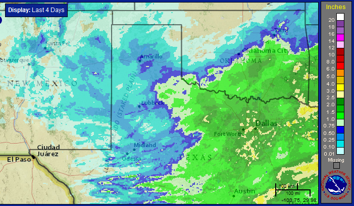 |
| Four-day radar-estimated and bias-corrected rainfall for northwest Texas ending at 4 pm on 25 February 2016. For a closer view of the South Plains and Rolling Plains click on the image. |
| |
| Precipitation amounts for this event were heaviest off the Caprock, with three-quarters to one inch of liquid generally observed from the southeast Texas Panhandle into the eastern Rolling Plains. Childress officially reported 0.74 inches, while Roaring Springs was the big winner recording 1.61 inches. Further to the west amounts were lighter, but most locations recorded a tenth to third of an inch. The moisture and cool weather did provide a brief reprieve from the warm and dry stretch of winter weather. |


