 |
 |
| A map of rainfall totals across the South Plains. from April 12th and April 13th, 2015. The background is radar estimated rainfall, overlaid with gage reports. The gage data is courtesy of the West Texas Mesonet (www.mesonet.ttu.edu). Click on the image to view a larger version. |
| |
| A strong cold front and a upper-level low pressure system combined to bring fairly widespread rainfall across the South Plains area on Monday. The welcome rain came without any severe weather and covered most of the area. As the map above shows, the far southwest Texas Panhandle was about the only area to miss out on soaking rains; receiving only about a tenth of an inch of rain across Parmer County. A band of moderate rain sat nearly motionless across eastern Yoakum and western Terry Counties much of Monday morning, and produced a swath of heavy rainfall, estimated to be nearly 7 inches south of Tokio. This cause quite a bit of flooding across draws, bar ditches and even some roads in that area. |
| |
 |
| Satellite image and geopotential height analysis at 500 mb showing an upper-level storm system tracking out of southern New Mexico across West Texas around midday Monday. Click on the image to view a larger version. |
| |
| As the upper-level storm system approached the region, a cold front raced south through the area with 30 to 40 mph northeast winds. Scattered showers developed, with activity concentrated across the southwest South Plains. The radar image below shows a northwest to southeast band of rain that set up from southern Cochran County to Dawson County. This band remained almost stationary much of Monday morning. |
| |
 |
| Base reflectivity image from the Lubbock radar around 12:30 pm CDT on Monday. This shows a nearly stationary band of moderate to heavy rain stretching from near Plains to near Seagraves. Up to 7 inches of rain fell within this band. Click on the image to view a larger version. |
| |
| A National Weather Service meteorologist/hydrologist drove to the affected area to investigate the affect of the heavy rain. Signficant flooding was documented along several roadways along with some damage to roads. Bar ditches and Sulper Springs Draw were full with rapidly flowing water which was flooding into open fields. |
| |
|
|
| Two pictures from Monday afternoon of flooding along Farm-to-Market 1780 in southeast Yoakum County. Click on each image to view a larger version. |
| |
| |
| |
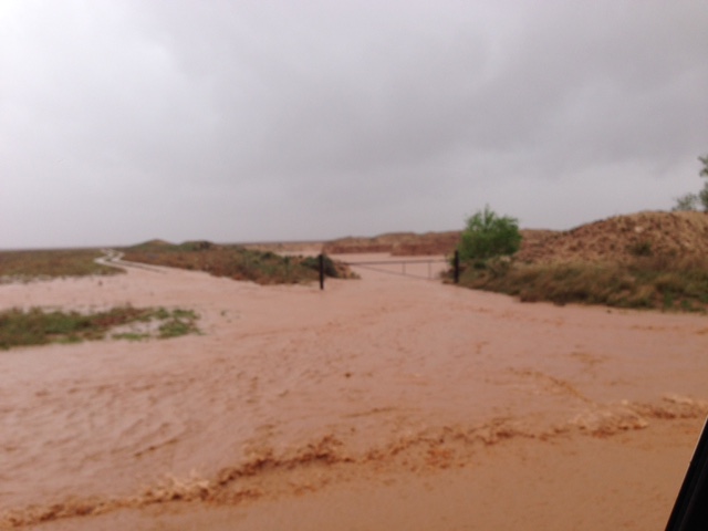
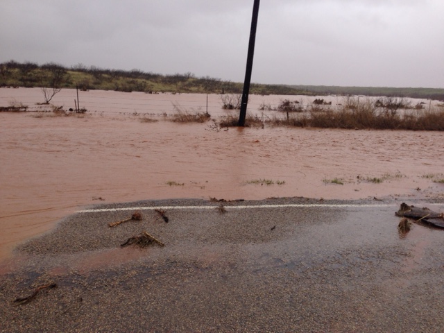
|
|
| Photographs of flooding observed along U.S. Highway 62/385 near Wellman on Monday afternoon. Click on the images to view a larger version. |
| |
| |
| |


