 |
 |
| A beautiful ending to and active afternoon and evening in West Texas. This picture of mammatus clouds was taken from Lubbock looking east on April 8, 2015. The image is courtesy of Erin Shaw. |
| |
| The 2015 severe weather season delivered its first blow to West Texas, both figuratively and literally, during the late afternoon and evening hours of Wednesday, April 8th. The thunderstorms that moved through on the 8th were part beauty (see the above image) and part beast (see the below image). As is often the case in the spring, the dryline was a player, providing the focus for thunderstorm development during the late afternoon hours. In addition, a fast moving upper level disturbance contributed to the turbulent evening. |
| |
 |
| An ominous view as downburst winds and blowing dust are generated beneath high-based showers and thunderstorms Wednesday evening (8 April 2015). This image is looking west from south Lubbock around 7 pm. |
| |
| Initially, during the late afternoon hours, scattered showers and thunderstorms developed along and just east of the dryline, near and east of the edge of the Caprock. Several of these storms became strong and produced gusty winds and small hail, including a report of nickel size hail in Childress. To the west of the dryline, in the drier air on the Caprock, widely scattered high-based showers and thunderstorms also developed. These storms produced only spotty and light rainfall, but they did also generate pockets of strong wind gusts and blowing dust. |
| |
 |
| Regional radar animation valid from 6:48 to 7:58 pm on Wednesday, 8 April 2015. An additional animation valid from 7:48 to 8:58 pm can be FOUND HERE. |
| |
| A notable uptick in thunderstorm coverage and intensity follow during the evening hours as an upper level disturbance rapidly approach from Far West Texas. A line of high-based showers and thunderstorms expanded across the southwest South Plains, before blossoming over the central and eastern South Plains, when they encountered higher moisture levels associated with the retreating dryline. This line of storms, initially deprived of moisture, dropped little in the way of rain, but did generate very strong wind gusts of 60 to 80+ mph. The West Texas Mesonet Station 8 mile west-southwest of Sundown recorded the strongest wind gust of the night, briefly hitting 82 mph. These intense winds racked much of the central and southern South Plains, kicking up plenty of blowing dust as the raced eastward. |
| |
 |
| The back side of a thunderstorm near Ransom Canyon, as viewed from Lubbock on Wednesday evening. The picture is courtesy of Jenn Daniel. |
| |
| When the storms moved into the better moisture they also began producing brief heavy rain as the squall line moved off the Caprock and over the Rolling Plains through the late evening hours. In addition to the rain and gusty winds, a few of the strongest storm cells also dropped pea to quarter size hail as they raced eastward at 50 to 60 mph at times. The fast storm motion limited rain totals, though many spots from the southeast South Plains into the Rolling Plains did receive a quick quarter to half inch. |
| |
|
|
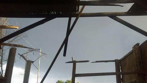
| (Left) Hail observed in Slaton on Wednesday evening, courtesy of Jason Davis and KCBD. (Right) The strong winds removed a roof from a barn in Shallowater. The barn picture is courtesy of Kristal Sebesta and KCBD. |
| |
| Unfortunately, the severe wind gusts did result in damage around the region, with many tree limbs, and in some cases whole trees, being knocked to the ground. Several structures also suffered damage from the strong winds, and power poles were reported down northwest of Slaton. |
| |
|
|
| (Left) Roof damage sustained in Levelland Wednesday evening, courtesy of KCBD. (Right) Tree damage near 91st and Elgin in Lubbock, courtesy of Matt Alvarez and KCBD. |
| |
| A list of the preliminary storm reports collected by the NWS office in Lubbock can be FOUND HERE. Additionally, a plot of the maximum wind gusts and total rainfall observed for this event by the West Texas Mesonet can be viewed below. |
| |


