|
Thunderstorms Bring Widespread Rain to the
Southeast Texas Panhandle and Rolling Plains 16-17 July, 2014
|
||||
 |
||||
| 24-hour radar-estimated rainfall ending at 9 pm on Thursday, 17 July 2014. | ||||
| An unseasonably strong upper level storm system and cold front combined with rich moisture to bring widespread showers and thunderstorms to much of the Texas Panhandle and Rolling Plains Wednesday evening into early Thursday morning (July 16-17th). Initially, during the early evening hours, a small area of thunderstorms (shown below) developed across the southeast South Plains and moved into the Rolling Plains, bringing localized heavy rain. Strong and severe thunderstorms in the Texas Panhandle then congealed into a larger complex of thunderstorms that rolled southeastward through the late night hours, bringing more widespread rain to much of the southern Texas Panhandle, northeast South Plains and Rolling Plains. Rainfall totals of 1 to 2 inches were quite common, with localized heavier amounts. Unfortunately, as the above graphic shows, the heavier rainfall did have a sharp cutoff on the western extent, with locations along and west of Highway 84 receiving little to no rain. | ||||
 |
||||
| View of the top of a storm located to about 60 miles to the east of Lubbock on the evening of July 16th. | ||||
| The below radar animation shows how the thunderstorm activity evolved Wednesday evening (16 July). Early on, much of the activity was confined well to the north and southeast of the South Plains region, aside from the rogue storm moving through the Rolling Plains. | ||||
 |
||||
| Regional radar animation valid from 6:48 to 7:58 pm on 16 July 2014. | ||||
| This changed by late evening as the activity in the Texas Panhandle formed into a larger complex that then moved southeastward, bringing heavy rain to the northeastern South Plains and much of the Rolling Plains early Thursday morning (17 July). The rainfall gradually diminished and shifted eastward by mid to late morning, but not before dropping some welcome rainfall for parts of West Texas. | ||||
|
||||
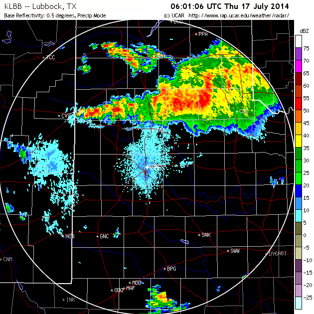
| Lubbock WSR-88D radar images, from left to right, at 1 am, 3 am, 5 am, and 7 am on 17 July 2014. | ||||
| The below plot shows the 24-hour rainfall recorded by the West Texas Mesonet stations. In addition to the rainfall, the cold front brought cool temperatures to the region. Childress recorded its second straight daily record low, when the temperature dipped to 61 degrees early on the 17th. This broke the previous record low of 63 degrees, which was set in 1992. In addition, clouds hung tough much of the day and this led to an unseasonably cool afternoon. Highs only peaked in the 60s and lower 70s, setting several record minimum highs for the date. | ||||
|
|
||
|
Toggle the 24-hr West Texas Mesonet rainfall totals ending at noon on July 17, 2014
|
Toggle the High Temperatures for July 17th
|
Toggle the Low Temperatures for July 17th
|


