|
Two Rounds of Wind and Dust |
 |
| Wall of dust, along a strong cold front, approaching Lubbock around 8 pm on 11 March 2014. |
| A passing upper level storm brought a couple of bouts of strong winds and blowing dust to the South Plains region. Initially, gusty westerly winds developed across much of the Caprock Tuesday morning, and continued through much of the afternoon. Westerly winds sustained at 25-35 mph lofted blowing dust that carried from the South Plains into the southern Rolling Plains and Big Country before settling out in Central Texas during the early evening. Very dry conditions combined with these high winds also led to at least four wildfires, none of which were reported to have caused significant damage or injury. |
 |
| Visible satellite image captured around 5:36 pm on 11 March 2014. Two areas of dust are visible. |
| The wind diminished in the early evening, resulting in a brief pleasant stretch. However, a strong cold front barreling south out of the Texas Panhandle made sure the pleasant weather wouldn't persist by way of lofting copious amounts of dust. North winds of 30 to 40 mph with gusts exceeding 60 mph at times drove a haboob, or large wall of dust, through the South Plains. Widespread degraded visibilities thus occurred throughout the evening, falling to zero at times while frequently remaining at or below 1/2 mile. Travel became extremely difficult due to the dust and other debris quickly blowing across roadways, while the wind made it even more difficult for higher profile vehicles. Fortunately, no fatalities or injuries were reported as a result of traffic accidents or flying debris. The radar loop below shows the haboob, initially near Clovis, spreading southward behind the leading edge of the front. |
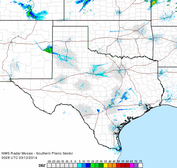 |
| Regional radar loop valid from 7:28 to 8:38 pm on 11 March 2014. |
| Below are the maximum wind gusts and maximum sustained wind speeds recorded by the West Texas Mesonet sites scattered about northwest Texas on Tuesday (11 March) and early Wednesday (12 March). |
|
|
|||
|
Toggle Maximum Wind Gust (mph) on March 11, 2014
|
Toggle Maximum Wind Gust (mph) on March 12, 2014
|
Toggle Maximum Sustained Wind on March 11, 2014
|
Toggle Maximum Sustained Wind on March 12, 2014
|
| Additional pictures captured from around the region can be found below. | |||
 |
|||
| View of the Haboob northwest of Amarillo, looking down from a plane. The picture is courtesy of @RaiderTex52. | |||
 |
|||
| Picture of the Haboob approaching Muleshoe on the evening of March 11, 2014. The image is courtesy of Eric Bales. | |||
 |
|||
| Visible satellite animation valid from 4:15 to 6:45 pm on 11 March 2014. One dust plume can be seen spreading from Snyder to Cross Plains, with another thicker wall of dust racing southward out of the Texas Panhandle along and behind a strong cold front. A few clouds are also visible along the leading edge of the front near the TX/NM line, with other clouds well behind the front. Click on the animation for a larger view. | |||

