|
Active Mid-August Weather |
||||||
 |
||||||
| Picture of a storm rolling into Lubbock from the north at 12:09 am on Thursday (15 August 2013). | ||||||
| Mid-August 2013 brought a change in the weather pattern that resulted in an unsettled stretch of weather for the South Plains region. The upper level steering flow turned northwesterly, which allowed storms that developed over the higher terrain of New Mexico and Colorado to be carried southeastward into West Texas. These thunderstorms encountered very humid air which allowed them to expand into large complexes and dump copious amounts of rain in many locations. | ||||||
 |
||||||
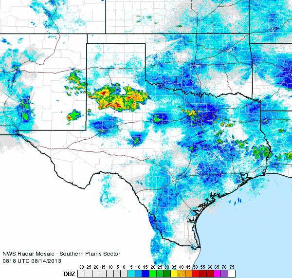
| Regional radar loop valid from 3:18 to 4:28 am on Wednesday (14 August 2013). | ||||||
| Several strong to severe thunderstorms initially developed during the afternoon and early evening hours on Tuesday, August 13th. However, the main show held off until Tuesday night when a large area of thunderstorms congealed and moved down Highway 84, while additional activity blossomed in the Rolling Plains (see the above animation). These storms produced torrential rainfall, with some spots experiencing rainfall rates of 4 to 6 inches per hour. Post saw the brunt of the heavy rainfall, recording over 3.5 inches, most of which fell in one hour. | ||||||
 |
||||||
|
Picture of flooding at the Overton Hotel in Lubbock during the early morning hours on Wednesday. The image is courtesy of Cole Bengford. Click on the image for a bigger view.
|
||||||
| The heavy rainfall resulted in areas of flooding, including in and around Lubbock, where many spots recorded 1-2 inches in an hour. In addition, portions of Highway 84 between Slaton and Post were flooded for a period early Wednesday morning. | ||||||
|
|
||||||
|
|
||||||
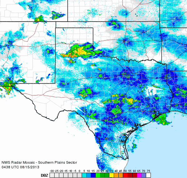
| Regional radar loop valid from 11:38 pm on Wednesday to 12:48 am on Thursday (15 August 2013). | ||||||
|
The next night, another complex of thunderstorms developed to the north and plunged southward across the central and eastern South Plains and western Rolling Plains during the late evening and overnight hours (see the above radar animation). Very heavy rain rates also accompanied these storms, with many locations recording another 1/2 to 2+ inches of rainfall. |
||||||
|
||||||
|
In advance of the large complex of thunderstorms, a lone supercell tracked southward right along Interstate 27 and then Highway 87. This rotating thunderstorm produced hail as large as golf balls west of Plainview near Halfway and a wind gust estimated to 60 mph. As this storm tracked farther southward it developed strong rotation in the low-levels which prompted a tornado warning to be issued. Although no tornado was ever confirmed, several wall clouds and funnel clouds were reported. The storm weakened slightly and lost its strong rotation as it moved across Lubbock, but it still produced heavy rain, frequent lightning and small hail. The photographs below are from this supercell. |
||||||
|
||||||
|
||||||
|
Plotted below are the preliminary storm reports for the 14th and 15th of August. Also available are some of the rain totals for the events, courtesy of the West Texas Mesonet. |
||||||
|
|
|||
|
Preliminary Storm Reports on August 14 and 15, 2013
|
Toggle 24-hr rain totals ending at 7 am on August 14, 2013
|
Toggle 48-hr rain totals ending at 5 am on August 15, 2013
|
|
|
|
 |
|
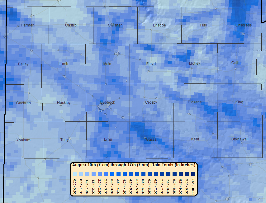
| A map of precipitation estimates for the week of Aug 10 through 16th. Data obtained from water.weather.gov and includes gage and radar information. Click on the map to view a larger version. |


