|
Haboob Hits on Saint Patrick's Day |
||||
|
|
||||
| Picture of a wall of dust (haboob) moving through Lubbock during the evening hours on 17 March 2013. Picture is courtesy of KLBK. | ||||
|
A line of showers and thunderstorms developed across the Texas Panhandle and South Plains region during the late afternoon and early evening hours ahead of a weak upper-level disturbance moving out of eastern New Mexico. The lift provided by this feature created additional forcing near the surface, which combined with weak instability. Unfortunately, wind and dust were the primary outcomes from these high-based showers and storms, though some spots did pick up a little rainfall too. |
||||
 |
 |
 |
||
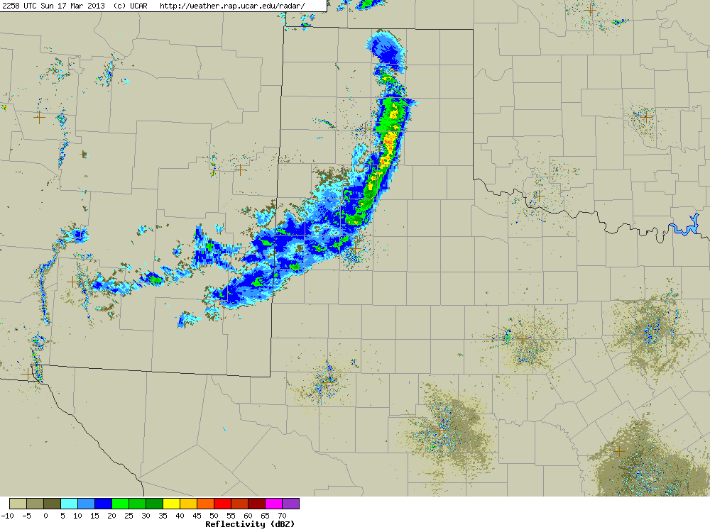
| Regional radar imagery from 4:58 pm (left), 5:58 pm (center), and 6:58 pm (right) on Sunday, 17 March 2013. Lubbock is located at the center of each frame. Click on the images for a larger view. | ||||
| Dry low-level air allowed for several severe wind gusts and associated damage reports on the Caprock as a wall of dust, or haboob, formed along the leading edge of the line of storms. Unfortunately, this relatively dry air generally kept rainfall amounts spotty and limited to a few hundredths of an inch. Radar imagery above depicts the light rainfall that occurred with this line, with higher amounts generally falling north and east of Lubbock. Roaring Springs recorded the highest rainfall amount with 0.05 inches. Sadly, most spots accumulated more dust than rainfall. | ||||
|
|
||||
| Picture of a gustnado (vortex forming on the leading edge of the gust front) captured 16 miles north of Lockney, Texas, around 6:10 pm on 17 March 2013. The picture is courtesy of Connie Barnett and Chris Martin. Click on the picture for a larger view. | ||||
|
Along with the multiple reports of dust being kicked up from the strong to severe winds along the leading edge of this line, a couple of gustnadoes also spun up along the line's gust front. While these may look very similar to tornadoes, they are instead brief ground-based spin-ups that occur along the gust front ahead of a line of showers and/or thunderstorms. They can still produce strong winds and relatively minor damage. For a more thorough definition of gustnadoes, CLICK HERE. |
||||
|
|
||||
| Picture of the wall of dust and an embedded vortex near Plainview, Texas, during the evening of 17 March 2013. The image is courtesy of KLBL. | ||||
|
Aside from the gustnadoes, the most dramatic images from the wild St. Patrick's Day evening weather were from the quickly advancing wall of dust. The above and below images show a few different views captured from around the area during the active evening. In addition, you can view a short (10-second) video captured of the haboob approaching Ropesville HERE. The video is courtesy of Brandan Cruz. |
||||
|
||||
| Pictures of a gustnado near Idalou (left) and of a wall of dust near Levelland (right) during the evening of 17 March 2013. The images are courtesy of KCBD. The left picture was captured from video taken by Tim Spann. | ||||
|
The preliminary storm reports for this event can be FOUND HERE. Additionally, a plot of the storm reports, maximum wind gusts recorded, and rain totals for the event can be found below. |
||||
|
|
|||
|
Toggle Storm Reports
|
Toggle Peak Wind Gust (mph)
|
Toggle Total Rainfall (inches)
|
|
|
Data courtesy of the West Texas Mesonet |
|||


