 |
||
 |
 |
 |
|
A sampling of the wintry scenes from across the area. From left to right the pictures are from near Tulia, in southwest Lubbock, and west of Ropesville. Click on each image to view a larger version. |
||
| ***Note - if you have any pictures or snow reports you would like to contribute, please email them to: sr-lub.webmaster@noaa.gov Or post them to our Facebook page: https://www.facebook.com/US.NationalWeatherService.Lubbock.gov --Thanks |
||||
|
A major winter storm unfolded across West Texas late Sunday into Monday (24-25 February 2013). The storm produced widespread heavy snowfall from the Texas Panhandle southward through the northern and central South Plains and northern Rolling Plains. Snow amounts in excess of a foot were measured across much of Swisher and Briscoe Counties. Elsewhere, three to eight inches were common across all but the most southern areas. The snow piled up into drifts of several feet, and nearly 10 feet in some places, driven by strong northerly winds that gusted to nearly 70 mph at the height of the storm. The blizzard conditions made for some treacherous travel, and many roads were closed down for quite some time, including Interstate 27 between Lubbock and Amarillo. |
||||
 |
||||
|
Animation of water vapor satellite images valid from Sunday evening through Monday afternoon (24-25 February 2013). The loop shows the track of the storm system that brought the wind and snow to West Texas.
|
||||
|
The upper-level storm system responsible for the blizzard dived south from Colorado into New Mexico on Sunday. Then, it turned east Sunday night and approached West Texas. The storm began to intensify, tapping into moisture drawn north and west from the Gulf of Mexico. The moisture even sparked a few severe thunderstorms Sunday night from the Rolling Plains into southwest Oklahoma, one of which dropped half-dollar sized hail near Jayton. In addition, a strong cold front swept south through the Texas Panhandle and South Plains Sunday night into Monday morning. Temperatures which were in the 60s and 70s Sunday, quickly fell as the front passed, and rain showers rapidly changed to sleet, then snow overnight. As the storm tracked right over the South Plains on Monday, the heaviest snow fell across the Texas Panhandle. Finally, Monday evening, the storm moved off into Oklahoma, continuing to produce snow along its path. The animation above shows the track of the storm system across West Texas. |
||||
|
||||
|
|
||||
|
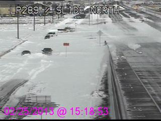
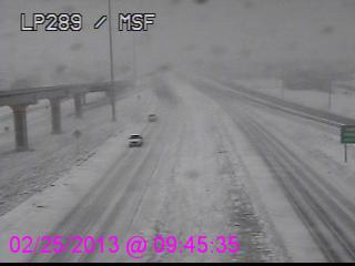
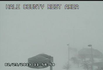
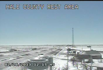
Texas Department of Transportation traffic cameras captured some of the havoc wreaked upon roads across the area. Above and below are some snapshots of conditions found across the area during and after the blizzard. The below set of images demonstrate how poor the visibility was when the strong winds were blowing and the heavy snow was falling during the blizzard. In contrast, the next day, sunny skies and light winds made for great conditions to dig out from the day before. |
||||
|
||||
|
The image below shows many of the snowfall reports received across the area. If you would like to see the snowfall reports in a text format CLICK HERE. In addition, preliminary local storm reports for the event, which also include reports of strong winds and blizzard conditions received, can be FOUND HERE. |
||||
 |
||||
|
Preliminary snowfall totals map for the blizzard of 25 February 2013. The data was compiled from NWS Co-Op and CoCoRaHS reports. Click on the image to view a larger version.
|
||||
| The map of snowfall reports (above) coupled with the visible satellite image from the day after the storm (below) show that there was clearly a tight gradient in snowfall across the South Plains and Rolling Plains into southwest Oklahoma. A tight snowfall gradient also occurred across the northwest Texas Panhandle, though all of I-27 and I-40 in Texas were greatly impacted, making travel difficult to impossible for a while. | ||||
 |
||||
| MODIS high-resolution satellite image capture around 11:30 am the day after the storm (26 February 2013). Click on the image for a larger view. |
||||
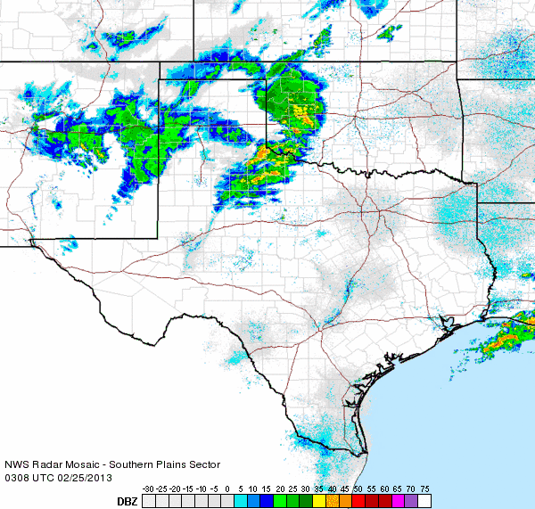
| The following radar animation shows how precipitation was evolving during the approach of the storm system (spinning in New Mexico) Sunday evening. A line of strong and isolated severe thunderstorms were forming into a line across the Rolling Plains while wintry precipitation was developing further to the west, behind a cold front, across the Panhandles into New Mexico. | ||||
|
|
||||
| Regional radar animation valid from 9:08 to 10:18 pm on Sunday, 24 February 2013. | ||||
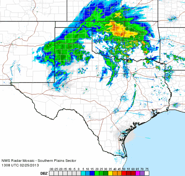
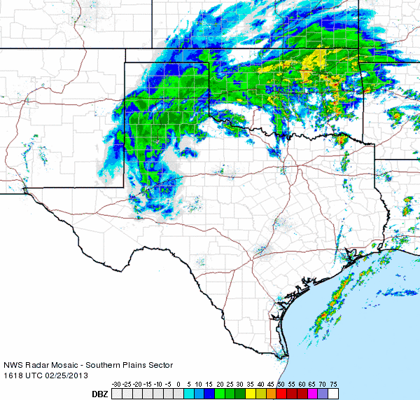
| The below radar animation shows the evolution of the precipitation near the height of the blizzard across the Panhandles into the South Plains Monday morning. Heavy snow, driven by winds gusting in excess of 50 and 60 mph, was wrapping southward around the back side of the upper level storm system centered near Childress. | ||||
|
|
||||
| Regional radar animation valid from 7:08 to 8:18 am on Monday, 25 February 2013. Additional regional radar animations are available at the following links: 10:18 to 11:28 am on Monday ; 11:58 am to 1:08 pm on Monday ; and 2:28 pm to 3:38 pm on Monday. | ||||
|
Click HERE to view a short video showing blowing snow in southwest Lubbock during the day Monday. Additional web pages focused on the 24-25 February Blizzard can be found below: The Texas Tech West Texas Mesonet National Weather Service in Amarillo Also, plots of the peak wind gusts, peak wind speeds and high temperatures on February 25th, as well as the chilly lows the next morning, can be displayed on the map below. The data is courtesy of the West Texas Mesonet. |
||||
|
|
|||
|
Toggle Maximum Wind Gust (mph) on February 25, 2013
|
Toggle Maximum Sustained Wind Speed (mph) on Feb. 25, 2013
|
Toggle High Temperatures for February 25, 2013
|
Toggle Low Temperatures for the morning of February 26, 2013
|
|
Although the storm caused significant hardship to many across the region, it also brought very beneficial moisture. In addition, the snow created some beautiful winter scenery. Here is one such scene of bison enjoying the return of sunshine at Caprock Canyons State Park as temperatures warmed back into the 40s and 50s on Tuesday.
|
||
 |
||
|
The bison herd at Caprock Canyons State Park.
Photo courtesy Chase - Texas Department of Wildlife. |
||
|
More pictures captured from around the area during the blizzard can be found below: |
||
 |
 |
|
| Impacts felt in Ropesville from the snow and wind. Pictures courtesy of Brandan Cruz. Click on the images for a bigger view. | ||
 |
 |
|
| More pictures from near Tulia. Pictures courtesy of Kristina Alexander. Click on the images for a larger view. | ||

