|
Severe Storms Impact the |
|
|
| Supercell thunderstorm captured west of Childress, TX, around 4:45 pm on 30 May 2012. Picture is courtesy of Bruce Haynie. Click on the image for a larger view. |
|
NOTE: Findings from a damage survey can be found following THIS LINK. When following the link, if prompted, select Lubbock NWS. Select the date range to include May 30 at the top of the page, and zoom to Cottle County and Paducah to see wind damage points and a wind swath polygon. Click on the points to see damage photos and descriptions, and click on the pictures within the window to see full size photos. Shapefiles and kml files can be extracted from the page too. SUMMARY BELOW: Scattered thunderstorms quickly developed across the southeast Texas Panhandle Wednesday afternoon (30 May 2012) and then tracked southeast into the Rolling Plains through the evening hours. Strong instability and moderate shear allowed these storms to quickly become severe and to rotate. These rotating supercell thunderstorms produced very large hail, damaging winds, and isolated tornadoes. |
|
|
| Large hail that fell near Estelline around 5:20 pm on 30 May 2012. The image is courtesy of Farrah Farris. Click on the picture for a larger view. |
| These thunderstorms were particularly proficient at producing very large hail. Many locations reported golf ball to baseball sized hail. Several spots north and northeast of Paducah even observed softball sized hail with a lead supercell thunderstorm around 5:30 pm, while another storm generated softball sized hail south of Paducah about two hours later. |
|
|
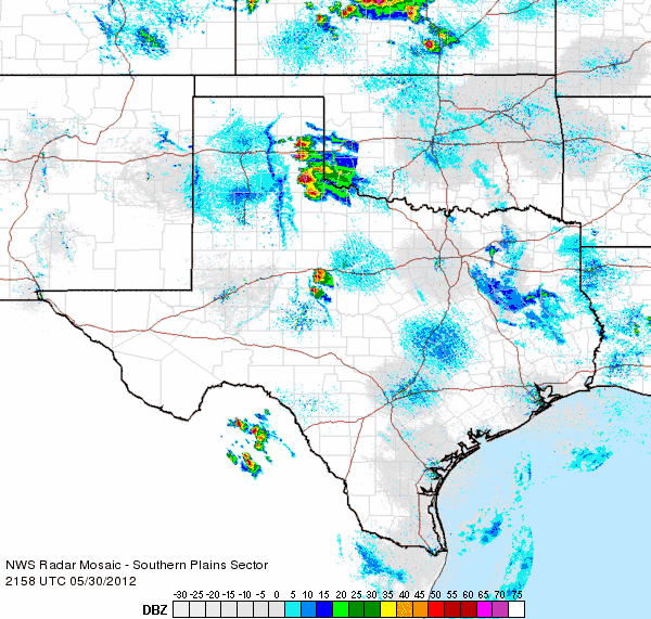
| Regional radar animation valid from 4:58 pm to 6:08 pm CDT on Wednesday, 30 May 2012. |
| In addition to the giant hail, the storms created strong winds that produced damage in several locations, including in and around Plaska (southwest of Memphis in Hall County) and in and around Paducah. Specifically, near Plaska, barns were damaged, power lines downed, trailers were blown over, and a home lost a portion of its roof. Paducah reported several trees down and power knocked out as a result of winds estimated to 80 to 90 mph. A damage survey conducted the next day determined that the damage in Paducah was caused by strong straight line winds, estimated between 70 and 110 mph. |
 |
|
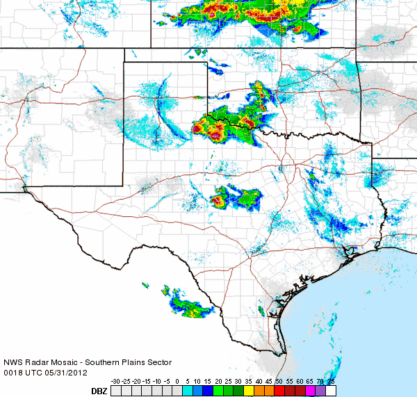
Regional radar animation valid from 7:18 pm to 8:28 pm CDT on Wednesday, 30 May 2012. |
| Several tornadoes were observed with these thunderstorms too, including three non-mesocyclonic tornadoes near Paducah around 6 pm (see below), and another tornado west of Paducah (associated with a different storm) around 7:15 pm. |
 |
| One of three non-mesocyclonic tornadoes observed near Paducah around 6 pm on 30 May 2012. Picture is courtesy of Matt Ziebell. Click on the image for a larger view. Two other non-mesocyclonic tornadoes observed near Paducah by Matt can be found HERE and HERE. |
 |
| Tornado observed about 9 miles west of Paducah around 7:15 pm on 30 May 2012. Picture is courtesy of Matt Ziebell. Click on the image for a larger view. |
| In addition to the hail, wind and tornadoes, the storms also produced frequent lightning which did start several grass fires. The severe storms eventually moved off to the east of the Lubbock County Warning Area by mid-evening. The below precipitation map shows the general track that the storms took. The first two supercell storms moved over nearly the same locations, from southwest Childress County through northeast Cottle County, with the final severe storm path displaced slightly south of the first two. |
 |
| Precipitation, as estimated by radar, from the afternoon and evening of 30 May 2012. Click on the graphic for a larger view. |
| To view a preliminary version of the Local Storm Reports (LSR) for this event CLICK HERE. |
|
|
||
|
Preliminary storm reports from the event. Click on the weather icons to view the full report. Hail size estimates are derived from radar data.
|
||
|
Toggle Storm Reports from 5/30/2012
|
Storm Survey for 5/30/2012
|
Maximum Estimated Size of Hail (MESH) from 5/30/2012
|


