|
Wind and Blowing Dust Visit Again |
||||
|
|
||||
| Graphic displaying the maximum wind gusts observed on 28 February 2012. Data are courtesy of the West Texas Mesonet and the National Weather Service. Click on the map for a larger view. | ||||
| Tuesday started off cool, cloudy and damp, but this quickly changed as strong westerly wind brought much drier air and blowing dust across the region. This weather also created critical fire weather conditions and supported several wildfires across the South Plains during the middle and late afternoon hours. All of this wind was courtesy of a powerful storm system that lifted from the central Rockies into the upper Midwest. As the above map demonstrates, most locations on the Caprock experienced wind gusts of 55 to 60 mph, with weaker winds further east. | ||||
|
|
||||
| Picture of what it looked like at the Lubbock International Airport at 5:48 pm on 28 February 2012. | ||||
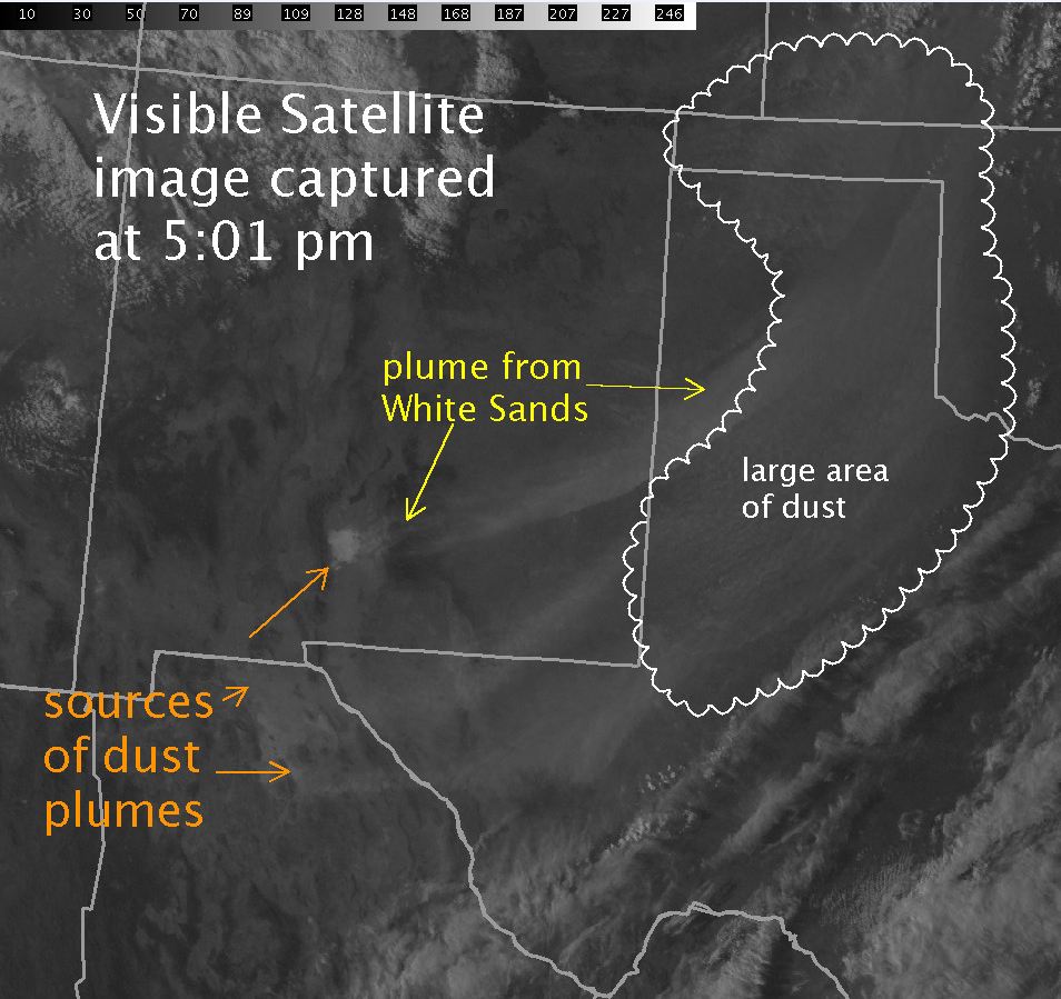
| The strong winds lofted copious amounts of dust into the air (see the above image) and dropped the visibility to 1 to 2 miles over a large region. Much of the dust that was lofted was from relatively close sources, including on the South Plains and into the plains of eastern New Mexico. However, several large dust plumes also originated in central New Mexico and parts of northern Mexico, as the below satellite image illustrates. One large plume had origins in White Sands, NM. | ||||
|
|
||||
| The polar-orbiting MODIS Aqua satellite took an image of the dust storm in progress about 3 pm Monday afternoon. In the image below, the dust plumes can be seen in greater detail. | ||||
|
|
||||
| MODIS Satellite imagery of West Texas on Tuesday, February 28, 2012. Click on the image to view a larger version. Image is courtesy of the NASA/GSFC, MODIS Rapid Response. | ||||
| The warm and windy conditions combined with very dry air spreading in from New Mexico to create critical fire weather conditions. These conditions supported several fire starts across the South Plains, including two fires in Yoakum County and another fire in Lamb County. The largest fire of the day burned around 375 acres near Sudan before being contained. The below image shows two distinct smoke plumes, as sampled by radar, during Tuesday afternoon. | ||||
|
|
||||
| Radar image captured at 4:24 pm on 28 February 2012. Clearly evident are two smoke plumes. Also sensed is a wind shift associated with a Pacific Front that was also the leading edge of a large dust plume that originated from White Sands, NM. Click on the radar image for a bigger view. | ||||
| The below animation shows two different visible satellite views of the blowing dust developing and spreading eastward from New Mexico and Mexico. This dust added to the West Texas dust that was being generated locally. | ||||
|
|
||||
| GOES visible satellite animation (left is GOES-15, right is GOES-13) taken between 7:45 am and 4 pm CST on 28 February 2012. Image is courtesy of CIMSS. A more detailed story from CIMSS can be FOUND HERE. | ||||
| The following images give another taste as to what it was like on the South Plains Tuesday. It took several hours for the dust to settle out once the winds diminished Tuesday evening. | ||||
|
||||
| To view a preliminary storm report for 28 February 2012, CLICK HERE. |


