|
Winter Storm Brings Snow and Bitterly Cold Temperatures |
|
|
|
|
| Light snow blanketing Lubbock on Tuesday morning (February 1, 2011). Click on the image for a larger view. | |
|
A winter storm moved through the region late Monday (January 31st) into Tuesday morning (February 1st), bringing bitterly cold temperatures to the region and accumulating snowfall. 1 to 2 inches of snow fell across most of the Caprock, with locally higher amounts, including an extreme of 4 inches at Friona. Further east, 2 to 3 inches were common along the edge of and off of the Caprock. See the below map for details. |
|
|
|
|
| Plot of snow totals recorded between Monday night and Tuesday morning. Click on the map for a larger view. | |
| To view a statement issued listing snowfall totals recorded between Monday night (January 31st) and Tuesday morning (February 1st) CLICK HERE. | |
|
|
|
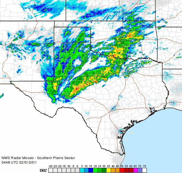
| Radar loop showing a band of snow crossing the South Plains region between 10:48 pm and 11:58 pm on Monday night (January 31, 2011). To view a similar radar loop ending at 9:08 pm on the 31st CLICK HERE. To view a radar loop ending at 12:58 am on the 1st CLICK HERE. | |
|
After Tuesday morning, additionally upper level disturbances brought periods of light snow and flurries to the region through Thursday (February 3rd), though additional snow accumulations were light, generally an inch or less. Any snow that fell was also whipped around by a prolonged period of gusty northerly winds. The above radar loop shows a snow band crossing the South Plains region near the height of the storm Monday night. Below are a couple of images captured while snow was actively falling in Muleshoe and Slaton Monday night. Both locations received about 1 to 2 inches of snow. |
|
 |
 |
| Images captured of snow falling at Muleshoe (left) and Slaton (right) late Monday night (January 31, 2011). The pictures are courtesy of KAMC. Click on the images for a larger view. | |
|
Although the snow that fell did create some travel problems, the biggest story locally was the very cold Arctic air that was ushered into the region on strong northerly winds. The combination of the strong winds and temperatures falling into the single digits above and below zero created dangerously low wind chill readings between -10 and -30 degrees for the region by early Wednesday morning. The below map shows the distribution of the lowest wind chill readings for the morning of the 2nd. To view a statement issued listing the extremely cold temperatures and wind chills measured Wednesday morning (February 2nd) CLICK HERE. |
|
|
|
|
| Plot of lowest observed wind chill readings during the early morning hours of Wednesday morning (February 2, 2011). Click on the plot for a larger view. | |
|
The below map displays the recorded lows Wednesday morning. This invasion of Arctic air brought some of the coldest temperatures West Texas has experienced in quite some time. In fact, the official high temperature at Lubbock on Wednesday topped out at 14 degrees, tying it for the 8th coldest high temperature ever recorded. The coldest high ever recorded at Lubbock is 8 degrees, set on December 24, 1983. The last time Lubbock experienced a high temperature of 14 degrees or less was on January 13, 1997 when the mercury only climbed to 14 degrees (the high on January 12, 1997 was only 12 degrees). Although the lowest wind chills occurred on Wednesday morning, some of the coldest temperatures occurred the next morning where skies cleared out and winds became light. The coldest temperature recorded in the Lubbock County Warning Area was -12 degrees, observed at Friona around 8 am Thursday. Lubbock's lowest official reading during the cold outbreak was 2 degrees, observed on Wednesday morning. Clouds kept temperatures slightly warmer in Lubbock on Thursday morning when the low "only" dipped to 5 degrees. To view a more complete listing of the frigid lows that occurred during this cold stretch CLICK HERE. |
|
|
|
|
| Plot of observed low temperatures Wednesday morning (February 2, 2011). The data is courtesy of the NWS COOP observers, the West Texas Mesonet and the National Weather Service. Click on the plot for a larger view. | |
|
Also of note, the 3-day period from Tuesday through Thursday (February 3-5th) had highs of 20 degrees or less (with highs of 19, 14 and 20 degrees, respectively). This has happened only 2 other times in Lubbock records, January 8-10, 1973 (with highs of 19, 15 and 17 degrees, respectively), and a 5-day stretch from December 21-25, 1983 (with highs of 15, 14, 10, 8 and 17 degrees, respectively). Finally, the last time the temperature at Lubbock officially fell to 0 degrees or less was way back on December 23 of 1989, when the mercury bottomed out at -1°F. The coldest temperature ever recorded was -17°F on February 8, 1933. To view more cold weather climatology for Lubbock CLICK HERE. |
|


