|
Moderate to Heavy Rainfall Soak Much of the South Plains Region
Friday and Saturday, June 19th and 20th. |
 |
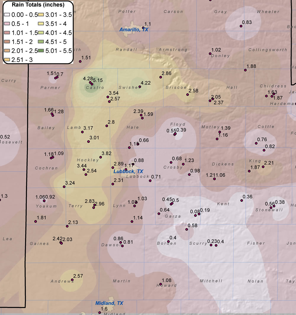
| Map of rainfall that fell across the region from 19-21 June 2009. The map was created using information gathered by the NWS Cooperative Observers, the Texas Tech West Texas Mesonet, and official NWS observation stations. Click on the image for a larger view. Additionally, you can view a map of rainfall totals from 13-21 June 2009 by CLICKING HERE. |
Friday night and Saturday morning, a band of moderate to heavy rain showers and thunderstorms set up across the Texas South Plains, bringing up to five inches of rainfall. Generally, the heaviest rain fell in a north-south band from Terry County to Swisher County. More rain fell across portions of Swisher and Castro counties Saturday afternoon that is not reflected in the rainfall summary found at the bottom of the page. The rain was a result of a rich plume of tropical moisture flowing northeast from the eastern Pacific into West Texas. An upper-level ridge of high pressure along the Gulf Coast and a upper-level trough of low pressure across the desert southwest help to steer the moisture into West Texas. In addition, the remnants of a tropical depression which made landfall near Mazatlan Mexico brought added moisture and lift. The image below is a satellite image from Saturday morning showing the northward moisture stream from northern Mexico across across West Texas.
 |
| "Water Vapor" satellite image at 845 am on the 20th. This sensor channel is sensitive to moisture in the middle to upper levels of the troposphere. The reddish colors are indicative of dry air while the blue/green color show high moisture levels. Click on the image for a larger version. |
Friday evening, thunderstorm activity blossomed across eastern New Mexico and the Permian Basin; then gradually shifted north and east into western South Plains. Rainfall amounts decreased markedly east of interstate 27/U.S. 87 as upper-level lift and storm motion favored the western areas - although spotty showers still brought some local amounts up to about a half inch across the Rolling Plains.
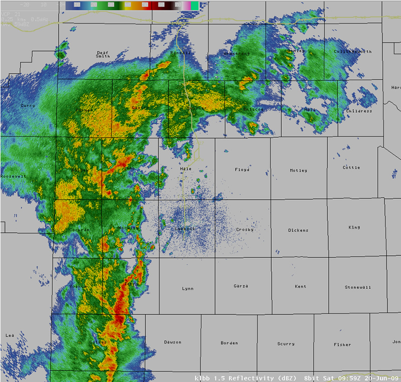
The following is a sequence of hourly radar images from the Lubbock radar from 5 am to 8 am when the band of heavy rain showers set up across the western and central South Plains:
 |
 |
|
| 5 am (10 UTC) | 6 am (11 UTC) | |
 |
 |
|
| 7 am (12 UTC) | 8 am (13 UTC) | |
|
Images of reflectivity from the National Weather Service WSR-88D radar. Please click on each image for a large version. |
||
Once the sun came up Saturday morning, the storm activity also showed up well on the visible satellilte imagery (although storm intensity was decreasing by that time).
 |
| The visible satellite image from around 9 am CDT Saturday morning the 20th. Click on the image for a larger version. |
The following is a summary of the 24-hour rainfall amounts (1 pm Friday to 1 pm Saturday) across the region.
The rainfall totals listed are from automated gages around the region including mostly West Texas Mesonet
(www.mesonet.ttu.edu) stations and area airports.
...24 hour Rainfall Totals Through 1 pm CDT Saturday....

 ANTON              3.42 IN
 CLOVIS MUNICIPAL   2.56 IN
 REESE CENTER       2.53 IN
 AMHERST            2.47 IN
 OLTON              2.45 IN
 ANDREWS            2.27 IN
 SUNDOWN            2.24 IN
 LEVELLAND          2.00 IN
 TULIA              1.96 IN
 WOLFFORTH          1.88 IN
 BROWNFIELD         1.81 IN
 AMARILLO AIRPORT   1.71 IN
 SEMINOLE AIRPORT   1.40 IN
 LUBBOCK AIRPORT    1.40 IN
 SEAGRAVES          1.33 IN
 DIMMITT            1.27 IN
 DENVER CITY        1.21 IN
 SEMINOLE           1.14 IN
 HART               1.09 IN
 PLAINVIEW          1.00 IN
 HEREFORD AIRPORT   0.95 IN
 TATUM              0.92 IN
 NORTHWEST LUBBOCK  0.91 IN
 CLOVIS             0.78 IN
 MORTON             0.74 IN
 LAMESA             0.71 IN
 O`DONNELL          0.70 IN
 MULESHOE           0.68 IN
 HEREFORD           0.68 IN
 PLAINS             0.67 IN
 SLATON             0.59 IN
 ABERNATHY          0.56 IN
 TAHOKA             0.55 IN
 SILVERTON          0.47 IN
 PAMPA              0.47 IN
 MCLEAN             0.46 IN
 ROARING SPRINGS    0.46 IN
 FRIONA             0.44 IN
 CLARENDON          0.42 IN
 MEMPHIS            0.42 IN
 CHILDRESS          0.36 IN
 WHITE RIVER LAKE   0.35 IN
 FLUVANNA           0.31 IN
 RALLS              0.30 IN
 DORA               0.29 IN
 CHILDRESS AIRPORT  0.28 IN
 GAIL               0.26 IN
 GOODLETT           0.22 IN
 GUTHRIE            0.21 IN
 GRAHAM             0.20 IN
 PADUCAH            0.19 IN
 FLOYDADA           0.19 IN
 NORTHFIELD         0.15 IN
 POST               0.09 IN
 SPUR               0.09 IN
 TURKEY             0.05 IN
 SNYDER AIRPORT     0.04 IN
 LAKE ALAN HENRY    0.03 IN
 JAYTON             0.01 IN

