|
5 MAY 2006 SEVERE THUNDERSTORMS and TORNADOES EVENT
|
 |
|
SUMMARY AND DAMAGE IMAGES |
|
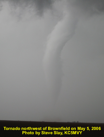
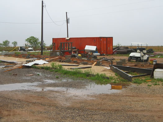
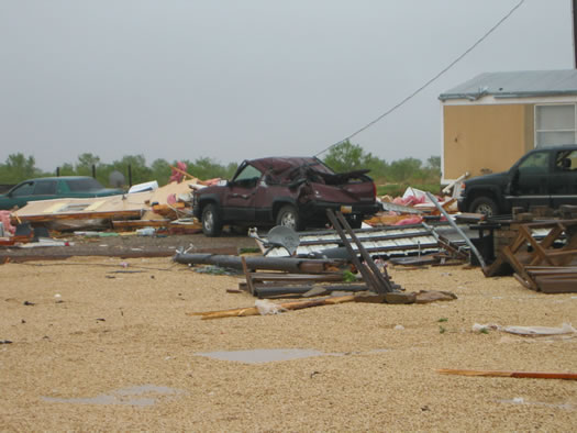
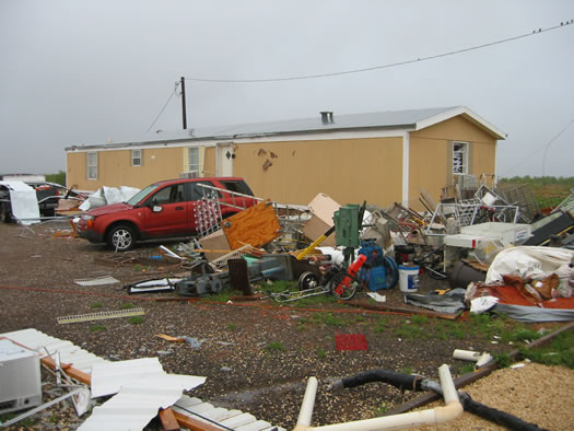
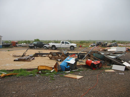
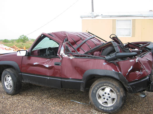
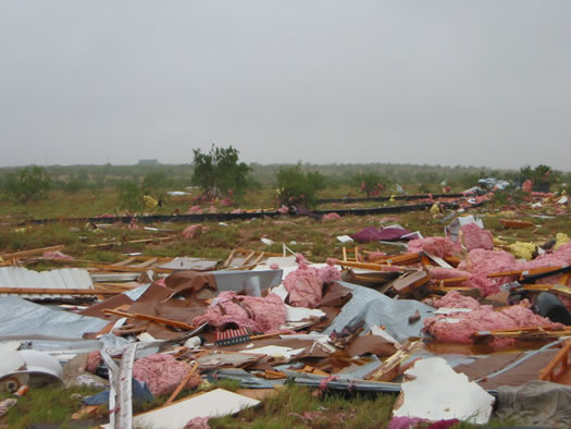
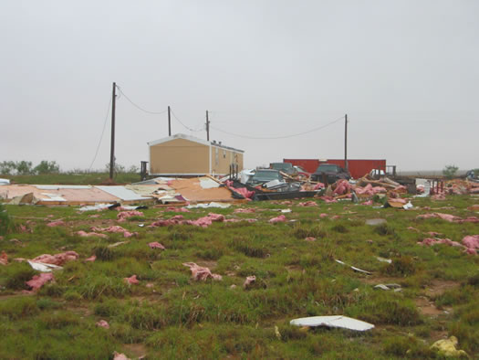
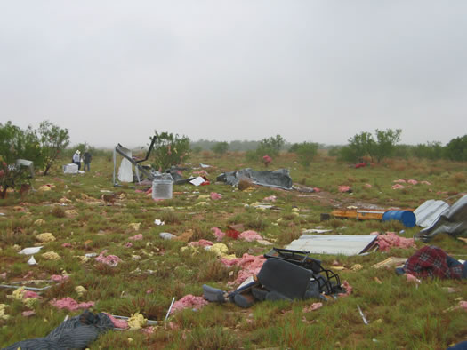
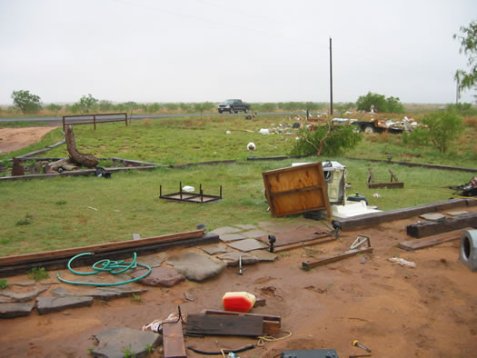
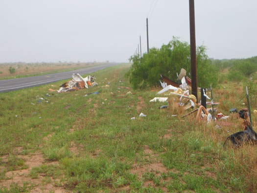
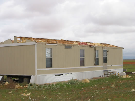
...NWS CONDUCTS DAMAGE SURVEY FOLLOWING MAY 5 2006 SEVERE WEATHER IMPACTS... On Friday May 5, 2006, another outbreak of severe thunderstorms tracked across much of the South Plains and Rolling Plains. Numerous reports of damaging wind and large hail were reported. In addition to the severe winds and hail, five tornadoes were reported. Out of the twenty four counties serviced by NWS Lubbock, seven were impacted by severe thunderstorm activity and included the following: Lynn, Lubbock, Terry, Stonewall, Garza, Yoakum and Briscoe. On Saturday May 6 2006, the National Weather Service in Lubbock dispatched an assessment team to investigate damage reported at many locations. The following report is a summary of the teams findings. The assessment team, comprised of Steve Cobb, NWS Lubbock Science and Operations Officer, and Brian LaMarre, NWS Lubbock Warning Coordination Meteorologist investigated impact areas across portions of Garza County and Terry County. Damage survey results indicated a mixture of straight-line thunderstorm wind, as well as another type of damaging thunderstorm wind known as a microburst. In addition to damaging wind, a number of tornadoes developed over rural areas and were witnessed by trained spotters. Between the hours of 6:00 PM and 7:05 PM, five tornadoes developed over portions of Terry, Yoakum and Lynn counties. 1. Terry County - 6:00 PM to 6:02 PM - 12 miles northwest of Brownfield. No damage. The circulation associated with the above tornado underwent cycles of lifting off the ground and lowering to the ground. The third connection with the ground persisted for seven minutes and the tornado destroyed two center pivot irrigation units. 4. Lynn County - 7:00 PM to 7:02 PM - 6 miles west of New Home. No damage. Significant property damage - and one injury - resulted from severe thunderstorm wind in Garza and Terry counties. The most serious damage and one related injury occurred in the vicinity of Lake Alan Henry. 1. Lake Alan Henry area (Garza County) - approximately 2 miles northeast of Justiceburg, TX. All damage was produced by a severe, wet microburst oriented from a north direction and spreading outward toward the south, southeast and southwest. Time of impact - 7:30 PM to 7:40 PM. There was significant and extensive damage assessed at a small mobile home community approximately 0.2 miles west of FM2458 (one mile north of the intersection with FM3519). Four mobile homes were positioned in a square configuration around a center courtyard. Two mobile homes were oriented along a line from east to west; and two mobiles homes were oriented along a line from north to south. To illustrate this configuration, imagine looking at a square in front of you - facing south. In looking forward, with your back to a north wind, the lines (or positions of the mobile homes) to your left and right are situated from north to south - or in line with a wind blowing from north to south. The bottom and top lines of the square (or positions of the mobile homes) are situated from east to west - or against the flow of a wind blowing from north to south. The mobile homes situated from east to west were completely destroyed as the center of a severe, forward moving microburst impacted the area. The debris and steel-frame structure of the northern home (bottom line of the square) impacted two vehicles that were parked in front of the adjacent home on the right-hand side of the square. The debris pushed the two vehicles 30 to 40 feet. The debris of this mobile home was blown up to 40 yards into an open field to the southwest. One vehicle was crushed by the weight of the flying debris. Another vehicle, a large truck, was reported by one of the residents to have been lifted in the front-end and then pushed across the yard. The tracks on the ground from the rear tires were noted by the survey team. Both vehicles were turned approximately 90-degrees from their original position - facing east - to along the debris path facing in a south direction. The debris and steel-frame structure of the southern home (top line of the square) was also completely removed from its foundation and blown 30 to 40 yards to the southeast into the open field. Lighter debris was also scattered over 100 yards to the south. Four other vehicles in the yard of the small mobile home community were also damaged from flying debris. The front-end of a large truck was struck by a dumpster blown to the south across the yard over 100 feet. A small SUV, positioned in front of the home on the right-hand-side of the square, was impaled by a ladder blown into the side window. A large railroad boxcar, located near the northern mobile home (bottom line of square) showed no signs of disturbance. The two other mobile homes, configuring the left and right sides of the square, sustained roof and window damages. An object impaled the top of the western home and residents reported major damage to the inside of the home due to the wind rushing through the home. Both remaining homes were oriented parallel to the wind direction. No anchoring points could be found on the two homes that were destroyed. However, two uninstalled auger anchors were found near the northern home. Estimated wind speeds between 95 and 105 mph produced the damage. The Texas Tech West Texas Mesonet station located one mile northwest of Lake Alan Henry measured a wind gust of 79 mph from the west/northwest at 7:40 PM. The following are some images from the damage to the mobile home community (please click on an image to enlarge it - large images are approx one megabyte each). All photographs were taken by the NWS Lubbock Damage Survey Team.
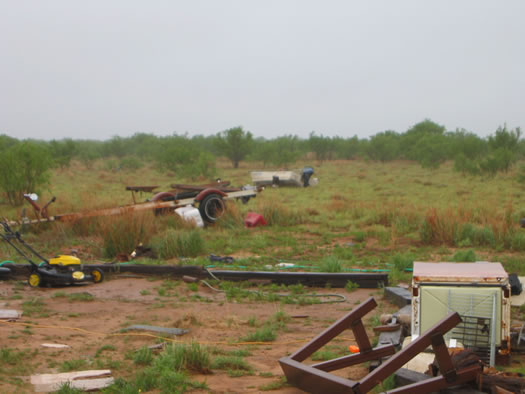
2. Lake Alan Henry area (Garza County) - approximately 2 miles northeast of Justiceburg, TX. All damage was produced by a severe, wet microburst oriented from a north and northwest direction - spreading outward toward the south and southeast. Time of impact - 7:30 PM to 7:40 PM. There was extensive damage assessed to a mobile home along and just west of FM2458 (one mile north of the intersection with FM3519). The area was 0.2 miles east of the damage mentioned above. An approximate 30 foot trailer home was destroyed with debris blown 90 to 100 feet to the south and southeast of its original location. Similarly, a small boat was blown 30 to 40 yards to the south. One man was in the trailer home at the time of impact and was rolled and carried with the structure as it was torn apart by the severe winds. The man suffered injuries and was taken to the hospital for treatment. Debris from the trailer home was also scattered across FM2458 to the southeast into a field up to 0.2 miles. Estimated wind speeds of 70 mph produced the damage. The Texas Tech West Texas Mesonet station located one mile northwest of Lake Alan Henry measured a wind gust of 79 mph from the west/northwest at 7:40 PM. The following are some images from the damage to the mobile home and boat (please click on an image to enlarge it). All photographs were taken by the NWS Lubbock Damage Survey Team.
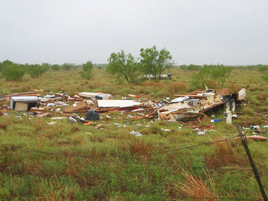
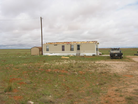
3. Garza County (southeast). Additional and minor damage was noted in the assessment within one mile of the above impact zones with minor roof and sign damage. Minor damage along FM3519 toward Lake Alan Henry was also noted to area roofs. A metal travel trailer port was blown over from north to south 0.2 miles from a local business. And, just past the entrance to the Lake Alan Henry boat ramp, a sign was pushed over supported by four-inch, hollow stakes in a northwest to southeast direction. Time of impact - 7:30 PM to 7:40 PM. Estimated wind speeds of 60 to 65 mph produced the damage. 4. Garza County (West Central). Minor damage to trees were noted in the vicinity of Close City or about 6 miles west/northwest of Post, TX along CR399 north of Highway 380. Time of impact - 6:59 PM. Estimated wind speeds of 60 mph produced the damage. 5. Terry County. Across relatively rural areas of the county, between 8:00 PM (central) and 8:15 PM (southeast), severe thunderstorm winds damaged the roof of two mobile homes east and southeast of Wellman. One of the roofs was completely torn off, approximately two miles southeast of Wellman with debris scattered one-tenth of a mile south into an adjacent field. The home was anchored on a concrete slab. A third mobile home sustained minor roof damage five miles northeast of Wellman with minor debris scattered across the road from northwest to southeast. Additionally, reports were received of several utility poles downed over the southeast portion of the county. Estimated wind speeds of 60 to 70 mph produced the damage. The following are some images from the damage in Terry County (please click on an image to enlarge it). All photographs were taken by the NWS Lubbock Damage Survey Team.
The National Weather Service in Lubbock would like to thank all of the first response officials; emergency management and media affiliates; Skywarn spotters and media storm chasers; and members of the local communities across the area for providing invaluable information during the warning process.
|

