Alabama Tornado Database
|
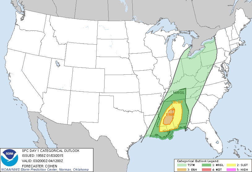
| 2015 Tornado Occurrences (32) |
| # in Year |
Year |
Month |
Day |
Time (CST) |
County |
Damage Scale |
Maximum Path Width (Yards) |
Path Length (Miles) |
Fatalities |
Injuries |
Location |
| 32 |
2015 |
12 |
25 |
1655 |
Jefferson
Event Overview
Storm Event
Storm Survey
Storm Information
Damage Video
Damage Video
News Article
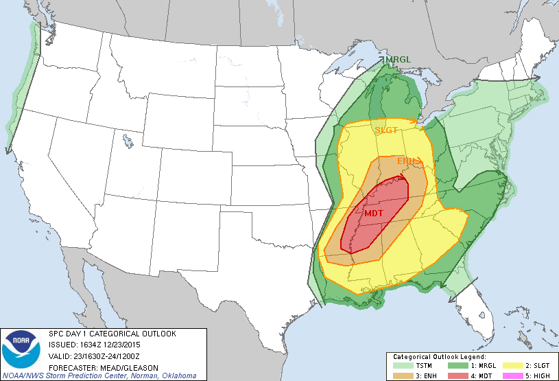
Slight Risk |
F2
Polygon Warnings
|
130 |
0.88 |
0 |
2 |
0.6 SE Midfield - 0.3 SSE Grasselli
NWS Meteorologists determined a tornado touched down in Midfield with a fairly brief but wide damage path, with a core of concentrated significant damage. Initial damage was found near Downey Street and 51st Street, where trees were toppled and snapped. This damage was rated at EF-1 intensity. The tornado then tracked northeast where EF-2 damage occurred along Jefferson Avenue SW and Park Ave SW, bounded by 50th Street to the south and 49th Street to the north. Here, residential homes were heavily damaged, with two homes flattened. Many trees were also snapped and uprooted. A rapid decline in damage intensity was observed as the tornado moved northeast, with EF-1 and EF-0 damage consisting of roof damage, as well as snapped and uprooted trees stretching from Grasselli Boulevard to Carver Avenue SW and 45th Street SW. There were a total of about 50 homes impacted, with approximately 15 that were uninhabitable.
Start: 33.4433/-86.9137
End: 33.4454/-86.8987
|
| 31 |
2015 |
12 |
25 |
1529 |
Tuscaloosa
Event Overview
Storm Event
Storm Survey
Storm Information
Slight Risk |
F0
Polygon Warnings
|
185 |
4.98 |
0 |
0 |
4.4 S Coaling - 0.7 SE Dudley
NWS Meteorologists surveyed tornado damage just south of Coaling in Tuscaloosa County. The tornado was weak and rated an EF-0 with highly spotty damage consisting of snapped trees. The area of rotation then weakened as it moved northeast across I-20 in Tuscaloosa County, before entering Jefferson County and rapidly intensifying near Lipscomb.
Start: 33.1063/-87.3473
End: 33.1624/-87.2933
|
| 30 |
2015 |
12 |
24 |
0434 |
Barbour
Event Overview
Storm Event
Storm Survey
Storm Information
Slight Risk |
F0
Polygon Warnings
Tornado Watch |
125 |
3.16 |
0 |
0 |
5 SSW Garmon Crossroads - 1.1 WNW Hells Crossroads
NWS Meteorologists determined a weak tornado touched down just east of Hurricane Creek along County Road 44, snapping and uprooting several trees along the roadway and damaging two sheds. The tornado then continued northeast, uprooting a couple of trees along State Highway 239. The tornado weakened further and dissipated near McCall Road, where only minor tree damage was noted. A special thanks go out to the Barbour County Emergency Management Agency for their assistance on the survey.
Start: 31.8829/-85.5918
End: 31.9082/-85.5469
|
| 29 |
2015 |
12 |
24 |
0341 |
Barbour
Event Overview
Storm Event
Storm Survey
Storm Information
Slight Risk |
F0
Polygon Warnings
Tornado Watch |
100 |
3.60 |
0 |
0 |
1.2 WNW Batesville - 2.3 ESE Spring Hill
NWS Meteorologists determined a tornado touched down just east of Comer and southwest of U. S. Highway 82. Several trees were snapped and uprooted along U. S. Highway 82. The tornado continued northeast, dissipating close to County Road 89 (Springhill Road), where only minor tree damage was noted. A special thanks go out to the Barbour County Emergency Management Agency for their assistance on the survey.
Start: 32.0270/-85.3390
End: 32.0636/-85.2953
|
| 28 |
2015 |
12 |
23 |
1900 |
Lauderdale
Event Overview
Storm Information
Moderate Risk
Moved into Tennessee
|
F2
(F2)
Polygon Warnings
Tornado Watch |
150
(400) |
7.44
(14.87) |
0
(0) |
1
(1) |
2 N Waterloo-8 NE Waterloo
A tornado touched down initially near the intersection of County Road 14 and County Road 54 north of Waterloo Alabama, in extreme western Lauderdale County. Multiple trees were snapped and uprooted along the nearby creek and along County Road 54. The next available damage was viewed along County Road 1 south of County Road 40. Many softwood and hardwood trees were snapped and uprooted along the hillside into the neighboring valley. The tornado damaged a single family home, removing large portions of the roofing material and damaged the Williams Chapel Presbyterian Church where nearby residents were taking shelter. The tornado crossed County Road 1, leaving almost no tree untouched in a large stand of pine trees. The tornado continued over the hill to County Road 40, where the most significant damage was observed. The tornado snapped numerous hardwood trees south of County Road 40, caused minor damage to a single family residence and pushed a mobile home off its foundation. Upon crossing County Road 40, the tornado tore almost the entire roofing structure off a single family home, injuring one inhabitant and tossing the debris into the trees behind it. The tornado continued over a small hill into a hollow where it snapped and uprooted numerous trees along its path. Additional damage was noted along State Highway 69 by NWS Nashville, so it is presumed that the tornado continued on its course across the state line northeast of this last surveyed location, approximately 1/2 mile north of County Road 40.
Start: 34.9540/-88.0731
End: 35.0060/-87.9580
|
| 27 |
2015 |
8 |
6 |
2135 |
Pike
Event Overview
Storm Survey
News Article
News Article
News Article
News Article
News Article
News Article
News Article
Slight Risk |
F1
Polygon Warnings |
50 |
0.39 |
0 |
7 |
2.1 SE Troy - 2.5 SE Troy
National Weather Service Meteorologists surveyed the damage in Troy and have determined that the damage was the result of an EF-1 Tornado. The tornado touched down just south of the Pike Liberal Arts School behind the Troy Walmart. Damage to the Walmart extended from the rear of the building to the front, with a portion of the roof collapsed. The damage was confined to a very narrow path, with other HVAC systems a few yards either side of the main damage area largely intact. Significant damage was caused to the entrances of the store as well. As the tornado crossed the parking lot, it pushed an empty tractor-trailer approximately 100 yards into a second tractor trailer, damaging both. A third tractor trailer was overturned, causing major damage. The tornado then clipped the south end of a strip mall, collapsing the front glass walls and a portion of a masonry wall on the side of Hibbett Sporting Goods. Minor damage was caused to the canopy of the Murphy USA gas station across the parking lot. The tornado crossed U.S. Highway 231 and weakened rapidly, with only minor damage caused to a convenience store across the highway before dissipating.
Start: 31.7817/-85.9403
End: 31.7765/-85.9377
|
| 26 |
2015 |
8 |
6 |
1940 |
Russell
Event Overview
Storm Survey
News Article
Slight Risk |
F0
Polygon Warnings |
250 |
1.92 |
0 |
0 |
1.4 SW Nuckols - 0.5 NNW Nuckols
National Weather Service Meteorologists surveyed damage in eastern Russell County and confirmed that a weak tornado touched down just north of the Avalon Church on Tarver Road near Seale and tracked northeastward through the Avalon Community, causing sporadic tree damage and damage to outbuildings and unsecured objects. It continued northeastward, crossing Pine Haven Street where sporadic tree damage continued with at least one tree blown down across the road. The tornado continued across the road for a short distance and quickly dissipated.
Start: 32.3139/-85.0847
End: 32.3369/-85.0661
|
| 25 |
2015 |
7 |
14 |
1759 |
Morgan-Cullman
Event Overview
Event Information
Storm Survey
Enhanced Slight Risk |
F1
Polygon Warnings
Severe Thunderstorm Watch |
300 |
4.92 |
0 |
0 |
0.5 NW Cole Springs - 0.5 NE Enon
A tornado touched down along County Road 55 near the intersection of Coyote Hollow Drive. The tornado snapped large limbs and knocked down a moderate sized tree onto a home. The tornado skipped a path southeast along County Road 55 atop Cook Gap Mountain. The most concentrated and intense damage incurred by this tornado was located at residences along and adjacent to the intersection of County Road 55 and Union Hill Church Road. A few large trees and limbs were snapped. A few but very large trees were completely uprooted in this general area . Peak wind speeds are estimated to be 90 to 95 mph in these instances. The tornado then skipped along a path a bit more south-southeast crossing Maddox Road snapping large limbs of trees. The tornado then crossed into Cullman County. A tornado continued its path from Morgan County into Cullman County at Eva Road at County Road 1459 where a tree was snapped at its trunk and where a home lost considerable amounts of siding on the west facing side.
Start: 34.3547/-86.8371
End: 34.3055/-86.7749
|
| 24 |
2015 |
7 |
14 |
1748 |
Morgan
Event Overview
Event Information
Storm Survey
Enhanced Slight Risk |
F0
Polygon Warnings
Severe Thunderstorm Watch |
100 |
0.77 |
0 |
0 |
2.6 W Brooksville - 2.3 WSW Brooksville
A tornado developed along Bethel Road about two miles south of Priceville . The tornado tracked southeast up a ridge into a residential area along Spring Valley Road and Spring Valley Trail. Wind speeds in the tornado ranged from 60 to 80 mph snapping numerous large tree limbs. At least one tall hardwood tree was partially uprooted while another was fully uprooted although it had a rotted base. A large portion of a tree was toppled onto a home along River Valley Trail causing damage to siding, gutters and the rooftop. The tornado then lifted upon reaching Shoal Creek Road.
Start: 34.4992/-86.8958
End: 34.4897/-86.8889
|
| 23 |
2015 |
7 |
14 |
1735 |
Madison
Event Overview
Event Information
Storm Survey
Enhanced Slight Risk |
F0
Polygon Warnings
Severe Thunderstorm Watch |
75 |
0.91 |
0 |
0 |
1.6 SE Huntsville International Airport - 1.5 NNE Trianna
A tornado developed just southeast of Huntsville International Airport and twisted a metal billboard sing. The tornado proceeded southeast into the River Landing Subdivision, causing damage to several homes. A majority of the damage occurred to roofs and fences. This included missing shingles, and some gutters and siding were peeled back. Other damage to small plastic sheds was noted and large portions of fences were destroyed and lofted into surrounding homes. No damage to trees was noted because this was a fairly new subdivision.
Start: 34.6115/-86.7527
End: 34.6010/-86.7429
|
| 22 |
2015 |
7 |
14 |
1718 |
Colbert-Lawrence
Event Overview
Event Information
Storm Survey
Enhanced Slight Risk |
F0
Polygon Warnings
Severe Thunderstorm Watch |
50 |
2.67 |
0 |
0 |
1.6 N Old Bethel - 0.9 NNW Avoca
A tornado touched down in the southeast corner of Colbert County in the LaGrange Community. The tornado touched down along Poplar Creek Loop west of County Road 48 (County Line Road). Here, numerous trees were uprooted or had large sections of branches snapped. The tornado continued to move southeast crossing County Line Road. Damage to mainly softwood trees was noted along Wolf Springs Road as the tornado straddled the Bring Crossing into Lawrence County. The tornado tracked from Colbert County into Lawrence County along the Bring Crossing. The tornado then crossed over Stillhouse Hollow before producing minor tree damage along County Roads 135 and 136. The tornado then lifted shortly after.
Start: 34.6032/-87.5256
End: 34.5813/-87.4871
|
| 21 |
2015 |
7 |
14 |
1714 |
Lawrence
Event Overview
Event Information
Storm Survey
Enhanced Slight Risk |
F1
Polygon Warnings
Severe Thunderstorm Watch |
250 |
11.43 |
0 |
0 |
1.8 WNW Town Creek - 1.7 SSE Wheeler
A tornado developed along County Road 273 about one mile west of Town Creek downing a telephone pole and several trees. The tornado tracked southeast towards the northwest part of Town Creek removing roof shingles and bending the metal roof off of the Hazelwood High School building. Along Hazelwood Street numerous trees were snapped or uprooted behind the school. The tornado continued southeast towards Factor Street where more snapped and uprooted trees were found. Then, the tornado crossed Highway 101 causing damage to the porch of a residence. Multiple large trees were snapped or uprooted near a bank and a couple of houses along Church and Meredith Streets as the tornado proceeded southeast crossing Highway 20. South of Highway 20, softwood tree tops and hardwood trees were snapped causing damage to a residence near Auburn Street. Additional tree damage was found near the Lawrence County Industrial Air Park and Valley Landing Golf Course where multiple trees were snapped. One large Hardwood tree was uprooted near the Lockheed Martin Facility near Courtland. The tornado then proceeded southeast and crossed County Road 150 about one mile south of Courtland resulting in multiple hardwood and softwood trees being snapped. It then proceeded toward Highway 33 where several hardwood and softwood trees were snapped and uprooted. The tornado then moved towards County Road 377 about one and one half miles south of Highway 20 where it lifted after snapping the top of one hardwood tree.
Start: 34.6875/-87.4294
End: 34.6261/-87.2426
|
| 20 |
2015 |
7 |
14 |
1700 |
Colbert
Event Overview
Event Information
Storm Survey
Enhanced Slight Risk |
F1
Polygon Warnings
Severe Thunderstorm Watch |
150 |
9.12 |
0 |
0 |
0.5 W Sheffield - 0.7 NE Spring Valley
A tornado touched down along the south riverbank of the Tennessee River in Sheffield. The tornado initially produced substantial tree damage along Alabama Avenue along with minor roof and structural damage to several homes. The tornado then moved southeast uprooting or snapping numerous hardwood trees in the residential neighborhoods of Sheffield. Here many homes were damaged by falling trees or flying debris. Several homeowners said they witnessed seeing a funnel cloud approaching from the north. The most substantial damage was noted along Little Rock Avenue where power poles were snapped or pushed over. Many residents were without power due to the storm. The tornado narrowed somewhat as it moved southeast toward Tuscumbia. Damage was noted to trees just east of the Helen Keller Hospital complex. Power lines were broken and transmission lines were bent over along Elm Street. A large light tower was completely destroyed at Deshler High School. The tornado continued to produce sporadic damage as it approached Highway 43 rolling over an un-anchored building and producing minor damage at a car dealership. The tornado crossed Highway 72 Alternate with mainly tree damage noted before it apparently lifted along Spring Valley Road.
Start: 34.7687/-87.7084
End: 34.6575/-87.6218
|
| 19 |
2015 |
4 |
20 |
0045 |
Limestone
Event Overview
News Article
Slight Risk |
F0
Polygon Warnings
Severe Thunderstorm Watch |
100 |
0.76 |
0 |
0 |
0.7 S Pisgah
A small tornado touched down and produced tree damage to several trees along its path, including snapped and uprooted pine trees. One tree fell onto a home on Bridges Road in Limestone County during the path of the tornado.
Start: 34.8740/-86.8249
End: 34.8737/-86.8278
|
| 18 |
2015 |
4 |
19 |
0850 |
Houston
Event Overview
News Article
Slight Risk
Started in Florida
Ended in Georgia
|
F1
(F1)
Polygon Warnings
Tornado Watch |
200
(500) |
21.92
(38.71) |
0
(0) |
0
(0) |
2.2 S Madrid - 1.2 S Farley Nuclear Plant
This is a continuation of the long track tornado that started in Jackson County, FL. Along the Houston County portion the track, numerous trees and power lines were blown down. One home in the Cottonwood Community was damaged by a tree falling on the structure. In the Pansey Community, a large metal outbuilding was destroyed with some of the debris removed from the foundation. The damage path began to widen at this point while approaching the Chattahoochee River and entering Early County, GA. The Alabama portion of the tornado track was rated EF 1.
Start: 30.9985/-85.3904
End: 31.2024/-85.1067
|
| 17 |
2015 |
4 |
19 |
0817 |
Russell
Event Overview
Event Information
Storm Survey
News Article
News Article
News Article
News Article
Slight Risk
Tornado
Continued
into GA |
F1
(F1)
Polygon Warnings
Tornado Watch |
425
(425) |
4.32
(7.61) |
0
(0) |
0
(0) |
Oswichee-4ESE Fort Mitchell
National Weather Service Meteorologists surveyed damage in eastern Russell County and confirmed a tornado. The tornado touched down south of County Road 18 just west of Highway 165. The tornado tracked northeast and crossed Highway 165 causing structural damage to several businesses in the Drop Zone Market, removing the roof off a metal building, and tossing several rooftop air conditioning units. A large hardwood tree was uprooted in this same location. As it continued northeast, it crossed two subdivisions causing mainly roof and siding damage to numerous houses in the subdivisions. The tornado moved into the Alabama portion of Fort Benning, mainly over forested areas of the installation before reaching the Chattahoochee River.
Start: 32.2689/-85.0041
End: 32.3026/-84.9419
|
| 16 |
2015 |
4 |
19 |
0746 |
Henry
Event Overview
Damage Video
News Article
News Article
News Article
Slight Risk |
F1
Polygon Warnings
Tornado Watch |
300 |
2.10 |
0 |
0 |
5 SW Abbeville-3 SW Abbeville
A short EF 1 tornado track was surveyed just southwest of Abbeville with maximum winds estimated at 110 mph. Eight railroad cars were flipped off their tracks along Alabama Highway 173 just south of a pulpwood plant. Otherwise, damage was confined to trees on the remainder of the path. A media article reported that it would cost around $1 million to turn the railroad cars upright.
Start: 31.5135/-85.3112
End: 31.5302/-85.2815
|
| 15 |
2015 |
4 |
19 |
0743 |
Russell
Event Overview
Event Information
Storm Survey
News Article
Slight Risk |
F1
Polygon Warnings
Tornado Watch |
188 |
0.44 |
0 |
0 |
5 SW Pittsview
A debris signature from the Maxwell Doppler Radar (KMXX) prompted a storm survey in this very rural portion of Russell County. The majority of the debris signature was over inaccessible and waterlogged land. The tornado did snap and uproot numerous trees as it crossed Perry`s Well Road and in the surrounding forest. The path length is approximate due to lack of roads and inaccessibility and may be longer if the area could be surveyed at ground level.
Start: 32.1307/-85.2295
End: 32.1363/-85.2258
|
| 14 |
2015 |
4 |
19 |
0738 |
Cherokee
Event Overview
Event Information
Storm Survey
News Article
News Article
Slight Risk |
F0
Polygon Warnings
Tornado Watch |
200 |
3.52 |
0 |
0 |
1 NW Leesburg-3 NE Leesburg
An EF-0 tornado touched down in extreme northwestern Cherokee County just northwest of the city of Leesburg. The tornado touched down along Keener Dr, west of State Road 68, uprooting and snapping multiple hard and softwood trees. One of the larger hardwood trees unfortunately fell into a residence causing substantial damage to both the home and vehicle. Just further downstream, a barn was also destroyed by an uprooted tree along Bristow Gap Rd. The tornado was also at its widest point here of approximately 200 yards. The tornado continued north-northeast crossing State Road 68 causing damage to additional trees. The tornado lifted near the intersection of County Road 166 and County Road 670, but not before causing some minor porch and siding damage to another residence.
Start: 34.1830/-85.7777
End: 34.2235/-85.7404
|
| 13 |
2015 |
4 |
19 |
0619 |
Bullock
Event Overview
Event Information
Storm Survey
News Article
Slight Risk |
F1
Polygon Warnings
Tornado Watch |
150 |
1.15 |
0 |
0 |
5 ENE Union Springs-6 ENE Union Springs
The tornado touched down in a pecan grove west of Peachburg Plantation uprooting a mature healthy pecan tree. It traveled northeast paralleling Peachburg Road snapping and uprooting numerous pines and hardwoods. It continued along a utility right of way and partially wooded land before crossing Peachburg Road, roughly a mile from touchdown, and lifted just after crossing the road. No structures were affected by this tornado. Maximum width was 150 yards and the total path length was 1.15 miles. Estimated peak wind was 95 mph.
Start: 32.1590/-85.6291
End: 32.1679/-85.6125
|
| 12 |
2015 |
4 |
3 |
2005 |
DeKalb
Event Overview
Damage Video
News Article
News Video
Enhanced Risk |
F1
Polygon Warnings
Severe Thunderstorm Watch |
75 |
2.29 |
0 |
0 |
Ider-Sand Mountain
A tornado touched down in the Ider community of eastern DeKalb County , Alabama. The tornado first touched down along County Road 783. Numerous hardwood trees were snapped and uprooted. A small outbuilding was damaged near the intersection of County road 776. The tornado then tracked just north of County Road 776 before intersecting County Road 788. Damage to trees was fairly widespread in this area. Several homes or buildings also received minor roof or structural damage. The tornado reached its maximum intensity just west of Alabama Highway 75. One home there sustained significant roof damage with the majority of the roof removed. An anchored outbuilding was destroyed and several over homes sustained minor damage. Also, a power pole was snapped o ff and many large hardwood trees were snapped about 20 feet above the ground. The tornado then crossed Alabama Highway 75, snapping and uprooting trees along both sides of the road. The tornado began to weaken as it moved east-southeast, crossing County Road 372. Very minor roof damage was noted to a home and a few trees were uprooted . The tornado then dissipated on the east side of County Road 791 in the Cartersville, Alabama community after uprooting a few trees on the eastern slopes of Sand Mountain. A cold front intersecting a warm and unstable environment led to a broken band of thunderstorms during the late afternoon and evening hours, some of which were supercellular in nature. These storms moved east-southeast at 35-45 mph and exited northern Alabama between 930 and 10 pm CDT. One tornado was confirmed in DeKalb County with a few narrow swaths of wind damage reported in other portions of north Alabama
Start: 34.7437/-85.6186
End: 34.7454/-85.5783
|
| 11 |
2015 |
4 |
3 |
1915 |
DeKalb
Event Overview
Enhanced Risk |
F0
Polygon Warnings
Severe Thunderstorm Watch |
30 |
0.93 |
0 |
0 |
2.9 NE Grove Oak - 3 NNW Ten Broeck
A storm survey determined that a weak tornado touched down in the Fyffe , Alabama, community just east of the intersection of County road 545 and County Road 50. A few softwood trees were uprooted on the north side of the road . The tornado then moved east, crossing County Road 50 briefly, and uprooting some trees along County Road 536. The tornado then nearly paralleled County Road 50, destroying a large hay barn just east of County Road 528. The winds within the tornado along County Road 528 were estimated at around 85 mph with a narrow path of 30 yards. The tornado finally lifted west of County Road 539 after downing a few more t
Start: 34.4609/-86.0164
End: 34.4605/-86.0000
|
| 10 |
2015 |
1 |
4 |
0725 |
Henry
Event Overview
Slight Risk |
F0
Polygon Warnings |
50 |
0.56 |
0 |
0 |
1.8 NNW Hayes-1.7 NNW Hayes
A brief EF0 tornado touched down in eastern Henry county in a rural area. No structural damage was reported, but trees were blown down and dual-pol radar revealed a small tornadic debris signature (TDS).
Start: 31.5220/-85.0860
End: 31.5244/-85.0769
|
| 9 |
2015 |
1 |
4 |
0630 |
Dale
Event Overview
Slight Risk
|
F0
Polygon Warnings |
50 |
0.02 |
0 |
0 |
1.1 NW Midland City
A brief EF0 tornado touched down near Dale County High School, damaging some structures around the baseball field.
Start: 31.3205/-85.5041
End: 31.3205/-85.5041
|
| 8 |
2015 |
1 |
4 |
0627 |
Dale
Event Overview
Slight Risk |
F0
Polygon Warnings |
50 |
1.5 |
0 |
0 |
1.3 WSW Pinckard-0.2 NE Pinckard
Minor damage to structures occurred from an EF0 tornado in the Pinckard area. There was also a small tornadic debris signature (TDS) seen on dual-pol radar.
Start: 31.3040/-85.5610
End: 31.3126/-85.5377
|
| 7 |
2015 |
1 |
4 |
0311 |
Crenshaw
Storm Survey
Event Overview
News Article
Slight Risk |
F2
Polygon Warnings |
100 |
14.32 |
0 |
0 |
3.5 WNW Theba-1.9 W Social Town
A severe thunderstorm moved northeastward across Crenshaw County and spawned a tornado which tracked from extreme southwest Crenshaw County to east central Crenshaw County. The tornado was initially of strength EF-0 about 5 miles north of Dozier or about 1 mile northeast of Leon then varied in strength from EF-1 to EF-2 before dissipating about 4 miles east of Luverne or about 1 mile south-southwest of Vidette . The survey showed strong evidence of convergence into the center of the path for just about every single damage location surveyed. Damage along the path was primarily snapped trunks of pine and hardwood trees on both hilltops and valleys...Destroyed chicken houses and outbuildings...and with significant damage to a house and car at the end of the path before the tornado quickly dissipated. The path width varied from 40 yards to a maximum of 100 yards...But averaged 60-80 yards at most points.
Start: 31.5700/-86.3750
End: 31.7150/-86.2010
|
| 6 |
2015 |
1 |
3 |
1723 |
Marion
Storm Survey
Event Information
Event Overview
Slight Risk |
F0
Tornado Watch
Polygon Warnings |
60 |
0.28 |
0 |
0 |
1.6 ENE Pleasant Ridge-1.9 ENE Pleasant Ridge
National Weather Service Meteorologists surveyed damage in Marion County near Hamilton and confirmed a weak tornado. The tornado touched down near the intersection of Highway 43/17 and Beecher Street, about 3 miles northeast of Hamilton. The tornado path was all on the southeast side of Highway 43/17. One home suffered roof and shingle damage, and several trees were uprooted. Some of the debris was thrown several hundred yards downstream. Special thanks to the Marion County Emergency Management Agency for assisting with the survey.
Start: 34.1765/-87.9537
End: 34.1778/-87.9491
|
| 5 |
2015 |
1 |
3 |
1719 |
Greene-Tuscaloosa
Storm Survey
Event Information
Event Overview
Slight Risk |
F0
Tornado Watch
Polygon Warnings |
100 |
1.27 |
0 |
0 |
6.98 NNE Snoddy-7 NNW Ralph
National Weather Service meteorologists surveyed damage in Greene and Tuscaloosa Counties and confirmed a weak tornado. The tornado touched down near the Greene-Tuscaloosa County Line just south of the Jena Community. The initial touchdown was along Shiloh Road where trees were uprooted. The tornado traveled northeast into Tuscaloosa County crossing Homestead Road and Romulus Road where two homes suffered roof damage and several outbuildings were damaged or destroyed. The tornado lifted just north of Romulus Road.
Start: 33.1243/-87.8438
End: 33.1382/-87.8298
|
| 4 |
2015 |
1 |
3 |
1655 |
Greene
Storm Survey
Event Information
Event Overview
Slight Risk |
F1
Tornado Watch
Polygon Warnings |
400 |
1.61 |
0 |
0 |
3.9 NW West Greene-2.9 SSW Ridge
National Weather Service meteorologists surveyed damage in Greene County and confirmed the damage was produced by a tornado. The tornado touched down on County Road 117...south of County Road 115. The tornado nearly paralleled County Road 117 for its entire duration with damage on both side of the road. Damage was light at the beginning of the path with only branches off trees. The damage intensified along the path and dozens of hardwoods and softwoods were snapped off or were uprooted. One home had a large tree fall on it causing major damage. One mobile home suffered minor skirting damage and a few outbuildings were damaged.
Start: 32.9596/-88.1268
End: 32.9827/-88.1229
|
| 3 |
2015 |
1 |
3 |
1652 |
Monroe
Event Overview
Slight Risk |
F0
Polygon Warnings
Tornado Watch
|
50 |
0.11 |
0 |
0 |
4.9 SSW Turnbull - 4.8 SSW Turnbull
During the late afternoon hours of Saturday January 3 2015... A strong mesocyclone moved from southwest to northeast across Monroe County. The thunderstorm produced severe thunderstorm wind damage near Monroeville and Pine Orchard before it cycled...re-intensified and produced a brief EF-1 tornado about 4 miles east of Tunnel Springs located in northeastern Monroe County . The circulation was classically situated on the tip of a radar hook when the tornado formed. The tornado lasted no longer than one minute as the path length was just shy of 200 yards. Evidence of roof damage...uprooted hardwood trees and snapped pine trees at the trunk support a mid-range EF-1 rating.
Start: 31.6566/-87.1667
End: 31.6570/-87.1649
|
| 2 |
2015 |
1 |
3 |
1636 |
Sumter
Storm Survey
Event Information
Event Overview
Enhanced Risk |
F1
Polygon Warnings
Tornado Watch
|
200 |
1.23 |
0 |
0 |
2.7 WSW Bodka-1.9 W Bodka
National Weather Service meteorologists surveyed damage in Sumter County and confirmed a tornado. The tornado touched down along State Highway 116 between Old Bodka Road and State Highway 17. The tornado traveled northeast and lifted near Old Bodka Road and Bodka Creek. The most concentrated damage was near Old Bodka Road where hundreds of trees were snapped off or were uprooted.
Start: 32.8062/-88.2937
End: 32.8211/-88.2822
|
| 1 |
2015 |
1 |
3 |
1606 |
Sumter
Storm Survey
Event Information
Event Overview
Enhanced Risk |
F0
Polygon Warnings
Tornado Watch
|
100 |
0.67 |
0 |
0 |
0.6 E Cuba-1.2 ENE Cuba
National Weather Service Meteorologists surveyed damage in Sumter County and confirmed a weak tornado. The tornado touched down just west of Pretty Branch Road along the Norfolk Southern Railroad, about 0.5 miles east of Cuba. The tornado tracked northeast downing several large hardwoods and caused damage to the roof and anchoring system of a manufactured home as it crossed Pretty Branch Road and the railroad track. The tornado moved parallel to the railroad track downing approximately a dozen trees. The tornado lifted just west of Old Livingston Road. Special thanks to the Munoz family for assisting with the survey.
Start: 32.4312/-88.3707
End: 32.4370/-88.3615
|

