Alabama Tornado Database |
|||||||||||
| 1979 Tornado Occurrences (23) | |||||||||||
| Tornado # of Year | Year | Month | Day | Time (CST) | County | Damage Scale | Path Length (Miles) | Maximum Path Width (Yards) | Fatalities | Injuries | Location |
| 23 | 1979 | 11 | 25 | 1350 | Elmore-Tallapoosa | F2 | 26.9 | 60 | 0 | 2 | Kowaliga-Lake Martin-Bay Pines-New Site Several lake side cottages, homes, a high school, and trailers were damaged. 2 homes and 4 trailers were destroyed. Start: 32.72/-85.92 End: 33.07/-85.73 |
| 22 | 1979 | 11 | 25 | 1250 | Montgomery-Elmore | F3 | 10.2 | 150 | 0 | 20 | Montgomery Damage estimated near $1,000,000 in southern and eastern sections of the Montgomery Metro area. Twenty people were injured, 1 seriously. In the Green Acres area, 7 homes were destroyed, 15 had major damage, and 30 had minor damage. In the Bellhurst subdivision, numerous homes sustained roof and tree damage. The Fieldcrest apartment complex sustained about $250,000 damage, with 4 units destroyed and 80 damaged. The tornado tracked northeastward for several miles from its touchdown in SE Montgomery, then moved NNE and partially aloft, touching down near the Tallapoosa River and continuing a short distance into Elmore County S of Wetumpka where an old unoccupied house was heavily damaged and trees were uprooted. Start: 32.38/-86.25 End: 32.52/-86.22 |
| 21 | 1979 | 11 | 25 | 1210 | Butler-Lowndes | F2 | 22.9 | 50 | 0 | 12 | Near Greenville-Fort Deposit-Calhoun-Letohatchie Tornado touched down along highway 185 NW of Greenville, uprooting trees and disrupting electric power. It moved northeastward, touching down intermittently near Fort Deposit, Calhoun and Letohatchie in Lownndes County. 12 people were injured, 6 mobile homes were destroyed, 8 houses had roof damage and 1 barn was destroyed. Two separate funnels were reported by the public at Letohatchie. Start: 31.87/-86.67 End: 32.17/-86.50 |
| 20 | 1979 | 11 | 25 | 1130 | Dallas | F0 | 0.1 | 50 | 0 | 0 | Pleasant Hill Trees damaged and uprooted. Start: 32.17/-86.92 End: 32.17/-86.92 |
|
19 |
1979 | 11 | 25 | 1120 | Conecuh | F1 | 5.6 | 30 | 0 | 0 | Evergreen Airport One small plane was destroyed and numerous trees were uprooted. Start: 31.42/-87.03 End: 31.47/-87.10 |
| 18 | 1979 | 11 | 25 | 1100 | Conecuh | F0 | 0.1 | 17 | 0 | 0 | Near Castleberry Brief tornado touched down damaging one home. Start: 31.27/-87.20 End: 31.27/-87.20 |
| 17 | 1979 | 11 | 25 | 0940 | Clarke | F2 | 28.6 | 300 | 0 | 2 | Salitpa-Bashi 4 trailers and 2 houses were destroyed. 10 homes and a church sustained damage. Start: 31.62/-88.02 End: 32.00/-87.83 |
| 16 | 1979 | 11 | 9 | 1343 | Jefferson | F1 | 0.5 | 27 | 0 | 0 | Birmingham The small tornado formed about 1 mile south of the Birmingham Weather Service Forecast Office and was observed by personnel of the forecast office moving rapidly northeastward at tree top level. It touched down briefly in an industrial park, doing structural damage to a warehouse and several other buildings. It had apparently risen to tree top level again by the time it reached a fire station and shopping area about 2 miles farther to the NE, where signs were damaged and trees were uprooted. It remained aloft , moving at about 50 mph, and was reported as a funnel cloud about 15 miles NE of the touchdown site. Damage was estimated at $6000. Start: 33.55/-86.75 End: 33.55/-86.75 |
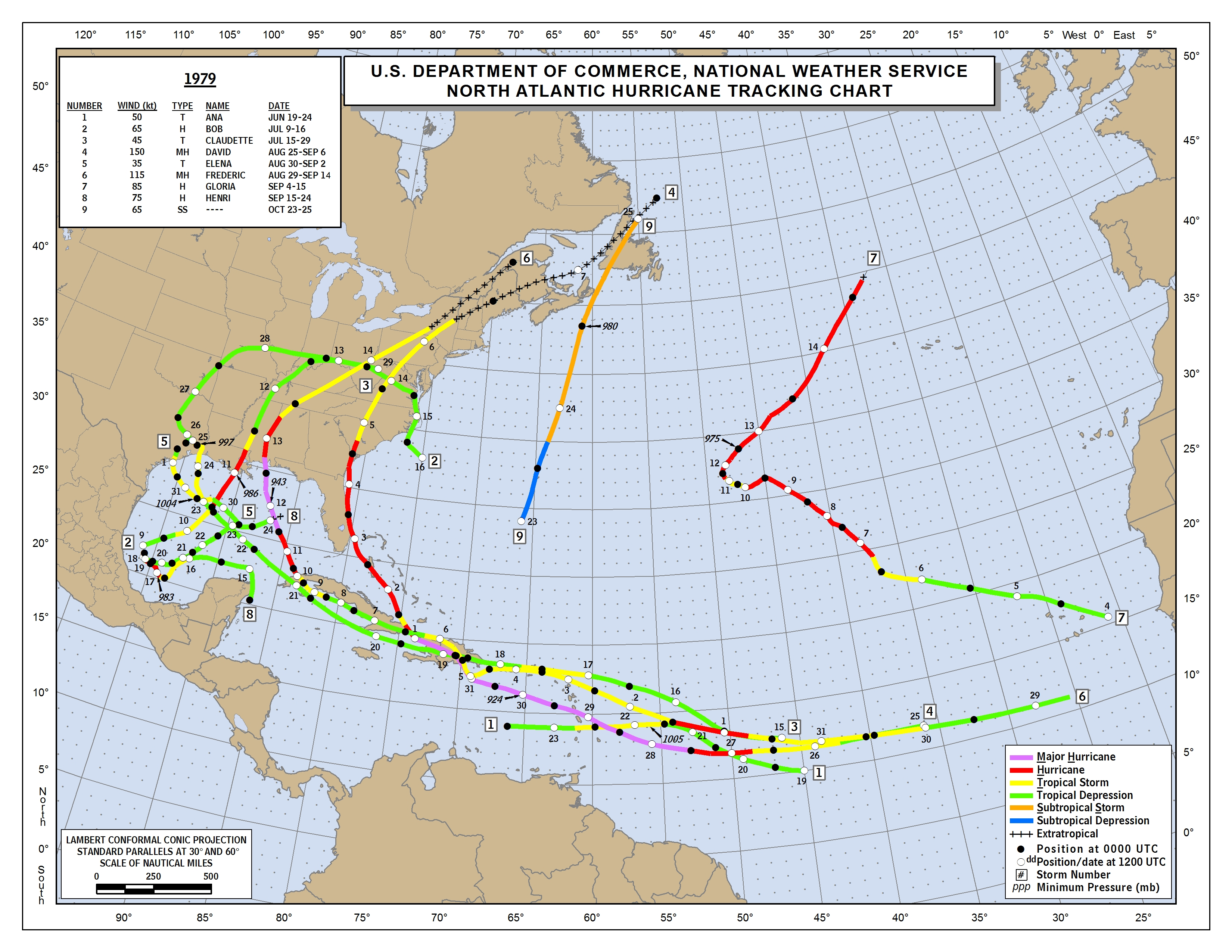
| 15 | 1979 | 9 | 20 | 1630 | Perry Hurricane Frederic Information Hurricane Information Hurricane Map Hurricane Information Hurricane Image Hurricane Information |
F2 | 3.0 | 27 | 0 | 2 | 5 S Marion Tornado touched down at airport damaging a hanger, 2 aircraft, several houses and mobile homes. A cotton picker was destroyed along with most of an pecan orchard. Many other trees and several power lines were downed. The Ames Bag and Packaging Company sustained major damage when the roof and 3 walls of one of the buildings collapsed. Dage estimates include $30,000 at the airport, $75,000 in the pecan grove, and $25,000 at the packaging company. The injuries were minor. Start: 32.55/-87.32 End: 32.52/-87.28 |
| 14 | 1979 | 9 | 13 | 0530 | Clarke Hurricane Frederic Information Hurricane Information Hurricane Map Hurricane Information Hurricane Image Hurricane Information |
F1 | 1.0 | 17 | 0 | 0 | Near Grove Hill Hurricane Frederic spawned a brief tornado near Grove Hill. One mobile home was destroyed and many trees were blown down. Start: 31.70/-87.78 End: 31.70/-87.78 |
| 13 | 1979 | 7 | 17 | 1640 | Mobile Hurricane Bob Information Hurricane Information Hurricane Map |
F0 | 0.1 | 10 | 0 | 0 | S Mobile Waterspout came ashore and knocked several trees down. Start: 30.58/-88.08 End: 30.58/-88.08 |
| 12 | 1979 | 7 | 11 | 1830 | Montgomery Hurricane Bob Information Hurricane Information Hurricane Map |
F0 | 0.1 | 10 | 0 | 0 | 25 SW Montgomery Little to no damage occurred. Start: 32.00/-86.48 End: 32.00/-86.48 |
| 11 | 1979 | 7 | 11 | 1720 | Covington Hurricane Bob Information Hurricane Information Hurricane Map |
F2 | 7.1 | 100 | 0 | 4 | W Red Level-6.2 Red Level 4 frame homes were destroyed and several other structures were damaged. One trailer was destroyed and numerous trees were blown down. Start: 31.40/-86.62 End: 31.48/-86.55 |
| 10 | 1979 | 7 | 5 | 1530 | Houston | F0 | 0.2 | 17 | 0 | 0 | Wicksburg Several chicken houses were damaged and some homes were damaged. Numerous trees were blown down. Start: 31.20/-85.63 End: 31.20/-85.63 |
| 9 | 1979 | 6 | 30 | 1855 | Baldwin | F1 | 0.3 | 17 | 0 | 0 | 6 SE Fairhope Brief tornado touched down near the Fish River and Highway 33. Numerous trees were uprooted. Minor damage occurred to a large chicken house. Start: 30.45/-87.82 End: 30.45/-87.82 |
| 8 | 1979 | 5 | 30 | 2000 | Jefferson | F1 | 25.8 | 20 | 0 | 1 | Birmingham-Pinson Small tornado, sighted by several individuals, touched down intermittently along 25 mile path northeastward through Metro Birmingham area from South Shades Crest section to Avondale to near Pinson. One man was injured. Three business firms suffered major roof damage, 1 car was extensively damaged, several homes and business establishments had minor to moderate damage. Numerous tree and power line damage. Start: 33.45/-87.03 End: 33.68/-87.93 |
| 7 | 1979 | 5 | 30 | 1730 | Fayette | F1 | 0.3 | 50 | 0 | 0 | Belk Damaged church roof, destroyed double wide mobile home, damaged several autos, partially unroofed 4 houses, and damaged timber. Start: 33.65/-87.93 End: 33.65/-87.93 |
| 6 | 1979 | 5 | 4 | 1351 | Elmore | F0 | 0.1 | 10 | 0 | 0 | Near Holtville Little or damage occurred. Start: 32.63/-86.32 End: 32.63/-86.32 |
| 5 | 1979 | 5 | 4 | 1315 | Mobile | F0 | 0.5 | 10 | 0 | 0 | Mobile Brief tornado touched down near the Mobile Aerospace Airport and the State Docks. Minor damage occurred at a warehouse. Start: 30.63/-88.07 End: 30.63/-88.07 |
| 4 | 1979 | 5 | 4 | 1238 | Jefferson | F0 | 0.1 | 10 | 0 | 0 | Near Birmingham Little to no damage occurred. Start: 33.58/-86.77 End: 33.58/-86.77 |
| 3 | 1979 | 4 | 11 | 2330 | Lauderdale | F1 | 0.5 | 20 | 0 | 1 | Florence Damaging thunderstorm wind and possibly several small tornadoes occurred across Florence. At least 200 homes, 100 automobiles, and several mobile homes were damaged. 2 mobile homes were demolished. Considerable damage to timber occurred. Start: 34.80/-87.67 End: 34.80/-87.67 |
| 2 | 1979 | 4 | 9 | 0115 | Dallas | F0 | 0.3 | 20 | 0 | 0 | Selma Brief touchdown in Selma, resulting in collapse of concrete wall of store, broken windows, and broken power lines. Start: 32.40/-87.02 End: 32.40/-87.02 |
| 1 | 1979 | 3 | 2 | 2020 | Mobile | F0 | 0.5 | 17 | 0 | 0 | Prichard Brief tornado touchdown caused mostly tree damage. A few home roofs were damaged and a drive-in-movie theatre screen was damaged. Start: 30.73/-88.05 End: 30.73/-88.05 |

