NWS Birmingham, Alabama
Weather Forecast Office
Radar Images 2253Z
 |
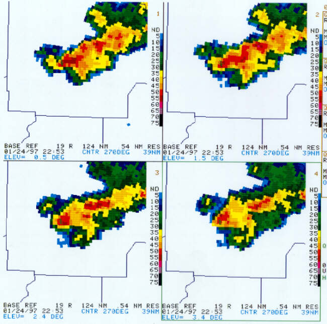
| The reflectivity gradient sharpened some more by the 2253Z volume scan. The storm appeared to be strengthening at this time as pixels of 55+ dBZ were now evident at 1.5, 2.4, and 3.4 degree elevations. The concavity on the southwest flank was still very evident. |
 |
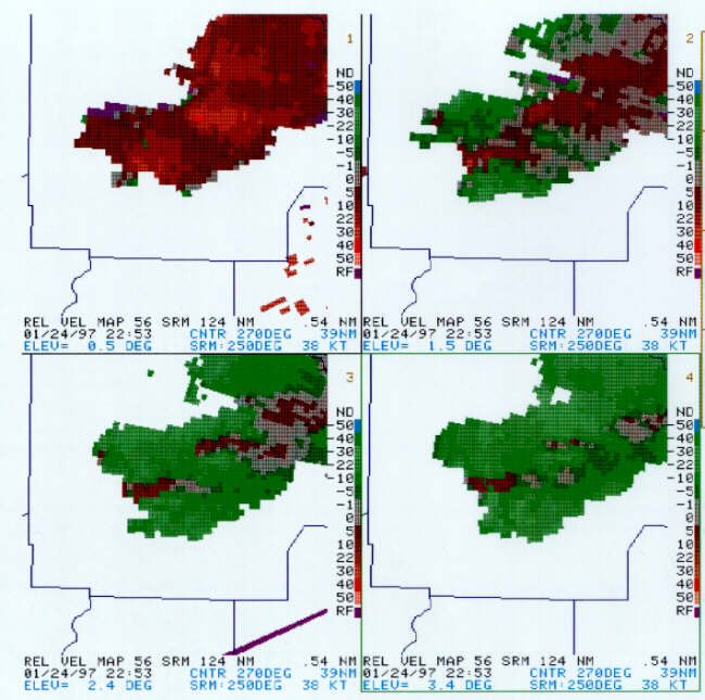
| Although a velocity couplet was not readily apparent at the lowest elevation at 2253Z, the 30-39 kts of storm-relative outbound velocities were right on the southwest flank. Vr increased to 35 kts at 1.5 degrees and remained 22 to 26 kts at higher elevations. |
Current Hazards
National Outlooks
Tropical
Local Storm Reports
Public Information Statement
Graphical Hazardous Weather Outlook
Current Conditions
Regional Weather Roundup
Rivers and Lakes
Drought Monitor
Forecasts
Fire Weather
Aviation Weather
Graphical Forecasts
Forecast Discussion
Air Quality
Climate and Past Weather
Past Events
Storm Data
Tornado Database
Daily Rainfall Plots
Local Climate Data
Tropical Cyclone Reports
Warnings and Other Products
Tornado Warnings
Severe Thunderstorm Warnings
Flash Flood Warnings
Winter Weather Warnings
Special Weather Statements
Non-Precipitation Warnings
Flood/River Flood Warnings
Productos en Español
Previsión de 7 DÃas
Conciencia y Preparación
Weather Safety
NOAA Weather Radio
Severe Weather Preparedness
Severe Safety Rules
Tornado Safety Rules
Severe Safety w/ ASL
Awareness Weeks
Severe Weather
Hurricane Preparedness
Summer Safety Campaign
Winter Weather
US Dept of Commerce
National Oceanic and Atmospheric Administration
National Weather Service
NWS Birmingham, Alabama
465 Weathervane Road
Calera, AL 35040
205-664-3010
Comments? Questions? Please Contact Us.

