The Blue Ash / Symmes Township Tornado: 25 Years Later
April 9, 1999
Surface Analysis
 |
||
|
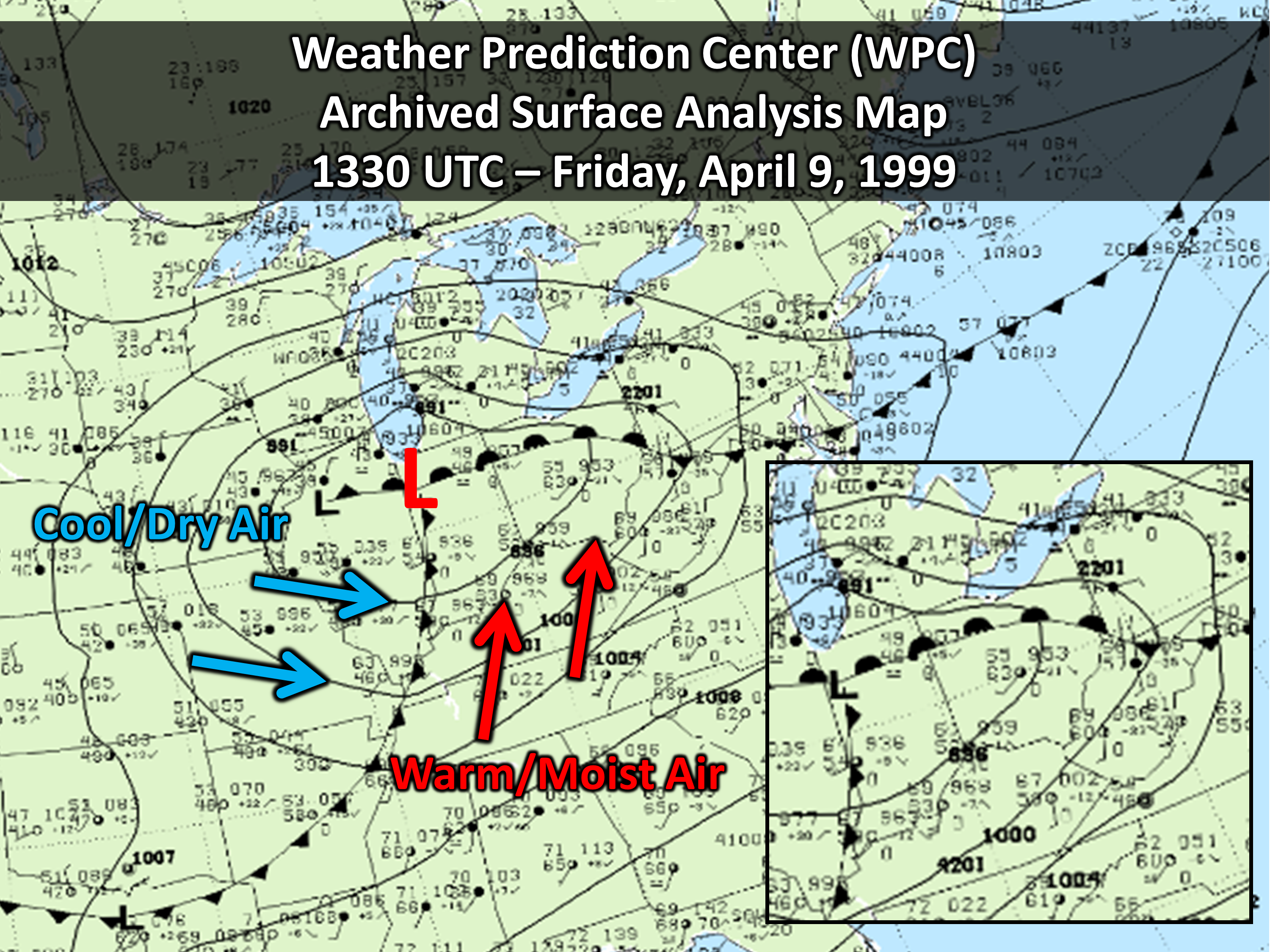
Archived surface analysis from the morning of April 9, 1999 shows an area of low pressure centered across the western Ohio Valley with a corresponding warm front draped across the northern part of the region with the attendant cold front further south/west of the immediate local area. This setup of surface features and frontal boundaries put the local area squarely in the warm sector of the system -- with temperatures in the mid/upper 60s and dewpoints in the upper 50s and lower 60s. Convection initially west of the Tri-State area moved into the area during the early morning hours through an environment with plenty of low level moisture and warmth to work with. |
||
Radar Evolution
 |
||
|
The regional radar mosaic shows an initial round of warm-frontal induced showers pivoting northeastward around 00z before the main broken cluster of storms pushes east through the Tri-State area from about 07z through 11z. The tornado-producing storm moved through the parts of southeastern Indiana and southwestern Ohio right around and shortly after 09z. In fact, according to survey findings and eyewitness accounts, the tornado was already ongoing at the 09z radar image shown above (with another tornado further north across Champaign and Union Counties occurring around 10z). After the morning round of storms, a secondary cluster of convection developed during the afternoon a bit further north and produced additional reports of severe weather during the afternoon, including some large hail and damaging wind gusts. |
||
 |
||
|
An animation of local radar shows the storm of interest, which was initially in Ripley County, IN, progressing east-northeastward from Dearborn County, IN through north-central parts of Hamilton County, OH before later moving into Warren and Clinton Counties. Although the storm produced significant damage in multiple locations throughout the local area, the worst of the damage occurred in the Blue Ash and Symmes Township areas in northeastern Hamilton County where it was determined the tornado reached its peak strength and was rated an F4 on the Fujita Scale. |
||
 |
 |
|
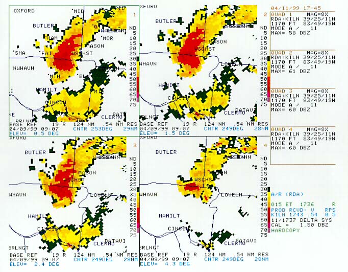
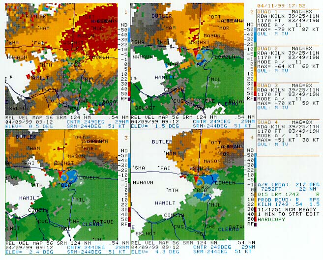
Local radar reflectivity at various low level elevation scans (0.5 upper left, 1.5 upper right, 2.4 lower left, 4.3 lower right) at 5:07 AM EDT shows a well-defined supercell thunderstorm progressing through northeastern Hamilton County with an appendage/hook on the southwest flank coincident with the low level mesocyclone responsible for the tornado. |
Local radar storm-relative motion (SRM) at various low level elevation scans (0.5 upper left, 1.5 upper right, 2.4 lower left, 4.3 lower right) at 5:12 AM EDT shows a well-defined rotation on the southwest flank of the core of the storm. In fact, the auto-algorithm detected the rotation and placed a red triangle near the location of strongest/tightest rotation, indicating the presence of a TVS (tornadic vortex signature). The F4 tornado was already on the ground at the time of this radar scan. |
 |
 |
|
The below track indicates the approximate overall path of the tornado circulation, which produced several distinct/separate tornadoes along its path. Fujita Scale values classify damage estimates at various points along the path of the storm. |
Various radar rotational velocity measurements along the path of the storm shown at different elevations (heights above the ground level) throughout the storm's evolution. The plot also indicates the diameter of the mesocyclone as well as the distance from the radar. |
Many warnings were issued throughout the course of the Blue Ash storm, as well as others that tracked through the local area that day. These warnings were issued both due to radar signatures and eyewitness spotter reports received from the field.
| Timeline of NWS Warnings - April 9, 1999 | ||
|
Time |
Warning Type |
Location |
| 4:02 AM | Tornado | Ripley County, Indiana |
| 4:02 AM | Tornado | Ripley County, Indiana (retransmitted) |
| 4:26 AM | Tornado | Dearborn County, Indiana |
| 4:47 AM | Severe Thunderstorm | Owen County, Kentucky |
| 4:52 AM | Tornado | Hamilton County, Ohio |
| 4:54 AM | Tornado | Owen County, Kentucky |
| 5:10 AM | Tornado | Grant County, Kentucky |
| 5:18 AM | Severe Thunderstorm | Clermont County, Ohio |
| 5:19 AM | Tornado | Warren County, Ohio |
| 5:25 AM | Tornado | Pendleton County, Kentucky |
| 5:36 AM | Severe Thunderstorm | Champagne County, Ohio |
| 5:41 AM | Tornado | Clinton County, Ohio |
| 5:45 AM | Severe Thunderstorm | Bracken County, Kentucky |
| 5:51 AM | Severe Thunderstorm | Union County, Ohio |
| 5:51 AM | Severe Thunderstorm | Union County, Ohio (retransmitted) |
| 7:16 AM | Severe Thunderstorm | Fairfield County and Licking County, Ohio |
| 11:26 AM | Severe Thunderstorm | Greene County, Ohio |
| 11:50 AM | Severe Thunderstorm | Madison County, Ohio |
| 11:55 AM | Severe Thunderstorm | Franklin County, Ohio |
| 12:28 PM | Severe Thunderstorm | Licking County, Ohio |
Storm Summary
PUBLIC INFORMATION STATEMENT NATIONAL WEATHER SERVICE WILMINGTON OH 637 PM EDT FRI APR 9 1999 A PRELIMINARY REPORT ON THE STORMS IN THE TRI-STATE AREA. A COMPLEX SYSTEM OF SEVERE THUNDERSTORMS OVER THE MISSOURI VALLEY THURSDAY AFTERNOON MIGRATED INTO THE OHIO VALLEY LATE THURSDAY EVENING AND FRIDAY MORNING...AND PRODUCED SUBSTANTIAL DAMAGE IN THE SOUTHWESTERN PORTION OF OHIO AND SOUTHEAST INDIANA. HARDEST HIT AREAS WERE BLUE ASH...MONTGOMERY AND LOVELAND...LOCATED NORTH THROUGH EAST OF CINCINNATI. NUMEROUS INJURIES HAVE BEEN REPORTED...AND AS MANY AS 9 UNCONFIRMED DEATHS ARE BEING BLAMED ON THIS TORNADO. (Actual final fatality count was 4.) PRELIMINARY INVESTIGATION BY NATIONAL WEATHER SERVICE PERSONNEL... INDICATED AN F3 TORNADO THAT INTENSIFIED BRIEFLY TO F4 WITH WINDS IN EXCESS OF 200 MPH TOUCHED DOWN IN THE BLUE ASH AREA. AT LEAST 200 HOMES WERE DEMOLISHED AND ANOTHER 400 WERE DAMAGED. THE WIDTH OF THIS STORM VARIED FROM AS LITTLE AS 400 FEET TO NEARLY A MILE...WHILE THE ESTIMATED PATH OF THIS TORNADO WAS 6 TO 7 MILES. SEVERAL EYEWITNESSES REPORTED HEARING SIRENS AND TOOK NECESSARY PROTECTIVE ACTION. ALSO...SEVERAL PEOPLE WHO ATTENDED WEATHER SERVICE SPOTTER TRAINING...INDICATED THAT THE SEVERE WEATHER PREPAREDNESS PLANS DEVELOPED PROVED TO BE VALUABLE. IT IS IMPORTANT TO REMEMBER THAT THIS IS A PRELIMINARY INVESTIGATION AND FURTHER INFORMATION WILL BE FORTHCOMING. TORRENCE |
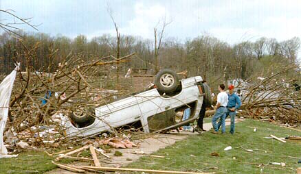
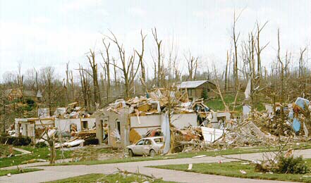
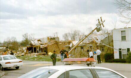
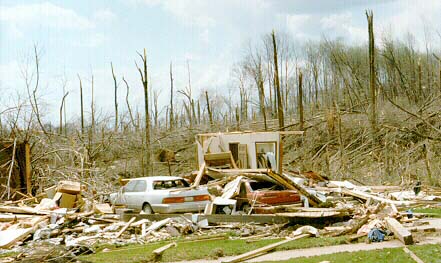
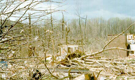
Although damage occurred at multiple locations throughout the Tri-State area, the most severe damage occurred in the vicinity of Blue Ash and Symmes Townships in northeastern Hamilton County, OH. At various points within the survey, it was concluded that the tornado temporarily reached F4 status, which at that time indicated wind speeds approached or even exceeded 200 MPH. Unfortunately, the storm claimed 4 lives that morning.
 |
 |
 |
 |
 |
 |
|
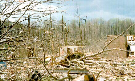
The above photos were taken during official NWS Storm Surveys conducted to determine the cause of the damage, as well as the path length and width of the tornado. It was determined that more than 100 homes were destroyed, with hundreds more partially damaged. Total damage was estimated to be in excess of $25 million. |
||

