|
Snow & Snow Squalls Scattered snow showers and squalls developed in the local area as an upper level low pressure system moved across the Great Lakes region. Although it was a tad later in the season than is typical for snow squalls, several intense squalls developed and moved through the Cincinnati and Dayton metro areas during the morning commute. With subfreezing surface temperatures in place, many area roads quickly turned icy, resulting in numerous wrecks (some fatal) in the Cincinnati and Dayton areas. The icy conditions and numerous accidents resulted in the brief shutdown of I-75 north of Cincinnati. |
Public Information Statement
Spotter Reports
National Weather Service Wilmington OH
1011 AM EST Thu Mar 08 2018

The following are unofficial observations taken during the past 8
hours for the storm that has been affecting our region. Appreciation
is extended to highway departments, cooperative and cocorahs
observers, spotters and media for these reports. This summary is also
available on our home page at www.weather.gov/iln

********************STORM TOTAL SNOWFALL********************

LOCATION          STORM TOTAL     TIME/DATE   COMMENTS
                     SNOWFALL           OF
                     /INCHES/   MEASUREMENT

OHIO

...Butler County...
   2 SE Fairfield         0.5   752 AM  3/08  Trained Spotter

...Franklin County...
   KCMH John Glenn Cbus   0.6   700 AM  3/08  6-HR Snowfall

...Montgomery County...
   KDAY Dayton Cox Apt    1.2   700 AM  3/08  6-Hr Snowfall


***********************6 HOUR SNOWFALL***********************

LOCATION               6 HOUR     TIME/DATE   COMMENTS
                     SNOWFALL           OF
                     /INCHES/   MEASUREMENT

OHIO

...Clinton County...
   Wilmington Air Park    0.1   554 AM  3/08  ASOS


**********************24 HOUR SNOWFALL**********************

LOCATION              24 HOUR     TIME/DATE   COMMENTS
                     SNOWFALL           OF
                     /INCHES/   MEASUREMENT

INDIANA

...Fayette County...
   2 NE Alpine            0.5   700 AM  3/08  Co-Op Observer

...Franklin County...
   Brookville             0.5   700 AM  3/08  Co-Op Observer

...Ripley County...
   4 NE Osgood            1.0   800 AM  3/08  CoCoRaHS

OHIO

...Clark County...
   7 SW Springfield       1.2   730 AM  3/08  CoCoRaHS
   Springfield 2          0.5   700 AM  3/08  Co-Op Observer
   3 ENE Yellow Springs   0.5   708 AM  3/08  CoCoRaHS

...Darke County...
   1 ENE Pitsburg         1.3   820 AM  3/08  CoCoRaHS
   3 WSW Potsdam          1.0   615 AM  3/08  CoCoRaHS

...Delaware County...
   4 NNW Dublin           1.0   800 AM  3/08  CoCoRaHS
   1 E Lewis Center       0.8   700 AM  3/08  CoCoRaHS

...Fayette County...
   1 E Washington Court   0.5   730 AM  3/08  Co-Op Observer

...Franklin County...
   8 NE Columbus          1.0   700 AM  3/08  CoCoRaHS
   8 NW Columbus          0.5   800 AM  3/08  CoCoRaHS

...Greene County...
   1 WNW Clifton          0.5   708 AM  3/08  CoCoRaHS
   3 SE Fairborn          0.5   700 AM  3/08  CoCoRaHS

...Hamilton County...
   3 W Cheviot            0.5   700 AM  3/08  Co-Op Observer

...Hocking County...
   Laurelville            0.8   700 AM  3/08  Co-Op Observer

...Logan County...
   3 N Huntsville         0.5   700 AM  3/08  Co-Op Observer

...Miami County...
   4 S Troy               1.2   800 AM  3/08  CoCoRaHS

...Montgomery County...
   1 WSW Union            1.0   700 AM  3/08  CoCoRaHS
   2 SE Miamisburg        0.5   700 AM  3/08  CoCoRaHS

...Pickaway County...
   1 NW Circleville       0.5   600 AM  3/08  Co-Op Observer
&&
|
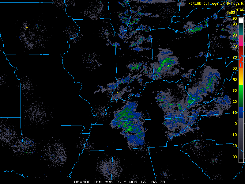 |
| Regional Radar Mosaic At Approximately 5 AM local time showing an intense snow squall in southwestern Ohio. |

