Wilmington, OH
Weather Forecast Office
|
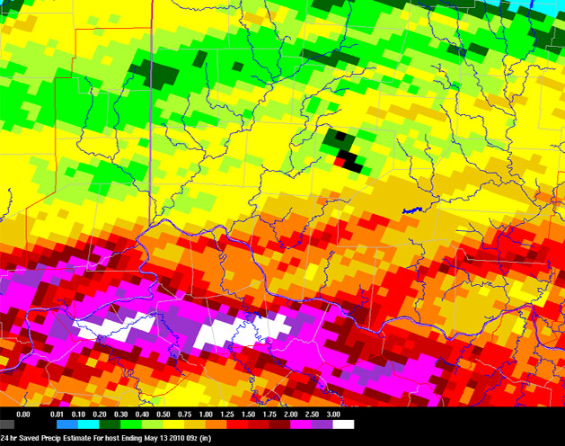
Heavy Rain & Flooding A frontal boundary stalled near the Ohio River during the morning of May 12. This led to numerous rounds of thunderstorms which dropped widespread heavy rain across parts of southern Ohio, southeast Indiana and northern Kentucky. Widespread rainfall amounts in excess of 2 inches were common, with some reports over 3 inches. This same area was hit with heavy rain just a week prior, which made it particularly prone to flooding. Several reports of flash flooding were received including numerous road closures and streams overflowing their banks.
|
FORECASTS
Hourly Weather Graph
Graphical Forecast
Area Forecast Graphics
Area Forecast Discussion
River Forecasts and Obs
WEATHER HISTORY
Past Observed Weather
Local Climate Graphs
Local Event Summaries
OH / ILN Tornado Climatology
This Day in Weather History
NATIONAL CENTERS
Storm Prediction Center
National Hurricane Center
Weather Prediction Center
Aviation Weather Center
Climate Prediction Center
NCEI
US Dept of Commerce
National Oceanic and Atmospheric Administration
National Weather Service
Wilmington, OH
1901 South State Route 134
Wilmington, OH 45177
937-383-0031
Comments? Questions? Please Contact Us.