|
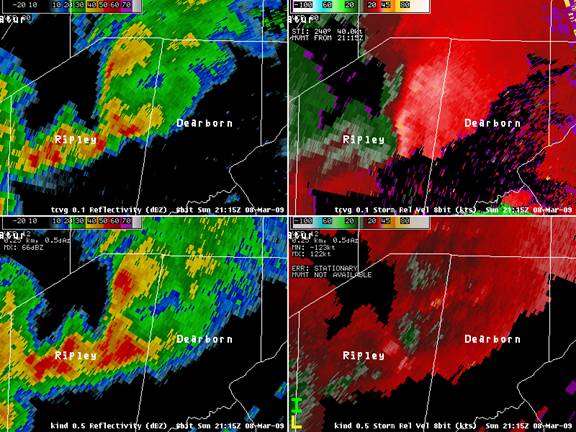
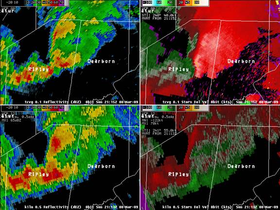
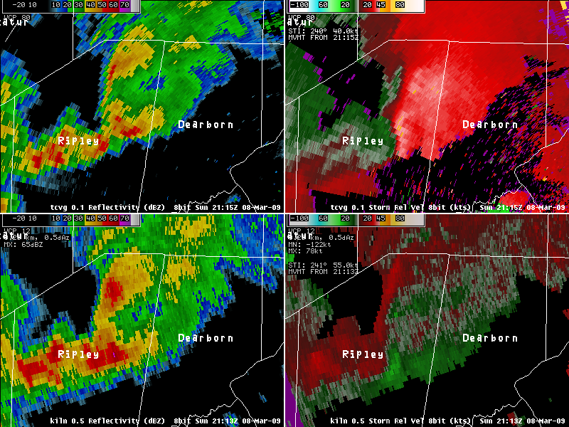
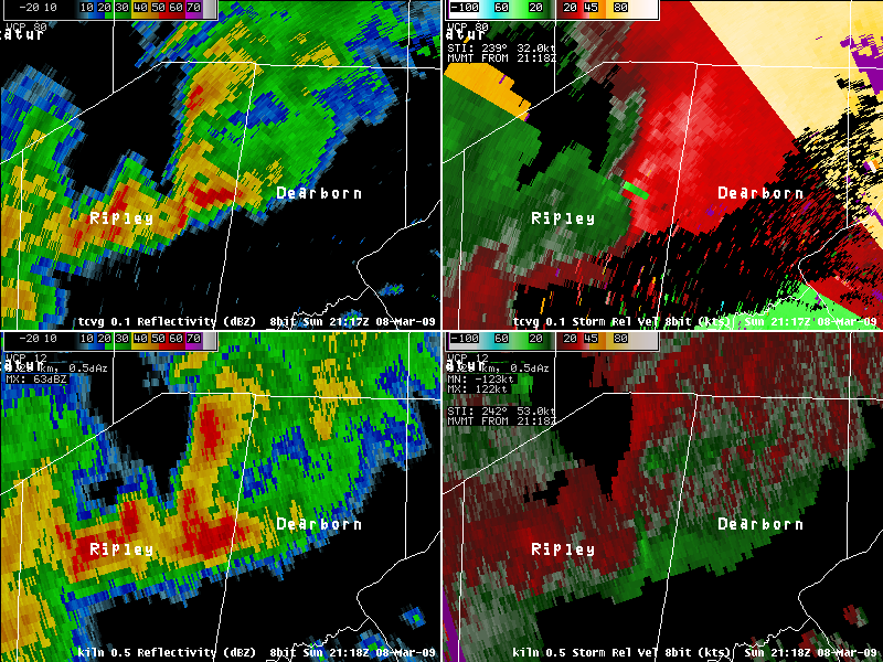
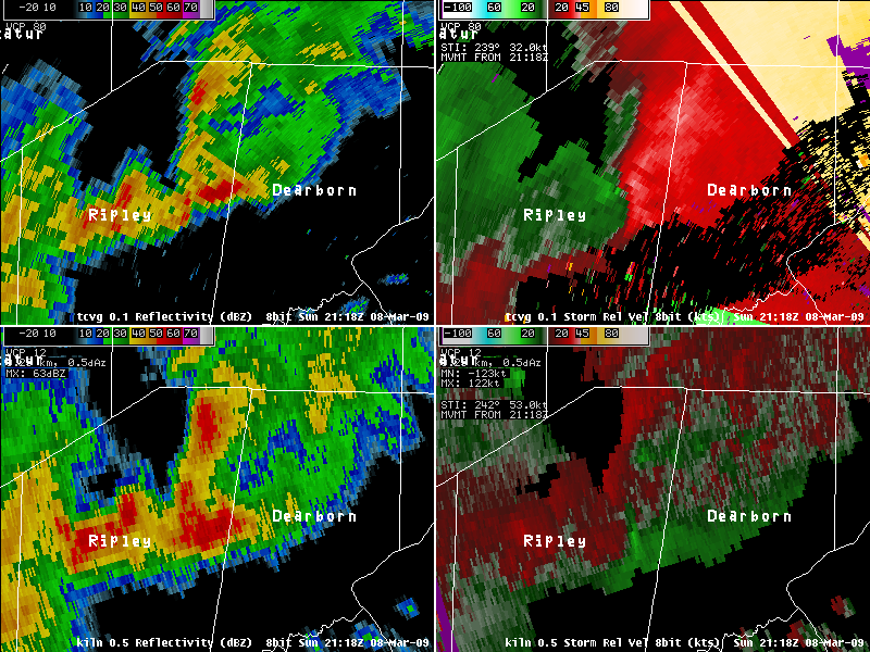
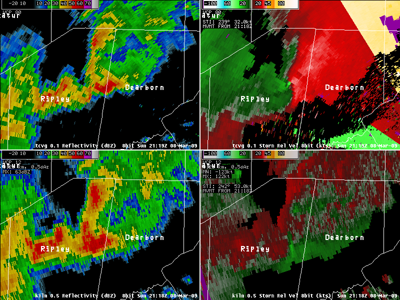
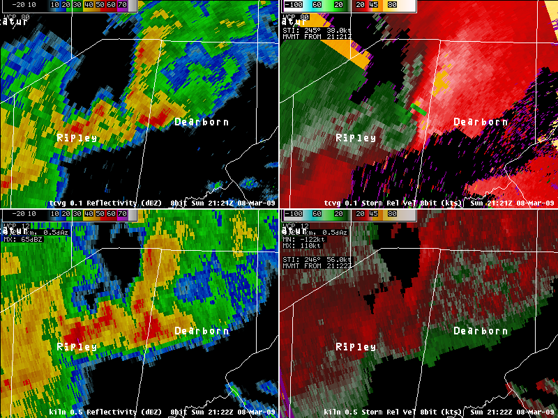
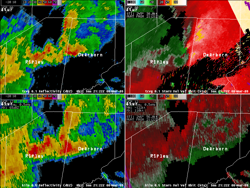
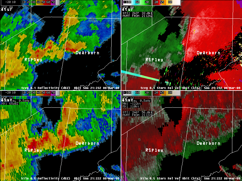
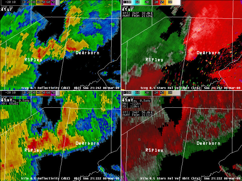
Tornado In Ripley County, IN During a period from April to September in 2008, National Weather Service offices gained access to data from forty five Terminal Doppler Weather Surveillance Radars (TDWRs) at major airports across the country. Reflectivity data has also recently become available to the public in the RIDGE 2 radar display mosaic. The Wilmington, OH (ILN) County Warning Area (CWA) has been fortunate to have a TDWR located at major airports near Dayton, Columbus, and Cincinnati. The TDWRs bring the potential for data sampling at lower levels of a storm, more frequent radar data at the lowest levels, more detailed information given a storm's closer proximity to the radar, and ultimately more information for warning forecasters. On March 8, 2009, the Cincinnati-Northern Kentucky International Airport radar (TCVG) provided data which helped detect rotation associated with a brief tornado touchdown. TDWRs provide a radar scanning strategy which provides new data at the lowest elevation tilt every minute. In comparison, the WSR-88Ds can provide radar scans at the lowest tilt every four and a half minutes in their fastest scanning strategy. During the Ripley County tornado, the radar provided valuable reflectivity and storm relative motion (SRM) velocity data. In Figure 1, the TCVG SRM shows the broad rotation of the storm tightening into a couplet. The couplet is not visible from KIND, but more of a broad rotation is evident with the storm. The storm touched down briefly at approximately 2122Z. Notice the couplet on TCVG from 2121Z-2124Z. The 0.5 degree elevation scans from KIND provided data of the storm at 2120Z and 2124Z, missing the first three minutes of the couplet. In Figure 2, seen below, KILN shows no evidence of a tightening circulation. The reflectivity data from TCVG indicates an apparent cell merger on a pre-existing storm scale boundary. This suggests that the tornado may have developed from a non-descending mesocyclone. These processes can be difficult to detect using WSR-88D data since they are often short-lived and develop just a few thousand feet above ground level. The addition of one minute data from the 0.1 degree elevation scan of TCVG in this case provided the ability to see short-lived reflectivity and velocity signatures which occurred between scans from both KILN and KIND. TCVG provided more scans by the minute, detecting the evolution of the storm. |
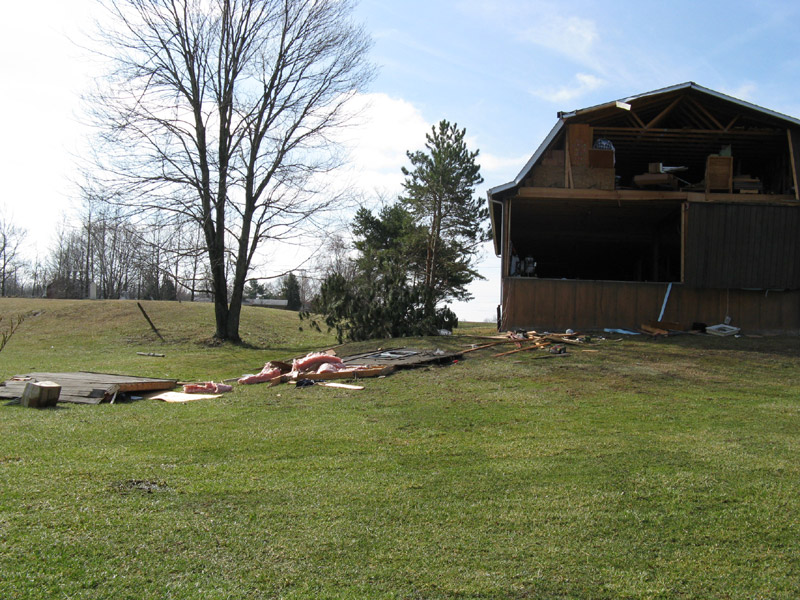
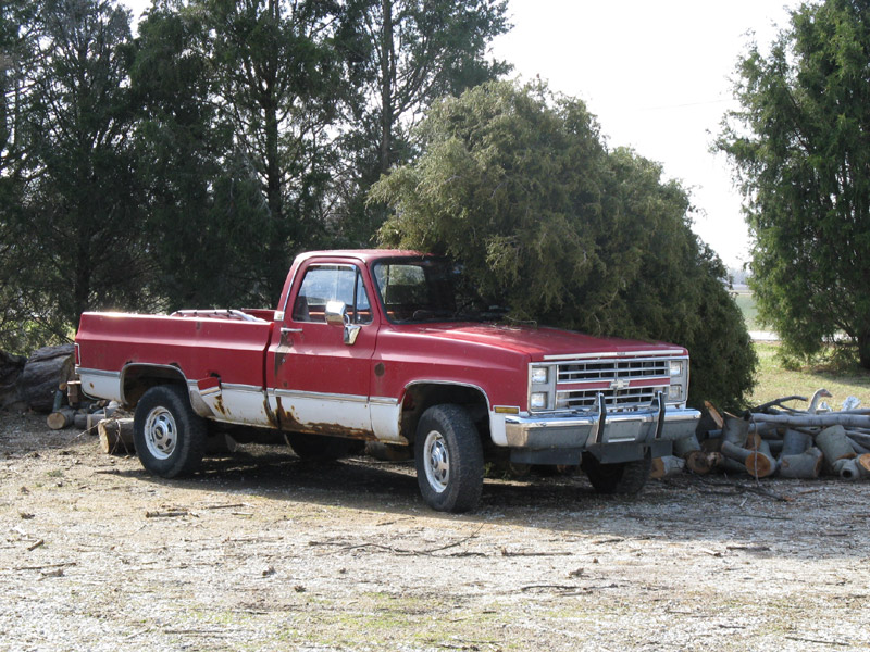
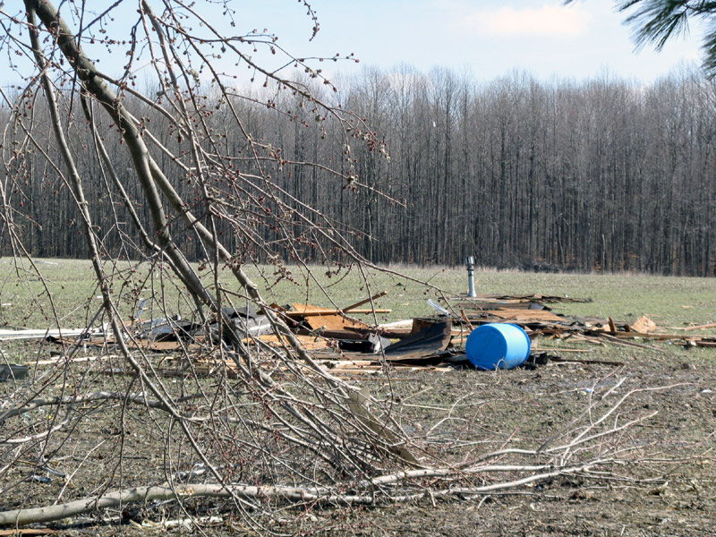
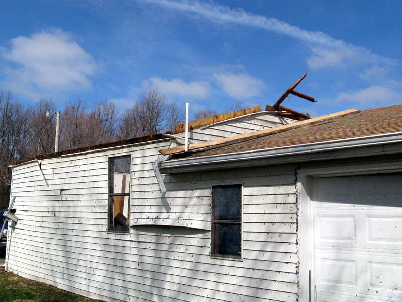
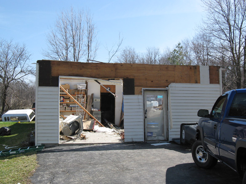
PUBLIC INFORMATION STATEMENT NATIONAL WEATHER SERVICE WILMINGTON OH 414 PM EDT MON MAR 9 2009 ...EF1 TORNADO CONFIRMED IN NORTHEAST RIPLEY COUNTY... A NATIONAL WEATHER SERVICE DAMAGE SURVEY HAS CONFIRMED A TORNADO TOUCHDOWN IN NORTHEAST RIPLEY COUNTY ABOUT THREE MILES SOUTH OF SUNMAN ON SUNDAY AFTERNOON MARCH 8. THE TORNADO BRIEFLY TOUCHED DOWN IN TWO LOCATIONS JUST WEST AND NORTH OF THE INTERSECTION OF INDIANA STATE ROUTES 101 AND 48. THE FIRST AREA OF DAMAGE OCCURRED ON A PROPERTY LOCATED ALONG STATE ROUTE 48 ABOUT A QUARTER MILE WEST OF THE INTERSECTION OF STATE ROUTES 48 AND 101. A LARGE TWO-STORY BARN SUSTAINED ROOF DAMAGE AND HAD BOTH METAL GARAGE DOORS BLOWN OUT. MUCH OF THE NORTH- FACING WALL OF THE GARAGE AND SEVERAL SMALL OBJECTS IN THE BARN WERE BLOWN OUT AND THROWN INTO AN ADJACENT CORNFIELD TO THE NORTHEAST. A SECOND SMALLER BARN BEHIND THE HOME HAD THE BACK PART OF ITS METAL ROOF PEELED OR REMOVED. TWO CEDAR TREES IN THE VICINITY OF THE LARGE BARN WERE UPROOTED. THE HOMEOWNER AND HIS SON BOTH WITNESSED THE TORNADO LIFT UP IN THE CORNFIELD AND THEN COME BACK DOWN IN THE VICINITY OF STATE ROUTE 101 JUST NORTH OF ITS INTERSECTION WITH STATE ROUTE 48. IT WAS IN THIS LOCATION THAT THE SECOND AREA OF DAMAGE WAS LOCATED. THE MOST SIGNIFICANT DAMAGE WAS IN THIS LOCATION ALONG STATE ROUTE 101...TO A STAND-ALONE GARAGE AND THE BACK PORTION OF A HOUSE. THE FRONT PART OF THE GARAGE HAD ITS ROOF COMPLETELY REMOVED AND DEPOSITED IN A FEW PARTS IN THE FIELD TO THE EAST OF THE PROPERTY. SEVERAL PIECES OF THE ROOF TRUSSES AND FIBERGLASS WERE SCATTERED BEHIND THE GARAGE AS WELL. INSULATION WAS STUCK TO THE ENTIRE SOUTH SIDE OF THE GARAGE...AND THE WEST-FACING GARAGE DOOR WAS BLOWN OUT. THE BACK PART OF THE GARAGE REMAINED LARGELY INTACT WITH LITTLE ROOF DAMAGE. THE HOMEOWNERS INDICATED THAT THIS PART OF THE GARAGE WAS BUILT AT A LATER TIME THAN THE FRONT PART OF THE GARAGE. ADDITIONAL DAMAGE OCCURRED TO A BACK ROOM TO THE HOUSE. THIS WAS AN ADDITION TO THE HOUSE...BUILT AT THE SAME TIME AS THE FRONT PORTION OF THE GARAGE WHICH SUSTAINED THE BRUNT OF THE DAMAGE. THE ENTIRE ROOM WAS SHIFTED OFF THE FOUNDATION BY AS MUCH AS SIX INCHES AND THE DOOR WAS BLOWN OUT. SEVERAL MAPLE TREES ALONG THE BACK EDGE OF THE PROPERTY WERE KNOCKED DOWN. BASED ON THE TYPE OF DAMAGE TO THE STRUCTURES AND HOW THEY WERE BUILT...ESTIMATED MAXIMUM WINDS ARE 85 TO 90 MPH WHICH CORRELATES TO THE LOW END OF THE EF1 CATEGORY. EF1 WINDS RANGE FROM 86 TO 109 MPH. THE BROKEN PATH LENGTH WAS ABOUT 0.5 MILES. PATH WIDTH WAS ABOUT 25 YARDS. $$ |
| Radar Images | |||
 |
 |
 |
|
| 4-Panel Radar Imagery of Storm | |||
 |
 |
| TCVG 4-Panel Radar Imagery | |
 |
 |
| TCVG 4-Panel Radar Imagery | |
 |
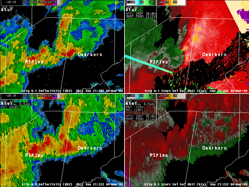 |
| TCVG 4-Panel Radar Imagery | |
 |
 |
| TCVG 4-Panel Radar Imagery | |
 |
 |
| TCVG 4-Panel Radar Imagery | |
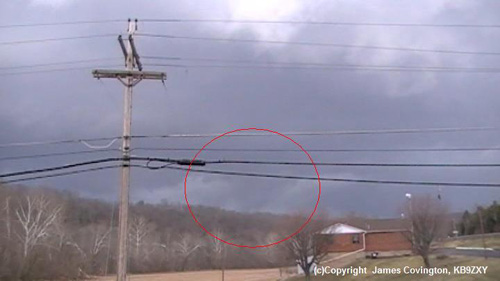
| Storm Damage Photos: | |||
 |
 |
 |
|
 |
 |
 |
|

