|
Round 3 of Severe Weather - Wednesday Morning Eventually, another intense squall line developed out of this region of storms over Illinois. It continued east through Indiana, and finally strengthened as it entered Ohio at around 7 AM. The line of storms carved another swath of wind damage across the eastern Cincinnati metro area, and locations east from there. In addition, a brief tornado touched down in Newtown (eastern Hamilton County). There were numerous reports of marginally severe hail as well. Flash flooding also became an issue in the Tri-State region and further east, as heavy rain continued to fall over areas which had already experienced plenty. |
PRELIMINARY LOCAL STORM REPORT
NATIONAL WEATHER SERVICE WILMINGTON OH
..TIME...   ...EVENT...      ...CITY LOCATION...     ...LAT.LON...
..DATE...   ....MAG....      ..COUNTY LOCATION..ST.. ...SOURCE....
            ..REMARKS..

0627 AM     FLOOD            2 NNE OSTRANDER         40.29N 83.20W
06/04/2008                   DELAWARE           OH   PUBLIC

            STREAMS WERE COMING OUT OF THEIR BANKS.

0743 AM     HAIL             3 SSW BLUE ASH          39.21N 84.40W
06/04/2008  U0.75 INCH       HAMILTON           OH   PUBLIC

0748 AM     TORNADO          NEWTOWN                 39.12N 84.35W
06/04/2008                   HAMILTON           OH   NWS STORM SURVEY

            SIGNIFICANT TREE DAMAGE REPORTED IN NEWTOWN...WITH SOME
            STRUCTURAL DAMAGE AS WELL TO A NURSERY AND OTHER
            BUSINESSES. A BROKEN DAMAGE PATH OF 1.5 MILES EXTENDED
            THROUGH THE AREA. THE TORNADO HAS BEEN RATED AN EF0 ON
            THE ENHANCED FUJITA SCALE WITH WIND SPEEDS ESTIMATED
            BETWEEN 70 AND 75 MPH.

0748 AM     TSTM WND DMG     3 S MADEIRA             39.14N 84.37W
06/04/2008                   HAMILTON           OH   TRAINED SPOTTER

            NUMEROUS TREE LIMBS DOWNED...UP TO 20-40 FEET IN LENGTH
            AND ONE FOOT IN DIAMETER. NUMEROUS SMALL TREES AND POWER
            LINES DOWNED.

0750 AM     HAIL             CINCINNATI              39.14N 84.51W
06/04/2008  E0.88 INCH       HAMILTON           OH   PUBLIC

0756 AM     HAIL             3 ESE CINCINNATI        39.12N 84.45W
06/04/2008  E0.75 INCH       HAMILTON           OH   NWS EMPLOYEE

0756 AM     HAIL             5 WSW FAYETTEVILLE      39.15N 84.01W
06/04/2008  U0.88 INCH       CLERMONT           OH   PUBLIC

0758 AM     HAIL             5 SW FAYETTEVILLE       39.14N 84.00W
06/04/2008  E0.88 INCH       CLERMONT           OH   PUBLIC

0801 AM     TSTM WND DMG     MIDLAND                 39.31N 83.91W
06/04/2008                   CLINTON            OH   TRAINED SPOTTER

            MANY TREES DOWNED DUE TO HIGH WINDS...WITH SOME FALLING
            ON BUILDINGS AND CAUSING STRUCTURAL DAMAGE.

0808 AM     TSTM WND DMG     WESTBORO                39.28N 83.91W
06/04/2008                   CLINTON            OH   NWS STORM SURVEY

            NUMEROUS TREES DOWNED...WITH A FEW HOMES SUSTAINING MINOR
            ROOF AND SIDING DAMAGE. STRAIGHT-LINE WINDS WERE SURVEYED
            TO BE THE CAUSE...ESTIMATED AT AROUND 60 MPH.

0852 AM     TSTM WND DMG     CHILLICOTHE             39.34N 82.99W
06/04/2008                   ROSS               OH   LAW ENFORCEMENT

            LARGE LIMBS DOWN ACROSS ROADS.

0900 AM     FLASH FLOOD      BROOKVILLE              39.42N 85.01W
06/04/2008                   FRANKLIN           IN   LAW ENFORCEMENT

            AT LEAST 8 ROADS ACROSS THE COUNTY WITH WATER RUNNING
            ACROSS THEM.

0900 AM     FLASH FLOOD      MANCHESTER              39.15N 85.01W
06/04/2008                   DEARBORN           IN   LAW ENFORCEMENT

            AT LEAST 5 COUNTY ROADS WITH HIGH WATER RUNNING ACROSS
            THEM.

0900 AM     FLASH FLOOD      CINCINNATI              39.14N 84.51W
06/04/2008                   HAMILTON           OH   LAW ENFORCEMENT

            SEVERAL MAJOR INTERCHANGES THROUGH CITY WITH VERY HIGH
            WATER.

0958 AM     TSTM WND DMG     LOGAN                   39.54N 82.40W
06/04/2008                   HOCKING            OH   PUBLIC

            TREES WERE BLOWN DOWN.

1000 AM     FLASH FLOOD      2 E OXFORD              39.51N 84.71W
06/04/2008                   BUTLER             OH   LAW ENFORCEMENT

            NUMEROUS ROADS WITH VERY HIGH WATER. A HANDFUL OF
            RESIDENTS EVACUATED NEAR CANAL ROAD IN ST. CLAIR
            TOWNSHIP.

1000 AM     FLASH FLOOD      INDEPENDENCE            38.95N 84.55W
06/04/2008                   KENTON             KY   LAW ENFORCEMENT

            2 ROADS CLOSED DUE TO HIGH WATER

1050 AM     TSTM WND DMG     WHEELERSBURG            38.73N 82.85W
06/04/2008                   SCIOTO             OH   EMERGENCY MNGR

            TREES WERE BLOWN DOWN.

$$
|
| Radar Pictures From Event #3 | |||
 |
 |
 |
 |
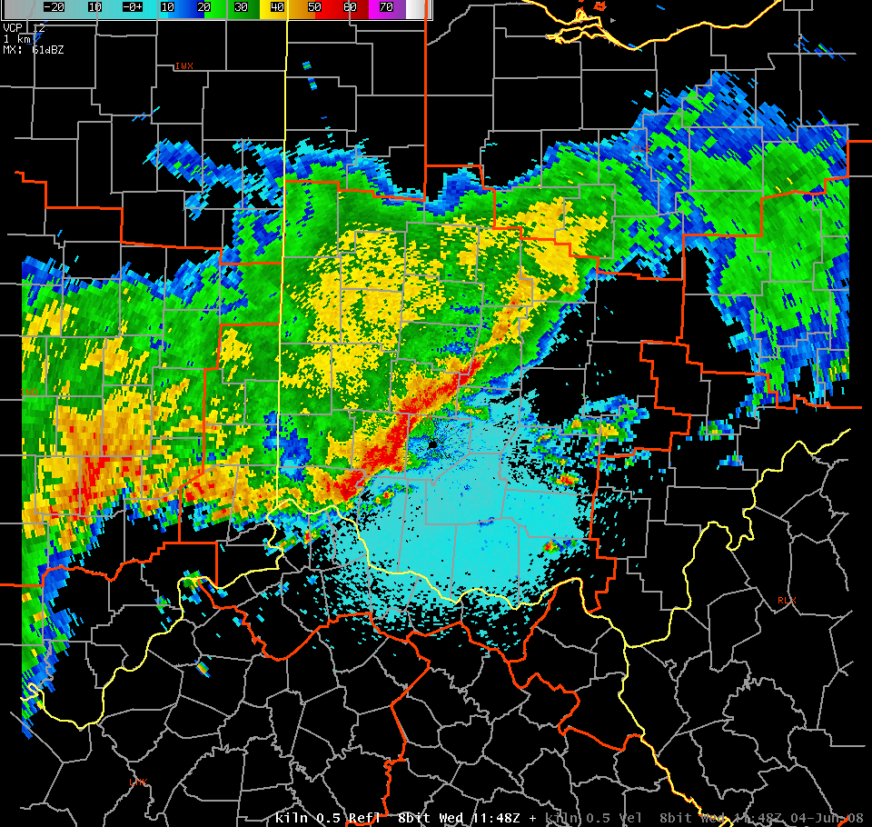
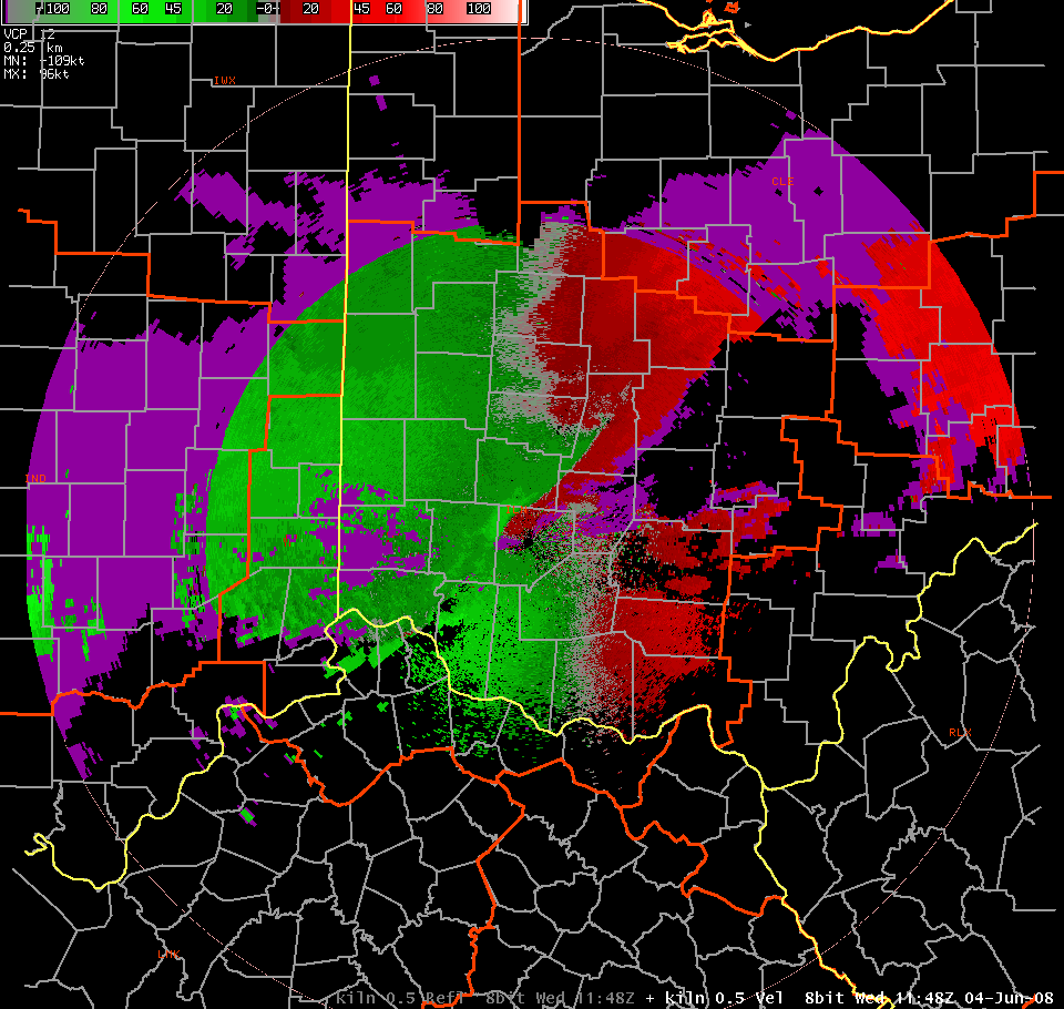
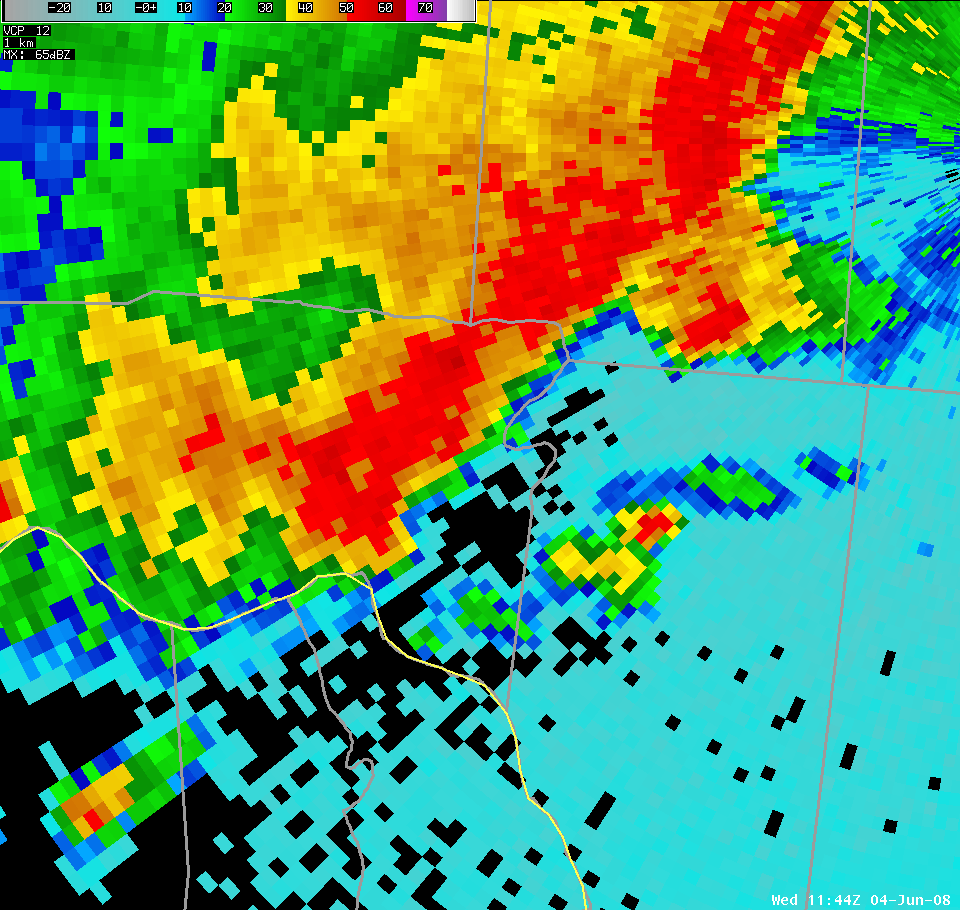
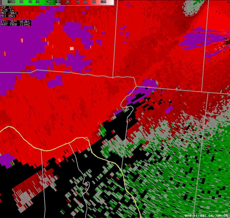
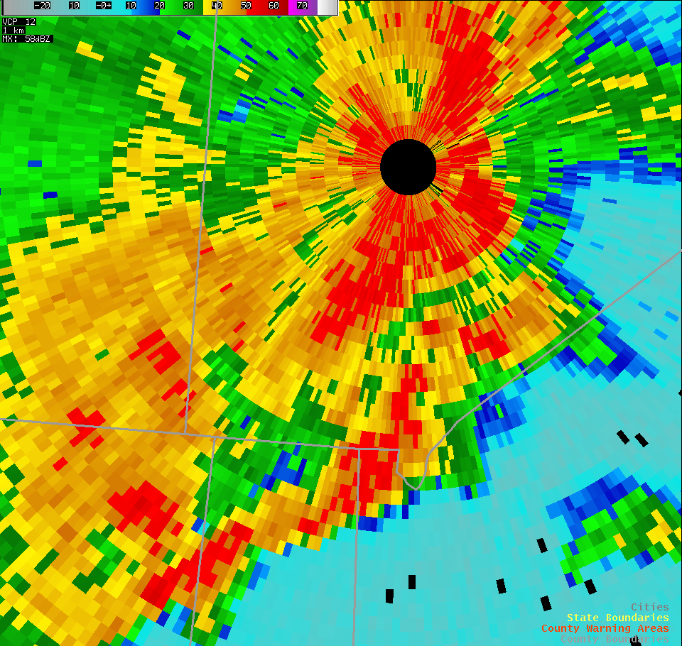
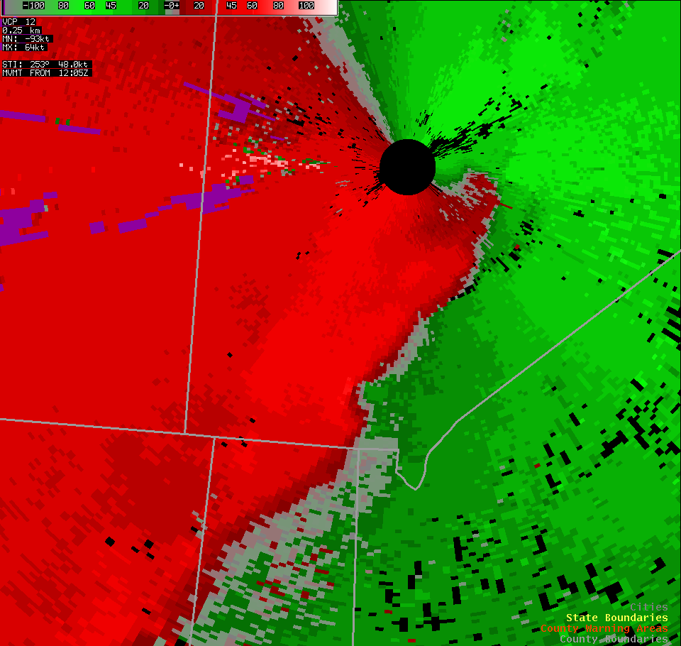
| At about 8:05 AM, wind damage occurred near Westboro in southern Clinton County. The damage appeared to be associated with a small break in the squall line, as evident in the reflectivity data (left). Storm relative motion data (right) shows a slight "twist" in the leading edge of the line of storms. This small meso-vortex enhanced the straight line winds in the area, with damage observed near the outward-bowing "wave" in the line. Note that this data does not indicate a strong "gate-to-gate" couplet that one would expect to see as indication of a tornado. | |||
 |
 |
 |
 |
| At about 8:05 AM, wind damage occurred near Westboro in southern Clinton County. The damage appeared to be associated with a small break in the squall line, as evident in the reflectivity data (left). Storm relative motion data (right) shows a slight "twist" in the leading edge of the line of storms. This small meso-vortex enhanced the straight line winds in the area, with damage observed near the outward-bowing "wave" in the line. Note that this data does not indicate a strong "gate-to-gate" couplet that one would expect to see as indication of a tornado. | |||

