|
Round 1 of Severe Weather - Tuesday Afternoon |
PRELIMINARY LOCAL STORM REPORT
NATIONAL WEATHER SERVICE WILMINGTON OH
..TIME...   ...EVENT...      ...CITY LOCATION...     ...LAT.LON...
..DATE...   ....MAG....      ..COUNTY LOCATION..ST.. ...SOURCE....
            ..REMARKS..

0220 PM     HAIL             WORTHVILLE              38.61N 85.07W
06/03/2008  E0.75 INCH       CARROLL            KY   LAW ENFORCEMENT

0315 PM     TSTM WND DMG     FRIENDSHIP              38.97N 85.15W
06/03/2008                   RIPLEY             IN   AMATEUR RADIO

            LARGE LIMBS DOWN.

0320 PM     TSTM WND DMG     2 W FARMERS RETREAT     38.98N 85.14W
06/03/2008                   RIPLEY             IN   AMATEUR RADIO

            LARGE PORCH DESTROYED AND LARGE TREES UPROOTED AND
            CARPORT OFF FOUNDATION AND THROWN SEVERAL YARDS

0320 PM     TSTM WND DMG     4 S DILLSBORO           38.96N 85.06W
06/03/2008                   DEARBORN           IN   AMATEUR RADIO

            NUMEROUS LARGE TREES DOWN.

0328 PM     TSTM WND DMG     RISING SUN              38.95N 84.86W
06/03/2008                   OHIO               IN   TRAINED SPOTTER

            NUMEROUS TREES AND LIMBS DOWN.

0335 PM     TSTM WND DMG     BLUE ASH                39.25N 84.38W
06/03/2008                   HAMILTON           OH   LAW ENFORCEMENT

            TREES DOWN IN NUMEROUS LOCATIONS ACROSS THE COUNTY.

0345 PM     TSTM WND DMG     RICHWOOD                38.92N 84.63W
06/03/2008                   BOONE              KY   TRAINED SPOTTER

            ESTIMATED WINDS AT 55 TO 60 MPH. BRANCHES DOWN.

0345 PM     HAIL             RICHWOOD                38.92N 84.63W
06/03/2008  E0.75 INCH       BOONE              KY   TRAINED SPOTTER

0346 PM     TSTM WND DMG     MILFORD                 39.17N 84.28W
06/03/2008                   CLERMONT           OH   LAW ENFORCEMENT

            TREES DOWN.

0346 PM     TSTM WND DMG     ATWOOD                  38.87N 84.54W
06/03/2008                   KENTON             KY   LAW ENFORCEMENT

            NUMEROUS TREES DOWN IN SOUTHERN HALF OF COUNTY

0347 PM     TSTM WND DMG     ALEXANDRIA              38.96N 84.38W
06/03/2008                   CAMPBELL           KY   LAW ENFORCEMENT

            TREES DOWN SCATTERED ACROSS COUNTY

0351 PM     TSTM WND GST     BURLINGTON              39.02N 84.72W
06/03/2008  E60.00 MPH       BOONE              KY   TRAINED SPOTTER

0351 PM     HAIL             BURLINGTON              39.02N 84.72W
06/03/2008  E0.88 INCH       BOONE              KY   TRAINED SPOTTER

0400 PM     TSTM WND DMG     BUTLER                  38.79N 84.37W
06/03/2008                   PENDLETON          KY   LAW ENFORCEMENT

            TREES DOWN.

0441 PM     TSTM WND DMG     4 NE MOUNT OLIVET       38.57N 83.98W
06/03/2008                   ROBERTSON          KY   TRAINED SPOTTER

            TWO BARNS BLOWN DOWN. LIMBS AND POWER LINES DOWN
            COUNTYWIDE.

0454 PM     TSTM WND DMG     ORANGEBURG              38.57N 83.69W
06/03/2008                   MASON              KY   LAW ENFORCEMENT

            TREES DOWN.

0507 PM     TSTM WND DMG     1 S VANCEBURG           38.58N 83.32W
06/03/2008                   LEWIS              KY   LAW ENFORCEMENT

            TREES DOWN.

$$
|
| Radar Pictures From Event #1 | |||
 |
 |
 |
 |
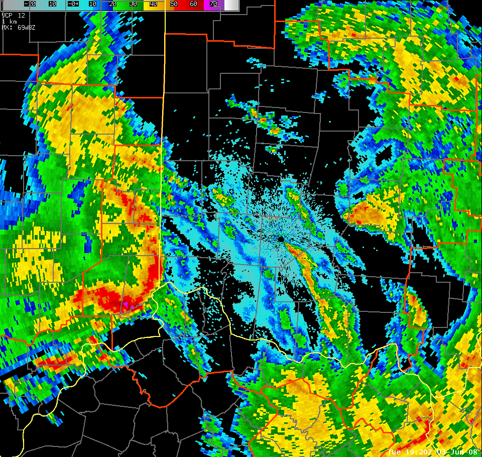
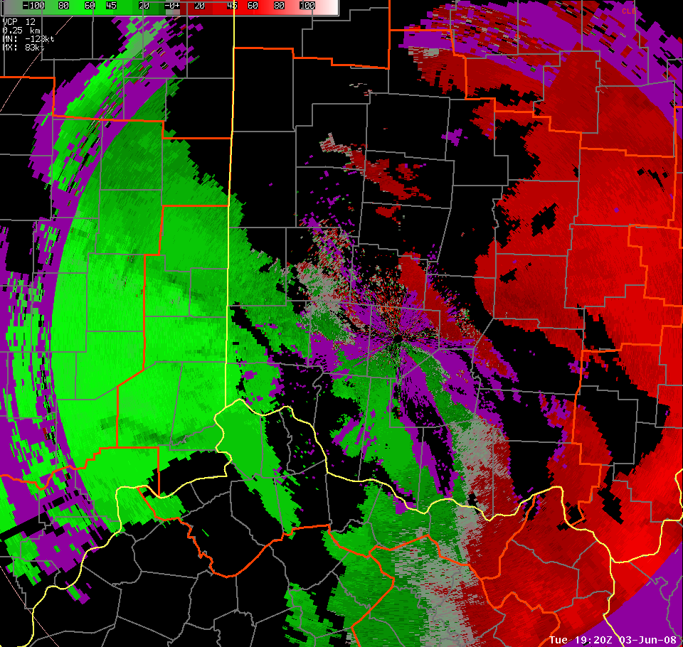
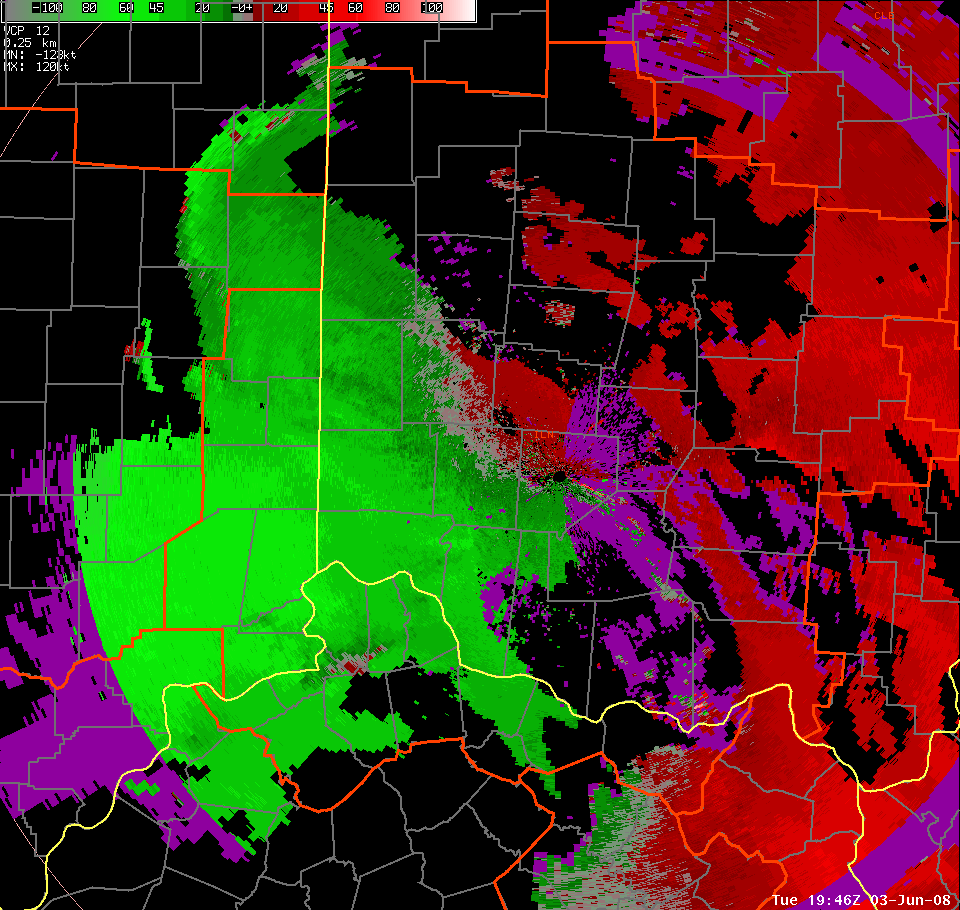
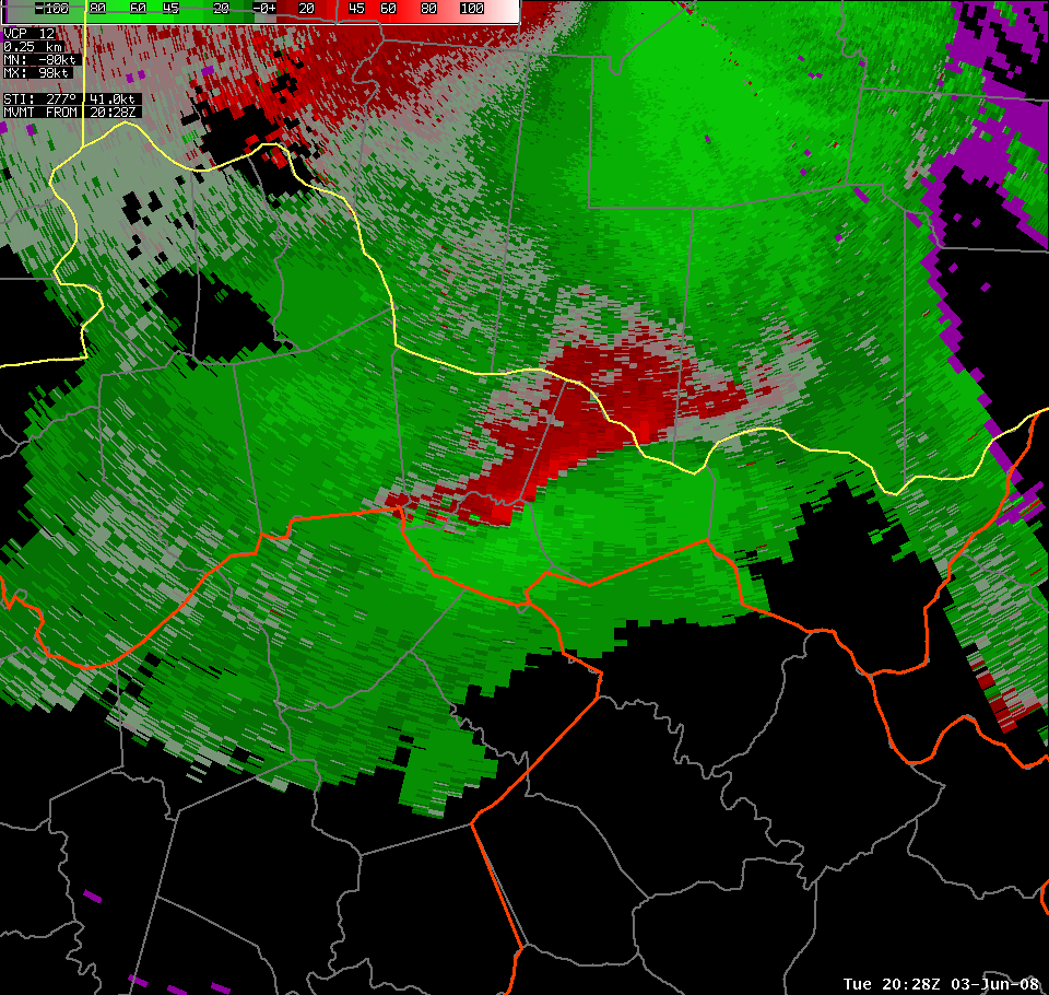
| At 3:20 PM, the line of storms began pushing into Ohio. Intense reflectivities (left) were detected with the cell in southern Dearborn County, Indiana. Velocity data (right) shows velocity data, with very strong inbound (green) winds of 60-70 knots detected. | |||
 |
 |
 |
 |
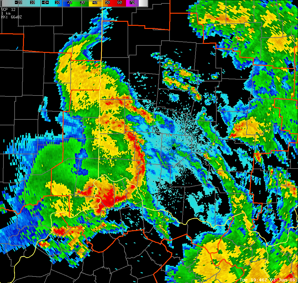
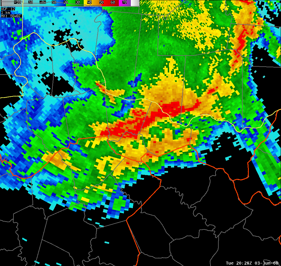
| At 3:46 PM, the line continued pushing eastward. While strong winds were reported with the bowing area in Ohio, the strongest cells remained in Kentucky. Reflectivity (left) and velocity (right) data both show intense storms across Boone and Kenton Counties. | |||
 |
 |
 |
 |
| At 3:48 PM, the strongest cells as seen on reflectivity data (left) were located over Bracken, Mason, and Robertson Counties in Kentucky. Storm relative motion data (right) shows a strong MARC (mid-altitude radial convergence) signature in the mid-levels of this storm. This likely led to enhanced wind damage across northern Robertson County. Some rotation is also evident, indicating a mid-level mesocyclone, which is to be expected in an intense storm such as this one. | |||

