|
The Mini-Supercell / Marginal Hail Event of November 5, 2007 |
PRELIMINARY LOCAL STORM REPORT...SUMMARY
NATIONAL WEATHER SERVICE WILMINGTON OH
549 PM EST MON NOV 05 2007

..TIME...   ...EVENT...      ...CITY LOCATION...     ...LAT.LON...
..DATE...   ....MAG....      ..COUNTY LOCATION..ST.. ...SOURCE....
            ..REMARKS..

0156 PM     HAIL             HAMILTON                39.39N 84.56W
11/05/2007  E0.88 INCH       BUTLER             OH   TRAINED SPOTTER

0215 PM     HAIL             MORROW                  39.35N 84.13W
11/05/2007  E1.25 INCH       WARREN             OH   PUBLIC

0222 PM     HAIL             2 N WILMINGTON          39.47N 83.83W
11/05/2007  M0.50 INCH       CLINTON            OH   NWS EMPLOYEE

0229 PM     HAIL             ERLANGER                39.01N 84.59W
11/05/2007  E0.75 INCH       KENTON             KY   TRAINED SPOTTER

0238 PM     HAIL             WILMINGTON              39.44N 83.83W
11/05/2007  M0.75 INCH       CLINTON            OH   NWS EMPLOYEE

0241 PM     HAIL             ALEXANDRIA              38.96N 84.38W
11/05/2007  E0.88 INCH       CAMPBELL           KY   EMERGENCY MNGR

            MANY LOCATIONS IN THE COUNTY.

0245 PM     HAIL             NEW RICHMOND            38.96N 84.28W
11/05/2007  M1.00 INCH       CLERMONT           OH   TRAINED SPOTTER

0245 PM     HAIL             BETHEL                  38.96N 84.08W
11/05/2007  E0.75 INCH       CLERMONT           OH   PUBLIC

0250 PM     HAIL             INDEPENDENCE            38.95N 84.55W
11/05/2007  E0.75 INCH       KENTON             KY   PUBLIC

0250 PM     HAIL             REYNOLDSBURG            39.96N 82.80W
11/05/2007  E0.75 INCH       FRANKLIN           OH   PUBLIC

0257 PM     HAIL             BETHEL                  38.96N 84.08W
11/05/2007  M1.00 INCH       CLERMONT           OH   TRAINED SPOTTER

0259 PM     HAIL             GROVE CITY              39.87N 83.07W
11/05/2007  E0.75 INCH       FRANKLIN           OH   PUBLIC

0300 PM     HAIL             NEW HOPE                38.96N 83.91W
11/05/2007  E0.75 INCH       BROWN              OH   LAW ENFORCEMENT

0305 PM     HAIL             CANAL WINCHESTER        39.85N 82.82W
11/05/2007  E0.88 INCH       FRANKLIN           OH   PUBLIC

0310 PM     HAIL             NEWARK                  40.07N 82.42W
11/05/2007  E0.25 INCH       LICKING            OH   PUBLIC

0310 PM     HAIL             PICKERINGTON            39.89N 82.77W
11/05/2007  E0.75 INCH       FAIRFIELD          OH   PUBLIC

0312 PM     HAIL             4 S NEWARK              40.01N 82.42W
11/05/2007  E0.75 INCH       LICKING            OH   PUBLIC

0315 PM     HAIL             WINCHESTER              38.94N 83.65W
11/05/2007  E1.00 INCH       ADAMS              OH   LAW ENFORCEMENT

0315 PM     HAIL             CIRCLEVILLE             39.60N 82.94W
11/05/2007  E0.75 INCH       PICKAWAY           OH   PUBLIC

0315 PM     HAIL             CIRCLEVILLE             39.60N 82.94W
11/05/2007  E0.75 INCH       PICKAWAY           OH   PUBLIC

0315 PM     HAIL             CIRCLEVILLE             39.60N 82.94W
11/05/2007  E1.00 INCH       PICKAWAY           OH   PUBLIC

0315 PM     HAIL             BUCKEYE LAKE            39.94N 82.48W
11/05/2007  E0.75 INCH       LICKING            OH   PUBLIC

0315 PM     HAIL             CANAL WINCHESTER        39.85N 82.82W
11/05/2007  E1.00 INCH       FRANKLIN           OH   PUBLIC

0320 PM     HAIL             LANCASTER               39.72N 82.60W
11/05/2007  E0.88 INCH       FAIRFIELD          OH   PUBLIC

0320 PM     HAIL             PICKERINGTON            39.89N 82.77W
11/05/2007  E1.25 INCH       FAIRFIELD          OH   PUBLIC

0324 PM     HAIL             2 E BUENA VISTA         39.55N 82.64W
11/05/2007  E0.75 INCH       HOCKING            OH   PUBLIC

$$
|
 |
Upper levels: A broad 300-hPa trough was deepening over the Great Lakes as a 120-kt jet max rounded the base. A large area of upper divergence can be seen in the vicinity of the jet streak across much of Indiana and western Ohio, supportive of deep-layer lifting ahead of the front. |
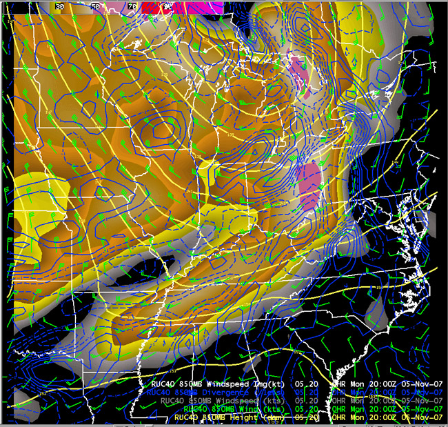 |
850 hPa: The trough at 850-hPa was deeper than at upper levels as it moved into the Ohio Valley. A 40-50 kt jet existed ahead of the trough. A weak cold front is evident in the wind and height fields, which at 20 UTC was located near the I-71 corridor. Despite being on the tail end of the jet max where divergence would be expected, convergence along the front was sufficient to initiate convection. |
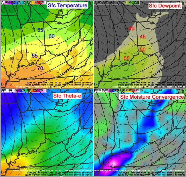 |
Surface: The surface cold front lagged the 850-hPa front, and at 21 UTC was moving into northwestern parts of the CWA. Surface temperatures were only around 60 degrees, and the highest dewpoints were confined to the lower Ohio Valley. Dewpoints in ILN's CWA were only in the upper 40s. This led to a stable surface layer. |
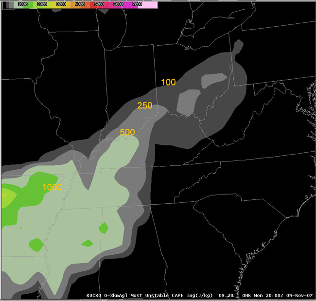 |
MUCAPE: Most-unstable CAPE across ILN's CWA was low and did not exceed 500 J/kg. This instability originated from near 800 hPa. |
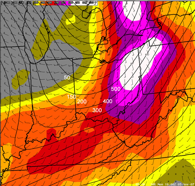 |
0-3 km Helicity: Helicity values were high, ranging from 200-500 m2/s2. |
Radar Signatures:
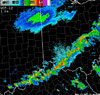 |
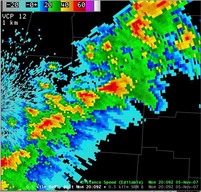
0.5° Radar Loop: 1.5-hour loop shows quick initiation, rapid storm movement (~50-kt) and the miniature nature of supercells. |
|
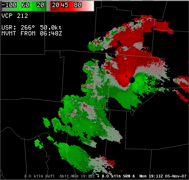
Storm 1: Brown County |
Storm 2: Pickaway County | Storm 3: Warren County | |||
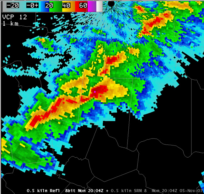 0.5° Reflectivity |
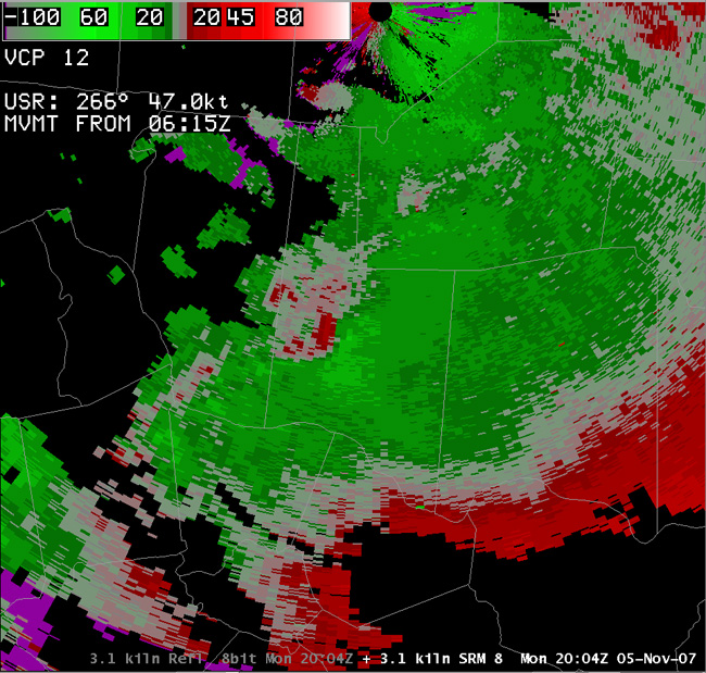 3.1° SRM (11.4 kft) |
 0.5° Reflectivity |
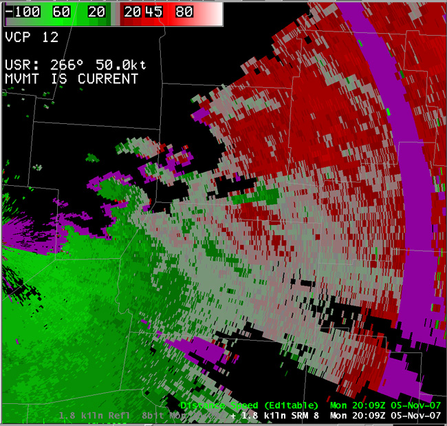 1.8° SRM (8.9 kft) |
 0.5° Reflectivity |
 8.0° SRM (15.3 kft) |
|
These 3 supercells were among the storms which produced severe hail that afternoon. All of them exhibited a midlevel mesocyclone, ranging from 8-17 kft. Most of them were broad and weak, though the Warren County storm exhibited a deeper and tighter mesocyclone, along with a weak echo region. This storm produced the largest hail of the day (1.25" in Morrow). |
|||||
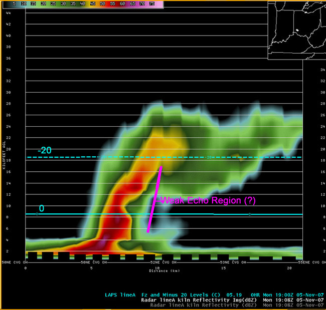 |
Vertical Cross Section of Storm 3: The precipitation core in this storm is small both vertically and horizontally. Maximum reflectivity values are around 65 dBz, but these are located below the freezing level. The highest cores aloft are between 55 and 60 dBz which extend slightly above the -10 °C level (not marked), and the 45-dBz values extend to about 22 kft which is well above the -20 °C level. An ill-defined weak echo region up to 16 kft may also be present, but is difficult to tell for sure in this image. The echo tops around 27 kft correspond well with the equilibrium level of 26.5 kft in the Bufkit sounding. Note that the highest reflectivities and possible WER both top out around 16-17 kft...near the level of the midlevel mesocyclone shown in storm 3 above. This is also around the level that CAPE is its widest, which suggests the updraft is likely strongest near this level. |
| Discussion: In summary, this case illustrates two important points in low CAPE situations. First, it is important to see if CAPE is tall and skinny or short and fat. The latter case may still be capable of strong but short updrafts which makes the low value of total CAPE deceiving. Second, the amount of low level shear is important to determine if mesocyclones are favored (high 0-3 km helicity and favorable 0-6 km shear). |

